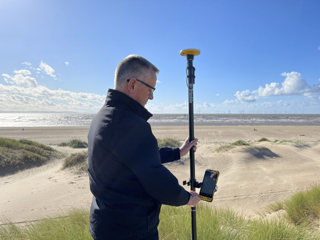
- Trimble Catalyst
- Soarvo software
- KOREC consultancy
- …and Tony Fahey – a truly inspirational 82 year old
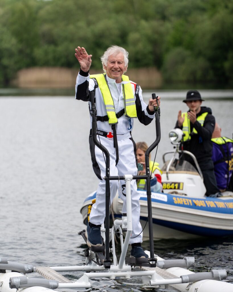
Tony Fahey on the aqua elliptica
Here at KOREC, we’re used to helping our customers deliver projects through innovative use of Trimble technology. But every now and then, a truly unusual request comes along that reminds us why we love what we do and why, behind the scenes, it’s not all about construction, surveying and engineering.
Earlier in the year, we were delighted to be invited by the UK’s largest dedicated surveying business, Survey Solutions, to play a key role in an inspirational world record attempt by a truly motivating 82-year-old, retired businessman, Tony Fahey.
His name may sound familiar because he was once one of the fastest powerboat racers in the world holding multiple records. It’s therefore brilliantly fitting that his latest record attempt is quite possibly the slowest of his life: a 24-hour “walk on water” challenge to raise money for the children’s charity Make-A-Wish UK. Instead of a thundering powerboat, Tony and his team are propelling a human-powered aqua elliptica – imagine a cross-trainer on water – around Sale Water Park near Manchester.
But how do you measure Tony and his team’s progress on water, and provide distance and time information for verification by the Guinness Book of Records?
Step forward KOREC’s Rob Partridge, and John Cartledge and Soarvo’s Paul Brodin.
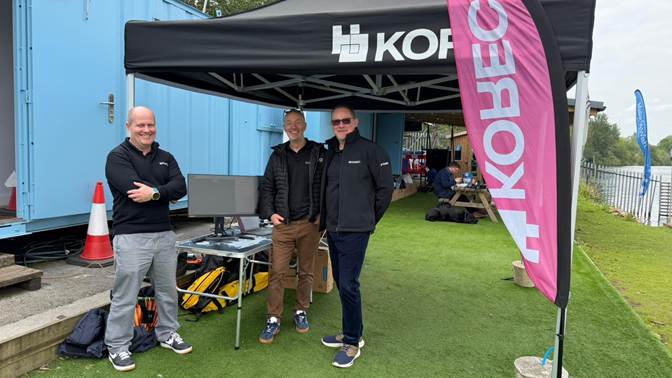
The KOREC and Soarvo team, Rob Partridge, Paul Brodin and John Cartledge
What was needed
- Live GPS tracking of the aqua elliptical
- Accurate recording of a position every second, distance, speed, and timing
- An interactive public display so supporters could follow Tony’s progress in real time
- The verifiable data needed for official record ratification (Guinness World Records approval is currently underway)
The challenges
- The battery life of the proposed GPS positioning system was based on a full day’s work rather than the 24 hours required
- The system would have to be positioned on the craft away from all moving parts
- The Soarvo software would need to be customised to record the pinged positions every second rather than the usual every 15 minutes
How it was done – collaboration!
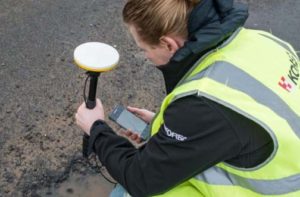
- Trimble Catalyst is an incredibly easy to use GNSS system made up of a DA2 Trimble Receiver and a subscription based on accuracy, in this case centimetre positions were required. The system would be linked to a Trimble TDC600 data logger running the Soarvo software app which would ping positions
- Following extensive testing on dry land and then on the aqua elliptica by Rob and John, the perfect position was found to mount the system on a seat pole that had been left on the craft
- Meanwhile, John had calculated exactly what was needed battery wise to keep the system running for 24 hours. Three options were assessed and the ‘least intelligent’ selected so that it would not manage its own power and potentially turn itself off during the world record attempt
- Soarvo’s Paul Brodin customised the Soarvo software to record a bread trail every second rather than every 15 minutes
- This information would be transmitted to Soarvo running on a laptop at the edge of the water to provide live updates on positions and times
- A form was built to record the 86,400 points (every second for 24 hours)
- A back up system and battery were prepped
On the day
Following a couple of dry runs, the world record attempt began with Tony kicking off the first leg, completing an exhausting single continuous effort of 2 hours and 20 minutes, covering 5 miles – the longest single stint by any team member.
The rest of the challenge was completed as a relay by his family team who rotated in shifts through the night.
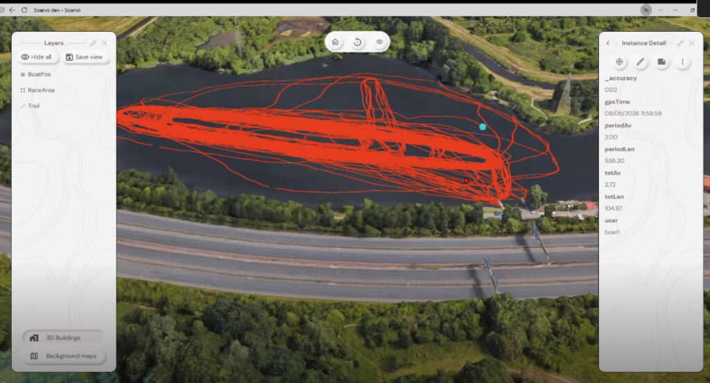
Soarvo software was used to update the public
From the land Rob and John tracked the system’s performance and both took turns in the rescue boat where they were pleased to report that the site of the system’s solid blue light and glow from the TDC600 screen provided reassurance that everything was working correctly.
Due to the low temperatures affecting the battery life, Rob and John disconnected the TDC600 from this source letting it run on its own internal battery towards the end of the WR attempt.
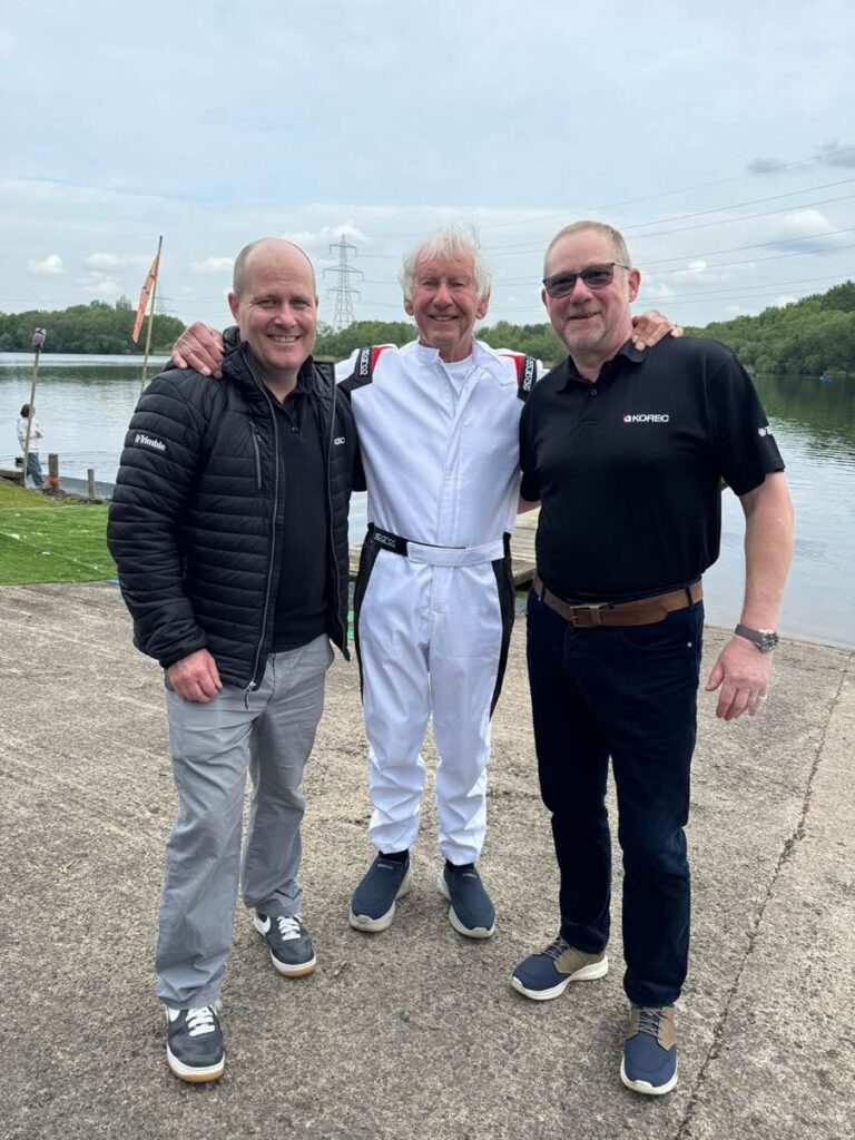
Rob, Tony and John
Achieving the world record
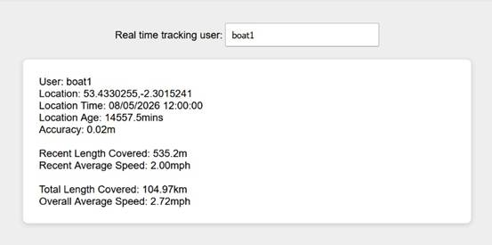
Success! Four world records were successfully achieved by Tony and the team and a huge sigh of relief came from the KOREC crew who’d had a fun but definitely stressful time to ensure that every contingency had been planned for in Tony’s very special attempt.
- Walking on water for 2 hours (longest continuous duration)
- Walking on water for 5 miles (longest distance in one continuous go)
- Walking on water for 24 hours (full endurance duration)
- Over 100 km walking on water (total team distance: 104.97 km / ~65.2 miles)
Progress was broadcast live via Soarvo
Over £30k was raised for the charity and Tony is already planning his next challenge. Find out more on Instagram @toneyfaheyofficial.
Please do make a donation to Make-A-Wish UK via Tony’s JustGiving page.
Technical take-aways
Soarvo is highly customisable for powerful and specific tasks with just a small amount of configuration that most can do.
Trimble Catalyst is extremely reliable and performs way beyond its price point functioning for 24 hours with no glitches or crashes.
Tony’s motivation
Tony’s challenge follows a near-death, life-changing accident in February 2021, when he was struck by a car travelling at 50mph while out on his daily walk. He sustained severe injuries that required emergency surgery and 18 months of intensive rehabilitation.
The Charity: Make-A-Wish
The challenge marks the first in a planned series of water speed and endurance record attempts, all designed to raise as much money as possible to help grant life-changing wishes for children living with critical illness. The charity is especially important to Tony:
“A few years ago, I met a young boy who was unwell. We talked about boats, record breaking speeds and my time on the water. He was fascinated by it all. I told him I wanted to help make one of his wishes come true.
I went back to see him again, hoping to take him with me on the water. I was an hour too late.
That moment has stayed with me ever since.
Make-A-Wish® UK helps create life-changing wishes for children living with critical illness, giving them and their families moments of joy, hope and precious memories when they’re needed most. Supporting this charity is very personal to me, and it’s at the heart of everything I’m doing now.”
Good luck in your future challenges Tony!
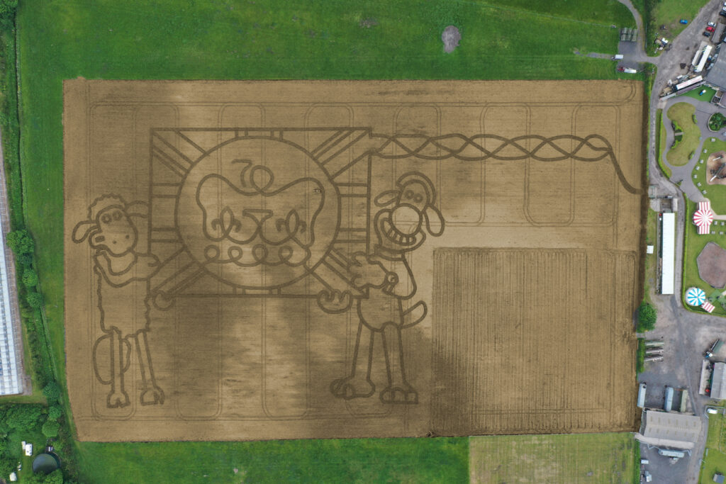
It’s taken permission from the Palace and the loan of one of the most advanced handheld GPS mapping systems available for Mark Edwards, Managing Director of Farmer Ted’s Adventure Farm, Ormskirk, Lancashire, to create this year’s jubilee themed maze attraction.
The maze was designed by Mark who enlisted the help of Liverpool based positioning and survey equipment specialists, KOREC Group. KOREC was delighted to loan him a handheld Trimble Catalyst GPS solution and also helped him turn the design into coordinates that could be loaded into the GPS to recreate the design in the maize field.
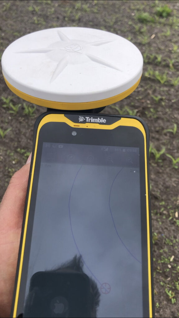
The Trimble Catalyst GPS connects to a smartphone that clearly shows the maze design. It is then taken onto the 14 acre maze site where Mark is able to navigate, using his position on the screen, to plot out the design amongst the tiny maize plants. A cultivator follows his trail cutting out the design.
Left:The KOREC supplied Trimble Catalyst GPS is capable of centimetre accuracy! This picture shows part of the design on a smartphone/logger
This year’s design comes with a royal seal of approval. Working closely with Aardman, the award winning animation studio and the creators of Shaun the Sheep, Mark contacted the Lord Chamberlain’s Office at Buckingham Palace and was granted permission to use the Queens official Platinum Jubilee logo to celebrate this great occasion!
Mark says, “the KOREC supplied Trimble GPS really is an ‘amaizing’ piece of equipment and so easy to use. We were able to create this exciting jubilee design in just 2 days!”
Farmer Ted’s is the UK’s largest Shaun the Sheep farm attraction. It opens daily until mid-September with the Maize Maze opening on 23rd July. Tickets can be purchased on-line at www.farmerteds.com
About Shaun the Sheep
Shaun the Sheep, Aardman’s family favourite TV series, is recognised the world over for its slapstick humour, distinctive look and strong, quirky characters and enjoyed across multiple media platforms. First appearing in Nick Park’s 1995 Academy Award® winning Wallace & Gromit ‘A Close Shave’, Shaun then went on to star in his own series, created by Richard Starzak which launched on BBC One in 2007. Shaun the Sheep is currently broadcast in 170 territories around the world and is an internationally celebrated icon with over 5.6 million fans on Facebook. In 2015 the first Shaun the Sheep Movie with feature film partner Studiocanal was released around the world to critical acclaim and the first half hour TV special aired as part of many broadcaster’s festive season., The feature film sequel Shaun the Sheep Movie: Farmageddon was released in October 2019 and nominated for an Academy Award® and was closely followed by a sixth season of the series in 2020. A new festive special Shaun the Sheep: The Flight Before Christmas was released in December 2021.
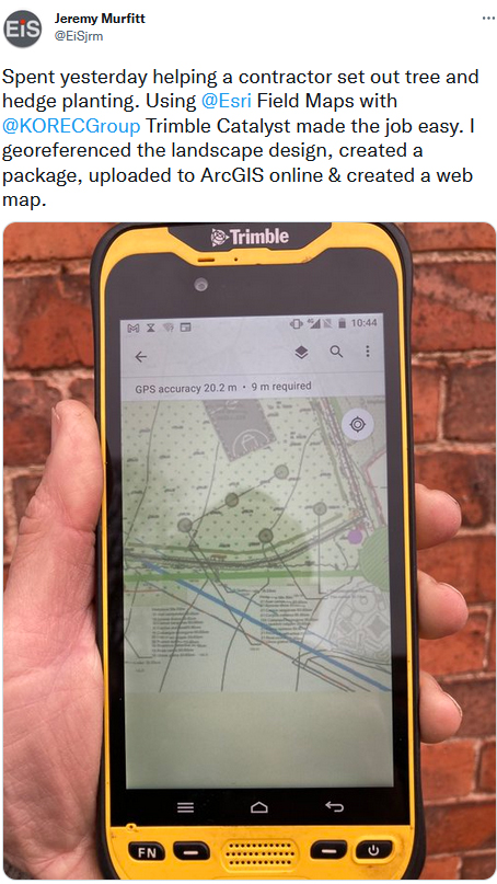
We catch up with Jeremy Murfitt, Owner of Everything is Somewhere, long time Esri user and an early adopter of Trimble Catalyst.
For many, Trimble Catalyst, our on-demand, low-cost subscription based GNSS, may be a relatively new concept, but the release of the DA2 receiver at the end of 2021 actually marked over three years of the technology. Back in 2019, one of Catalyst’s earliest adopters in the UK was Jeremy Murfitt Owner/Director of Everything is Somewhere Ltd (EiS). Jeremy has been doing a great job sharing details of his projects on Twitter, so much so, that we decided to follow up on one of his recent tweets to find out exactly why “Trimble Catalyst made the job easy”.
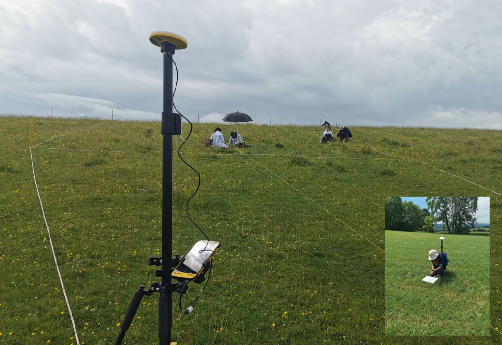
Based in Leicestershire, EiS is a consultancy practice specialising in a range of professional services on property and town & country planning matters.
The nature of these projects means that Jeremy offers a range of services including UAV surveys and field data collection both supplemented by his extensive GIS experience for understanding and analysing location and spatial data in various sectors.
For the field data capture and GIS work, Jeremy uses Esri software (KOREC is an Esri Silver partner) including Esri Field Maps on a Trimble TDC600 logger with Trimble Catalyst (cm accuracy subscription), Esri ArcGIS Pro and Esri ArcGIS Online.
A perfect combination – Trimble Catalyst, TDC600 and Esri Field Maps
Although already aware of KOREC and Trimble, Jeremy’s first view of Catalyst was at the Geo Business show in 2018 when he was searching for a more efficient and cost-effective method to capture cm positions rather than go through the obvious routes of the purchase or hire of a survey grade GNSS. As someone who required high accuracy positions as a part of his existing workflow rather than as his day in, day out work, Catalyst was an attractive proposition to Jeremy with its low capital outlay (around £300 for the DA1 receiver as opposed to around £8,000+ for a survey grade GNSS system), its ease of use and its fast set up.
Jeremy found it extremely easy to set up with his Field Maps software on the TDC600 logger and reports that it’s also incredibly fast to initialise in the field.
Can we swap?
Jeremy is using Catalyst for a number of applications including basic setting-out of new landscapes, and the recording of points for tree positions and utilities etc. However, his primary use is as a tool for establishing ground control points for the many drone surveys he undertakes. He reports that the 2cm accuracy he needs for flight heights of around 50-60m takes just a couple of minutes to achieve and that using Catalyst and Esri Field Maps he can establish the 5-10 GCPs, with two or three control points for each GCP, in just one hour if he’s walking at a good pace!
Whilst Jeremy particularly rates the system’s reliability and the fact that it hasn’t failed once since he purchased it, he says that its light weight and portability are particularly useful and that he can put the entire kit into his drone backback, something he particularly values when he can be walking around a mile to a site.
Meeting a land surveyor on one particular site who was fully equipped with a heavy tablet and full GNSS system, the surveyor was amazed to find that Jeremy’s system could achieve exactly the same results as his own. His response, “Can we swap?”
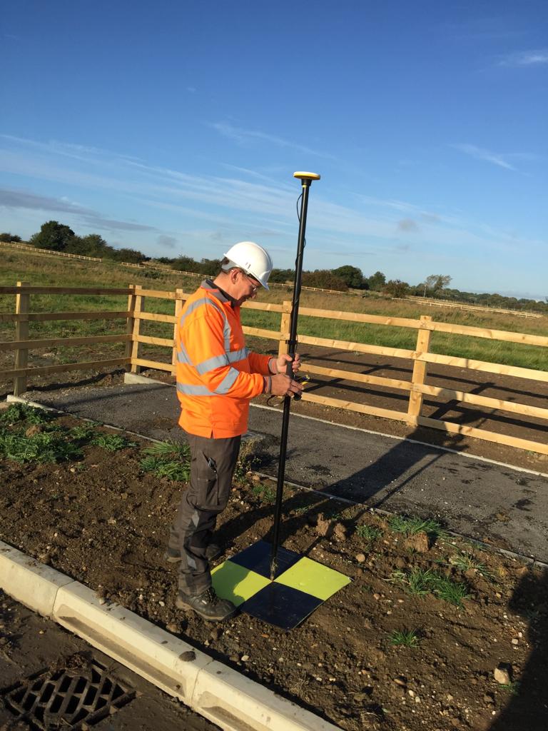
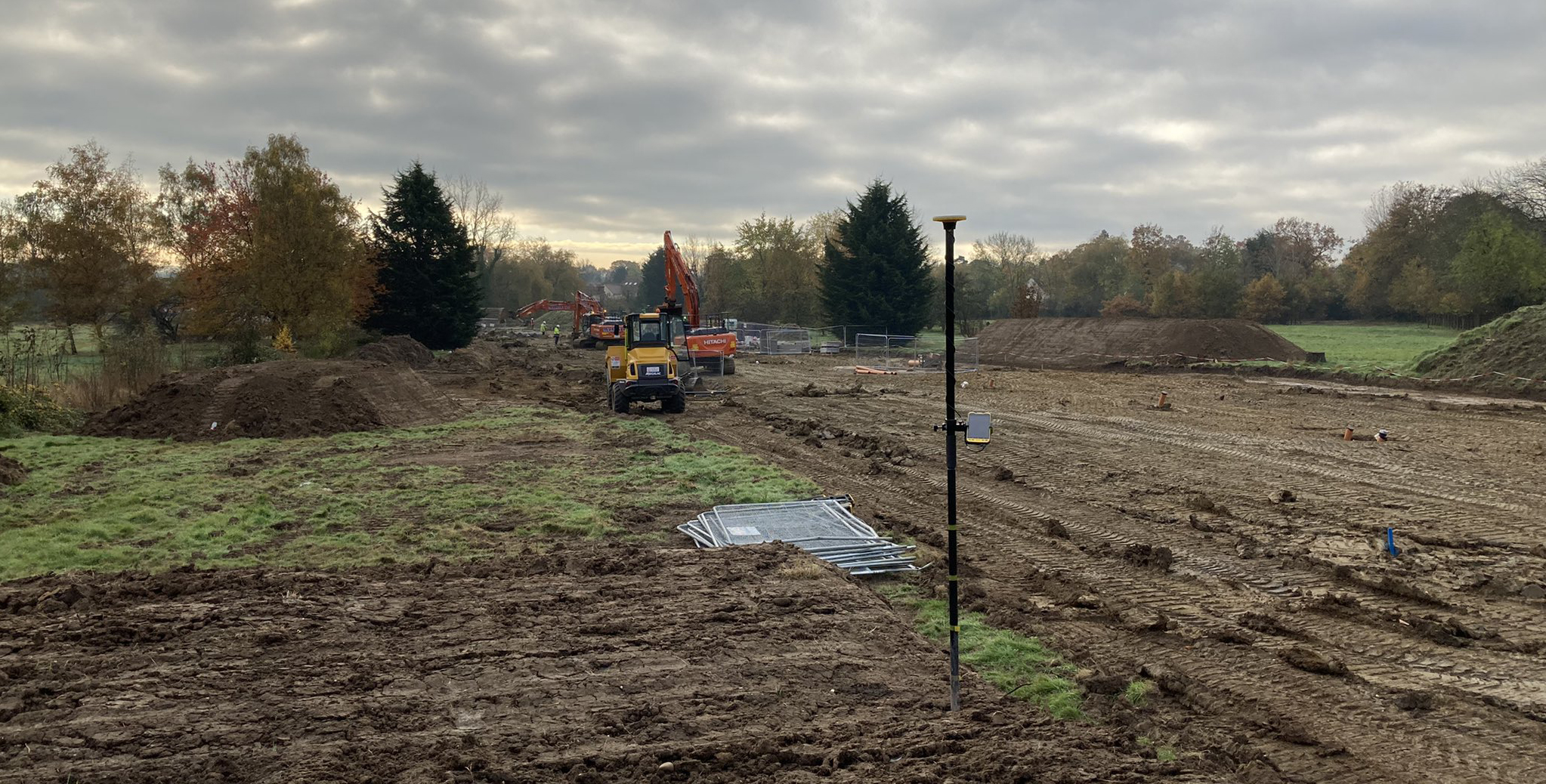
On site with Trimble Catalyst, the TDC600 logger and Esri Field Maps setting out Ground Control Points for a drone survey
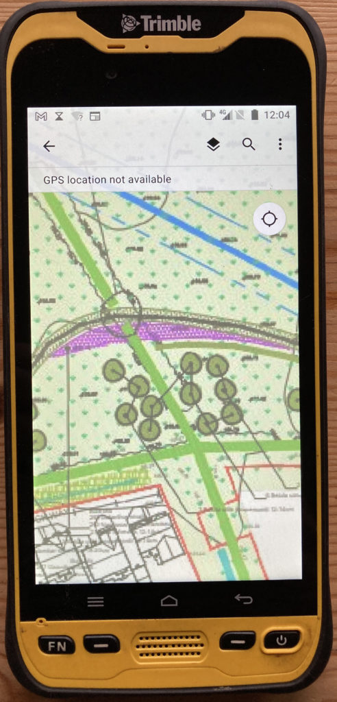
Setting out trees and hedgerows with Esri and Trimble Catalyst
On a recent job, Jeremy used his Catalyst, TDC600 and Esri software to assist with the setting out of around 150 trees and 500m of hedges as part of a new development in Leicestershire. Jeremy’s usual workflow has been to use point and line data provided by the landscape architect in CAD format which is easy to map and upload to ArcGIS Online and then use with Trimble Catalyst. However, the downside of this method is a loss of context and the detail that is shown on the large (A1/0) pdf drawings. Instead, Jeremy uses the original PDF’s, georeferences them and then uploads these to the Trimble TDC600 to use with Catalyst which he find particularly beneficial when in the field. A straightforward workflow that works well for this application, it took around 30 minutes to set up but saved a lot of time in the field:
- Convert pdf’s to tiffs/jpegs
- Import into Esri ArcGIS Pro and georeferenced
- In ArcGIS Pro “share” the images as a Webmap. You need to go to configuration and properties and check that the tiling scheme goes right down to level 23.
- Review the data in ArcGIS Online
- On your mobile device connect with Trimble Catalyst to get the required GPS accuracy
- Open the WebMap in Field Maps to set out the features.
Jeremy concludes, “I’ve been using Trimble Catalyst for over two years now and it makes capturing x/y/z data so easy plus it’s been 100% reliable. In short, it just works.”
Our thanks to Jeremy Murfitt, Owner/Director of Everything is Somewhere Ltd, for supplying the information for this article.
You can read a Trimble Catalyst business case here.
Download the PDF of this case study here
Visit our webinar section here for the full details on the new Catalyst system.
Congratulations to Atkins, the company that has been appointed by the government’s Geospatial Commission to help create a digital map of underground pipes and cables throughout the UK.
The map will be known as the National Underground Asset Register (NUAR) and is being developed by Atkins alongside mapping agency Ordnance Survey and geospatial data management leaders 1Spatial.
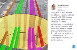
Designed to revolutionise construction and development across the country, the Geospatial Commission NUAR map release states that, “The economic cost of accidental strikes on underground pipes and cables is estimated to be £2.4 billion per year and one cause is inaccurate information on the location of buried assets. Once operational, NUAR is expected to deliver around £350 million per year in benefits by avoiding accidental asset strikes, improving the efficiency of works and better data sharing.”
The project is about to enter its build stage, a process estimated to run for three years. This is a large and ambitious undertaking, but the geospatial industry is highly progressive when it comes to the development and adoption of technology for field data capture and verification and the NUAR project will no doubt make excellent use of these developments.
Here at KOREC we can’t help but make three suggestions for technology that could be beneficial on a project of this nature:
Mobile Mapping + GPR Survey
The KOREC Professional Services team has just completed a roads project that saw them carry out a Trimble MX9 vehicle mounted mobile mapping survey at the same time as an underground mapping survey using Ground Penetrating Radar (GPR). This dual-purpose survey was completed with a single pass (reducing emissions and keeping boots off the tarmac) and produced a data set suitable for many applications from asset management to road conditions surveys to pre site risk analysis.
The Trimble® MX50, offered for sale by KOREC, is a practical field-to-finish mobile mapping solution for asset management, mapping, and road maintenance. The system delivers a very accurate point cloud of the environment along with complementary immersive imagery providing substantial gains in productivity in areas such highway management, utilities and local government.
Augmented reality

Imagine if you could see things that are hidden or that don’t actually exist yet. Trimble® SiteVision™ brings geospatial data to life so you can easily visualise, explore and understand complex information with unrivalled centimetre accuracy, right from your mobile device.
Ideal for use before and after in an application such as the NUAR project, SiteVision is proven technology used for the visualisation of underground assets by organisations such as Balfour Beatty Plc, O’Brien Contractors and the A14 Integrated Delivery Team.
Trimble SiteVision couldn’t’ be easier to use and is highly portable for use on site.
Centimetre accurate, low-cost positioning for large workforces
If you have a large workforce that requires centimetre positions to support its main line of work, then Trimble Catalyst provides an excellent way of enabling a varied workforce of non-surveyors to achieve the high accuracy that utility positioning requires, but without the costs of a high-end survey grade GNSS.
Trimble Catalyst is a revolutionary, GNSS concept delivering positioning as a service to mobile devices. It turns your existing Android or iOS device into a precision mapping, navigation and measurement tool that you can use with any location enabled app or service including KOREC Capture and Esri FieldMaps.
The cost of the Catalyst hardware has been kept low at just £300 per receiver and subscriptions come in a range of choices depending on the number of licenses required and hours used. However, Catalyst is more suitable for some users than others and our business case post on this is well worth a visit.
It’s also the perfect partner for our KOREC Capture Utility module for field data capture specific to the utilities sector.
If you’d like to find out more about any of these technologies, please contact:
Call UK Sales: 0345 603 1214
Call Ireland Sales: 01 456 4702
For anything else, view our contact page.
If surveying isn’t your main day to day activity but you still have a need for cm positions in your workflow, then the business case for Trimble’s Catalyst is a strong one.
Trimble Catalyst is a revolutionary, GNSS concept delivering positioning as a service to mobile devices. It turns your existing Android or iOS device into a precision mapping, navigation and measurement tool that you can use with any location enabled app or service including KOREC Capture and Esri FieldMaps.
The cost of the Catalyst hardware has been kept low at just £300 per receiver and subscriptions come in a range of choices depending on the number of licenses required and hours used.
However, Trimble Catalyst is not a solution for those who cite survey grade accuracy as the primary part of their working day. Instead, Catalyst has been developed for users who require cm positions as back up to the bulk of their work, for example, the scientist who needs to know precisely where a sample was collected, the utilities engineer who needs to position a valve or the knotweed removal specialist who must know exactly where the plant is located.
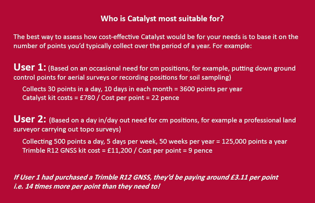
In short, the best way to assess whether Trimble Catalyst will provide the best value proposition for your cm positions is to base it on the number of points you typically over the period of a year.
Case study: DTM Technologies
Typical of the type of user who can benefit from the enormous savings Catalyst delivers is Owner/Director of DTM Technologies, Alan Roberts.
Established in 2014, North Wales based DTM Technologies offers a range of specialist 3D Structural and 3D Modelling Services capturing data predominantly through 3D Laser Scanning and drones. The company uses the very latest in data capture technology (Including the Trimble TX8 Laser Scanner) and provides the high resolution and accurate survey, mapping and environmental information that’s often used to form the basis of any construction (BIM), environmental or engineering project.
With the majority of Alan’s work requiring either a point cloud or aerial imagery, he has an important but fairly minimal need for cm positions. Six years ago, his approach was to purchase a survey grade GNSS system and a license for the corresponding annual correction service. However, he is quick to cite that he is not an engineer or a degree trained surveyor and during the years with this system, he found it expensive to use. As well as the up-front costs for the initial purchase of the hardware, he was also paying an annual correction service charge of around £1,200 p.a. – both large outlays. He therefore sought a solution that would better fit his requirements, spread the cost and offer better value overall.
Alan accordingly purchased a Trimble Catalyst receiver from KOREC and selected the subscription service best suited to his workflow from the options of 60 cm, 30 cm, 10 cm or 1 cm, in this case 1cm. The Catalyst antenna was compatible with his existing mobile phone, easy to set up and required no specialist positioning or GNSS knowledge for use.
The Business case in numbers
Alan states that in a standard working month he may carry out around four surveys that require cm positions and that he can capture the four or five points he requires plus a few check points in one hour of subscription time. He is therefore spending just £10 per site for cm positions, around four times a month. Based on those figures, with the subscription cost spread over a 12 month period, his annual running costs are £480.
| Previously | |
| Hardware: Initial outlay for GNSS system and controller (approx) | £10,000 |
| Annual correction service charge | £1200 |
| Now | |
| Hardware: Catalyst Receiver for use with Alan’s own phone | £300 |
| Subscription: On demand at £10 per hour based on typical annual use | £480 |
Upfront hardware savings ≈ £9600
Annual running cost savings ≈ £760 p.a.
As an experienced user of Trimble Catalyst, even Alan still believes that that system is almost too good to be true. “With Trimble Catalyst, achieving cm accuracy in the field is no longer a niche occupied only by land surveyors, often with the price tag to match. Previously, I was pretty well priced out of the market for this level of accuracy but Catalyst really does bring high cm positions to a mass audience. I’m now in a good position to pass my savings on to my clients which definitely helps in a competitive marketplace.”
Next steps – the new Catalyst DA2
Alan was an early adopter of the Trimble Catalyst system and is already assessing the recently released DA2 receiver.
With much of his work in Snowdonia, mobile phone reception is often compromised and even taking three different SIM cards doesn’t always guarantee a successful connection. The DA2 comes with RTX corrections which means he will no longer be reliant on receiving his cm corrections over an internet connection. Thanks to Trimble’s RTX technology he will be able to get his corrections via satellite.
In addition, the DA2’s ProPoint technology will enable him to pick up his positions in challenging GPS conditions such as near tree canopy.
You can read about our DA2 test here.
A related case study on knotweed mapping with Catalyst is here and asset data collection here.
Visit our webinar section here for the full details on the new Catalyst system.
We’d like to introduce you to a new acronym – PAAS or Positioning as a Service!
The DA2 is the second-generation receiver and antenna for Trimble’s Catalyst service. Simply, Catalyst is a revolutionary, GNSS concept delivering positioning as a service to mobile devices. It turns your Android or IOS device into a precision mapping, navigation and measurement tool that you can use with any location enabled app or service including KOREC Capture and Esri FieldMaps.
Catalyst delivers the most cost-effective method for achieving cm accuracy positioning in the industry.
Subscription based services have grown faster than traditional businesses in many areas of the economy. Trimble is leading the way in PAAS with its Catalyst positioning service.
Of course, here at KOREC we don’t just take things at face value so our Mapping Business Area Manager, Richard Gauchwin, has been out and about putting the DA2 through its paces.
We caught up with him to find out what’s new and what’s impressed. Here’s his verdict:
- Number one has to be the fact that the DA2 is now a full GNSS receiver which removes dependencies on the mobile device which you may have seen with the DA1.
Whilst the DA1 connected via a cable into an Android phone, it was the app on the phone where all the GNSS processing was carried out. In short, processing times etc were limited by the phone’s performance. Not so with the DA2 receiver, it’s a whole different story! The biggest plus is that Catalyst is now so much faster to use. For example using the DA1, it might take you minutes to get a position, with the DA2, we’re talking seconds!
They may look the same and still weigh in at just 330g, but in terms of performance they couldn’t be more different.
2. The DA2 brings you far more flexibility as it now has Bluetooth which allows you to connect wirelessly to your mobile device of choice. And believe me, there is definitely more choice because this now means that the DA2 is compatible with both IOS and Android.
3. The DA2 offers Trimble’s ProPoint technology which has previously only been available in top of the range GNSS receivers. ProPoint means better results in harsh GNSS conditions, for example near tree canopy and in built-up areas. Expect a cm position near tree canopy within 40 seconds.
4. New subscription choices mean even better scalability. Subscriptions have been clarified to accommodate the better accuracies achievable. Choose from 60cm, 30cm, 10cm or 1cm. Trimble have also provided more choice in the number of hours you can purchase including some great options available for equipping large workforces. And of course, you still only pay for what you use.
5. The DA2 means that you are no longer reliant on receiving your cm corrections over an internet connection. Thanks to Trimble’s RTX technology you can now get your corrections via satellite which is great for areas with limited mobile phone coverage and internet connectivity.
6. The DA2 is future proof and will update wirelessly when required.
Who is Catalyst suitable for?
In a nutshell, we describe Catalyst as being a truly cost-effective option for those who require high accuracy positions as a part of their workflow, for example, positioning Ground Control Points for an aerial mapping project, recording the location of soil samples on a construction project or positioning valve or pipe connections on a drainage job. By having access to a cm accuracy system, with no training costs and no outlay for expensive, specialist hardware, Trimble Catalyst is truly a system that can put cm accuracy into the hands of the many different users and/or across large workforces.
We have a great analogy comparing Catalyst to a buying a printer and printer inks. Simply, the hardware costs in buying a printer are minimal, the service, or in this case the printer ink is where the cost lies. If you are just printing out two or three pages every now and again then this is the equivalent of a Catalyst user who can really gain value from the system. If however, you print off many full reports every day, then you will not achieve good value from Catalyst and it’s best to consider a dedicated survey grade GNSS.
If you’d like to see which KOREC customers been using Catalyst then please visit our customer story blog here to read about:
· V.T.O.L Media – establishing ground control points for aerial surveys
· 3LM – a holistic approach to agriculture and the land
· TP Knotweed – rapid response identification and removal of knotweed
· A14 Integrated Deliver Team – fast one-off positions and augmented reality in the field
A related case study on knotweed mapping with Catalyst is here and asset data collection here.
Visit our webinar section here for the full details on the new Catalyst system.
Who needs low cost, on-demand, cm precision data collection?
“A cm accurate GNSS solution at the right price point.” Christopher Cooke of 3LM on Trimble Catalyst
We’ve just launched ‘A Grand Deal’ and it’s our offer of the summer! Mobile, on-demand data collection with centimetre-precision, our KOREC Capture data collection app and the KOREC Portal for review, analysis and reporting of data, all for under £1,000.
Key to this very grand offer and the exceptionally low-priced cm precision is Trimble Catalyst, our on-demand subscription based GNSS. Easy to set up and use, with a range of accuracy subscriptions available, the only hardware you need to purchase is the low-priced antenna.
But who can benefit from this offer? We took a look through our list of Catalyst users and the range is vast! Here are just some of the examples of KOREC customers who have selected Catalyst for their projects (full stories below):
V.T.O.L Media – establishing ground control points for aerial surveys
Operating out of Shropshire, V.T.O.L Media is a company that specialises in aerial photography, video and survey and in particular, construction monitoring. The company is owned by CAA Approved drone pilot, Neil Pepper, who has a mixed drone fleet and takes great pride in using only the latest in high-tech equipment.
The company has recently experienced an increase in demand for survey work with many clients requesting high accuracy aerial surveys. Aware that the use of ground control points would greatly improve the accuracy of any aerial surveys he undertook, and with many of the projects he was working on having little or no established GCP’s, he decided that the ability to establish his own would ensure total confidence in the accuracy of any aerial surveys he carried out.
Having researched various options for the precise positioning of chequer boards in wide open spaces or drains, road markings etc in urban areas, he found a perfect match for his requirements in Trimble Catalyst. Light, easy to use, compatible with his Android smartphone and by far the most cost-effective cm accurate system he could find, Neil says that he can place his GCP’s in under and hour and the cost of his Catalyst cm on-demand subscription is just £10!
3LM – a holistic approach to agriculture and the land
Yorkshire based 3LM is a member of the Savory Network, a global group that advocates, trains and supports land managers around the world to regenerate land through Holistic Management. 3LM specialises in the provision of educational and advisory services to agriculture and works with farmers who know that something needs to change, but are unsure what. Assisting this approach to change is the precise measurement and data capture of the four eco system processes fundamental to all life – water, minerals, solar energy and community dynamics.
3LM Company Director, Christopher Cooke has a strong background in both GNSS and water management and therefore turned to KOREC in his search for a cm accurate GNSS solution at the right price point. Finding the suggested Trimble Catalyst solution exceptionally easy to use and subscribe to, the company now has two systems comprising Trimble Catalyst, TDC600 logger and KOREC Capture field data capture software.
“The Trimble Catalyst system couldn’t be easier to use. It’s reliable, easy to subscribe to, and most importantly I know that our data is secure with zero chance of it being lost due to storage in both the cloud and on the TDC600. Having cm accuracy on demand allows us to accurately position any areas that we sample from and then navigate back to them at a later date for progress reporting. Additionally, the data management side of the system, developed by KOREC, really is world class.
“We have now achieved our aim of being paper free in the field and have particularly enjoyed how this technology has captured the imagination of the younger generation of farmers and land managers that we work with.”
TP Knotweed – rapid response identification and removal of knotweed
Aggressive, destructive, relentless, Japanese Knotweed is the most invasive plant in the UK and remains a major problem for the construction industry. One company specialising in its removal is Oxfordshire based TP Knotweed, a company that is prepared to invest in technology in order to increase efficiency, whether that be CRM, van trackers or new apps, or in this case Trimble Catalyst.
When TP Knotweed takes on a project, it’s vital that they have very accurate measurements as to the area of an infected site if they are to prepare an exact quote for their clients, along with a map of the project including the position of any boundaries, stockpiles trees etc.
For smaller sites, their solution was a Trimble Catalyst subscription for cm accuracy along with KOREC Capture software which could run on one of their existing Android smartphones or tablets.
TP Knotweed found the Catalyst system quick to set up and easy to use making it ideal for fast turnarounds on these sites. The company also reports that the systems are in use every day and that the quality and quantity of information they are collecting is proving vital for another of the company’s aims, to build a UK wide shareable database of knotweed contamination.
A14 Integrated Delivery Team – fast one-off positions and augmented reality in the field
The £1.5bn A14 Cambridge to Huntingdon improvement scheme was one of Highways England’s largest recent projects and the 34km site provided the contractors involved with a perfect testing ground on which to share new ideas and balance tried and tested technologies alongside new ways of working.
For Skanska’s Mark Lawton, Chief Engineering Surveyor, A14 Integrated Deliver Team, Trimble Catalyst provided two useful areas of investigation for potential use on future projects:
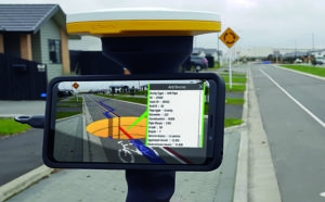
1. Contractors on the A14 scheme often required accurate positioning in ‘one off’ situations. For example, those carrying out borehole testing or soil sampling needed accurate positions either to map a new point or navigate back to a previously recorded one. However, it would not be cost-effective to send a fully trained engineer with survey grade GNSS to carry out these tasks. An obvious alternative was Trimble Catalyst, in this case using its on-demand subscription model with KOREC Capture data collection software running on the contractor’s smartphone. KOREC Capture could offer the contractors fully customisable lists, drop down boxes, mandatory fields etc which again would bring consistency of data, to the attribute information collected as well as cm positioning.
2. Mark also successfully trialled Trimble SiteVision, a system that fuses cutting-edge augmented reality technology with Trimble Catalyst centimetre-precision GPS. The end result is a system that allows you to take your models, drawings and data off the screen and onto your site. Key application areas included utility records, design information, future information and 3D models. In particular, Mark mentioned that on the A14, following the capture of hundreds of km of cable, they needed to know exactly where that cable was for a Permit to Dig. Having the information available visually through SiteVision was hugely helpful in determining where they could excavate.
Additionally, he says that SiteVision provides an easy to understand visual explanation to third parties, such as householders, as to why they are digging in a certain place.
What’s Next?
Take a look at the Trimble Catalyst product page
Watch the official Trimble Catalyst video on our YouTube channel
Make sure you follow KOREC Mapping for all the latest news, info and events
Eight points to consider. “Will we continue to use it…oh yes.”
During this year’s GEO Business show, Skanska’s Mark Lawton, A14 IDT’s Survey Manager, shared some thoughts on Trimble SiteVision based on Highways England’s A14 Cambridge to Huntingdon improvement scheme trial.
Chaired by Mark, the show’s Wednesday Highways Seminar was a critical session for all involved in highway infrastructure. As part of this workshop, Mark gave a talk entitled “An A14 update on the recent trial of mixed reality – what have we learnt so far?” With the launch of Trimble SiteVision now imminent, this was especially topical.
At this stage, Mark was just four weeks into a six month trial but his first point was key – if you are to use Trimble SiteVision to its full potential then you need good data. Accuracy was also checked and Mark reports that in focused tests, SiteVision was delivering 50mm accuracy.

Checking accuracy
Key application areas included utility records, design information, future information and 3D models. In particular, Mark mentioned that on the A14, following the capture of hundreds of km of cable, they needed to know exactly where that cable was for a Permit to Dig. Having the information available visually through SiteVision was hugely helpful in determining where they could excavate.

Clearly showing pipe locations
Additionally, he says that SiteVision provides an easy to understand visual explanation to third parties, such as householders, as to why they are digging in a certain place.

Alison Small (Engineering Surveyor, Skanska) walked the route with SiteVision explaining how the design will miss these trees on the A14 C2H project
Mark’s conclusions following four weeks into a six month trial:
- Easy to use
- Adoption and take up has been welcomed
- The workforce have recommend improvements that are realistic, for example, video screen capture.
- Requires good BIM/Data
- Multiple opportunities for customer briefing
- Will aid success in reducing services strikes
- Expect to wait a little longer to establish GNSS lock with Catalyst than with a high end surveying GNSS
- “Will we continue to use it…oh yes.”
Trimble SiteVision fuses cutting-edge augmented reality technology with Trimble Catalyst centimetre-precision GPS (now available on-demand) to bring your 3D designs off the screen and onto your site.
GeoConnexionUK has also used its May/June issue to highlight how the exploitation of two very different Trimble technologies (The R10 and Trimble Catalyst) can be used in the fight against the invasive plant, knotweed. In our ‘Whacking the Weed’ article, written with Tom Goodman of TP Knotweed, we outline how TP Knotweed’s take up of GPS is just part of its overall commitment to IT and innovation – a strategy that drives the company and is a great example to many other industries.
Who would use centimetre accuracy on a smartphone and what would this innovation mean for the geospatial industry?
At the end of 2016 we found ourselves asking these questions following the announcement of the world’s first software GNSS receiver, Trimble Catalyst. These are also the questions that KOREC’s Business Area Manager for Mapping & GIS, Richard Gauchwin, sought to answer in his article in the January issue of CES. In this piece Richard identifies the five key user groups that we have seen emerge since the launch of Catalyst:-
Who will use cm accuracy on a smartphone and what does this innovation mean for the geospatial industry? At the end of 2016, we found ourselves asking these questions following the announcement of Trimble Catalyst, the world’s first software GNSS receiver. Catalyst has been designed to run on Android phones and tablets and when used in conjunction with a small ‘plug and play’ low cost digital antenna, it turns these devices into cm accurate data collection tools.
Trimble Catalyst represents a new era of GNSS technology and a new business model – software as a service (SaaS). It’s available as an on-demand subscription service and offers a range of accuracies from 1m to centimetre level, priced accordingly. In short, it puts affordable, cm accuracy into the hands of any industry in the world that uses smart phones which I believe is pretty well all of them!
The ethos behind Catalyst is threefold; to make GNSS more accessible by adding a whole new level of functionality to a tool almost all of us have in our pocket, the smartphone; to make GNSS more accessible by removing complicated set ups involving base stations; to make GNSS more accessible by simplifying the delivery of the service.
Of course, the ubiquity of the smartphone and its enhanced processing power has been key to the timing of Catalyst as has the on-demand economy that continues to shape customers’ expectations in many business areas including the geospatial industry.
In terms of development, key requirements for any technology aimed at a broad user group are likely to include ‘small’, ‘light’, ‘user-friendly’, ‘accessible’ and ‘affordable’. Combine these elements and we have a list of the drivers behind Trimble Catalyst.
The Catalyst business model
It’s important to understand that the Catalyst business model is not the solution for every application that requires cm accuracy. My advice would always be to start with the workflow. For example, if the requirement is for accurate positioning on a project basis, then Catalyst would be a good option for short term use as an operating expense. It’s also ideal for a larger and broader user base where workflows could benefit from high-accuracy positions but the data collection is not the primary function of the workforce.
For large roll outs on contracts, the advantages of a software GNSS receiver can be immediate. Most people already have an android smartphone so the only required accessory is the lightweight, low priced digital antenna. No GNSS hardware is required because Catalyst is a software-defined GNSS receiver and users subscribe to the level of accuracy needed, centimetre, decimetre, sub-metre or metre, from a range of options priced from £35 per month.
As I mentioned earlier, simplicity was one of the driving factors in the development of Catalyst. On startup you just plug in the Catalyst antenna, select the best available correction service based on location and subscription level and off you go. But ease of use will also depend upon the choice of data capture software. We predict that the developers of this type of software will continue to work on making their solutions even more intuitive to the non-expert, to the extent where training can be cut to just an initial short phone call, again reducing project costs.
The expectation is that this type of technology and business model will extend the accessibility of high accuracy positioning way beyond the ‘core’ of geospatial users already familiar with it and into the hands of anyone who wants to collect accurate special intelligence. However, Trimble Catalyst has only been available in the UK since July 2017 and as yet, the data collection apps it is compatible with are recognisable names from the industry, Trimble’s Terraflex, KOREC’s K-Mobile and Esri’s Collector App, all developed for general field data collection. However, Trimble’s downloadable software development kit (SDK), means that we are already starting to see companies with existing apps looking to integrate them with Catalyst. This will provide an interesting indicator as to who is really making this technology work for them. Early developers include a company specialising in the precise positioning of trip hazards on pavements and a construction company with an augmented reality solution that places digital objects into the view of the physical world.
Early adoption and the emergence of key users
Based on the last 5 months we are seeing clear indicators as to where the interest in this type of SaaS lies. Although it’s early days, we can broadly group those taking up the technology into five different types of user.
Users for whom affordable cm accuracy can greatly enhance their day to day business but cannot justify the expense of a dedicated high accuracy GNSS receiver or the cost of sporadically having a surveyor or second team on site. Top of this list has to be the drone operators we work with who wish to establish ground control for their aerial mapping projects. Ground control increases x,y,z accuracy which enables a project to be scaled in all three axes and allows users to add value to their offering through accurate 3D measurements. Ground control also ensures correct geo location of the surveyed site by tying into the OS Grid. Previously the expense of buying a GNSS to deliver the cm accuracy required for establishing ground control would have cost more than the drone itself. This simply would not be viable for a ‘value add’ to an existing service.
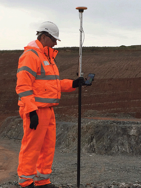
Using Trimble Catalyst for UAV ground control points at a UK quarry site
Also falling into this group is a customer that specialises in pipelines and wished to close the gap between expected compliance and what really happens on site. Previously this customer was taking georeferenced photos and recording relevant positions, such as pipe valves, for QA purposes just using a standard mobile phone. However, the lack of accuracy with this system meant that pipes could be located on the wrong side of the road or even in people’s gardens. Catalyst has provided a low-cost solution that has elevated their QA reporting to a new level allowing them to provide accurate digital plans of their work.
Users who already understand and use high accuracy GNSS but require additional systems for carrying out ‘irregular’ surveys. Typically, any large civil engineering project in the UK, whether it be roads, rail or building construction will see an onsite team of busy survey professionals undertaking a range of surveying tasks from setting out to as-builts, all on a daily basis. Supporting the main task will be other smaller teams, vital to the smooth running of the project, but with little or no survey experience, for example, those carrying out soil analysis or borehole sampling. Whilst it’s vital to have an accurate location for a test area or borehole if you are to navigate back to them, especially in overgrown areas, it’s not something that a major contractor would want to commit survey resources to.
Additionally, much of our new SaaS business is with utility companies including one responsible for creating manhole cards. This company’s field workers are recording lots of attribute information including manhole location, cover shape, chamber size, ladder position and pipe direction and diameters all backed up by photographic evidence. However, all this attribute information needs to be attached to an accurate position for the presentation of a complete condition report.
Users who have never used cm accuracy before and have no survey experience. A great example in this area is a company we’ve been working with that specialises in designing and installing agricultural irrigation systems. Previously, they would install a system and simply record all the information relevant to the installation using pen and paper. Now, for the first time, they can access cm accuracy on their mobiles and position all the information they need to create an accurate plan of what’s been installed, the pipe levels, direction of flow etc – vital information for the maintenance and development of each customer’s system whilst adding value to their own proposition.
Users who require on-demand cm accuracy as part of a fully customised solution where position is just one piece of the puzzle. Our KOREC software development team works in partnership with many companies advancing and tweaking their data capture systems to fit a specific workflow. Already we have customers coming to us for whom Catalyst is the starting point for a fully customised system. A useful example here is the testing companies that we’ve been dealing with. Responsible for testing things such as lighting columns, masts or signalling equipment, it’s their job to ensure a column’s safety and to establish when it may need replacing. Previously the test results, documentation and evaluation for this process were all recorded on paper. Testing companies have come to us with a view to digitising the process and are now using Catalyst to provide the cm accuracy of the column positions in conjunction with customised KOREC K-Mobile software for the collection of the required attribute information. The KOREC system also automatically bundles this information into a pdf report for immediate transfer to the office. This means that those responsible for the safety of the assessed columns can react to failed tests immediately and located the correct column without delay.
Users we could never have predicted! I mentioned at the beginning of this piece that the Trimble Catalyst business model puts affordable cm accuracy into the hands of any industry in the world that uses smart phones and believe me, that really could mean any industry at all! We can’t wait to see how people take up this technology and we are already receiving some interesting feedback courtesy of the Ordnance Survey’s GeoVation Hub which was the recipient of a Trimble gift of Catalyst licenses. The Hub is home to a group of innovators ranging from Big Data users providing insurance risk analysis for drone flights to the makers of collaborative real-time infrastructure planning tools. We’re already hearing reports of Catalyst being used with ground based drones. Watch this space!

Kerb line surveyed to 1cm accuracy using Trimble Catalyst shown on Ordnance Survey Mastermap
An evolving technology
Catalyst will continue to develop and this evolution will be led by customer demand. Indeed, we are already seeing this with the arrival of GLONASS signals for even better coverage in challenging areas such as city centres.
Trimble is aware that services such as ‘pay per view’ shape customers’ expectations in our markets which may make other subscription options a possibility. Catalyst for iOS is another development which would fit into the Trimble customer business process. Finally, Trimble is also actively seeking third party developers wishing to integrate their applications with Catalyst, something underlined by its gift of licenses to the Ordnance Survey’s Geovation Hub. This new generation of users is also likely to shape the future of Catalyst.
In conclusion, by putting cm accuracy into the hands of those outside traditional geospatial business areas we can expect further progress in the democratisation of data as it becomes more usable and more understandable by more people. This will allow many businesses to expand away from being just data providers to service providers adding a whole new level of value to what they do and what we as an industry can offer. Who knows where the combination of low cost cm accuracy and open access will lead us and I for one can’t wait to find out!