Exeter underground – surveying the city’s hidden history
A request to survey a 390m network of Exeter’s historic underground tunnels - some as narrow as 430mm - and to tie those tunnels to the topography of the streets above, presented exactly the kind of complex, technical challenge that Benchmark Surveys excels at.
A request to survey a 390m network of Exeter’s historic underground tunnels – some as narrow as 430mm – and to tie those tunnels to the topography of the streets above, presented exactly the kind of complex, technical challenge that Benchmark Surveys excels at.
This remarkable heritage project was delivered successfully through the use of a fully integrated Trimble workflow.
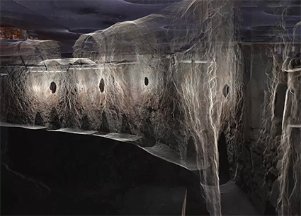
As the people of Exeter pass about their daily business along the streets of the city, most are unaware that beneath their feet, in some cases just 710mm beneath, a network of historical tunnels, dating back to medieval times, runs through the area.
Constructed primarily in the 14th century, these passages were designed to house lead pipes that transported fresh drinking water from natural springs nearby into the walled city. A fine example of the advanced engineering of the time, the tunnels allowed for easier maintenance and repair of the pipes without the need to dig up streets. Since then, the passages have been historically important to many major events associated with the city, from wars to sieges, and are the only ones of their kind open to the public in the UK.
Documenting the past
For Exeter-based Benchmark Surveys, a family-owned business with strong local connections, the task of creating a highly accurate floor plan of all the tunnels – and placing them in context with the topography above – has been both professionally and personally rewarding, especially for the company’s Director, James Richards.
The initial brief from Exeter Council was to capture both 2D and 3D data of the tunnels, enabling the production of sectional drawings, a floor plan, and a DWG-format topographic survey.
Topographic survey first
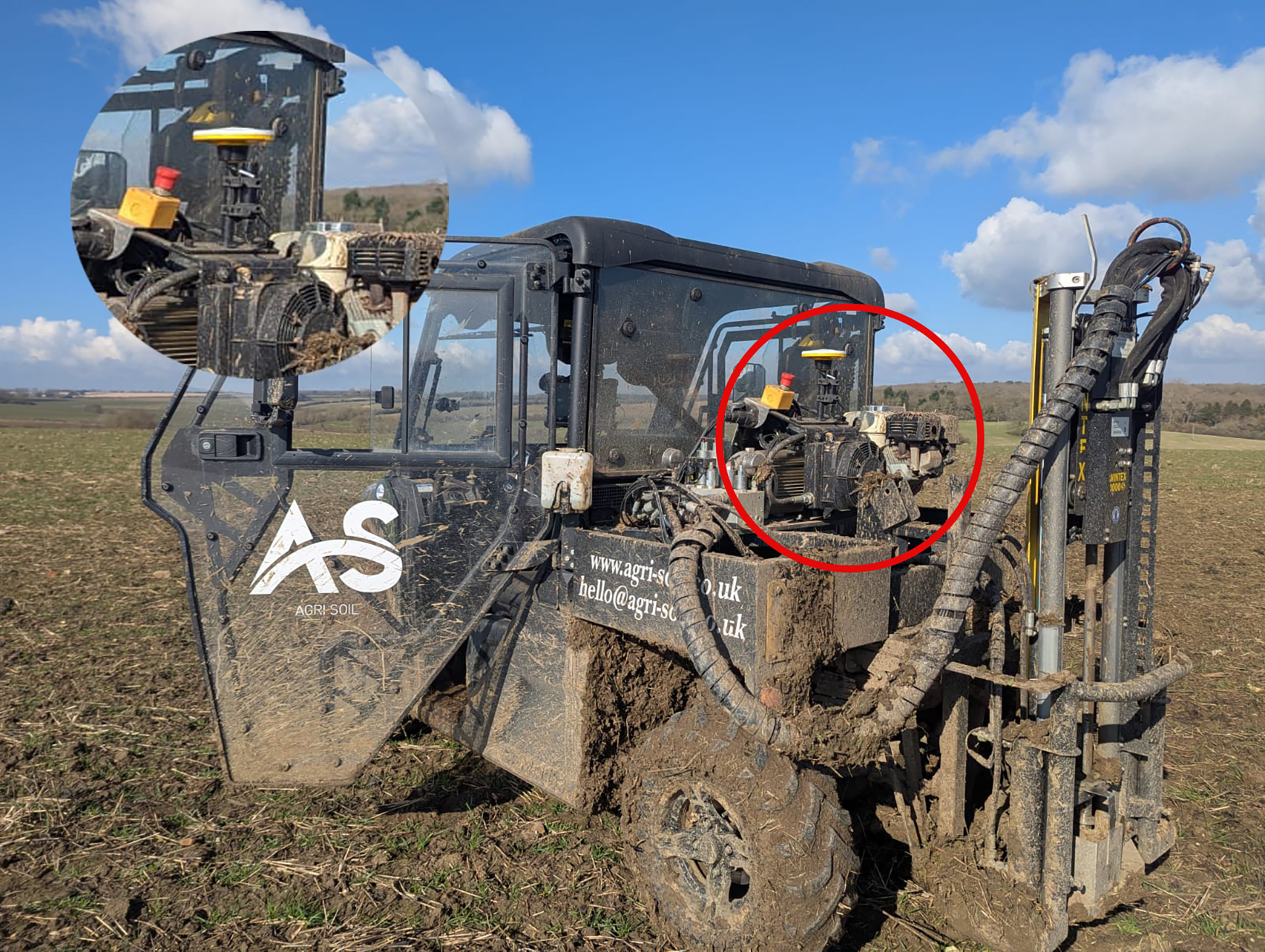
Above the ground, Benchmark’s Trimble R12i was used to establish position and also the longest baseline with which to tie the site together. The team then switched to a traverse kit with a Trimble S9 0.5” angular accuracy total stationto create a really tight control network which would minimise the drift of the laser scanner in the tunnels. Extra attention was therefore paid to the areas where they could connect the topographic survey with the tunnel survey at four separate sites. These sites – two tunnel exits, a manhole cover and access via a shopping centre – were scanned using a Trimble X7 3D Laser Scanner.
At the manhole site, the X7 was used on an inverted tripod to link the above and below ground surveys. All the topographical work was completed in less than three days.
Three challenges: Overcoming drift, tunnel width and low light
Having carefully assessed the tunnels, James and Benchmark Surveys lead Measured Building Surveyor, Anthony Drew felt that the only way to tackle a linear project of this complexity was through the creation of a 3D laser scan. However, they were already aware of a number of site challenges that would rule out using a SLAM system and even prove exceptionally demanding for most 3D laser scanners. They therefore opted for the KOREC supplied Trimble X12, Trimble’s highest performing scanner that ticked four vital requirements for this project:
Crisp, clean data delivered with high accuracy and precision (0.30 mm range noise @10m)
Compact form factor and low weight for easy manoeuvrability within the tunnels
Minimum measurement of 300mm for scanning successfully in the narrowest areas
Built-in LED spotlights for illuminating the passageways
Drift: This was the primary concern for the Benchmark team with the tight above-ground traverse leaving minimal tolerance for error. To accurately position the tunnel in relation to the surface topography, a precise and stable spatial connection between the surface control network and the tunnel survey was essential.
The high-quality control established above ground with the Trimble S9, provided the necessary accuracy to mitigate drift and ensure reliable alignment of the tunnel data which would be of the highest quality courtesy of the X12’s accuracy and precision.
Tunnel width: Throughout the 390m network of tunnels, width ranged from between 930mm to just 430mm, sometimes with just 800mm clearance, making use of a tripod impossible. The X12 has a minimum measurement of just 300mm and was therefore used on a trig plate with James reporting that as well as capturing every detail, it was even able to record the screws on the corners of the plate.
Light: Although the Benchmark team could have taken lighting into the tunnel, this was not necessary thanks to illumination from the X12’s four LED spotlights for impressive, shadow-free image capture, bringing the dark spaces to life with rich, accurate colour.
Over a two-day period, 131 scans were undertaken capturing the entire tunnel network including manholes and doorways along with key architectural detail. This fitted perfectly with the 243 scans connecting the modern structures above.
Another challenge: Processing the linear data
Back at the office, Trimble RealWorks was used to process the scan data. For James and Anthony the challenge was finding a way to manage a high number of linear scans, especially as a traditional ‘cloud-to-cloud’ approach was unworkable because the scans were so close together that accumulated error would become a problem. Instead, the data was divided into manageable sections (e.g. 1–5, 5–10), and this simplified method was used to define the structure’s shape. These sections could then be infilled and refined to minimise errors between them.
James reports that, thanks to careful planning, this complex project was relatively straightforward to complete due to the seamless integration of the various Trimble hardware and software systems used. These included the R12i GNSS, the S9 Total Station with onboard Access software, the X7 and X12 3D Laser Scanners with Perspective software, and back at the office, RealWorks for scan data processing and Trimble Business Center for survey data processing. All worked together seamlessly.
Adding value
James concludes, “To be part of such a historic project in our hometown has been extremely rewarding. We’re proud to have created something that far exceeds what was already in existence and hopefully create our own bit of history with this amazing dataset.
“Having successfully captured so much high-quality 3D data, we wanted to go a bit further for the client and produce a truly awesome video of the tunnel network. Joshua Rogers has created a fantastic visualisation on YouTube, exactly how I envisioned the network would look at the beginning of the job. It’s also been great to see the client appreciating how much potential this survey has for both present and future plans for the tunnels.”
How a strong understanding of the Exyn Nexys SLAM technology enabled SYSTRA UK to strike the perfect balance between speed and accuracy during a recent structural assessment survey of a...
A family farm has diversified into providing an expert soil sampling and analysis business as an independent alternative to using services provided by large agricultural chemical companies.
Growing a business through clarity: How Image Surveys used Soarvo, a cloud-based 3D geospatial platform, to make 3D drone data interactive and easy to share for all of an events...