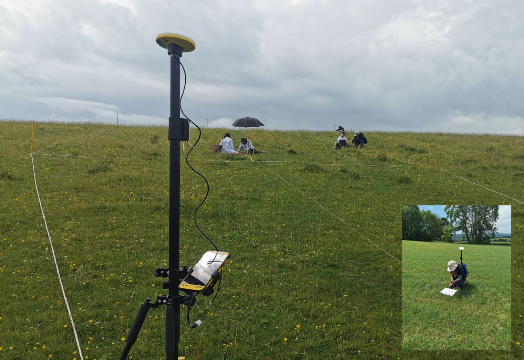
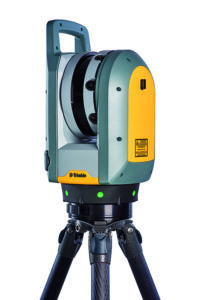
When Trimble launched its newest 3D Laser Scanner, the X7, the company clearly stated that its aim was to create a laser scanner that truly addressed the pain points of every user who wished to capture a high-quality point cloud quickly and efficiently.
What better way to find out if they succeeded than with some simple market research? We shared our poll with thousands of you via LinkedIn and the Laser Scanning Forum in our efforts to discover the biggest bugbears with your current scanning set up, asking you to select from four options or add your own in the comments section. And the results are in…….
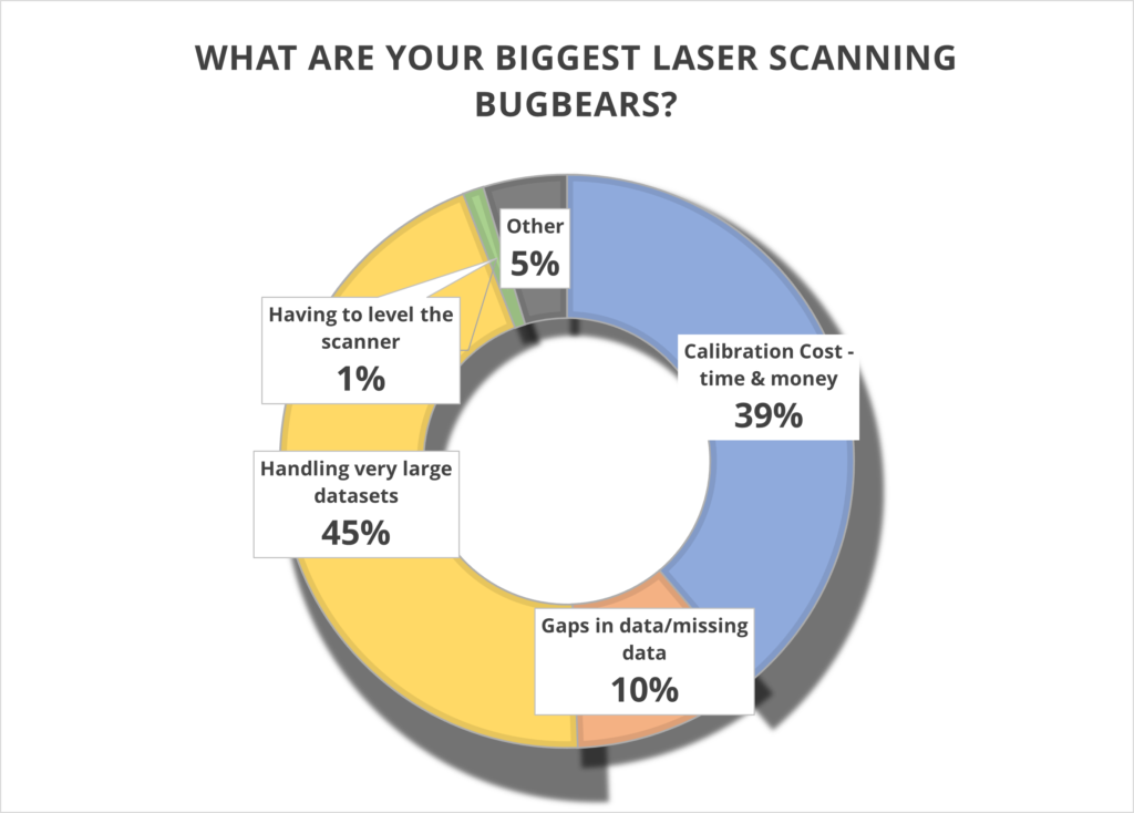
Has Trimble addressed these pain points? Let’s take a closer look.
1. Handling very large data sets (45%)
With surveyors often undertaking up to 100 scans a day, it remains vital that these large data sets can be handled quickly and efficiently. The X7 is perfectly equipped to do this because the scan is fully captured and registered in the field and then can be quickly reviewed and quality controlled in the office via Trimble Realworks. It’s you, the client, who is in the control of the workflow, not the manufacturer.
Additionally, the Trimble X7 captures four times less data (500,000 points per second compared to the 2 million or 1 million of other manufacturer scanners) which of course means less data to store and handle.
You can also avoid unnecessary expenses with storage devices by saving your data directly onto Trimble’s own developed and supported field tablet, the T10. Trimble is unique in that it develops its own scanner, software and tablet for a fully developed and supported Trimble solution.
We can also go directly to a CAD compatible format such as RCP from either the field with Trimble Perspective, or the office with Trimble Realworks, without additional licenses or import\export procedures. Less time in processing in the office, means the client can maximize production time heavily. Remember, having more data isn’t always better!
For more information, Trimble has a handy white paper on scanning and handling large data sets here.
Top KOREC tip – When handling large projects use ‘Labels’ to help organise the data in your project by adding a label like “kitchen or lounge” to each scan. You could also have different registration groups so you can split the scan data into Reg. Set 1 which could be Ground floor scans then Reg. Set 2 could be First floor scans.
2. Calibration cost – time and money (39%)
It’s your number two bugbear and we can completely appreciate why. Centara Ltd is just one of our customers who switched from its existing manufacturer’s laser scanner to a Trimble X7 because the business case made perfect sense. They calculated that the auto-calibration feature alone would save them in excess of £3k-4k a year because unlike their other scanner, the X7 would not need to be sent abroad for this process, nor would a replacement hire be needed for the duration which was usually around to 2-3 months. These savings enabled Centara to invest in additional kit that they were not expecting to purchase until the next financial year.
Other customers have cited the ability to ensure that data is always correct and validated with a calibration certificate as another plus. Evidence required? We’ve done a little video on how to calibrate your X7 in under 2 minutes.
Or why not take a Trimble ‘deep dive’ into auto calibration here
3. Gaps in data/missing data (39%)
Noticing that some of your data is missing only when you’re back at the office registering your scans clearly cuts deep with a large percentage of you. Not only is it frustrating, it’s also time consuming to revisit a site, particularly if entry is restricted.
Trimble has combatted this problem with one of the X7’s strongest features – infield registration. This feature enables users to stitch together different station positions automatically, in the field and directly on the tablet. It works indoors with walls, outdoors with vegetation and relies on a completely innovative alogrithim. You immediately see what you have and if there is a problem, or missing data, you can change settings or take more scans right away there and then in the field. Many Trimble customers have described this feature in just one word ‘Amazing’!
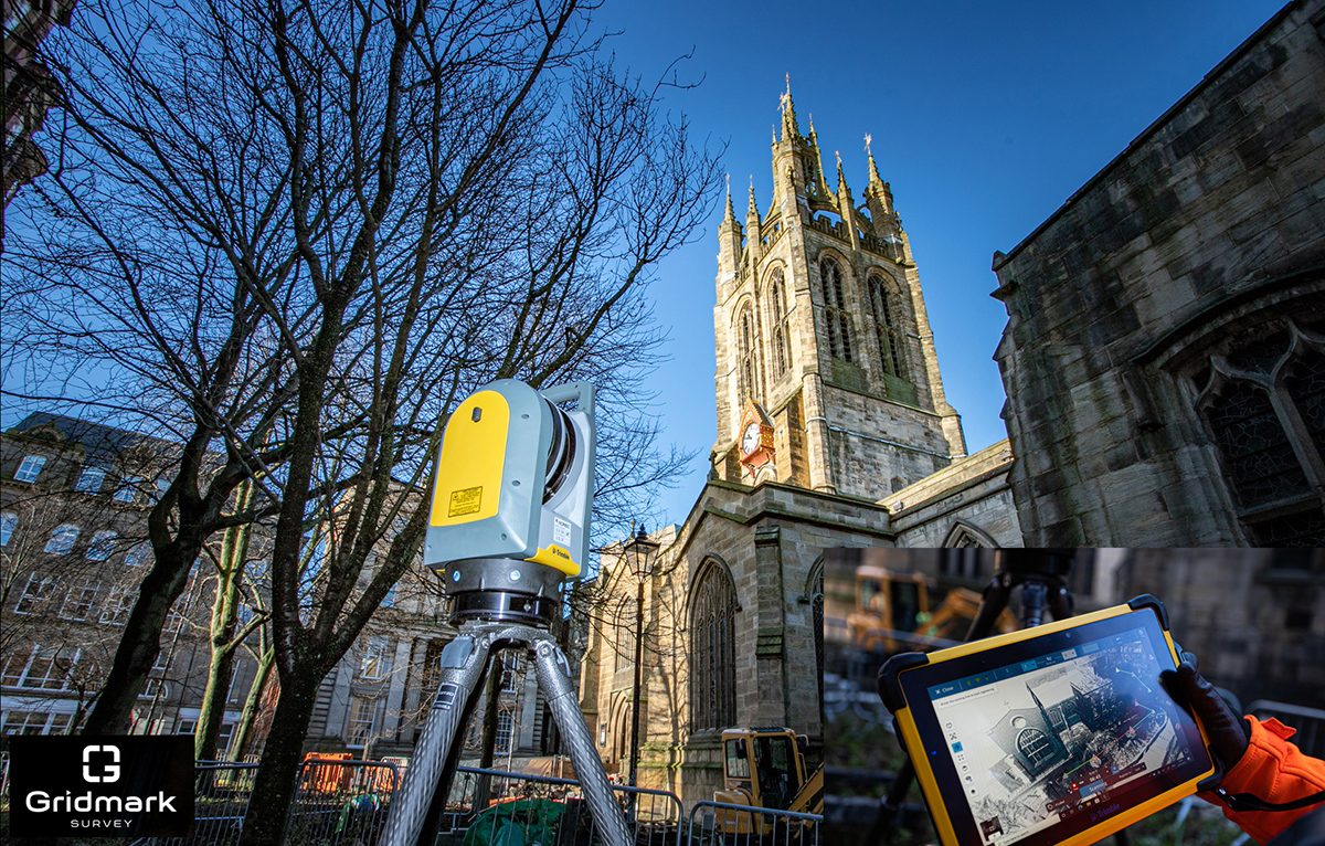
Gridmark Survey particularly appreciated the ability to automatically register each scan when they carried out a survey of the 900-year-old Newcastle Cathedral Church of St Nicholas. This allowed them to review everything in 3D before moving on. Overall, the Gridmark surveyors carried out 104 laser scans and collected 3.7 billion measurable points over a three day period.
4. Having to level the scanner (1%)
We’re amazed that only 1% of the vote went to this tiresome bugbear. However, for those under strict time pressures, it’s definitely a bonus X7 feature. In particular, Police Collision Investigators rate the ability to get the X7 up and running in minutes thanks to the quick release mechanism and automated survey grade self-levelling – they just put the scanner down and it’s ready to go. In each case, the instrument re-adjusts down to millimetre accuracy. There is no compromise with the Trimble X7 which has the IMU and Trimble X-Drive on all models, meaning data is always level and does not require post-processing.
5. Other (4%)
We appreciated all your comments including the addition of a couple more bugbears to our list:
a) Mirrors/Reflection/Refraction
Trimble is a leading hardware and software manufacturer and it is always pushing boundaries and leading development. Trimble appreciates that this remains a challenge and continues to work on a solution.
b) Portability
The good news is that the X7 comes in a handy backpack and weights just 5.8kg. It’s also got a handle!
Got a question? Want to find out more about the X7? Why not submit an inquiry with our friendly team?
Who needs low cost, on-demand, cm precision data collection?
“A cm accurate GNSS solution at the right price point.” Christopher Cooke of 3LM on Trimble Catalyst
We’ve just launched ‘A Grand Deal’ and it’s our offer of the summer! Mobile, on-demand data collection with centimetre-precision, our KOREC Capture data collection app and the KOREC Portal for review, analysis and reporting of data, all for under £1,000.
Key to this very grand offer and the exceptionally low-priced cm precision is Trimble Catalyst, our on-demand subscription based GNSS. Easy to set up and use, with a range of accuracy subscriptions available, the only hardware you need to purchase is the low-priced antenna.
But who can benefit from this offer? We took a look through our list of Catalyst users and the range is vast! Here are just some of the examples of KOREC customers who have selected Catalyst for their projects (full stories below):
V.T.O.L Media – establishing ground control points for aerial surveys
Operating out of Shropshire, V.T.O.L Media is a company that specialises in aerial photography, video and survey and in particular, construction monitoring. The company is owned by CAA Approved drone pilot, Neil Pepper, who has a mixed drone fleet and takes great pride in using only the latest in high-tech equipment.
The company has recently experienced an increase in demand for survey work with many clients requesting high accuracy aerial surveys. Aware that the use of ground control points would greatly improve the accuracy of any aerial surveys he undertook, and with many of the projects he was working on having little or no established GCP’s, he decided that the ability to establish his own would ensure total confidence in the accuracy of any aerial surveys he carried out.
Having researched various options for the precise positioning of chequer boards in wide open spaces or drains, road markings etc in urban areas, he found a perfect match for his requirements in Trimble Catalyst. Light, easy to use, compatible with his Android smartphone and by far the most cost-effective cm accurate system he could find, Neil says that he can place his GCP’s in under and hour and the cost of his Catalyst cm on-demand subscription is just £10!
3LM – a holistic approach to agriculture and the land
Yorkshire based 3LM is a member of the Savory Network, a global group that advocates, trains and supports land managers around the world to regenerate land through Holistic Management. 3LM specialises in the provision of educational and advisory services to agriculture and works with farmers who know that something needs to change, but are unsure what. Assisting this approach to change is the precise measurement and data capture of the four eco system processes fundamental to all life – water, minerals, solar energy and community dynamics.
3LM Company Director, Christopher Cooke has a strong background in both GNSS and water management and therefore turned to KOREC in his search for a cm accurate GNSS solution at the right price point. Finding the suggested Trimble Catalyst solution exceptionally easy to use and subscribe to, the company now has two systems comprising Trimble Catalyst, TDC600 logger and KOREC Capture field data capture software.
“The Trimble Catalyst system couldn’t be easier to use. It’s reliable, easy to subscribe to, and most importantly I know that our data is secure with zero chance of it being lost due to storage in both the cloud and on the TDC600. Having cm accuracy on demand allows us to accurately position any areas that we sample from and then navigate back to them at a later date for progress reporting. Additionally, the data management side of the system, developed by KOREC, really is world class.
“We have now achieved our aim of being paper free in the field and have particularly enjoyed how this technology has captured the imagination of the younger generation of farmers and land managers that we work with.”
TP Knotweed – rapid response identification and removal of knotweed
Aggressive, destructive, relentless, Japanese Knotweed is the most invasive plant in the UK and remains a major problem for the construction industry. One company specialising in its removal is Oxfordshire based TP Knotweed, a company that is prepared to invest in technology in order to increase efficiency, whether that be CRM, van trackers or new apps, or in this case Trimble Catalyst.
When TP Knotweed takes on a project, it’s vital that they have very accurate measurements as to the area of an infected site if they are to prepare an exact quote for their clients, along with a map of the project including the position of any boundaries, stockpiles trees etc.
For smaller sites, their solution was a Trimble Catalyst subscription for cm accuracy along with KOREC Capture software which could run on one of their existing Android smartphones or tablets.
TP Knotweed found the Catalyst system quick to set up and easy to use making it ideal for fast turnarounds on these sites. The company also reports that the systems are in use every day and that the quality and quantity of information they are collecting is proving vital for another of the company’s aims, to build a UK wide shareable database of knotweed contamination.
A14 Integrated Delivery Team – fast one-off positions and augmented reality in the field
The £1.5bn A14 Cambridge to Huntingdon improvement scheme was one of Highways England’s largest recent projects and the 34km site provided the contractors involved with a perfect testing ground on which to share new ideas and balance tried and tested technologies alongside new ways of working.
For Skanska’s Mark Lawton, Chief Engineering Surveyor, A14 Integrated Deliver Team, Trimble Catalyst provided two useful areas of investigation for potential use on future projects:
1. Contractors on the A14 scheme often required accurate positioning in ‘one off’ situations. For example, those carrying out borehole testing or soil sampling needed accurate positions either to map a new point or navigate back to a previously recorded one. However, it would not be cost-effective to send a fully trained engineer with survey grade GNSS to carry out these tasks. An obvious alternative was Trimble Catalyst, in this case using its on-demand subscription model with KOREC Capture data collection software running on the contractor’s smartphone. KOREC Capture could offer the contractors fully customisable lists, drop down boxes, mandatory fields etc which again would bring consistency of data, to the attribute information collected as well as cm positioning.
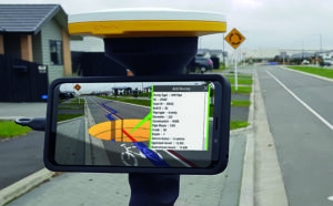
2. Mark also successfully trialled Trimble SiteVision, a system that fuses cutting-edge augmented reality technology with Trimble Catalyst centimetre-precision GPS. The end result is a system that allows you to take your models, drawings and data off the screen and onto your site. Key application areas included utility records, design information, future information and 3D models. In particular, Mark mentioned that on the A14, following the capture of hundreds of km of cable, they needed to know exactly where that cable was for a Permit to Dig. Having the information available visually through SiteVision was hugely helpful in determining where they could excavate.
Additionally, he says that SiteVision provides an easy to understand visual explanation to third parties, such as householders, as to why they are digging in a certain place.
What’s Next?
Take a look at the Trimble Catalyst product page
Watch the official Trimble Catalyst video on our YouTube channel
Make sure you follow KOREC Mapping for all the latest news, info and events
In the beautiful Staffordshire countryside lies 16.9km of preserved, standard gauge heritage railway better known as the Churnet Valley Railway. Noted for its nostalgic steam train rides and themed days out, it’s also now the destination for many KOREC customers keen to see the latest Trimble GEDO technology demonstrated on a track.
Following the restrictions imposed by lockdown on our usual demonstration area, we were delighted to have permission to base ourselves so centrally at the railway’s Kingsley and Froghall station where, over the course of the year, we have held many demonstrations for customers as well as training days for the KOREC rail team.
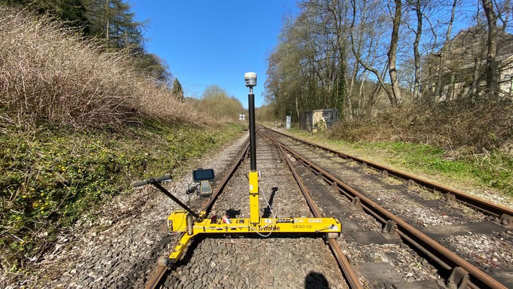
Of course, one good turn deserves another so we’re in the process of surveying the entire track to provide Churnet Valley Railway with a full survey, including 3D geometry, that will be particularly useful for any future maintenance work.
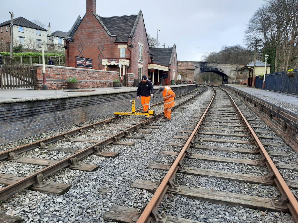
Whilst previously the Churnet Valley team undertook ad hoc surveys using traditional methods, KOREC’s Matt Barwell and Trimble’s Matt Moss decided that with the pick of the Trimble portfolio, by far the most time efficient method would be to use Trimble’s GEDO IMS + GNSS system which enables track survey and subsequent track design based on absolute coordinates with valid alignment elements. The R-series GNSS receiver was operated in conjunction with the GEDO IMU allowing them to shoot in control via the GEDO Profiler, which was used to measure distance and height offsets between the track and any reference point/object adjacent to the track.
The two Matts were extremely appreciative of the system’s time efficiencies having already surveyed around 8km of track (4km in each direction) in just 5 hours.
KOREC then processed this data and turned it into a DXF CAD ready drawing should Churnet Valley need it for any future maintenance.
We are delighted that our most recent visit to this scenic site resulted in a GEDO sale to Volker Rail for use on the Transpennine Route Upgrade East. More details soon!
KOREC’s Liverpool office has reopened for business and that includes in-person training.
We’re delighted to announce that as things return to normal, our KOREC Liverpool office is back up and running. One of the advantages that this brings is that we are again in a position to offer socially distanced in-person training. KOREC training packages can be bespoke, at a location of your choice or remote, but to get things started in Liverpool we’ve set up the following scheduled courses:
Intro to Topo Survey: June 8th – 10th
Intro to TBC: June 15th – 17th
The course calendar can be viewed here: https://www.korecgroup.com/training/
Taking these courses will be Richard Selby, KOREC’s Training and Technical Support Manager and Ian Hall, our Technical Support Office Team Leader, both hugely experienced in delivering high quality learning.
Of course we appreciate that things aren’t entirely back to normal so these courses will be run with a maximum number of 4 participants and in a large ventilated training room. In the rest of the office a one-way system is in place and social distancing maintained.
However, for those that prefer a more flexible approach, our successful KOREC GEOSCHOOL, on-line learning platform continues to offer a range of paid for and free of charge high quality training courses. These courses have all been designed to allow you to choose, where, when and at what pace you’d like to complete your training as well as providing lots of opportunity for questions and feedback from our qualified trainers.
Courses include our highly popular ‘Measured Building’ course a useful guide on measured building survey drawing from point cloud data using Trimble RealWorks and CAD software which will enable you to produce architect specified deliverables from point cloud data. If you have a scanner, or are planning to invest in one, or have an interest in Trimble RealWorks then this course is a must.
Expect around 6 hours of video tuition that combined with your assignments and assessments gives a course of around 2 days for you to dip into as you please. You can view the course details here or view the introductory video below.
“KOREC is firmly behind all the success I’ve achieved in the last 20 years at the Northern Ireland Forest Service. The right hardware, smart data capture software development and a great working relationship enabled us to revolutionise our data collection and management capabilities.”
At the end of 2020, former Information Systems Manager with the Northern Ireland Forest Service, Jim McEwan, joined the KOREC Mapping team as Customer Success Manager. In short, he liked the product so much, he joined the company!
Over the years, Jim has clocked up extensive experience in the forestry sector spending many of them working closely with KOREC and in particular, with our KOREC Mapping Lead, Paul Brodin. Jim tells us that an old dog can certainly bring some new tricks and here at KOREC we’re delighted to have him and his extensive experience as a high calibre resource for KOREC customers.
Experience counts
As Information Systems Manager with the Northern Ireland Forest Service (an Agency of the Department of Agriculture) Jim certainly has a wealth of experience to draw on, managing and implementing many projects from the development of his own real time data reporting systems using Trimble hardware and KOREC mapping software to introducing the first senseFly drones in the UK. Working in a sector as challenging as forestry, Jim has a clear idea of what really worked for him, as a customer, from the KOREC portfolio:
- Trimble data collectors – rugged and with a strong history of achieving a good signal even under tree canopies. Having the right hardware, that works first time, every time, in challenging forestry conditions was the initial step in building web-based reporting systems that put real time data, captured with KOREC software, directly into the hands of the forest manager.
- KOREC Capture software (that became Canopy) – the seamless integration of data from the field to the database and then to the GIS, allowed me to develop my own customised applications and for the first time, managers didn’t have to spend days pouring over data collected on paper forms.
- A good working relationship with KOREC that enabled me to talk directly to developers and turn my ideas into workable solutions that revolutionised the way we collected and managed our data.
…but it’s all about the end result
During his time at the Northern Ireland Forest Service, Jim developed a suite of bespoke forestry management systems, with the KOREC Capture portal at the centre. He looked at areas such as forest inventory, asset inspection, tree safety and a wide range of other forestry management issues and produced apps that gave users the data they needed with all calculations performed and maps added as required.
But it’s all about the end result and Jim was rightly pleased with what was achieved. “The results were amazing. In one example, pre-harvesting assessment plots, the data from forest plots was collected on paper and brought into the local office at the end of the week. Previously, the forester would spend two days a week inputting this data into excel to produce the stocking, volume and timber availability reports required. Now, the data is collected in the forest using Trimble’s Geo 7X ruggedised handheld and KOREC Canopy software. Once the data is sent back, the forester has the full pre-sales breakdown available immediately on a phone, tablet or laptop. The Forest Service has gone from 6 data loggers in 2009 to 120 today revolutionising surveying and data collection across the Agency.”
Jim’s success took him further afield within the Department. He worked with the Plant Health Inspection Branch and the Veterinary Service to produce real time reporting systems for Horticulture Marketing and Plant Health Inspections and developed the reporting system for a five-year project to monitor TB in badgers.
Talking Canopy
Now, Jim brings this experience to the latest KOREC Canopy software. “In terms of British Standard Tree Inspections and Tree Safety Management, we now have the solutions to allow you to collect, record and manage data quickly and easily. Combine that, with a full suite of reporting facilities and KOREC Canopy becomes the leading solution to the collection, management and reporting of tree data.”
Make no mistake, Jim understands the job from both sides of the fence!
If you’d like to learn more about KOREC Canopy from someone who knows the industry and the software inside out, please contact Jim at: jim.mcewan@korecgroup.com or call him on 07435 986865.

Jim McEwan at the Trimble Dimensions event in Las Vegas where he presented with KOREC’s Paul Brodin
Thanks to all the industry publications that continue to showcase KOREC supplied technology in our articles, columns and case studies. Here’s a round-up of where we’ve been in the last couple of months:

GeoConnexion UK (May/June)
The only way is up! Mark Poveda’s column is a must read for anyone who’s interested in the latest technology, opinion and developments in our industry. In his most recent piece, he takes a closer look at why the drone business is burgeoning and consequently, with so many choices on the market and new developments, why it’s never been a better time to invest.
Read his column here.
In the same, issue there’s also a great piece by Jodie Hartnell featuring the Trimble X7 which asks ‘Are laser scanners evolving into cobots?’
Civil Engineering Surveyor (April)
You may have noticed that we’ve just launched KOREC Mapping, in a move to consolidate and expand the KOREC offering of field to office data collection and handling solutions available across the UK and Ireland. It therefore seemed the perfect time for our KOREC Mapping Business Area Manager, Richard Gauchwin, to highlight a very important aspect of the digital data capture industry, namely ‘How technology can make a safer place for workers in the field.’
Read the full piece here.
Civil Engineering Surveyor (May)
For the May issue of CES, we revisited our popular case study format with a look at automated tunnel monitoring through a remote set up. Entitled ‘Whilst you were sleeping’ all the information for this piece was supplied by Mark Anderson, Director of Academy Geomatics. It’s proved a popular story with Trimble featuring it on their website and it will also appear in GIS Resources in June as part of their infrastructure/geomatics feature.
Read the full piece here.
Virtual reality, 3D Laser scanning, robotics, AI, reality data capture, data analytics….today’s careers in the geospatial industry offer numerous possibilities and are a perfect fit for the tech savvy, early adopters of Generation Z who have grown up immersed in technology.
Fuelled by technological developments, the collection and processing of spatial data is now a far cry from the days of just muddy boots and making maps and reflecting these advances is the Technological University Dublin which has recently adapted its BSC in Geospatial Surveying. Changes include a modular approach, updated content and opportunities to combine working with a relevant company whilst completing a degree.
Hands-on with technology
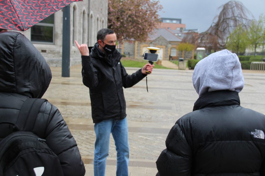
A vital part of any course is for students to be fully aware of developments within the industry. KOREC Ireland’s Mark Poveda, Niall Hand and Fran Mullally (geomatics graduates of the university), along with KOREC colleague Kevin Kinahan, were therefore delighted to have the opportunity to present some new ideas to the University’s 1st and 2nd year students. This was achieved through an on-line presentation and then a day of socially distanced hands-on experience with some of the world’s most advanced Trimble survey technology.
Bringing with them a selection of Trimble instruments including Trimble’s SiteVision Augmented Reality system, the X7 3D Laser Scanner and an R12i GNSS, Mark, Fran and Kevin also had KOREC sponsored hoodies for all the students involved, which was extremely fortunate given the rainy conditions!

Great weather for a new KOREC sponsored hoody!
Whilst the students enjoyed the hands-on session, KOREC’s Mark Poveda hopes that the on-line presentation provided a useful source of information on how far reaching and exciting the geospatial industry has become. Particularly well received was the ‘Spot the dog’ Trimble robot video which can be viewed here.
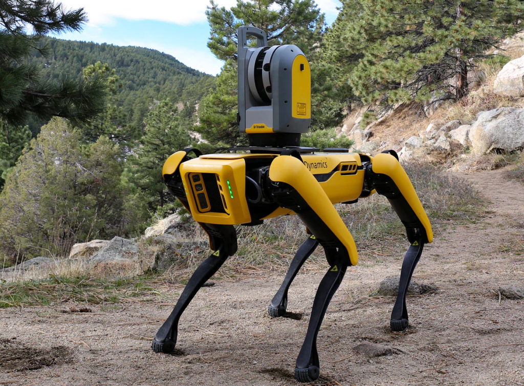
Spot the Dog
“The demonstration day was a great way to finish off my college experience in the BSc of Geographic Science. The Korec team talked us through the operating system of the latest Trimble survey equipment and offered us the opportunity to try out the instruments ourselves. The weather behaved in typical Irish fashion and rain showers were frequent. I was especially impressed with the quality of deliverables produced by the Trimble X7 Laser Scanner and accompanying touch screen under these conditions. The seamless workflow of this machine really highlighted the modern advances in technology enabling us, as surveyors of the future, to carry out surveys to the highest standard regardless of what the Irish climate throws at us. Advances such as these in technology makes me excited for my future career as a surveyor and I can only wait in eager anticipation of what else Trimble will release onto the market in the coming years. “
Rose Pearson, final year student, TU Dublin
Augmented reality with Trimble SiteVision
“…..the technology demonstrated was very sleek, it was extremely easy to use and makes quick work of any of the tasks given to them. The scanning technology particularly was great, especially being able to view scans right after taking them.”
“The day spent with members of KOREC was extremely insightful and enjoyable. The demonstrations they showed us offered an exciting look into the advancements of this industry and their equipment as well as the broadness of its opportunities.”
1st/2nd year students (TU Dublin)
Our thanks to Dr Audrey Martin, Senior Lecturer, Chair BSc Geographic Science (TU Dublin) and of course to the students who attended and were kind enough to provide some great feedback.
It was only a few weeks ago that we caught up with Sky Revolutions Company Director, Ben Gorham when Sky Revolutions became the first KOREC customer to invest in the newly launched senseFly eBee GEO. This time we’re back with Ben talking about a particularly successful week the company’s had with the Trimble X7.
Whilst picking up the new eBee from the KOREC Huntingdon office, members of the Sky Revolutions team took the time to take a closer look at a Trimble X7 3D Laser Scanner that was on site that day and immediately saw how it could contribute across the business and in particular, to an upcoming measured building survey project.
With over 20 years’ experience in construction surveying, Sky Revolutions undertakes a wide range of work and until recently carried out its measured building surveys using the traditional method of a Trimble S7 Robotic Total Station. However, already familiar with 3D laser scanning technology, they were keen to see what the X7 could deliver on the planned job of 25 measured building surveys on structures ranging in size from as small as a shed sized sports pavilion to as large as an office block with everything in between.
When we caught up with Ben, the Sky Revolutions team had successfully completed eighteen of the scans in just four days and expected to be finished in five. Ben explained, “Our aim is to deliver projects promptly and to supply our clients with data of the highest quality. The X7 has been exemplary in helping us achieve those aims. The scan speed alone has really assisted on this project as did the smart auto-calibration. We’ve had laser scanners before but the X7 is a step ahead. The argument for not buying one doesn’t really exist!”
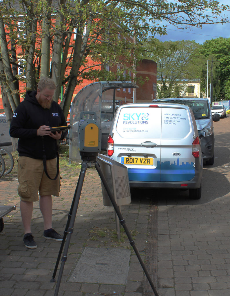
Sky Revolutions surveyor Dave Gaffney puts the Trimble X7 through its paces
Peterborough based KOREC customer, Sky Revolutions, is a company that certainly knows its way around the aerial mapping sector and as one of the very earliest UK surveying businesses to realise the benefits of drone surveying, it also has an extensive knowledge of the technology involved.
That’s why we are delighted to announce that it has become the first company in the UK to take delivery of senseFly’s newly released fixed wing drone, the eBee GEO.
Designed to deliver senseFly’s superior build quality and extensive functionality at a fraction of the price of similar drones, the eBee GEO is all about user ROI and is especially suitable for the many varied projects that Sky Revolutions undertake.
For company Director, Ben Gorham, the eBee GEO is a perfect choice for Sky Revolutions which has seen an upsurge in demand for aerial survey work following the restrictions imposed by COVID.
Ben rates the eBee GEO for four particular reasons:
- The RTK option allows the Sky Revolutions team to achieve the 2.5cm accuracy demanded by many of their projects
- With a battery life of 45 minutes, the eBee GEO is a producitive choice for the increasing number of larger jobs the company is working on
- The S.O.D.A. camera provides impressive accuracy at 400ft
- Some of Sky Revolutions’ jobs, such as a recent coastal survey in Suffolk, involve several miles of walking. The eBee GEO has a take-off weight of just 1.3kg and is easy to transport in a backback.
Ben concludes, “There’s no doubt that the eBee GEO makes good sense for us financially and with its impressive accuracy it is the perfect addition to our fixed wing offering. KOREC’s been great at meeting our requirements and understands that we are a company valued by our customers for our specialist surveying skills and consequently have high expectations of every investment we make.”
Sky Revolutions has just successfully completed a first mission with the eBee GEO carrying out a coastal survey on behalf of Suffolk County Council.
Sky Revolutions pick up their new eBee GEO from KOREC’s Huntingdon base. From left to right, James Tindall (KOREC Geospatial Technical Support), Lloyd Wilkinson (KOREC Geospatial Sales Consultant), Ben Gorham (Director, Sky Revolutions), Madison Gorham (Apprentice, Sky Revolutions), Anna Carter (Office Manager, Sky Revolutions)
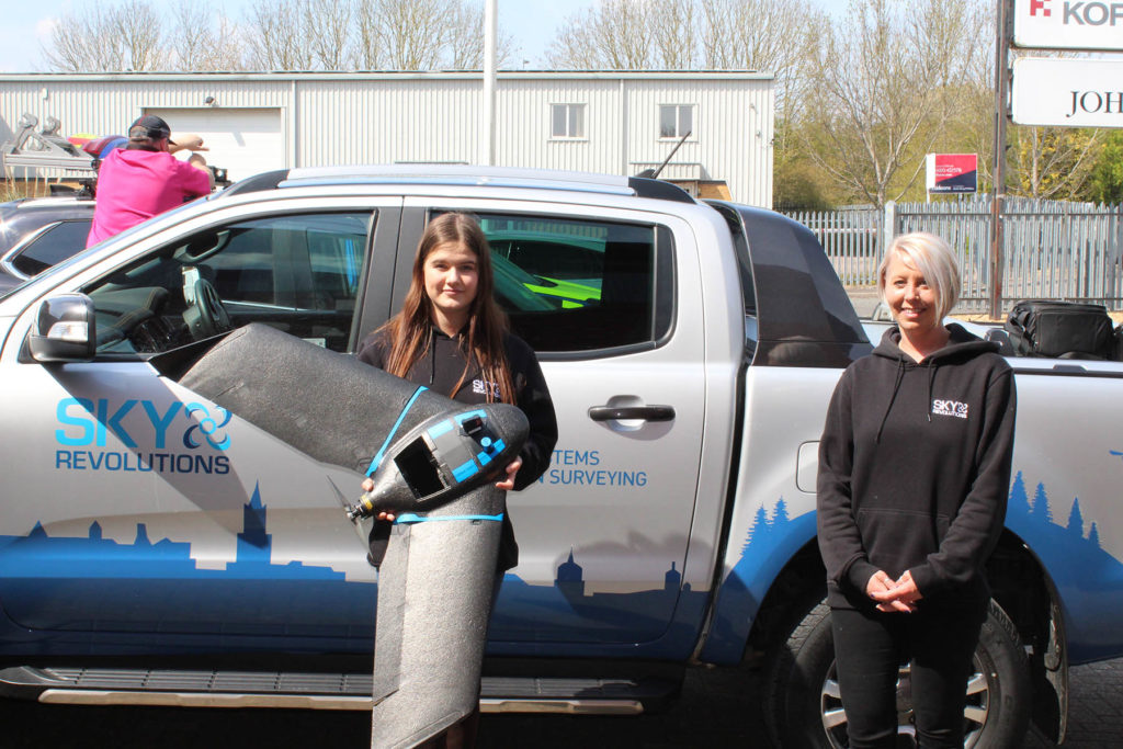
Madison Gorham (Apprentice, Sky Revolutions) and Anna Carter (Office Manager, Sky Revolutions)
Definitely not when it comes to examining why the Trimble X7 3D Laser Scanner lends itself to the pressures of crime and collision scene investigation!
We round up the top ten reasons why the X7 delivers on key requirements.
Over the years, KOREC has enjoyed a long and informative relationship with the UK’s police forces supplying a range of survey instruments from integrated GNSS and Total Station Systems to more recently, 3D Laser Scanning technology including the groundbreaking Trimble SX10 Laser Scanning Total Station.
Crime scene and collision evidence gathering is a discipline that brings its own set of challenges. The pressure to work quickly and capture every detail of a scene, often with no chance to revisit the site later, means that the emergency services need to have 100% confidence in the reliability of their data. They need to be able to gather that information quickly and it needs to be accurate, all encompassing and sufficiently robust to stand up in a court of law. Consequently, we’ve seen a shift towards 3D Laser Scanning as the best methodology for capturing a scene as quickly and completely as possible. Additionally, this can often be done from the side of a site reducing the chances of contaminating evidence.
The latest Trimble X7 3D Laser Scanner lends itself to the unique set of challenges faced by the police in a number of ways:
- Ease of use – the learning curve for the X7 is the shortest of any scanner we’ve ever seen with our training department estimating that even a non-surveyor can be efficient in data collection within hours. This gives it a far wider range of use. Thanks to its intuitive Perspective software running on a tablet, crime and collision scene investigators can reliably collect scan data even if they have not used the instrument for several weeks.
- Fit in with your existing workflow – export formats supported include Trimble and non-Trimble software through the instrument’s new Trimble Perspective software. For example, the open .E57 format for easy importing of data straight into Leica’s Cyclone software.
- Verification of information on site – the X7’s automatic on-site registration means that officers can check that all the information they need has been collected. Often there is no chance to revisit a scene, so this feature is vital for ensuring a full and detailed survey has been completed before leaving the site.
- Survey completed and sent from the site – with registration carried out on site, the finished scan data can be sent from the field for immediate analysis. This ensures a smooth flow of information in an environment where shift work and office processing time can delay the final deliverable by days.
- Fast set up and use – the X7 can be up and running in minutes thanks to the quick release mechanism and automated survey grade self-levelling – just put the scanner down and it’s ready to go.
- Night-time benefits with easy moving and set up around the site – an IMU has been included in the X7 which calculates the new station orientation and will import new data with this orientation already applied. The registration process which follows is then much faster due to the scan already having the correct orientation- just pick it up, hold it as you wish, walk where you want and put it down. This also makes it great for night-time working because unlike other manufacturer’s scanners it is not subject to the dark/low-light condition caveats that optically based solutions are.
- ROI – auto calibration brings reliability, cost-savings and no downtime – not only is the X7 priced competitively, but users are calculating that the auto-calibration feature alone can save in excess of £3k – £4k a year because unlike other manufacturer’s scanners, the X7 does not need to be sent abroad for this process. Instead it’s done automatically, every time it’s used, with the option of a printable certificate.
- The calibration of some instruments can take up to 2-3 months requiring the hire of a replacement instrument. The X7 eliminates the need for this.
- Rain never stops play – Trimble instruments have a proven record in the rain and with its IP55 rating, the X7 is no exception.
- Highly portable – the X7 weighs just 5.8kg and can be carried easily in a backpack.
- Excellent data quality – fast data collection plus the option of a high sensitivity mode for scanning dark vehicles etc.
- Images and annotations – Trimble Perspective software on a tablet drives the X7 and allows users to annotate, add images, tags, notes etc.
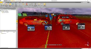
Scan data from the Trimble X7
For further information on the Trimble X7:
Call UK Sales: 0345 603 1214
Call Ireland Sales: 01 456 4702
For anything else, view our contact page.