Quick Guide: Choosing the right Trimble GNSS
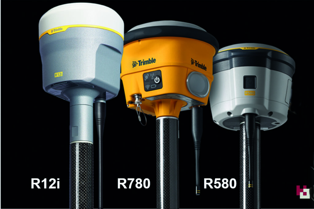
How to choose the right Trimble GNSS for your survey applications – a quick guide to our three best-selling receivers, the R12i, R780 and R580


How to choose the right Trimble GNSS for your survey applications – a quick guide to our three best-selling receivers, the R12i, R780 and R580
How to choose the right Trimble GNSS for your survey applications – a quick guide to our three best-selling receivers, the R12i, R780 and R580
Choosing the right Trimble GNSS receiver depends on several factors, including your specific application, accuracy requirements, environmental conditions, and budget. Here are some key considerations to help you make an informed decision:
In a nutshell:
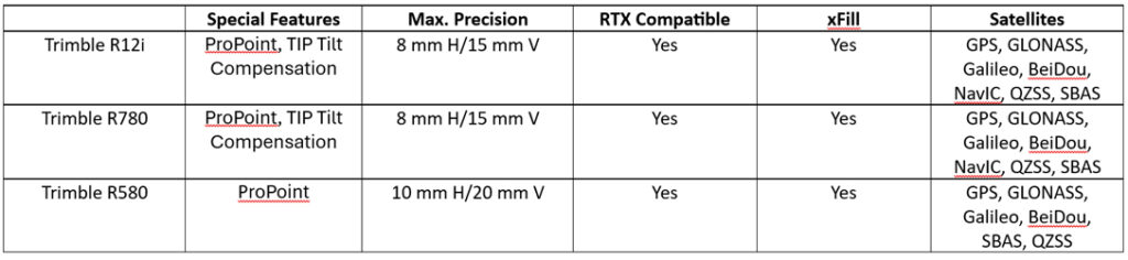
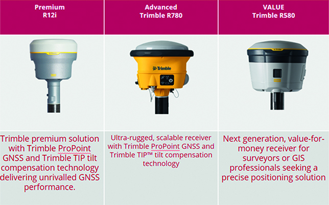
The Trimble R12i is a premium survey GNSS offering dual Maxwell 7 Gen chip, fully loaded with all constellations, and can be used as a base and rover. Features include TiP technology (Trimble Inertial Positioning), ProPoint and xFill limited. It’s the best-in-class GNSS receiver with tilt technology and all of these features are offered as part of the standard package.
The Trimble R780 is a scalable survey GNSS offering ProPoint, a single Maxwell 7 Gen chip and is upgradeable to enable Tilt and full constellations. It can be used in base and rover modeAdditionally it has an ultra-strong housing and an increased IP spec. . This is the perfect receiver to grow with your business.
The Trimble R580 will provide the best return on investment and an affordable way to buy into the Trimble brand. It’s enabled with all constellations, ProPoint technology, and xFill Limited. However, it does not include TiP technology and is not upgradable.
FAQ’s
Which of these Trimble GNSS receiver models offer tilt compensation technology?
The Trimble R12i and Trimble R780 both offer Trimble Inertial Platform (TIP) IMU-based tilt compensation technology.
Which Trimble GNSS receiver models offer Trimble ProPoint GNSS technology?
The Trimble R12i, Trimble R780, and Trimble R580 GNSS receivers all come with Trimble ProPoint technology for increased performance in challenging GNSS environments, including close proximity to trees and in urban environments.
Which Trimble GNSS receiver models support Trimble RTX corrections?
All three models support Trimble RTX corrections, both via L-band (satellite) broadcast and over the internet.
RTX is a streaming service for corrections, managed by Trimble, which provides a correction service using a geostationary satellite – it does not require an internet connection.
On the RTX streaming service there are two products that our GNSS portfolio can use, xFill and xFill unlimited.
What is Trimble xFill limited
All three receivers offer Trimble xFill Limited as standard. This feature enables cm-levels corrections whenever the internet connection goes down for up to 5-10 minutes allowing surveyors to carry on working.
What is Trimble xFill unlimited
This feature enables the GNSS to carry on working with satellite corrections, without internet, for an unlimited amount of time. However, the user needs to be connected first to a VRS network for this to work. Ask us about our current special offer on xFill unlimited.
What is Trimble VRS Now Trimble VRS Now is a network of Continuously Operating Reference Stations (CORS), which provides users with cm-level corrections for their GNSS instruments, via the Internet. This enables users to work to cm-level anywhere there is a VRS network and a mobile internet signal. Trimble has additional permanent reference stations across the UK to strengthen the overall RTK solution, augmenting the network – increased accuracy and availability.