How the best (the Trimble R12i) just got better (the new Trimble R980). Introducing the new Trimble R980 GNSS

When you buy into the Trimble brand and KOREC support, every GNSS receiver you choose has something in common – all of them are based on Trimble’s 40-year heritage dedicated to reliability and innovation and they are all backed up by KOREC’s renowned technical support, training and T.R.U.S.T ethos. You’re buying into a premium brand and that brings a host of proven benefits including long term value, extensive R&D and high-level customer support.
….and the Trimble flagship GNSS is of course the R12i, at least that was until today! We’re delighted to announce that the best just got even better with the launch of the new R980 GNSS receiver.
So, what’s new apart from a nifty new name that ties it in with the existing R580 and R780 receivers?
Well, here’s what you get with the Trimble R980 standard package:
- NEW: Now has a 4G internal modem as opposed to the R12i’s 3.5G. For the UK market that means users can make the most of the additional bandwidth and gain more speed. And of course, in the GNSS world, it’s usual that the faster the internet is, the better the accuracies you achieve.
- NEW: A dual band UHF 450/900Mhz Radio has been added, (the R12i had just a 450Mhz radio) making it suitable for use across the world with a single board.
- NEW: An expanded internal memory up from 6GB for the R12i to 9GB for the R580. Perfect for logging raw data for post processing within TBC for a useful workflow for establishing ground control points and networks. 9GB will give you up to up 15 years of continuous logging of observations within the R980, capturing GPS and GLONASS data every 15 seconds. That’s a lot!
- Trimble TIP Tilt technology – it’s the most accurate tilt technology in the world today offering calibration-free Inertial Measurement Unit based tilt compensation with immunity to magnetic interference.
- Trimble ProPoint – for increased performance in challenging GNSS environments, including close proximity to trees and in urban canyons.
- Trimble xFill as standard – this feature enables cm-levels corrections whenever the internet connection goes down, for up to 5-10 minutes, allowing surveyors to carry on working.
- 12 months of CenterPoint RTX positioning insurance – this feature enables the GNSS to carry on working with satellite corrections, without internet, for an unlimited amount of time.
A firm supporter of Trimble GNSS technology is James Richards of Benchmark Surveys. We asked him why he rated it so highly, his answer: “It always works”, which has to be the best reason of all!
Read his thoughts here and here.
….and don’t forget – Trimble users have a single source of supply for the complete GNSS workflow – VRS Network, Mobile SIM cards, GNSS hardware, controllers, field software and augmentation services like Trimble CenterPoint RTX – just call KOREC.
Fairyhouse Racecourse leads the way in consistent, centimetre accurate, sectional timing data with IHRB approved low-cost, ground-breaking Trimble GPS system.
Download a PDF of the story here
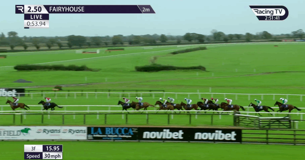
Typical on-screen information generated by Course Track from data captured by the Trimble Catalyst system
There have been longstanding concerns about the accuracy of sectional times in Irish race meetings particularly following some high-profile queries on race distances. However, Irish racing is addressing the problem and leading the way is Fairyhouse Racecourse, one of the country’s premier horse racing venues and home of the Irish Grand National.
In the world of horse racing, where comparisons related to pace, ground conditions and distance are paramount for form-study, the accuracy of furlong distance measurement is of utmost importance. Equally crucial is ensuring that the furlong measurements align with the timings displayed on television broadcasts.
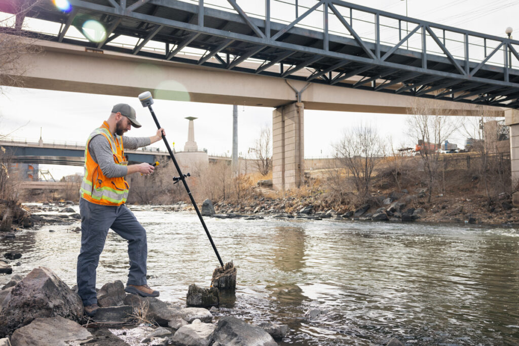
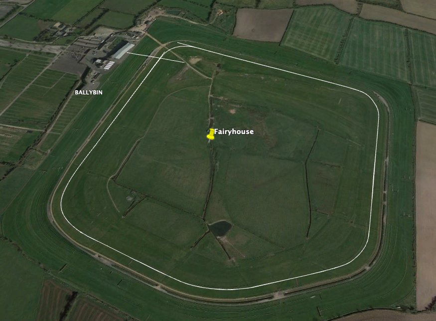
Fairyhouse has proactively addressed this issue with the adoption of a centimetre accurate GPS solution that they have customised for the production of highly accurate maps of every course circuit for each of its twenty-one annual meetings. Under the guidance of Fairyhouse General Manager, Peter Roe and Track Foreman, Richard Stapleton, the course has rigorously tested, implemented, and secured approval from both the IHRB and CourseTrack (tasked with introducing sectional timing by 01/24) for its new Trimble Catalyst GPS system. The system was purchased from Trimble distributor and geospatial specialists, KOREC.
Peter Roe is especially aware of the racing industry’s increasing demand for precise data, numbers, and information for assessing a horse’s form correctly. “Unfortunately, traditional survey methods that rely on measuring wheels have proved inadequate in delivering accurate furlong measurements to the extent that we’ve had races where all seven runners appeared to break the track record. Subsequent checks revealed that the race was run over a shorter distance than initially advertised. Extensive testing by Fairyhouse of wheel measurements compared to our new survey level Trimble GPS have revealed discrepancies as high as 32m over an 8-furlong race.”
Easy to use, low cost and consistent centimetre accuracy
As the first racecourse to independently look at the technology that could assist with accurate furlong measurement for sectional timing data, both Peter and Richard were keen to implement a system that not only worked for them, but would be easily usable by other interested racecourses. Their three demands of any new system were that it was easy to use, especially for courses where staff were less technical; it had to produce reliable centimetre positions and it had to be affordable:
Achieving cm accuracy: Whilst the survey industry offers many centimetre accurate GPS systems, these tend to be designed for professional surveyors and therefore come with an extensive range of features designed for survey workflows and can cost in excess of €30,000. However, through farming contacts, Peter was aware of an alternative system, called Trimble Catalyst, that worked on an entirely different subscription-based model.
The Trimble Catalyst business model has been developed for people exactly like Peter and Richard who wish to pay only when they use the system because they require centimetre positions to supplement their primary area of work rather than all day, everyday.
The Trimble Catalyst hardware comprises a simple, low cost, lightweight Trimble DA2 GNSS receiver which offers survey-quality (cm) positioning, even in challenging GPS environments including near and among trees and buildings. The receiver is easily connected to an Android or iOS device. Fairyhouse selected a handheld Nautiz X6 ultra rugged Android phablet as being the most suitable handheld to work with their Catalyst system. The field software running on board the Nautiz X6 was KOREC’s in-house suite of customisable software, K-MATIC, including K-CAPTURE field software. The K-MATIC suite also includes the highly secure, KLEARVIEW360 cloud-based Portal for analysing, viewing and sharing the collected information.
Low cost: The cost of the Trimble Catalyst DA2 receiver part of the system has been kept at less than €500 per unit and comes with an ‘on demand’ subscription pricing model so users can select the accuracy they need, 1cm, 10cm, 30cm or 60cm. Richard opted for a 1cm accuracy subscription optioned in hourly bundles which he knew from testing, would give him sufficient time to measure the course circuit at a brisk pace to keep it within the hour.
“Ease of use has been a key concern for us in working with KOREC to create a system that’s going to be useful for other courses, some of whom would only be using it four times a year. KOREC’s customer service and technical support have been brilliant – we didn’t just buy a tool but also a team!”
Richard Stapleton, Track Foreman, Fairyhouse
Ease of use: Whilst Richard acknowledges that he is obsessed with accuracy and good with numbers he is also aware that for any system to be widely taken up it has to be easy to use and understandable with a single days training. He therefore worked closely with the KOREC development team to develop a stripped back data entry form that was based exactly on the information that the UK media company required. This included the auto recording of the race line as it was walked by Richard and the ability to stop and mark each furlong and then continue the measurement of the race line. “Ease of use has been a key concern for us in working with KOREC to create a system that’s going to be useful for other courses, some of whom would only be using it four times a year. Whilst we have customised the software, I think it can still be simplified further. The attraction of a wheel is that it requires no training whatsoever and whilst we’re never going to achieve that, our Catalyst system has been simplified with customised features specifically for furlong measurement.”
“The aim was always for Fairyhouse to be 100% accurate. Our extensive testing of wheel measurements compared to our new survey level Trimble GPS have revealed discrepancies as high as 32m over an 8-furlong race.”
Peter Roe, General Manager, Fairyhouse
Using the system
Although the Trimble Catalyst system is very light and highly portable over long distances, Richard has opted to use it in a backpack to keep his hands free for positioning furlong markers etc. In preparation for races, the rail has to be positioned as early as possible and then Richard will walk the track, measuring one metre out from the rail. The reliability of the system is key to its success particularly when races are run over three days, such as the Easter Festival, which can see him marking out six race lines. This has to be completed in plenty of time to supply the information to CourseTrack in England.
Accurate timing data is now being generated
For each circuit, Richard establishes vital reference points on the track which allow him to accurately position the start and the finish lines. Once the data is collected, it is downloaded onto the Portal for a visual check of the map and to ensure that all furlong markers and bends are correct. It is then emailed to all those who require the course information. On race days the information is used by CourseTrack to link up with trackers that each horse carried in its saddle cloth to provide accurate timing data.
“The CourseTrack system relies on accurate measurement of race distances and track layout in order to deliver sectional timing for each individual race. The team at KOREC has worked closely with Fairyhouse and other tracks in Ireland to create a bespoke product for those racecourses which the system suits, and we have high levels of confidence that the KOREC data can support accurate live and post-race data.”
Chris Murtagh, Director of Operations, CourseTrack
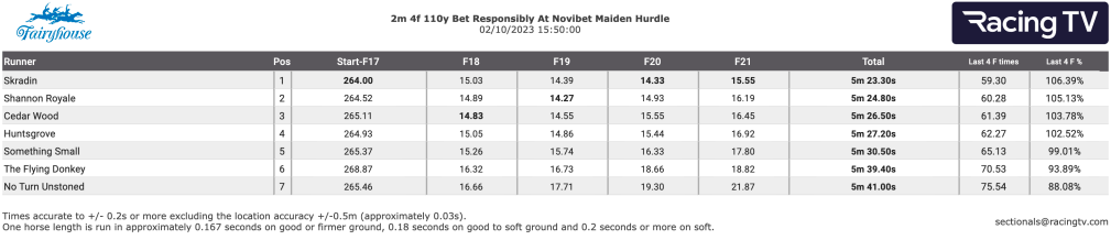
A visual check is always made of captured information
Future plans
While Peter emphasises the solution’s standout benefit of delivering reliable centimetre positions, he also acknowledges the vital role of KOREC’s support in the system’s successful adoption.
“Our aim was always for Fairyhouse to be 100% accurate and I think that we’ve achieved that. KOREC has been extremely loyal to Fairyhouse on this project. We invited them to come on a journey with us that may or may not work out and they’ve supported us throughout and now we’re both being rewarded. The Catalyst system is a game changer and we’ve got plans to customise it further by adding in fences and distances to create some really nice visuals for social media. It could be an amazing tool for the industry.”
Richard concludes, “KOREC’s customer service and technical support have been brilliant and I feel that we didn’t just buy a tool but also a team!”
Several other tracks have recognised the system’s value and the dedicated efforts of Peter and Richard in securing its approval, leading to further adoption across Irish courses.
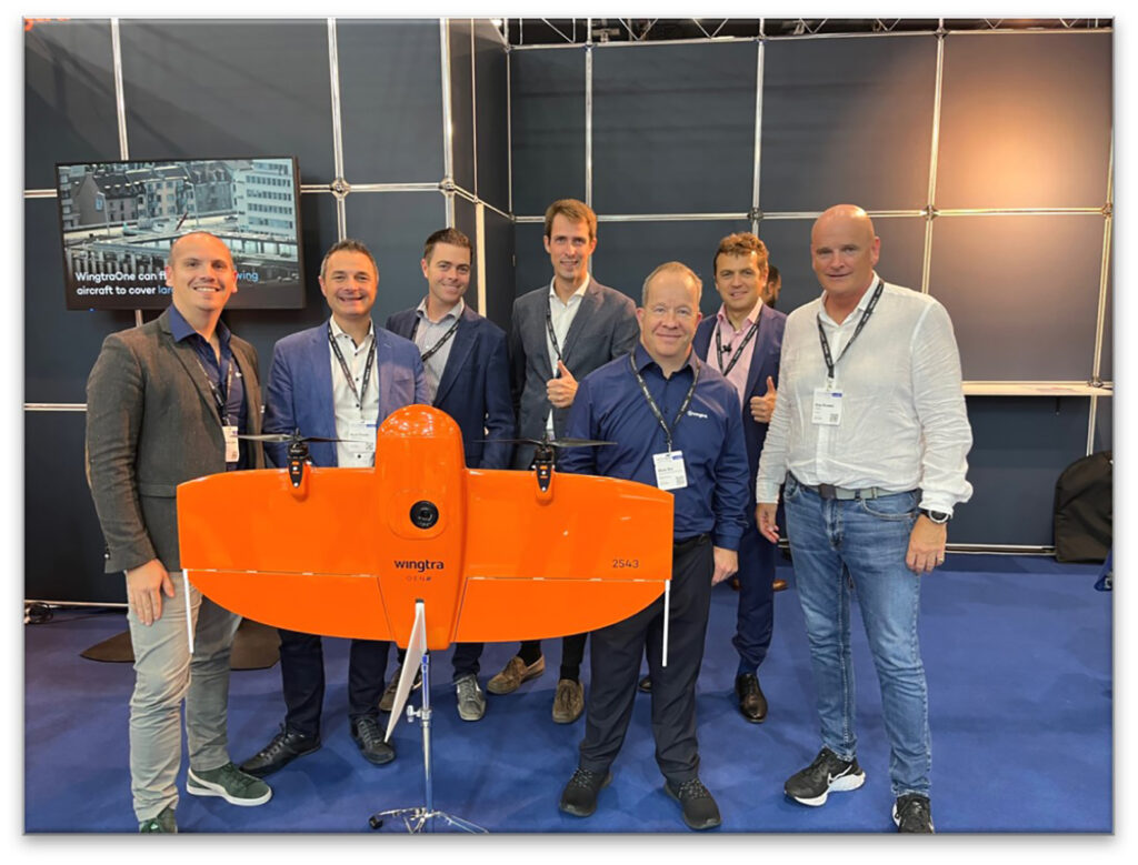
From left to right Matthieu Lefebvre, (Head Of Sales EMEA), Mark Poveda (Group Commercial Director, KOREC), Shane Murtagh, (Sales Director, Ireland, KOREC, Maximilian Boosfeld, (Wingtra Founder), Adam Box, (Regional Sales Manager UK & Benelux, Wingtra), Aleksander Kostadinov, (Global Sales Director), Alan Browne, (Group Chief Executive, KOREC)
KOREC Group is delighted to announce that it has signed an agreement to become the latest distributor to join the Swiss company’s global network of suppliers.
The agreement will see KOREC strengthening its existing fixed wing portfolio to include the WingtraOne, a premium survey drone that offers vertical take-off, PPK geo-referencing and a high-resolution payload for the consistent delivery of the high-quality data required for mapping and survey specific applications.
KOREC will build on this distributor role to establish a network of Wingtra dealers in the UK.
Mark Reid, UK Sales Director, KOREC said: “Wingtra is a world leading fixed wing mapping drone producer and its commitment to the advancement of the WingtraOne platform is truly impressive. This Wingtra ethos of continual development perfectly aligns with KOREC’s dynamic. The WingtraOne drone has already established itself as a reliable and trusted technology, making it an ideal match for our existing Trimble and K-MATIC solutions. With upcoming developments on the horizon, we look forward to working with Wingtra for a successful future.”
Adam Box, Regional Sales Manager UK, Wingtra said: “There is such a strong synergy between the technical solutions KOREC provides and the Wingtra solution that we couldn’t be happier with this new partnership and the opportunities that it will generate. The future looks bright and exciting and I cannot wait to help them paint the sky orange.”
KOREC will offer a full WingtraOne distributor service including sales, training and support throughout the UK and Ireland.
ENDS
Download a PDF of the press release here
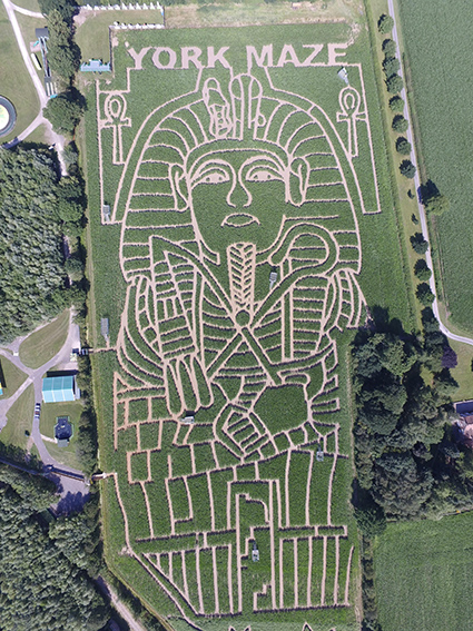
Visitors to York Maze will find this year’s amazing maize maze, even more challenging thanks to the accuracy of a KOREC supplied Trimble TDC650 handheld GNSS.
York Maze, Maze Master Tom Pearcy, has created another fantastic maze using over 1 million maize plants in an area larger than 8 Wembley football pitches, making it the largest maze in Britain and one of the biggest in the world!
Over the years, Tom has tackled many themes from Star Wars to Lego and Roald Dahl to Mr Men, all using a KOREC supplied Trimble Geo Explorer with its 0.5m accuracy. However, this year, Tom has upped the ante and opted for a handheld Trimble TDC650 (scalable positioning from metre to centimetres). The incredible result is a complex maize tribute to Tutankhamun to celebrate the 100th anniversary of his tomb being discovered. Tom has been delighted with the results:
“The TDC has been great for mapping out the maze, it holds its accuracy all day long, and it didn’t lose its connection for the whole time we used it, something the previous models could be prone to. The accuracy allows us to create ever more complex mazes, that look truly amazing from the sky !! “
Tom Pearcy, Maze Master, York Maze
A couple of years ago, Tom revealed exactly how the maize magic happens.
“We’ve come a long way since our first creation in 2002. Back then our mazes were based on just lines and circles drawn onto graph paper and in the field, we used sticks and strings to set out the design, a time-consuming exercise which could take two weeks or more.
Today the process is much more straightforward. Our theme is designed in a basic drawing package and then uploaded onto our Trimble handheld GNSS. We then go out into the maize field and effectively create the biggest dot to dot in the world!
Using the map on the handheld, I plot out the design amongst the 6” high maize plants, marking the points as I go, whilst a cultivator follows on behind.”
This year saw Tom cut over 5km of pathways into the 15 acre field to create the ‘iconic’ image of King Tut.
York’s maize maze is open from Sat 15 July – Mon 4 Sept 2023 and you can book tickets here.
If you’d like to learn more about the Trimble TDC650 call our KOREC Mapping Team on UK: +44 (0) 345 603 1214 or Ireland +353 (0) 1456 4702
We’ve always believed that the geospatial industry offers up some fabulous stories, great personalities and interesting points of view and that now’s as good a time as any to celebrate this with some quick fire interviews.
In the first of our ‘Latitude and Attitude’ series, we posed 10 questions to Mike Roller, Civil Engineering Surveyor, Galliford Try. Why did we pick Mike for our first post? Well, the KOREC team has been lucky enough to socialise with Mike at work related functions over the years, including a recent trip to Trimble Dimensions in Las Vegas, so we knew he’d be a safe bet for some great stories…. and that with over 30 years in the indsutry working for some of the biggest names including Balfour Beatty, Skanska and even Trimble, there was a rich vein to be mined. Mike didn’t disappoint!
Why did you choose a career in surveying?
I was advised by my then Maths teacher to take a one or two-day course run by Birkbeck College. I believe it was called Vocational Guidance. They gave me an IQ test and alternatives from which to choose that were basically indoor or outdoor, using your brain or your hands, arts or sciences…etc. They concluded I could achieve a maths degree and my aptitudes lay in something like Clerk of Works or Quantity Surveying. I tried for a job in Quantity Surveying and thought I’d try for one in Land Surveying as well thinking they must be similar. I got the job in Land Surveying.
If you weren’t a surveyor what would you be….
I tried to join the RAF as a Pilot Officer on a twelve-year commission. I passed the medical and got good marks in the flying aptitude tests during the first two days of a four-day course at Biggin Hill. Unfortunately, I didn’t get to the next two days as, during the interview at the end of the second day, I was deemed “not officer material”. It was only several years later while I was applying for Canadian citizenship (my dad was Canadian) that I discovered that my dad’s parents were Russian, which I felt may have actually been the reason, it was the 1960s, the Cold War etc…!
What was your most memorable survey moment?
I spent a year doing all the survey and setting-out for a five-kilometre conveyor belt for British Gypsum between their mine in Brightling and their processing plant at Mountfield, East Sussex. It was the first of its kind to follow the contours of the route rather than being a series of straight belts. The belt was pulled from the Mountfield end along a route which consisted of horizontal and vertical curves so any inaccuracy in the positioning could result in the belt being pulled off its rollers. When the M & E team came to commission the belt, they had allowed two months to tweak any problems. They started it up and it ran perfectly. They then loaded it with gypsum, and it continued to run perfectly so after two days they were on their way home!
What was your most dangerous survey moment?
Being shot while working in Iraq during the war with Iran in 1981. I still have the bullet lodged so close to my heart that the surgeon(s) thought it safer to leave it where it was than to try to remove it.
What was the best project you’ve worked on?
Lingfield all-weather racecourse. I carried out all the survey and setting-out for this contract during which time I was given free badges to bring my family to watch the horse racing free of charge. They were very enjoyable days out and we had three of them during the year I was working there.
What are your top three surveying tips?
Check, check, check.
Tell us about your favourite survey story
I worked for a year for the Eastern Road Construction Unit checking the setting-out of the alignment of the M11 as it was later to be known. I was checking the northern most section down to the A10, then three colleagues were doing the same for three more sections down as far as the North Circular Road. We used to meet up in a pub in Great Chesterford after work one or two evenings a week and on one particular evening, one of the other locals who was often in the pub after a train journey from London (let’s call him Simon, early thirties, not a surveyor) received a phone call on the pub’s land line…
Landlord: “Simon, it’s for you.”
Simon: “Hello? oh hello darling,” (pub goes a bit quiet, listening) “well, yes, about half an hour” (pub goes very quiet, listening intently by now), “oh alright then fifteen minutes.” Simon then replaces the receiver and announces to all listening “That ****** told her didn’t it?”
What is the best bit of survey technology you’ve used?
EDM.
If you could give one bit of advice to your younger self it would be….
I left after A Levels because I wanted to get away from school. I should have had a “Gap” year to get the leaving school idea out of my system and gone to university.
What next – do you have any unfulfilled dreams or aims?
When I was ten years old, my parents emigrated to Canada. There was my mum and dad, two sisters and a brother and we spent an enjoyable Atlantic Crossing by Cunard liner to Montreal, then a train journey to Winnipeg, where my dad’s parents were, then a car trip across the rest of Canada to the west coast to settle in British Columbia near Vancouver. Unfortunately, things didn’t work out for Dad, and we returned home after eight months but that’s another story. I intend to make a similar trip with my wife, driving to Vancouver, then driving south to California enjoying the views from the Pacific Coast Highway, then turn East to come back along Route 66 to Niagara Falls, then New York and home.
If you’d like to be a part of KOREC’s ’10 Questions’ series, drop us your name at: marketing@korecgroup.com
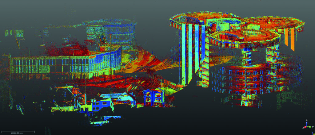
One job – two standout reasons to use the Trimble X12 3D Laser Scanner.
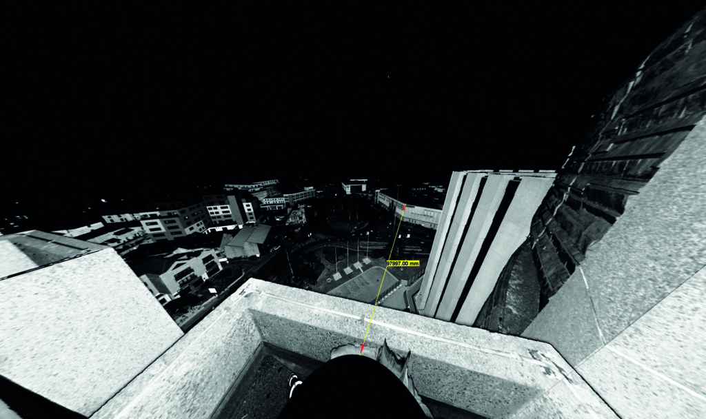
With an extensive survey fleet to choose from, it was the Trimble X12 that Land Development Services’ Scan Technician Andrew Coggan selected for a recent Measured Building Survey of a nine-storey landmark building in Poole.
Download a PDF of the case study here
Experts in the gathering of data since 1969, Wiltshire based Land Development Servicesis a company known for its professionalism (LDS is an RICS Regulated Firm and also a full member of The Survey Association) and its wide range of experience. Over the years, the team has worked on projects as large and varied as raising the roof on a new construction in London and surveying infrastructure for large international sporting events right down to the smallest jobs such as single building elevation surveys and garden projects.
Assisting with the company’s successful reputation in such broad ranging areas is its commitment to investing in groundbreaking survey technology and in particular, Trimble 3D Laser Scanning systems. Supplied by KOREC, the LDS 3D laser scanning fleet includes two Trimble TX8s for precise, HD scanning, an SX10 Scanning Total Station, two X7s for fast scanning and most recently, Trimble’s highest performing laser scanner, the X12.
Responsible for these systems and the main point of contact for any scanning based enquiries or tricky site work is Scan Technician, Andrew Coggan. Familiar with all the survey fleet, it is Trimble’s high-end X12 that Andrew favours for many of the jobs and especially for Measured Building Surveys. Purchased early in 2023, the X12’s high precision data at long range, lightness and size for travelling ensure that it is in almost daily use.
About the Trimble X12 3D Laser Scanner:
Released in July 2022, the Trimble X12 integrates Trimble software for precise data capture and in-field registration (Trimble Perspective) with state-of-the-art 3D laser scanning and imaging hardware technology from Zoller+Fröhlich (Z+F), combining the expertise of two industry leaders into a single solution. The results is a ‘best of both worlds’ combination of Z+F technology and a tried and tested Trimble workflow. The end result is amazingly crisp data. Small for a scanner of this range (0.3 m–365 m) and precision (≤ 1 mm + 10 ppm/m), the compact unit measures just 150 mm (W) x 258 mm (D) x 328 mm (H)) and weighs in at 7.7kg including the batteries. The unit also has a handle is driven via the Trimble T10x Tablet running Trimble’s tried and tested Perspective software which is also common to the Trimble X7 scanner.
One job, two stand out reasons to use the Trimble X12
The landmark nine-storey Barclays House building in the centre of Poole has dominated the town centre’s skyline since its opening in January 1976. Following a decision by the bank to relocate its staff to Bournemouth, LDS was contacted to create elevation drawings of the whole building which is made up of three conjoined octagons. This was followed up by a further request to deliver a roof plan and detailed plans of the three concrete, spiral staircase fire escapes which run down the centre of each of the octagons from top to bottom. The landings were also requested. Whilst Andrew had access to all of the LDS laser scanning fleet, he felt that the X12 was the only option for this job for two reasons:
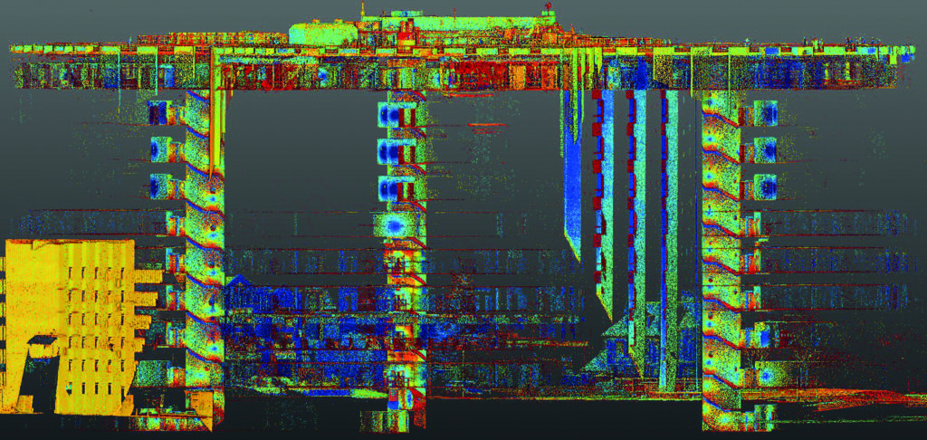
Firstly, the Trimble X12 can scan at a short range of just 0.3m and also has a minimal ‘blind spot’ which is considerably smaller than that of other scanners, to the extent that you can see the tripod legs. This would mean that Andrew could complete the staircase scans far faster because fewer setups would be required – around half as many compared to using an alternative scanner.
Secondly, for this job, Andrew required the distance that the X12 can measure whilst still delivering high-quality, crisp data. The X12’s long range would allow him to link data from the roof to the surrounding buildings at floor level. This would enable registration from the ground to the roof, even on a nine-storey building.
“The distance, speed and smart light features were what attracted me to the X12 and this speed, coupled with the clarity of the scans, blows my mind every day.”
Andrew Coggan, Scan Technician, LDS Ltd
Additional benefits
Andrew says that crucial to the success of the job was the Trimble Perspective software which is used to mange the X12 via a Trimble T10x Tablet. The alternative would be to undertake the work ‘blind’ which could have caused a number of problems when processing the data. Instead, onsite registration means that Andrew could check that he had captured all the data he required before leaving the site.
Overall, Andrew completed 157 scans internally (including the roof ones) and a further 127 externally. He used three setting; low-setting (0:46) for the internals, mid-setting (1:34) for the roof with two set ups using the high-setting window scans in each.
Andrew concludes, “The speed of the X12 coupled with the clarity of the scans blows my mind every day and it’s exceeded my expectations. Additionally, although we’re pretty adept at dealing with any issues we may have on site, KOREC is always there to help us and we have a good rapport with them.”
If you’d like to know more about the X12, please contact our 3D Laser Scanning Sector Specialist, Melvin Penwill at melvin.penwill@korecgroup.com watch our X12 webinar here where you can request an access code.
For product information on the Trimble X12 please visit here or to learn more about customer experiences with the X12, please visit here and here.
We are delighted to share that we have been awarded the prestigious Investors In People & Investors In Wellbeing accreditation – with over 96% of employees agreeing that KOREC is a great place to work!
Launched 30 years ago, the Investors in People programme certifies organisations that perform against a wide range of criteria – including workplace culture, employee engagement, leadership, communication and working practices.
More recently, in 2019, they added the Investors in Wellbeing initiative – which measures an organisation’s commitment to physical & mental wellbeing.
Following a series of employee surveys and focus groups at the latter end of 2022, we were delighted to receive our accreditation at the first time of asking.
The report highlights a high level of satisfaction and engagement across the board – with our people feeling supported, appreciated – and that their achievements are recognised and their ideas listened to.
Amongst the top headlines, over 95% of our colleagues agreed that they felt supported by their manager, and that they trust the leaders of KOREC. Considering the KOREC Values (to be happy, profitable & respected) – we were also delighted to learn that 95% of colleagues agree that we have created a culture where everyone feels respected.
Feeling good – inside and out
Our Wellbeing report also makes for very positive reading – confirming that we have ‘a clear and effective commitment to consider and protect the wellbeing of staff’.
We recognise the importance of maintaining robust physical and mental health – and have a wealth of resources in place to support this. These include our 5-strong Mental Health First Aid team, regular physical challenges, our two yearly parties, our provision of the Plumm mental health portal, an annual Wellbeing Survey, and in-person Wellness Days.
It’s a delight to hear that these initiatives are paying dividends – with several people commenting that ‘the corporate approach to wellbeing is one of the key things that will keep them working for KOREC’.
Despite all the positive news, we’re not resting on our laurels. We’ve committed to the 3-year accreditation, which means we’ll continue to work on improving the standard of life at KOREC – so that we can make it an even better place to work, for all our people.
We’d like to take this opportunity to thank all our colleagues who took part in the surveys and focus groups.
Why not join in the fun?
99% of our colleagues agree that their work is interesting – so, if you’re looking for a new role within a welcoming, nurturing, exciting and supportive environment – why not check out our Careers page?

To learn about the mobile mapping aspect of this project as well, visit here
This case study is all about how KOREC’s clever field data capture app and a Trimble Catalyst cm accurate, low-cost GNSS have enabled National Highways to achieve the same amount of defect work in just one shift whilst saving around £20k on each 5km stretch of carriageway.
The digital revolution has taken hold on virtually every aspect of our lives and each day we witness technology branching out across all sectors and industries as they seek to raise productivity and streamline processes. Whilst the transport industry has in general profited from the digital revolution, specific areas such as highways maintenance are lagging behind, often still using pen and paper methods for data collection and analysis . This is something that National Highways is seeking to rectify with an innovative programme designed specifically for the concrete roads sector.
National Highways is investing £27.4 billion in the strategic road network (SRN) between 2020 and 2025 with digital data and technology being critical to its main objective, namely providing safer, smoother and more reliable journeys for its customers. Consequently, National Highways has been developing methods to enhance delivery efficiency and improve data quality to support long-term decision making.
Over the past three years, KOREC Group has been working closely with National Highways (and its delivery partners, identifying innovative new methods that can reduce both the cost of the works and the impact of construction on roads users and communities. These methods include mass data collection (mobile mapping), digital twins, IOT, augmented/mixed reality, cloud platform (KOREC Portal), machine learning and of course, field data capture (KOREC app).
The third question in our ‘five important questions blog’ is……
4. What’s the scanner’s IP rating or, if the rain comes, will I have to stop working?
Do you use your scanner for TOPO surveys, in construction, in a country where it tends to rain a lot? If so, it’s time to check the IP (ingress Protection) rating of your proposed scanner. The first IP digit relates to the level of protection against solid objects; the second digit relates to the level of protection against liquids. If your scanner IP rating is IP54, it’s imporant to understand that it does not have a closed mirror and you may be risking your scanner by working in conditions it’s simply not suitable for. IP54 means that the scanner is protected against water spray and is suitable for outdoor work, however an IP55 rating means they are suitable for working with in rain.
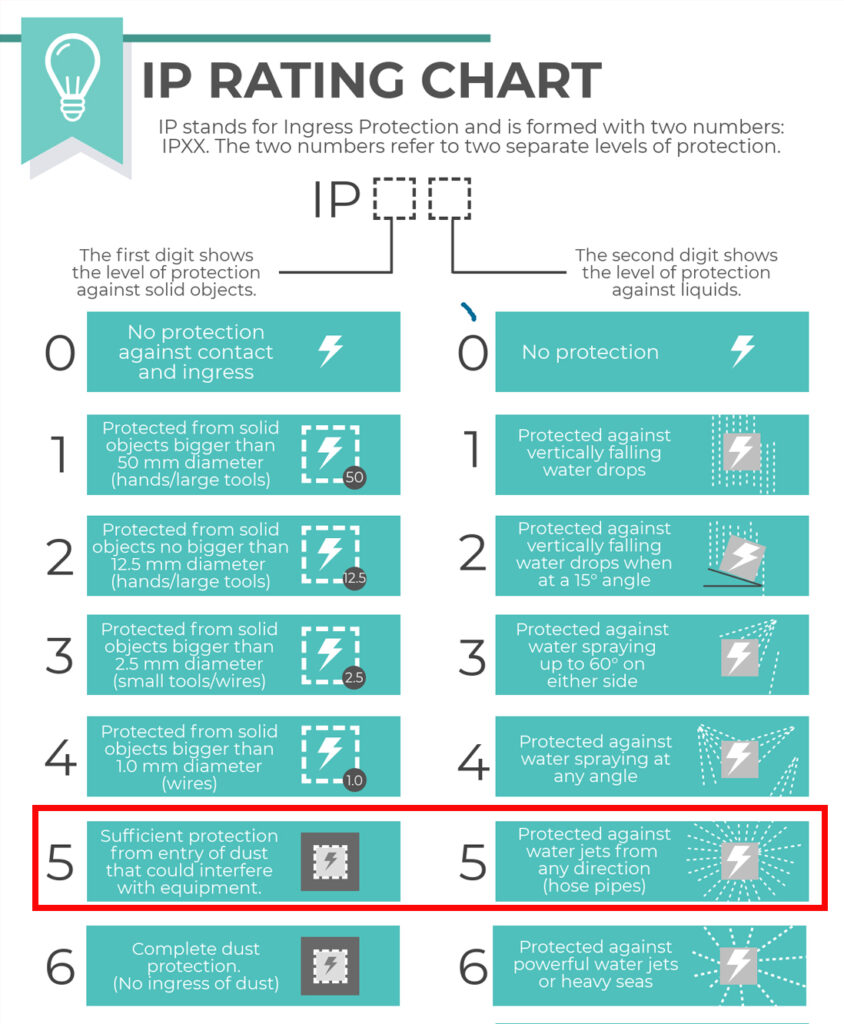
Top tip: The Trimble X7 and X9 are the only scanners suitable for countries where it rains a lot. Fortunately we’ve done some important research for you – on average it rains 151 days a year in the UK! ….and here’s a useful little video.
Keep following this blog to see our fifth and final question
Click here for the answer to our previous question:
1. What is the cost of ownership v. unit cost?
2. What’s more important to you, scan time or total time to project deliverable?
3. Survey grade self-levelling –optional extra or ‘must have’ feature
KOREC Group is delighted to announce that it is expanding its operations with the launch of BuildingPoint UK and Ireland as it becomes the newest partner to join Trimble’s BuildingPoint distribution network.
KOREC Group is an existing, established Trimble distribution geospatial partner with over 50 years of experience working with the construction industry. The addition of the BuildingPoint distributorship to its already extensive geospatial portfolio underlines KOREC’s commitment to expansion which saw the company announce 30 new positions across the company at the beginning of the year.
Over 70% of UK and Ireland construction projects run over time and over budget due to a number of factors including rework, barriers to stakeholder collaboration and challenges to onsite efficiency and productivity. Through this new Trimble partnership, those that work within the construction industry, including users of Trimble Tekla, Viewpoint and MEP software, can now access a full Trimble digital construction portfolio backed up by regional expertise .
This will be delivered through a BuildingPoint team dedicated to bringing tried and tested workflows to the UK and Irish markets. These workflows have been developed to deliver increased productivity, schedule adherence and cost discipline through tighter coordination, improved project transparency and collaboration.
The offering will include assistance with the adoption of digital workflows through a range of task specific software and hardware solutions from general setting out tools to Augmented and Mixed Reality technology and Robotics.
Alan Browne, Group Chief Executive of KOREC and EY Entrepreneur of the Year Finalist 2022 said:
“The creation of BuildingPoint UK and Ireland is the next phase on our journey along with Trimble of helping our partners in Building Construction operate more safely, more quickly and more accurately whilst reducing costs and the impact on the environment”
This dedicated and experienced team will be looked after by Sam Hough (UK) and Kevin Colwell (Ireland) whilst a new BuildingPoint construction focused website for the UK and Ireland has been launched at http://buildingpointukandireland.com.
The dates and locations of regional BuildingPoint launch events will be announced shortly.
ENDS
About KOREC Group
KOREC Group is an established Trimble Geospatial Distributor, one of the largest and most successful in the world and has been for over 25 years. The company has been active in the construction market since its inception in the 1960s.
Since 2019 the Trimble construction side of the KOREC offering has been operating as KOREC Construction. BuildingPoint UK & Ireland joined the global BuildingPoint family in September 2022. This network brings the full range of Trimble Buildings’ solutions to their respective markets – solutions designed to improve your productivity, schedule adherence and cost discipline through tighter coordination, improve project transparency and collaboration.
We’re now part of a growing family of BuildingPoint organisations across the Americas, Europe and Asia/Pacific.
About Trimble BuildingPoint
BuildingPoint dealers represent Trimble Buildings’ solutions—a portfolio of synergistic hardware, software and service offerings that allow users to create and transfer constructible models throughout the DBO (Design, Build, Operate) lifecycle. Trimble is dedicated to transforming the planning, design, construction and operation of buildings through advanced, accessible, intuitive technologies. Trimble Buildings’ solutions provide an unprecedented capability to improve productivity, schedule adherence and cost discipline through tighter coordination, improved project transparency and collaboration—enabling stakeholders to realise greater agility, efficiency and insight.