A project no builder dared to take on… a relentless problem-solving mindset… and the smart use of Trimble technology. Discover how Stephen Napper, Director of MMC Engineer, found the most cost-effective way to deliver a brand-new apartment in a tight, enclosed courtyard with almost no access.
A project no builder dared to take on… a relentless problem-solving mindset… and the smart use of Trimble technology. Discover how Stephen Napper, Director of MMC Engineer, found the most cost-effective way to deliver a brand-new apartment in a tight, enclosed courtyard with almost no access.
Setting out the screw pins carefully positioned amongst the underground services
Just off Knaresborough’s High Street, a small courtyard sits between existing homes in this historic market town. The land belongs to retired local resident Andrew Harvey, whose son Ben owns the neighbouring house. For over 20 years, the plan has been to use this space as part of a wider social housing project, bringing much-needed affordable homes to the area.
However, a series of challenges, each one potentially manageable on its own but overwhelming all together, deterred local builders, bringing the project to a standstill.
Access denied…
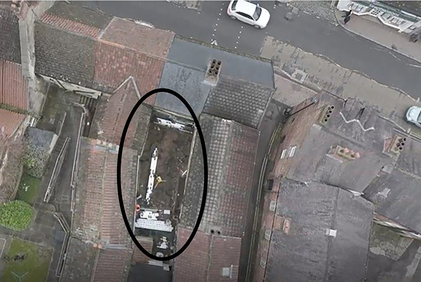
Drone image of the compact site showing the restricted access
Whilst the rest of the social housing project went ahead as planned, the courtyard remained untouched. However, a family friend, Stephen Napper, Director of MMC Engineer Ltd, was determined to assist with this worthwhile project and felt that he had the solution. With his company specialising in modern methods of construction and Light Gauge Steel (LGS), Stephen felt that this would be the perfect project to bring the two together.
From the outset, Stephen knew that if his planned structure was to fit perfectly into the small courtyard then the survey work would have to be extremely detailed with millimetre accuracy, and that he’d also have to tackle the numerous challenges that had deterred the other builders:
Restricted access (1)—Knaresborough is an extremely busy market town and any construction project like this one, located just off the high street, would cause severe disruption, especially during deliveries.
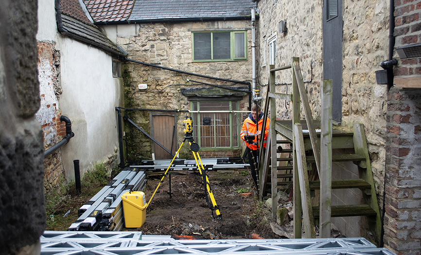
Restricted access (2) —the enclosed courtyard could only be reached via a ginnel and then a ten-foot-long tunnel that was just three feet wide.
Restricted access (3) — Stephen’s original plan to create a steel frame and drop it into the space via another property was thwarted when permission to do this was not granted. Therefore, all materials for his alternative method, a ‘stick build’, would have to be hand carried down the tunnel.
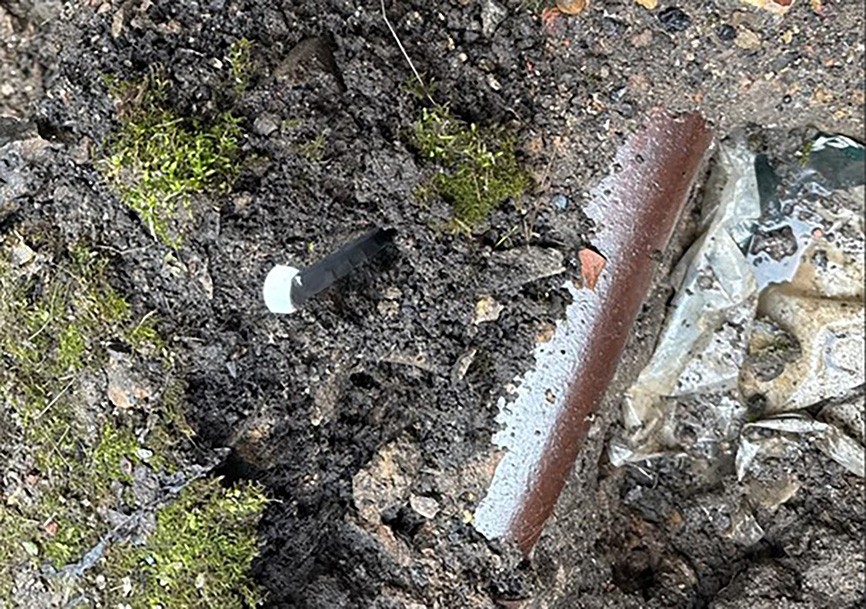
Minimal clearances and bowed walls due to age—traditional survey methods would be too slow and imprecise as well as demanding weeks of work and manual measurements. The centuries-old party walls had shifted over time and had never been perpendicular, even at the time of construction, making offsets impossible. In such a compact courtyard, any new LGS structure would have to fit precisely to maximise the available space. Millimetre accuracy would also be essential for positioning the screw pin foundations among the underground services.
Faced with these challenges, Stephen was aware that the project would be impossible without highly accurate and detailed survey data.
Selecting the technology
Having been aware of Trimble technology since 2000, Stephen was impressed by its potential. Through his other business, Modern Engineered Software Solutions Ltd, which specialises in dynamic and bespoke software solutions for engineering professionals, he had also been collaborating with Trimble as a software developer, creating his own software for designing in LGS, which runs within Tedds—a component of Trimble’s Tekla suite.
Whilst the project is being managed by Andrew and Ben Harvey, it is Stephen who is responsible for designing the steel structure and assisting with the coordination of all the supporting elements including foundations and drainage and of course, providing the survey and setting out data.
He therefore contacted Trimble Construction partner KOREC and in particular, KOREC’s Construction Manager, Sam Hough, to act as an ‘enabler’ for the survey aspects of the job and to guide him on survey technology selection and application:
“I knew it could be done, but not how! I’ve seen the output, but I needed Sam to piece together the workflow with the right tool for each job and I’m still amazed that it all just works so well. Compared to fifty years ago, it’s mind blowing!”
Sam’s recommendations included the following:
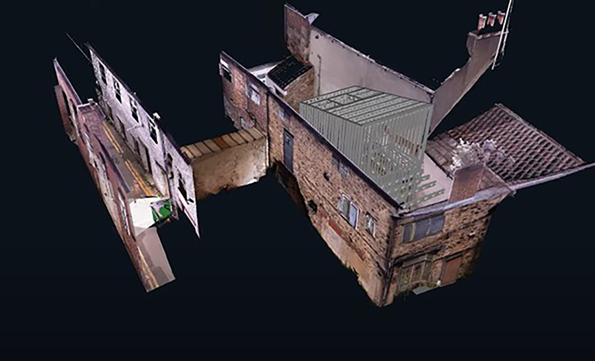
Site survey using the Trimble X Series 3D Laser Scanner
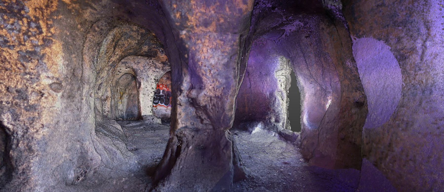
For this aspect of the work, a local survey company, equipped with a Trimble X-Series Scanner, was contracted to carry out the scans and generate a 3D point cloud of the entire site. An IFC model of the scan, including the surrounding walls, was then developed to ensure that the proposed LGS model, once rolled and assembled, would be ‘right first time’ and make the best use of the compact space. This was particularly important, as LGS—much like Lego—functions far more effectively when working with standard component sizes rather than creating customised lengths. (View short video)
Point cloud data generated by the Trimble X Series 3D Laser Scanner
Breaking down barriers with Trimble SiteVision for communication and clash detection
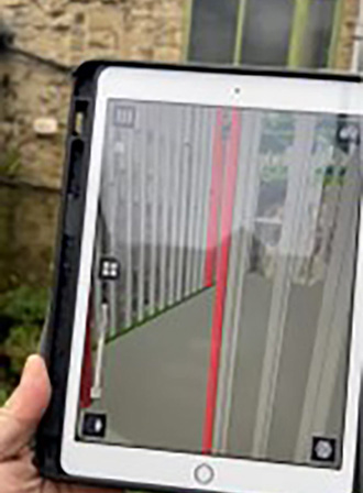
For Stephen, ‘the glue that’s held the whole project together’ is Trimble SiteVision, a tool that uses Augmented Reality (AR) to overlay 3D models onto the real world for easy viewing on a mobile device. This allows users to interact with complex spatial data effortlessly and without the need to interpret maps or 2D drawings. Even for those with a strong visual sense, this removes a significant barrier to understanding the model in context.
On this project, Stephen has found SiteVision to be invaluable:
“You can’t put a price on the benefits of this technology – it’s been a lightbulb moment! The system is child’s play to set up and use, yet the gains are priceless. It couldn’t be easier to pick up and get going, and it means that both Andrew and Ben can see exactly how the finished design will fit into the site. They can either walk around with me to visualise it in person or review everything later via Trimble Connect, a secure, free to viewers, cloud-based collaboration platform. It’s also been a fantastic tool for liaising with the project’s architect. For the price, how can people afford not to use it.”
Beyond enhancing communication among all project stakeholders, SiteVision has also been a game-changer for clash detection. Typically, the LGS structure would be assembled at ground level before being built up. However, in this case, the design risked clashing with one of the bowed walls at multiple points. SiteVision enabled Stephen to verify that the design would fit perfectly before construction even began.
Looking ahead, Stephen believes the benefits of SiteVision will continue to grow. He plans to use it again as a sales tool for his services, for visualisation purposes, and in the future for maintenance by creating a 3D model of underground services and other infrastructure.
Trimble SiteVision enables users to visualise and interact with 3D models on-site
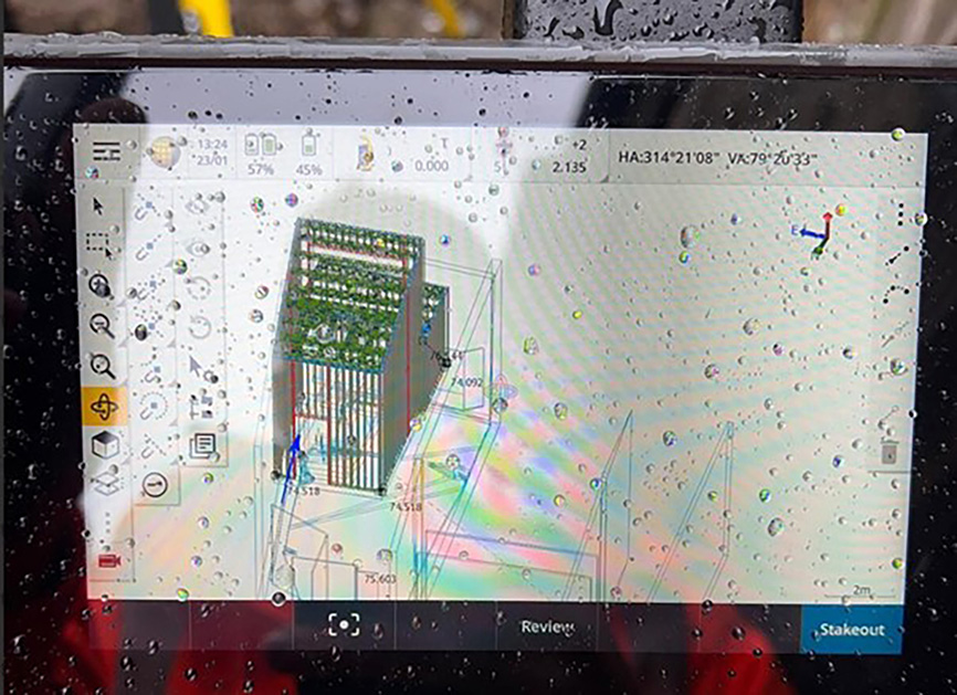
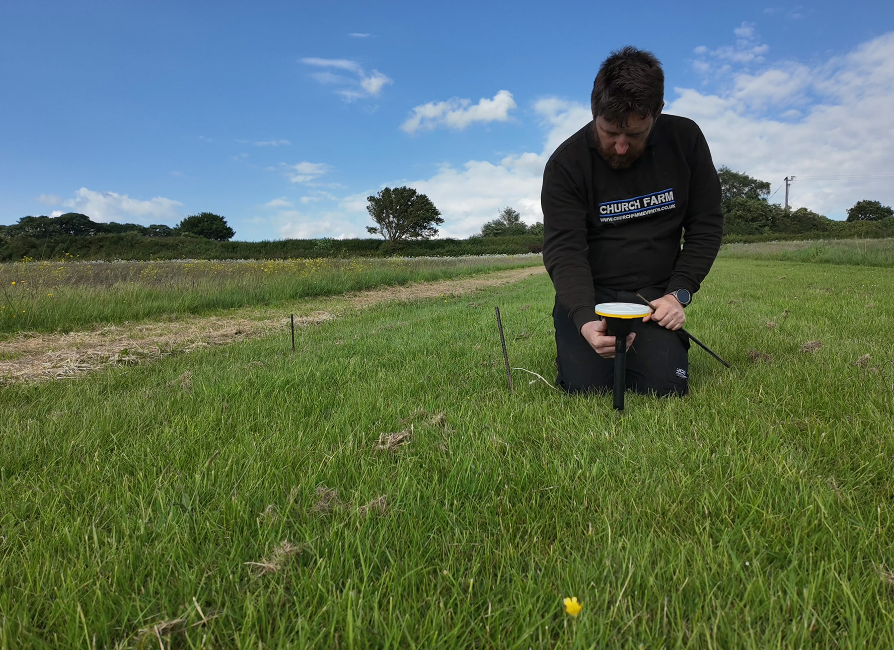
Setting out screw pin foundations with a Trimble S5 Total Station
The accuracy required to set out the screw pin foundations would have been impossible using traditional survey methods such as tapes and offsets due to the lack of straight lines on the site. Instead, using the scan data and SiteVision to show exactly where the foundations needed to be placed, a Trimble S5 Total Station was then used to position setting out pegs with millimetre accuracy to ensure that the screw pins were safely located away from any underground services. Without the Trimble technology, the setting out process would have taken days of careful measurement and arc drawing from one corner to another. Using the Trimble technology, the process took just twenty minutes (Watch a video of the process here
Showing how one of the screw pins would strike a service. The setting out allowed Stephen to conduct calculations and assess that this service needed to be relocated away from the pin location
With preparations complete, here are Stephen’s takeaways
The site is now ready for the installation of the screw pins and Stephen estimates that once the LGS begins to be assembled, construction will be completed and ready for decoration within three weeks. Reflecting on the survey work, he notes:
“From 25 years of following Trimble, I knew this was the right approach. Sam and KOREC have been invaluable in piecing together the workflows and helping to select the right tools. Compared to how we worked just a few decades ago, this is mind-blowing—especially for an industry that hasn’t always embraced new technology. Everything has worked perfectly, the client is impressed, and I’ve felt like a kid in a sweet shop. I can’t wait to see what else can be achieved.”
Stephen’s key points for future projects:
Take ownership of data acquisition from the start. Before commissioning a 3D laser scan, check who will own the point cloud. Ideally, the person pricing the work should commission the scan and retain ownership of the data. In this case, that would be Zeero Build, specialists in the design, manufacture, and supply of Light Gauge Steel building systems for residential and commercial projects.
No job is too small for the technology. Hiring this survey technology or outsourcing the work adds significant benefit to a project. Simply put, if your survey data isn’t accurate from the outset, the knock-on effects can be extremely costly in terms of time, money, and reputation.
The technology is extremely easy to use and understand. Especially Trimble SiteVision.
Undertake the 3D Laser Scan right at the beginning of the project. It can be extremely useful even at the estimating stage.
Undertake the underground survey for drains etc at the earliest possible opportunity. This data can be used effectively in Trimble SiteVision.
Use QR code technology to position the model in SiteVision. Easily done in the field, this speeds things up and increases the accuracy of what you see on the screen.
The reliability of the Trimble X9 Core for 3D laser scanning has made it a go-to tool for the Royal Agricultural University, both in preparing the next generation of land...
Using Trimble Catalyst to accurately map plots on their natural burial ground, Forget Me Not Fields has found a perfect balance between efficiency and tranquillity amongst the wildflower meadows. Download...
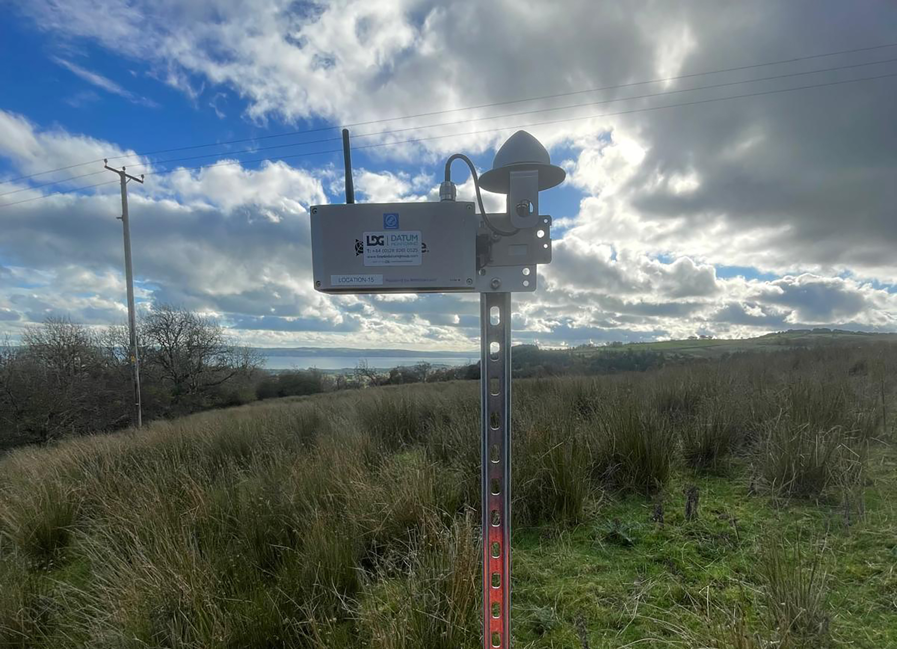
Lloyds Datum Group (now part of SOCOTEC UK and Ireland) has pioneered a landmark project on an abandoned mine site in Northern Ireland. It is the country’s first large-scale ground...