How does the new Trimble Catalyst DA2 receiver measure up against the DA1?
What better way to find out than by putting afforable cm accuracy in the form of the DA2 into the hands of experienced Catalyst user and advocate of the DA1 system, Andrew Stephenson Principal Designer on the Morrison Water Services Northern area Engineering Team.
Andrew was an early adopter of Trimble Catalyst and used the DA1 extensively saving £20k on a recent 1-2cm asset collection project which was nominated for a Water Industry 2021 award for its innovative approach to high accuracy data capture and management.
The set up
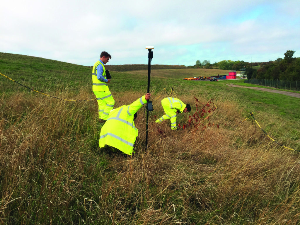
Andrew and Morrison Water Services Surveyor, Asa Blake, used the DA2 in conjunction with a 1cm accuracy Catalyst subscription and their existing KOREC Capture field software running on a rugged Trimble TDC600 Android device (although the DA2 is also now compatible with iOS devices). Drawing on previous experience of how the DA1 worked under different conditions, Andrew was keen to carry out some comparative tests with the new DA2 in the same situations to test its performance and ultimately, it’s productivity improvements.
Three challenging test sites
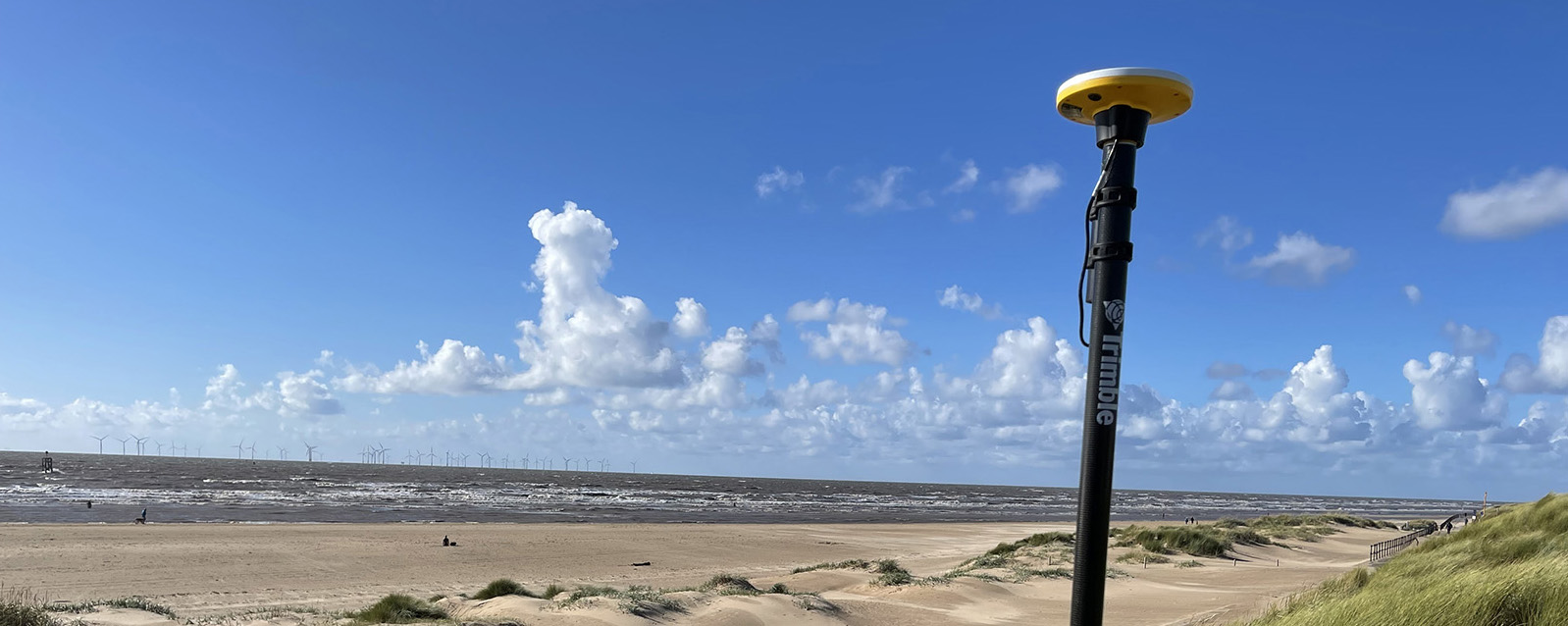
Andrew and Asa opted to test the DA2 in three demanding scenarios which any GNSS would find challenging, firstly, Leeds City centre, secondly under tree canopy and finally in a remote location with no mobile phone coverage.
Here’s Andrew’s report:
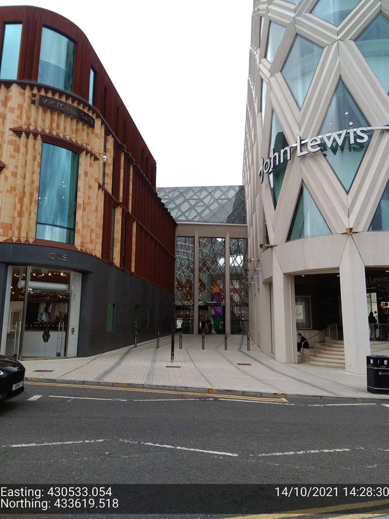
Leeds city centre – built up environment
“In Leeds City centre we were able to achieve 1cm positions. Even next to the John Lewis building where previously we’d been unable to receive a signal at all, the DA2, always delivered an accurate position.”
The technology behind the performance: Trimble ProPoint
Until the launch of the DA2, Trimble ProPoint was only available in top of the range Trimble GNSS receivers. ProPoint delivers better results in harsh GNSS conditions, for example, near tree canopy and in built-up areas.
Under tree canopy
“We tested this scenario under the trees in Cookridge, Leeds – centimetre positions were easily achievable. ”
The technology behind the performance: Trimble ProPoint (see above).
Expect cm positions under tree canopy within 40 seconds!

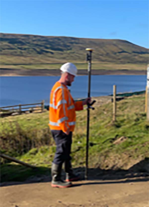
Remote location with no phone signal
“This is a common problem for us so we knew exactly where to test out the DA2’s capabilities for this one. Scar House is situated in the Nidd Valley in North Yorkshire and it’s almost impossible to get a mobile phone signal there. The DA2 again delivered 2cm positions thanks to its ability to receive corrections via satellite rather than via an internet connection. This is a game changer for us.”
The technology behind the performance: Trimble RTX.
The DA2 means that you are no longer reliant on receiving your cm corrections over an internet connection. Thanks to Trimble’s RTX technology you can now get your corrections via satellite (GPS, Galileo, GLONASS, BeiDou, QZSS, IRNSS, MSS, SBAS) which is great for areas with limited mobile phone coverage and internet connectivity.
Conclusion
Andrew’s verdict: “Most of our projects have a specification for 10cm accuracies and in fairness to the DA1 we were often able to work within this spec, but not always. The afforable cm accuracy of the DA2 brings peace of mind and the knowledge that we can always overachieve on precision and in particular,in the three conditions above that previously challenged us.
We’ve also noted some additional benefits with the DA2 – the improved speed is excellent! By the time we’d logged on we were down to 1cm which is a remarkable improvement on the DA1. The DA2 is also Bluetooth enabled which saves battery drain for the phone because there is no need to bother with leads (or water!) into the connection of the phone.
The DA2 delivers outstanding results where we would have never thought possible with the Catalyst technology. We tested this at Scar House Reservoir, which is as remote as it gets in Yorkshire, but the DA2 delivered accuracy of 2cm using RTX which is remarkable!”
You can read about our Trimble Catalyst business case here.
A related case study on knotweed mapping with Catalyst is here and asset data collection here.
Visit our webinar section here for the full details on the new Catalyst system.
If surveying isn’t your main day to day activity but you still have a need for cm positions in your workflow, then the business case for Trimble’s Catalyst is a strong one.
Trimble Catalyst is a revolutionary, GNSS concept delivering positioning as a service to mobile devices. It turns your existing Android or iOS device into a precision mapping, navigation and measurement tool that you can use with any location enabled app or service including KOREC Capture and Esri FieldMaps.
The cost of the Catalyst hardware has been kept low at just £300 per receiver and subscriptions come in a range of choices depending on the number of licenses required and hours used.
However, Trimble Catalyst is not a solution for those who cite survey grade accuracy as the primary part of their working day. Instead, Catalyst has been developed for users who require cm positions as back up to the bulk of their work, for example, the scientist who needs to know precisely where a sample was collected, the utilities engineer who needs to position a valve or the knotweed removal specialist who must know exactly where the plant is located.
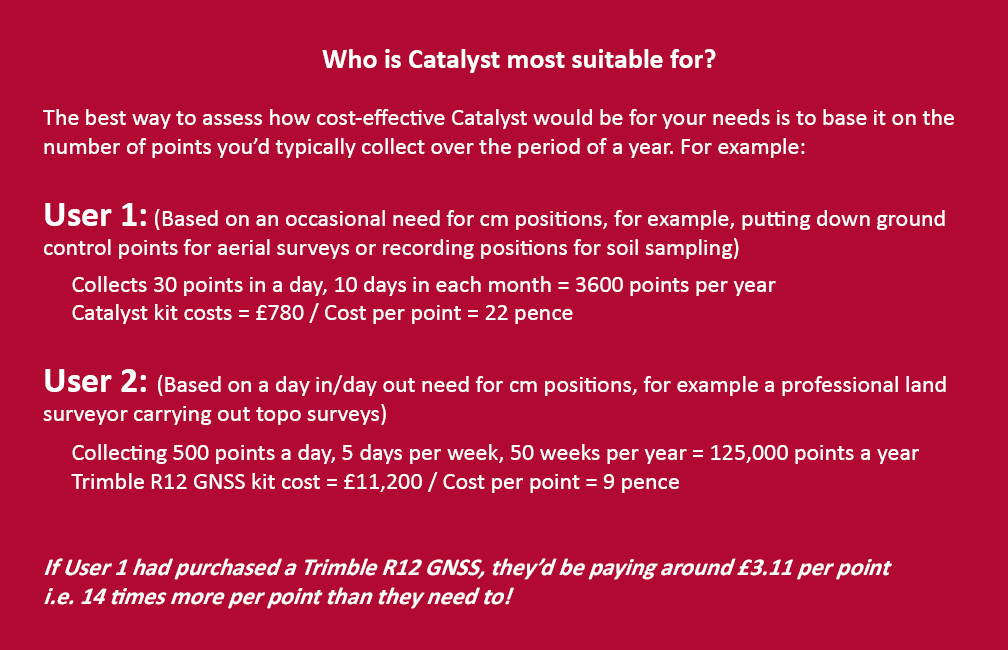
In short, the best way to assess whether Trimble Catalyst will provide the best value proposition for your cm positions is to base it on the number of points you typically over the period of a year.
Case study: DTM Technologies
Typical of the type of user who can benefit from the enormous savings Catalyst delivers is Owner/Director of DTM Technologies, Alan Roberts.
Established in 2014, North Wales based DTM Technologies offers a range of specialist 3D Structural and 3D Modelling Services capturing data predominantly through 3D Laser Scanning and drones. The company uses the very latest in data capture technology (Including the Trimble TX8 Laser Scanner) and provides the high resolution and accurate survey, mapping and environmental information that’s often used to form the basis of any construction (BIM), environmental or engineering project.
With the majority of Alan’s work requiring either a point cloud or aerial imagery, he has an important but fairly minimal need for cm positions. Six years ago, his approach was to purchase a survey grade GNSS system and a license for the corresponding annual correction service. However, he is quick to cite that he is not an engineer or a degree trained surveyor and during the years with this system, he found it expensive to use. As well as the up-front costs for the initial purchase of the hardware, he was also paying an annual correction service charge of around £1,200 p.a. – both large outlays. He therefore sought a solution that would better fit his requirements, spread the cost and offer better value overall.
Alan accordingly purchased a Trimble Catalyst receiver from KOREC and selected the subscription service best suited to his workflow from the options of 60 cm, 30 cm, 10 cm or 1 cm, in this case 1cm. The Catalyst antenna was compatible with his existing mobile phone, easy to set up and required no specialist positioning or GNSS knowledge for use.
The Business case in numbers
Alan states that in a standard working month he may carry out around four surveys that require cm positions and that he can capture the four or five points he requires plus a few check points in one hour of subscription time. He is therefore spending just £10 per site for cm positions, around four times a month. Based on those figures, with the subscription cost spread over a 12 month period, his annual running costs are £480.
| Previously | |
| Hardware: Initial outlay for GNSS system and controller (approx) | £10,000 |
| Annual correction service charge | £1200 |
| Now | |
| Hardware: Catalyst Receiver for use with Alan’s own phone | £300 |
| Subscription: On demand at £10 per hour based on typical annual use | £480 |
Upfront hardware savings ≈ £9600
Annual running cost savings ≈ £760 p.a.
As an experienced user of Trimble Catalyst, even Alan still believes that that system is almost too good to be true. “With Trimble Catalyst, achieving cm accuracy in the field is no longer a niche occupied only by land surveyors, often with the price tag to match. Previously, I was pretty well priced out of the market for this level of accuracy but Catalyst really does bring high cm positions to a mass audience. I’m now in a good position to pass my savings on to my clients which definitely helps in a competitive marketplace.”
Next steps – the new Catalyst DA2
Alan was an early adopter of the Trimble Catalyst system and is already assessing the recently released DA2 receiver.
With much of his work in Snowdonia, mobile phone reception is often compromised and even taking three different SIM cards doesn’t always guarantee a successful connection. The DA2 comes with RTX corrections which means he will no longer be reliant on receiving his cm corrections over an internet connection. Thanks to Trimble’s RTX technology he will be able to get his corrections via satellite.
In addition, the DA2’s ProPoint technology will enable him to pick up his positions in challenging GPS conditions such as near tree canopy.
You can read about our DA2 test here.
A related case study on knotweed mapping with Catalyst is here and asset data collection here.
Visit our webinar section here for the full details on the new Catalyst system.
We’d like to introduce you to a new acronym – PAAS or Positioning as a Service!
The DA2 is the second-generation receiver and antenna for Trimble’s Catalyst service. Simply, Catalyst is a revolutionary, GNSS concept delivering positioning as a service to mobile devices. It turns your Android or IOS device into a precision mapping, navigation and measurement tool that you can use with any location enabled app or service including KOREC Capture and Esri FieldMaps.
Catalyst delivers the most cost-effective method for achieving cm accuracy positioning in the industry.
Subscription based services have grown faster than traditional businesses in many areas of the economy. Trimble is leading the way in PAAS with its Catalyst positioning service.
Of course, here at KOREC we don’t just take things at face value so our Mapping Business Area Manager, Richard Gauchwin, has been out and about putting the DA2 through its paces.
We caught up with him to find out what’s new and what’s impressed. Here’s his verdict:
- Number one has to be the fact that the DA2 is now a full GNSS receiver which removes dependencies on the mobile device which you may have seen with the DA1.
Whilst the DA1 connected via a cable into an Android phone, it was the app on the phone where all the GNSS processing was carried out. In short, processing times etc were limited by the phone’s performance. Not so with the DA2 receiver, it’s a whole different story! The biggest plus is that Catalyst is now so much faster to use. For example using the DA1, it might take you minutes to get a position, with the DA2, we’re talking seconds!
They may look the same and still weigh in at just 330g, but in terms of performance they couldn’t be more different.
2. The DA2 brings you far more flexibility as it now has Bluetooth which allows you to connect wirelessly to your mobile device of choice. And believe me, there is definitely more choice because this now means that the DA2 is compatible with both IOS and Android.
3. The DA2 offers Trimble’s ProPoint technology which has previously only been available in top of the range GNSS receivers. ProPoint means better results in harsh GNSS conditions, for example near tree canopy and in built-up areas. Expect a cm position near tree canopy within 40 seconds.
4. New subscription choices mean even better scalability. Subscriptions have been clarified to accommodate the better accuracies achievable. Choose from 60cm, 30cm, 10cm or 1cm. Trimble have also provided more choice in the number of hours you can purchase including some great options available for equipping large workforces. And of course, you still only pay for what you use.
5. The DA2 means that you are no longer reliant on receiving your cm corrections over an internet connection. Thanks to Trimble’s RTX technology you can now get your corrections via satellite which is great for areas with limited mobile phone coverage and internet connectivity.
6. The DA2 is future proof and will update wirelessly when required.
Who is Catalyst suitable for?
In a nutshell, we describe Catalyst as being a truly cost-effective option for those who require high accuracy positions as a part of their workflow, for example, positioning Ground Control Points for an aerial mapping project, recording the location of soil samples on a construction project or positioning valve or pipe connections on a drainage job. By having access to a cm accuracy system, with no training costs and no outlay for expensive, specialist hardware, Trimble Catalyst is truly a system that can put cm accuracy into the hands of the many different users and/or across large workforces.
We have a great analogy comparing Catalyst to a buying a printer and printer inks. Simply, the hardware costs in buying a printer are minimal, the service, or in this case the printer ink is where the cost lies. If you are just printing out two or three pages every now and again then this is the equivalent of a Catalyst user who can really gain value from the system. If however, you print off many full reports every day, then you will not achieve good value from Catalyst and it’s best to consider a dedicated survey grade GNSS.
If you’d like to see which KOREC customers been using Catalyst then please visit our customer story blog here to read about:
· V.T.O.L Media – establishing ground control points for aerial surveys
· 3LM – a holistic approach to agriculture and the land
· TP Knotweed – rapid response identification and removal of knotweed
· A14 Integrated Deliver Team – fast one-off positions and augmented reality in the field
A related case study on knotweed mapping with Catalyst is here and asset data collection here.
Visit our webinar section here for the full details on the new Catalyst system.
Who needs low cost, on-demand, cm precision data collection?
“A cm accurate GNSS solution at the right price point.” Christopher Cooke of 3LM on Trimble Catalyst
We’ve just launched ‘A Grand Deal’ and it’s our offer of the summer! Mobile, on-demand data collection with centimetre-precision, our KOREC Capture data collection app and the KOREC Portal for review, analysis and reporting of data, all for under £1,000.
Key to this very grand offer and the exceptionally low-priced cm precision is Trimble Catalyst, our on-demand subscription based GNSS. Easy to set up and use, with a range of accuracy subscriptions available, the only hardware you need to purchase is the low-priced antenna.
But who can benefit from this offer? We took a look through our list of Catalyst users and the range is vast! Here are just some of the examples of KOREC customers who have selected Catalyst for their projects (full stories below):
V.T.O.L Media – establishing ground control points for aerial surveys
Operating out of Shropshire, V.T.O.L Media is a company that specialises in aerial photography, video and survey and in particular, construction monitoring. The company is owned by CAA Approved drone pilot, Neil Pepper, who has a mixed drone fleet and takes great pride in using only the latest in high-tech equipment.
The company has recently experienced an increase in demand for survey work with many clients requesting high accuracy aerial surveys. Aware that the use of ground control points would greatly improve the accuracy of any aerial surveys he undertook, and with many of the projects he was working on having little or no established GCP’s, he decided that the ability to establish his own would ensure total confidence in the accuracy of any aerial surveys he carried out.
Having researched various options for the precise positioning of chequer boards in wide open spaces or drains, road markings etc in urban areas, he found a perfect match for his requirements in Trimble Catalyst. Light, easy to use, compatible with his Android smartphone and by far the most cost-effective cm accurate system he could find, Neil says that he can place his GCP’s in under and hour and the cost of his Catalyst cm on-demand subscription is just £10!
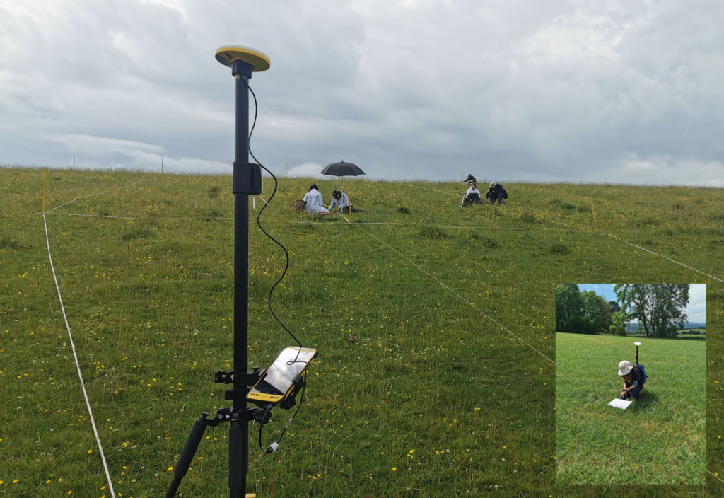
3LM – a holistic approach to agriculture and the land
Yorkshire based 3LM is a member of the Savory Network, a global group that advocates, trains and supports land managers around the world to regenerate land through Holistic Management. 3LM specialises in the provision of educational and advisory services to agriculture and works with farmers who know that something needs to change, but are unsure what. Assisting this approach to change is the precise measurement and data capture of the four eco system processes fundamental to all life – water, minerals, solar energy and community dynamics.
3LM Company Director, Christopher Cooke has a strong background in both GNSS and water management and therefore turned to KOREC in his search for a cm accurate GNSS solution at the right price point. Finding the suggested Trimble Catalyst solution exceptionally easy to use and subscribe to, the company now has two systems comprising Trimble Catalyst, TDC600 logger and KOREC Capture field data capture software.
“The Trimble Catalyst system couldn’t be easier to use. It’s reliable, easy to subscribe to, and most importantly I know that our data is secure with zero chance of it being lost due to storage in both the cloud and on the TDC600. Having cm accuracy on demand allows us to accurately position any areas that we sample from and then navigate back to them at a later date for progress reporting. Additionally, the data management side of the system, developed by KOREC, really is world class.
“We have now achieved our aim of being paper free in the field and have particularly enjoyed how this technology has captured the imagination of the younger generation of farmers and land managers that we work with.”
TP Knotweed – rapid response identification and removal of knotweed
Aggressive, destructive, relentless, Japanese Knotweed is the most invasive plant in the UK and remains a major problem for the construction industry. One company specialising in its removal is Oxfordshire based TP Knotweed, a company that is prepared to invest in technology in order to increase efficiency, whether that be CRM, van trackers or new apps, or in this case Trimble Catalyst.
When TP Knotweed takes on a project, it’s vital that they have very accurate measurements as to the area of an infected site if they are to prepare an exact quote for their clients, along with a map of the project including the position of any boundaries, stockpiles trees etc.
For smaller sites, their solution was a Trimble Catalyst subscription for cm accuracy along with KOREC Capture software which could run on one of their existing Android smartphones or tablets.
TP Knotweed found the Catalyst system quick to set up and easy to use making it ideal for fast turnarounds on these sites. The company also reports that the systems are in use every day and that the quality and quantity of information they are collecting is proving vital for another of the company’s aims, to build a UK wide shareable database of knotweed contamination.
A14 Integrated Delivery Team – fast one-off positions and augmented reality in the field
The £1.5bn A14 Cambridge to Huntingdon improvement scheme was one of Highways England’s largest recent projects and the 34km site provided the contractors involved with a perfect testing ground on which to share new ideas and balance tried and tested technologies alongside new ways of working.
For Skanska’s Mark Lawton, Chief Engineering Surveyor, A14 Integrated Deliver Team, Trimble Catalyst provided two useful areas of investigation for potential use on future projects:
1. Contractors on the A14 scheme often required accurate positioning in ‘one off’ situations. For example, those carrying out borehole testing or soil sampling needed accurate positions either to map a new point or navigate back to a previously recorded one. However, it would not be cost-effective to send a fully trained engineer with survey grade GNSS to carry out these tasks. An obvious alternative was Trimble Catalyst, in this case using its on-demand subscription model with KOREC Capture data collection software running on the contractor’s smartphone. KOREC Capture could offer the contractors fully customisable lists, drop down boxes, mandatory fields etc which again would bring consistency of data, to the attribute information collected as well as cm positioning.
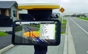
2. Mark also successfully trialled Trimble SiteVision, a system that fuses cutting-edge augmented reality technology with Trimble Catalyst centimetre-precision GPS. The end result is a system that allows you to take your models, drawings and data off the screen and onto your site. Key application areas included utility records, design information, future information and 3D models. In particular, Mark mentioned that on the A14, following the capture of hundreds of km of cable, they needed to know exactly where that cable was for a Permit to Dig. Having the information available visually through SiteVision was hugely helpful in determining where they could excavate.
Additionally, he says that SiteVision provides an easy to understand visual explanation to third parties, such as householders, as to why they are digging in a certain place.
What’s Next?
Take a look at the Trimble Catalyst product page
Watch the official Trimble Catalyst video on our YouTube channel
Make sure you follow KOREC Mapping for all the latest news, info and events