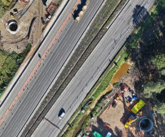
Nexys and Nexys Pro

Nexys and Nexys Pro

A mobile, modular 3D mapping solution designed to reduce time to capture data, increase safety, and drive efficiency for challenging, complex, or dangerous environments.


With Exyn Technologies’ Nexys expect survey-grade LiDAR + proprietary SLAM algorithms that deliver industry-leading data capture speeds, real-time colourisation, on premise post-processing, and instant onsite visualisation in a variety of physical configurations, levels of autonomy, and environmental conditions.


Whether mounted on a drone, vehicle, handheld device, or ground robot (such as Boston Dynamic’s Spot), it adapts to different industries, from mining to construction and geospatial surveying. Nexys provides accurate spatial data without relying on GPS, making it particularly effective in underground or obstructed areas where traditional mapping tools struggle.


Two versions of the system are available, with the Pro version offering higher performance specifications including increased points per second and measurement accuracy plus a longer range.

Full Description

  • Modular Design: Nexys can be configured for handheld use, backpack mounting, vehicle attachment, drone integration, or deployment on ground robots, allowing for flexible data collection across various scenarios.
  • Advanced Mapping Technology: Utilising state-of-the-art LiDAR sensors and Exyn's proprietary SLAM algorithms, Nexys delivers high-speed data capture with real-time point cloud colourisation.
  • Autonomous Navigation: With Autonomy Level 4 (AL-4) capabilities, Nexys enables intelligent, autonomous navigation (without a pilot) through dynamic and GPS-denied environments, facilitating comprehensive mapping without manual intervention.
  • Real-Time Data Visualisation: Equipped with integrated hemispherical cameras, Nexys provides real-time visualisation of colourised 3D point clouds, allowing users to assess data quality and coverage on-site.
  • Rugged Construction: Built to IP67 standards, Nexys is engineered to withstand harsh conditions.

Key Features

  • Modular Design: Nexys can be configured for handheld use, backpack mounting, vehicle attachment, drone integration, or deployment on ground robots, allowing for flexible data collection across various scenarios.
  • Advanced Mapping Technology: Utilising state-of-the-art LiDAR sensors and Exyn's proprietary SLAM algorithms, Nexys delivers high-speed data capture with real-time point cloud colourisation.
  • Autonomous Navigation: With Autonomy Level 4 (AL-4) capabilities, Nexys enables intelligent, autonomous navigation (without a pilot) through dynamic and GPS-denied environments, facilitating comprehensive mapping without manual intervention.
  • Real-Time Data Visualisation: Equipped with integrated hemispherical cameras, Nexys provides real-time visualisation of colourised 3D point clouds, allowing users to assess data quality and coverage on-site.
  • Rugged Construction: Built to IP67 standards, Nexys is engineered to withstand harsh conditions.

Brochure

Product Brochure
New Product Line Sheet
Product Sheet

Interested in this Product?

Call us on

This Product Works with...