KOREC Group is pleased to announce that it has been appointed as the exclusive channel partner in the UK and Ireland for Exyn Technologies, a leading US specialist in autonomous robotics and data collection
KOREC’s focus will lie with the company’s latest 3D mapping solution, the recently released Exyn Nexys. Modular in design, this system can be used as a handheld device as well as an attachment to a drone, ground robot, vehicle, or backpack.
The Nexys is equipped with a LiDAR scanner and Exyn’s proprietary SLAM algorithms, delivering exceptional capture speeds of up to 1.9 million scan points per second, alongside real-time point cloud colourisation.
The system can also navigate autonomously in GNSS-denied environments, featuring what Exyn defines as Autonomy Level 4 capabilities. At this level, drones and robots can explore and map unknown spaces completely independentlyeliminating the need for human intervention.
The introduction of the Nexys range, which includes both standard and Pro models, further strengthens KOREC’s portfolio of mobile mapping systems. This expansion ensures that KOREC continues to meet the growing demand for accurate, easily captured point cloud data with workflows relevant to the UK and Irish markets.
Additional Nexys features include direct export into Trimble Reality Cloud Platform Service (TRCPS), integration of Trimble GNSS solutions for precise georeferencing, adjustment to ground control meaning no drift, real time colourisation and advanced dust filtering.
Mark Poveda, Managing Director – UK & Ireland, KOREC Group said:
“Exyn recognises KOREC as a trusted partner with decades of experience in delivering customer-focused solutions shaped by invaluable feedback. With our strong mutual alignment with Trimble, this partnership is a perfect fit, ensuring that Exyn’s cutting-edge US technology is introduced to the UK and Irish markets by a local expert who understands their customer’s real-world challenges faced on site every day.”
Brandon Torres Declet, CEO at Exyn Technologies said:
“We are thrilled to welcome KOREC Group as our first UK and Irish-based partner. Their commitment to empowering industries to measure, map, and manage the natural and built environment aligns perfectly with our mission. We’re excited to collaborate with a like-minded partner to bring Exyn’s cutting-edge autonomous technology to the UK market.”
About Exyn
Founded in 2014 with headquarters in Philadelphia, Exyn Technologies is pioneering autonomous aerial robot systems for complex, GNSS-denied environments. The company’s full-stack solution enables flexible deployment of single or multi-robots that can intelligently navigate and dynamically adapt to complex environments in real-time.
Download a PDF of this press release here
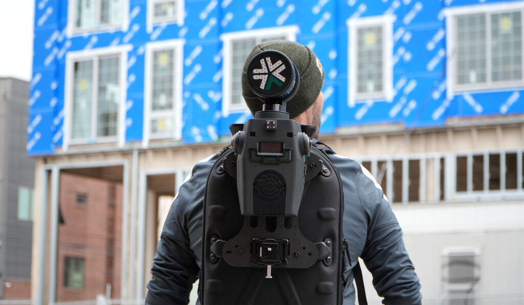
Nexys is a modular system and can be used as a handheld device as well as an attachment to a drone, ground robot, vehicle, or backpack
03/03/2025
How to reliably capture accurate survey data and transform it into intelligence for increased productivity and improved decision making.
KOREC works with a number of utility and fibre companies who have adopted a digital approach to their field data collection and data handling workflows. These companies are now reporting significant benefits from accurately capturing survey data across four main areas; plan, design, build and operate & maintain.
KOREC specialises in tackling the challenges that can impede productivity in all of these stages:
PLAN & DESIGN: Using mobile mapping to enhance productivity for survey, planning and design services
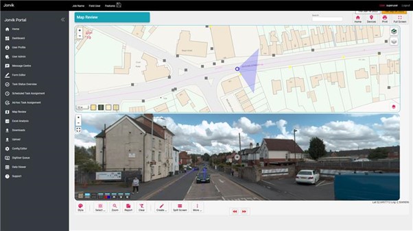
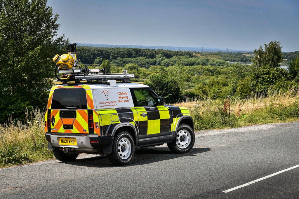
Jorvik Design Group has revolutionised its data capture operations through its investment in a KOREC supplied, vehicle mounted mobile mapping system. Their Trimble MX50 system delivers a very accurate point cloud of the environment along with complimentary immersive imagery and enables Jorvik to create extremely accurate designs without time consuming and labour-intensive site walkovers.
KOREC worked closely with Jorvik to create an enhanced workflow so that clients can now provide a boundary map and all relevant UPRNs (Unique Property Reference Numbers) along with a request that Jorvik plans a design for that network. An initial survey is then driven with the MX50 system mounted on Jorvik’s Land Rover Defender.
Having access to a current, high-accuracy, 3D point cloud means that the Jorvik Design Group can now provide an even better service for its clients through the provision of an accurate 3D point cloud data set for measurements related to costing; a faster design service based on correct asset location and a fully up to date, accurate map of all their assets at the job’s conclusion.
CONSTRUCT: Utility construction company working on new build site
Working on new build sites, the installation of utilities is based on designers’ detailed line drawings rather than OS MasterMap data which has yet to be created for new developments. However, digitising these line drawings to take into the field, sometimes up to 6,000 in a single project, is extremely problematic due to the density of the information contained.
In order to create a new digital workflow, KOREC’s software division, K-MATIC, worked with the client to create an easy drag and drop solution which allows for the easy transfer of these large files from the office on to field devices.
CONSTRUCT: Utility installation company seeking a digitised workflow for greater efficiency and faster payment
KOREC was approached by a company that wished to become more efficient in the field, collecting as-built information. The company required better than 10cm positional accuracy on each connection (as per UK legislation) and also wished to document each connection with attribute information fed live to a secure cloud-based portal. This would enable them to provide proof of connection and bill weekly for work done.
KOREC supplied the company with Trimble Catalyst, a low cost GNSS option (with a choice of subscriptions for different accuracies) and KOREC Capture field data software designed to run on standard smartphones or loggers.

OPERATE & MAINTAIN: a network operator pre-empting potential problems and minimising risk
A utility company has to maintain an existing network including pole inspection and vegetation encroachment across the network. The company approached KOREC who undertook a mobile mapping survey through its Professional Services division. This data, once processed, was analysed with automated routines for poles that were not in the existing inventory and also locations where vegetation could encroach the network and impact connectivity. This allowed them to better manage their assets and foresee potential issues.
Visit KOREC on stand 33b at Connected Britain or look out for our exhibition presentation

The introduction of the Trimble MX50 system will play a large part in enabling the Jorvik Design Group to provide a tailored survey and design service. This will maximize efficiency throughout their telecoms build and network deployment process.
About the Trimble MX50
The Trimble MX50 is avehicle-mounted mobile LiDAR system suitable for companies, such as Jorvik Design Group, who wish to expand their offering to include precise, high-volume data capture technology. The system delivers a very accurate point cloud of the environment along with complimentary immersive imagery and will provide Jorvik with the ability to create extremely accurate designs without time consuming and labour-intensive site walkovers.
Enhanced workflow
KOREC has worked closely with Jorvik Design Group in the creation of an enhanced workflow that will enable it to complete design jobs far faster and more accurately through the use of the high-precision, current, 3D point cloud data collected by the MX50. Previously, the company worked from Google StreetView where asset data could be outdated or inaccurate. This older data often required time consuming back-and-forth site visits from surveyors for asset checking purposes before network design could begin.
With the new enhanced workflow, clients provide a boundary map and all relevant UPRNs (Unique Property Reference Numbers) and request that Jorvik plans a design for that network. An initial survey is then driven with the MX50 system mounted on Jorvik’s Land Rover Defender.
QGIS integration
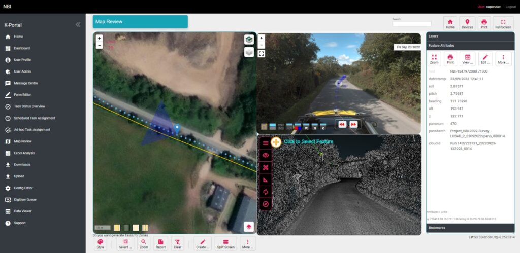
Under the guidance of Jorvik Design Group Network Planner, Mahmoud Ali, the point cloud is then processed and split into smaller jobs for the design team. A KOREC developed portal and plug-in allows the MX50 collected data to be automatically loaded as a layer for immediate use in their QGIS.
This easy integration routine means that the initial design can be viewed on top of the point cloud in a pre-defined layer. The same data can then be worked on all by all Jorvik designers simultaneously.
Client benefits
Having access to a current, high-accuracy, 3D point cloud means that the Jorvik Design Group can now provide an even better service for its clients through the provision of:
Accurate 3D point cloud data for measurements related to costing
A faster design service based on correct asset location
A fully up to date, accurate map of all their assets at the job’s conclusion.
“We invested in the Trimble MX50 system because we are always looking to continually develop and improve our approach to surveying & design and felt that this would allow us to step out amongst the crowd, in an ever growing and rapidly moving sector. KOREC has assisted us in tailoring the MX50 specifically to suit the telecoms market and to specific client requirements, which has been instrumental in our growth as a business.
Charlie Farley, Jorvik Design Group, Director
“By investing in such an advanced piece of hardware, we feel that we are extremely well placed to deliver exceptional data at pace, whilst ensuring that the information captured is up to date. This is critical to our design output and has allowed Jorvik to cover vast areas across the UK in a very short space of time. This system has proven to be invaluable to Jorvik and by using this cutting-edge technology, we feel that we are the market leader in the delivery of surveying and design services within the telecoms sector and keeps us one step ahead of the competition.”
“Mobile Mapping is now a recognised and accepted technology playing an important part in the digital strategy of many major businesses including a number of fibre optic installation companies. Jorvik Design Group is the first in the UK to invest in a Trimble MX50 system and KOREC has been delighted to be a part of that process, from initial trials through to assisting with an enhanced workflow and the delivery of training.”
Richard Gauchwin, KOREC Group Business Area Manager – Mapping & GIS
If you’d like to find out more about the Trimble MX50 Mobile Mapping system, please contact your local KOREC consultant, or use the details below;
Call UK Sales: 0345 603 1214
Call Ireland Sales: 01 456 4702
For anything else, view our contact page.
Congratulations to Atkins, the company that has been appointed by the government’s Geospatial Commission to help create a digital map of underground pipes and cables throughout the UK.
The map will be known as the National Underground Asset Register (NUAR) and is being developed by Atkins alongside mapping agency Ordnance Survey and geospatial data management leaders 1Spatial.
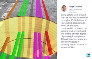
Designed to revolutionise construction and development across the country, the Geospatial Commission NUAR map release states that, “The economic cost of accidental strikes on underground pipes and cables is estimated to be £2.4 billion per year and one cause is inaccurate information on the location of buried assets. Once operational, NUAR is expected to deliver around £350 million per year in benefits by avoiding accidental asset strikes, improving the efficiency of works and better data sharing.”
The project is about to enter its build stage, a process estimated to run for three years. This is a large and ambitious undertaking, but the geospatial industry is highly progressive when it comes to the development and adoption of technology for field data capture and verification and the NUAR project will no doubt make excellent use of these developments.
Here at KOREC we can’t help but make three suggestions for technology that could be beneficial on a project of this nature:
Mobile Mapping + GPR Survey
The KOREC Professional Services team has just completed a roads project that saw them carry out a Trimble MX9 vehicle mounted mobile mapping survey at the same time as an underground mapping survey using Ground Penetrating Radar (GPR). This dual-purpose survey was completed with a single pass (reducing emissions and keeping boots off the tarmac) and produced a data set suitable for many applications from asset management to road conditions surveys to pre site risk analysis.
The Trimble® MX50, offered for sale by KOREC, is a practical field-to-finish mobile mapping solution for asset management, mapping, and road maintenance. The system delivers a very accurate point cloud of the environment along with complementary immersive imagery providing substantial gains in productivity in areas such highway management, utilities and local government.
Augmented reality
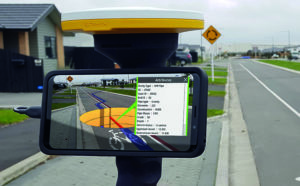
Imagine if you could see things that are hidden or that don’t actually exist yet. Trimble® SiteVision™ brings geospatial data to life so you can easily visualise, explore and understand complex information with unrivalled centimetre accuracy, right from your mobile device.
Ideal for use before and after in an application such as the NUAR project, SiteVision is proven technology used for the visualisation of underground assets by organisations such as Balfour Beatty Plc, O’Brien Contractors and the A14 Integrated Delivery Team.
Trimble SiteVision couldn’t’ be easier to use and is highly portable for use on site.
Centimetre accurate, low-cost positioning for large workforces
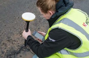
If you have a large workforce that requires centimetre positions to support its main line of work, then Trimble Catalyst provides an excellent way of enabling a varied workforce of non-surveyors to achieve the high accuracy that utility positioning requires, but without the costs of a high-end survey grade GNSS.
Trimble Catalyst is a revolutionary, GNSS concept delivering positioning as a service to mobile devices. It turns your existing Android or iOS device into a precision mapping, navigation and measurement tool that you can use with any location enabled app or service including KOREC Capture and Esri FieldMaps.
The cost of the Catalyst hardware has been kept low at just £300 per receiver and subscriptions come in a range of choices depending on the number of licenses required and hours used. However, Catalyst is more suitable for some users than others and our business case post on this is well worth a visit.
It’s also the perfect partner for our KOREC Capture Utility module for field data capture specific to the utilities sector.
If you’d like to find out more about any of these technologies, please contact:
Call UK Sales: 0345 603 1214
Call Ireland Sales: 01 456 4702
For anything else, view our contact page.
On a recent mobile mapping mission, KOREC employee Graham Beckford was lucky enough to pass not one, but two pre-historic jewels in England’s crown – Stonehenge and the Uffington White Horse.
Despite dull and grey conditions, there was no missing the new Professional Services vehicle as it drove up alongside the ancient stone circle – one of Europe’s most recognisable and oldest monuments built around 5,000 years ago.
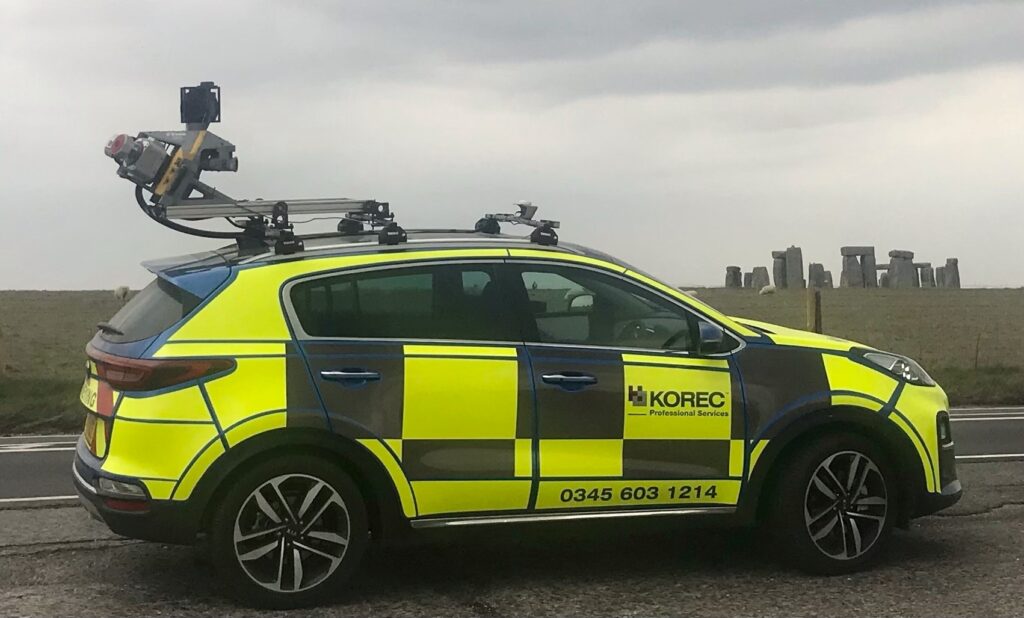
Mounted on top of the car is the Trimble MX9, a LiDAR based mobile mapping solution which rapidly captures pointclouds and images for highway surveys. A mobile mapping device such as the MX9 can be driven at normal speeds to capture survey data without the disruption of road closures.

Inclement weather persisted for Graham’s mission as he passed from Wiltshire and into Oxfordshire, specifically the Vale of White Horse to photograph the 3,000 year old hill monument – just visible in the background of this photograph.
Have you been on any mobile mapping adventures recently? Why not submit your pictures to our monthly KOREC Photo Competition by emailing marketing@korecgroup.com.
If you’d like to find out more about mobile mapping, our professional services division or anything else do not hesitate to contact us.
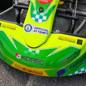
How KOREC are powering a Guinness World Record breaking attempt
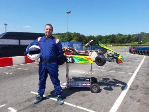
Ian Williams is a man on a mission. Over the weekend of 7-8th August, he’ll be attempting to smash the Guinness World Record for the furthest distance travelled in a go kart in 24 hours, at the Teesside Autodrome British 24hr Challenge.
The current record stands at 945 miles, while Ian hopes to smash through the 1,000 mile (1600km) barrier – as well as raising £15,000 for charity in the process.
So how do you go about planning such an exhausting mission? Well first things first, Ian (not to mention Guinness) needed to know the precise distance of the track to be driven – which is where KOREC come in.
Whilst the official track length is stated as 2.1km, Ian needed a precise measurement – both to satisfy the stringent demands of Guinness, and to pace his race.
Ian searched around local survey companies before he was advised that KOREC might be able to assist with obtaining an accurate track measurement. Never ones to shy away from a challenge, we immediately knew this was a job for the MX9 and the Professional Services team.
Flash forward to 1st July, and our team met with Ian trackside. It took a matter of minutes to drive the race-day circuit layout in the MX9 scanning vehicle, capturing millions of measurements of data points of both track position, and elevation.
The data was processed back in the office, producing a dense 3D point cloud of the circuit, allowing for a centre-line to be produced – which came in at 1.64km in distance – almost half a kilometre shorter than the stated distance.
0.5km may not seem much to you or me, but when you’re planning to drive over 1000 miles, it works out at an additional 214 laps of the circuit – knowledge that means the difference between success and failure.
As well as providing these crucial measurements, the Professional Services team have generated beautiful 3D visualisations of the circuit, which have been incorporated into Ian’s marketing video – a vital piece of promotion for his charity drive.
Ian is hoping that his record attempt will raise £5000 each for his three chosen charities – Shelter, Papyrus (prevention of young suicide) and the Lincolnshire and Nottinghamshire Air Ambulance.
So how is Ian gearing up over these final weeks for this massive challenge?
“I’ll be focussing on building up my stamina by taking part in track days. I’m also conditioning my neck muscles, as they’ll be coping with around 70 tonnes of pressure over the 24-hour period. I’ve also upped my water intake, ensuring I am well hydrated, and getting used to a liquid diet”
(Ian won’t be consuming food during the attempt)
Whilst this is a solo attempt, Ian is far from alone. Upwards of 100 other racers will be on the circuit, with Ian hoping his kart’s bright livery will help him stand out from the crowd. He’s also got the support of the Haase UK Kart team, who have learnt him the kart, and his very understanding partner Alyona!
All of us at KOREC wish Ian the very best of luck in his challenge!
If you’d like to support Ian’s chosen charities, you can do so via his Justgiving page; https://www.justgiving.com/team/British24hoursolo
Article Links
Teesside Autodrome – British 24hr Challenge
Guinness World Records – Current World Record