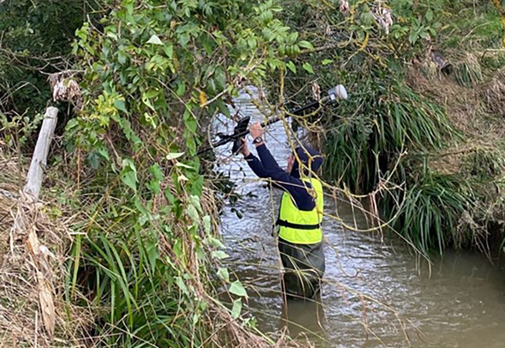
A maze of underground defensive tunnels was the perfect training location for the Royal School of Military Engineering to team up with KOREC and compare Trimble X9 3D Laser Scanner technology with traditional total station techniques.
Purpose: Invited by Steve Coates, Head of Engineering Surveying at the Royal School of Military Engineering Surveying and Sergeant Niel De Witt, Senior Military Instructor, to deliver Trimble X9 3D Laser Scanning training in a tunnel
Training delivered by: Melvin Penwill, Scanning Specialist and Sarah Cummings, Training Specialist, KOREC
Location: Underground tunnels at Fort Amherst, Chatham
Additional benefits: Useful comparison of laser scanning compared with traditional total station and traversing methods. What had taken a week traversing with a total station was achieved in just a few hours with the X9 and included far more data
Stand out X9 features: Easy of use, in-field registration for visual checks on site, easy auto-levelling and excellent performance in the dark
A few years previously, KOREC had trained the Royal School of Military Engineering students on the Trimble X7 3D Laser Scanner. This time around, along with TSA, our scanning specialist Melvin Penwill and training specialist Sarah Cummings were delighted to accept an invitation from Steve Coates, the school’s Head of Engineering Surveying, to return with the Trimble X9, which offers a longer range, increased accuracy, faster scanning and enhanced imaging.
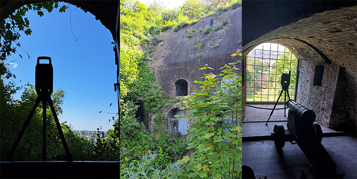
The location for the tunnelling workflow training was Chatham’s Fort Amherst, Britain’s biggest Napoleonic Fort with its maze of underground tunnels and features making it the perfect testing ground for the X9.
After arriving at the site, a sports pavilion was scanned with the X9 and a colourised pointcloud generated for a speedy demonstration of what could be achieved. The X9 was then taken to the tunnel area. Control had already been established earlier in the week when the trainees had traversed through Fort Amherst and then undertaken a total station topo survey of the tunnels. With KOREC on site, the same work was then completed using the Trimble X9.
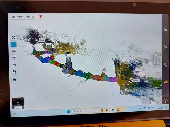
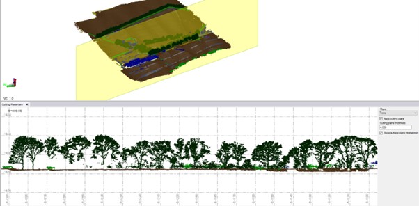
Scanning the Tunnel
The instrument was controlled by a Sergeant using a Trimble T10x Tablet running Trimble Perspective software and his first set up, guided by Melvin and Sarah, was at the mouth of the tunnel. Once in inside, the massive tunnel complex provided a perfect showcase for the X9’s functionality taking in a 20m shaft to measure its height, a steep staircase, hall and areas with very little detail and not much overlap which would be a good test for the Perspective software’s in-field registration for a visual check that nothing had been missed.
As well as surveying the tunnels, the twenty-metre-high shaft was scanned using the indoor mode fifty second scan in order to achieve sufficient detail in the shaft and capping. The scanner’s laser was used to shoot the control points and an area scan completed where the cannon was positioned.
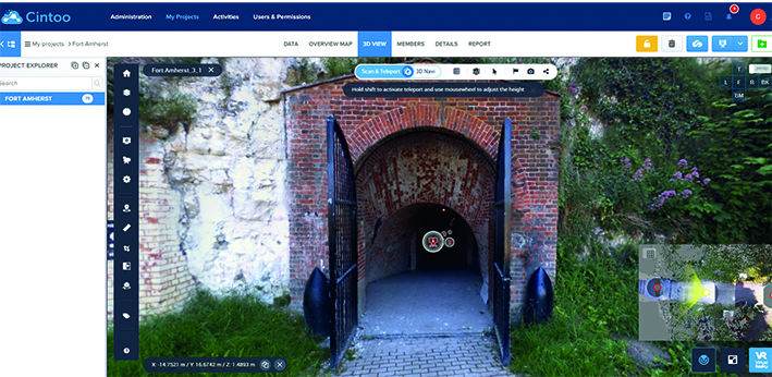
Cintoo Cloud turns laser scans into mesh-based reality capture data perfect for sharing
Following the seventy-five setups needed to complete the maze of tunnels, undertaken over a period of just a few hours, the afternoon was spent in the classroom where Melvin demonstrated Trimble RealWorks software for point cloud handling and showed the scanned data on a projector and answered questions.
Both Sarah and Melvin appreciate the positive feedback from the trainees and thoroughly enjoyed themselves as well!
For further information on the Trimble X9 or KOREC Training, please contact us here.
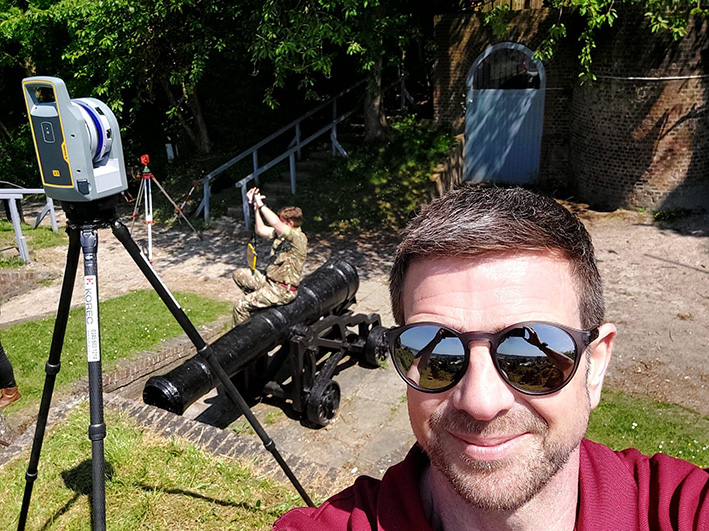
KOREC’s Melvin Penwill at Fort Amherst
By following all the industry guidelines, nationwide survey company Survey Solutions is sending out a strong message to equipment thieves: ‘If you steal from us, we will pursue every angle to reclaim that instrument.’ The result is a Trimble S5 Total Station tracked and recovered from Poland.
Whilst survey equipment theft remains rife as recently reported by The Survey Association in one of its regular updates, on a more encouraging front, an instrument stolen from Survey Solutions has been reclaimed from Warsaw in Poland.
For Survey Solutions’ Survey Manager, Reece Maycey, the tracking and recovery of this instrument has proved to be a satisfying experience and one that throws some light on what happens when a piece of equipment is stolen:
“Our company has experienced instrument theft in the past and we have several cases currently under investigation. However, this time, our efforts have led to a successful outcome and the experience of dealing with the relevant parties in the recovery of the instrument have been extremely positive starting with a receptive response from the local police through to the help we’ve received from TSA, DeterTech and the UK Police Task Force that deals with construction and agricultural equipment theft.”
Whilst Survey Solutions protects its equipment in a number of ways (including the use of Trimble’s Sentinel real-time device tracking solution and padlocks and cables) and ensures that all its surveyors are aware that remaining safe during a theft is the number one priority, inevitably incidents still occur. In this case, the KOREC supplied Trimble S5 Total Station was stolen from the roadside in a quiet dead-end street in East London whilst the surveyors were 50-60m away.
The local police were immediately alerted and at the same time, Reece used the Trimble Sentinel app to track the instrument’s movement in real-time. The tracking positions led to a nearby block of flats and although the police were on the scene promptly, it was impossible to pinpoint which flat the instrument was stored in.
Significant progress
However, three weeks later, the signal became active again allowing Reece to track its movement around the Warsaw area and at this stage significant progress was made. Through TSA, Survey Solutions were put in touch with the intelligence-led security solutions company DeterTech (formerly SmartWater), who work in alliance with TSA to coordinate a response to thieves who persistently target surveyors.
Reece was able to provide DeterTech with full details on the instrument, its serial number, type etc to identify it along with real-time positions in Warsaw where its frequent movement indicated it was being used on regular surveys in the area. DeterTech worked in conjunction with a police officer on the UK task force specialising in organised crime of the theft of construction and agricultural equipment who liaised with police in Poland.
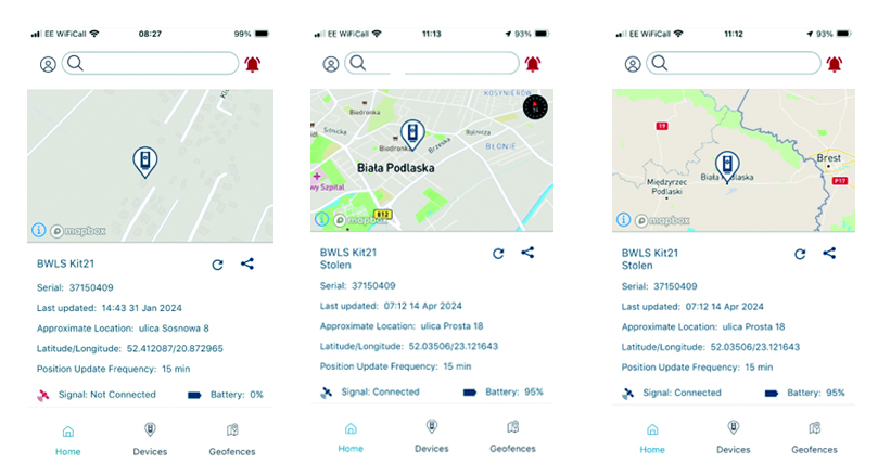
The instrument was recovered by Polish police and is now in the possession of Survey Solutions’ insurance company.
For Reece Maycey, the success of this recovery underlines how important it is to collaborate with industry partners to provide the information that enables not just the recovery of instruments but the avoidance of theft in the first place. This can be assisted through the sharing of information and vigilant business practices that include being alert to unusual vehicle behaviour around a site and being prepared to bring in security in ‘hot spot’ theft areas that can be identified with TSA information.
TSA advice on keeping your equipment safe
About Sentinel: Protect your Trimble Total Stations in the field:
- Trimble Sentinel is app based. If your instrument is stolen, it can be tracked immediately from the field.
- Trimble Sentinel uses the 4G network and locations can be pinged via any available mobile network
- Trimble Sentinel is retro fitted inside the Trimble Total Station and cannot ‘just be taken off’. It also has its own internal battery – charged during general instrument use, it will continue to ping signals for a period of time. In the event of a theft, call KOREC and we will talk you through best practice to ensure you can track this signal for as long as possible.
Sentinel is available as an after-market add-on for Trimble S Series and C5 instruments. Its usefulness goes far beyond retrieving missing instruments. It can help you find teams in the field at any given time. It also contains a G-force sensor that sends alerts to users to check instruments for calibration errors or damage when they’ve been dropped or have endured a rough ride…And remember, the Sentinel tracking module is installed inside the total station by KOREC, an authorised Trimble Service Provider.
Download the Sentinel PDF here
For more information on Sentinel, please call your regional KOREC consultant or contact us here.

Following a number of recent test flights, KOREC’s Darrell Theobalds reports back on where the WingtraOne Gen II scores high, what’s on his wish list and what he truly rates.
Does the WingtraOne deliver?
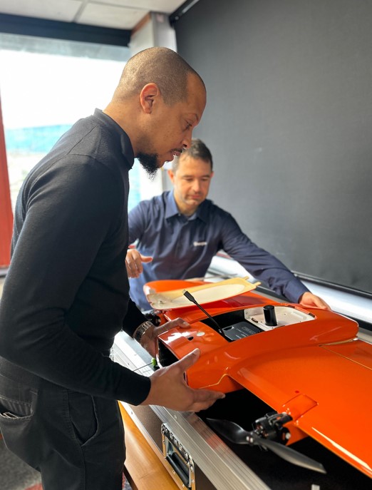
For KOREC’s sector specialists, the good news is that they always get their hands on a new addition to the KOREC portfolio before anyone else! This time it’s the turn of our drone specialist, Darrell Theobalds, who has been putting the WingtraOne GEN II through its paces.
KOREC has recently become a Wingtra partner to further strengthen the existing KOREC fixed wing portfolio and Darrell, with his extensive experience supporting and training our drone users, understands better than anyone the challenges drone operators face in the field as well as what’s required to overcome them.
Developed in Switzerland, the WingtraOne GEN II is a premium surveying drone aimed at those who seek consistent high-quality drone data and comes with the tag line ‘Map Faster, Map Larger, Map Anywhere’.
Does it deliver? Darrell reports back on his testing:
How I tested the WingtraOne GEN II
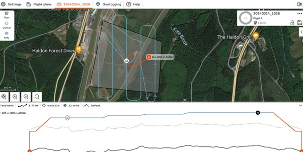
I’ve completed six flights in two separate locations so far with the WingtraOne; three with the new LIDAR payload and three with the RGB61 high-resolution mapping camera. Two of the flights with the LIDAR were in wet conditions and the other was on a very windy day. With the RGB camera, we undertook two flights on sunny, calm days and again, one in very wet weather.
A flight with the WingtraOne and LIDAR payload lasted 4mins 40 sec producing a 183 pt/m2 point density cloud and coving an area of 13ha. The point cloud size was 470mb whilst processing time in the Wingtra LIDAR app took 10 minutes.
First Impressions
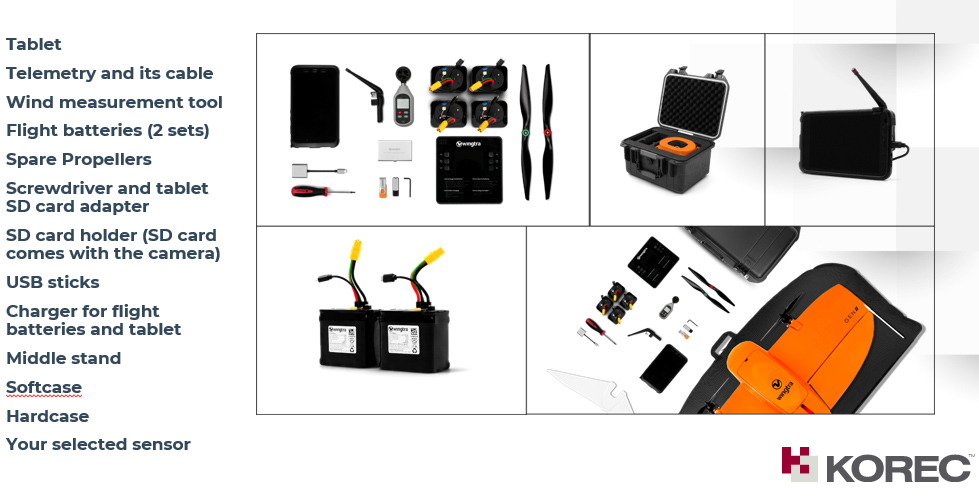
Before we get into what’s included with the WingtraOne, it’s worth mentioning the case itself – this is professional packaging! The drone comes in a robust, thoughtfully designed container guaranteeing the safety of both the drone and its sensors during transport. The inclusion of a hardcase for shipping and soft backpack carrier for easy transportation means you’re equipped to take it on a plane, or venture across remote countryside.
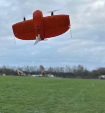
With the case open, the first thing to note is that the Wingtra is bright orange for easy spotting and has a sleek and modern design reflecting its professional-grade capabilities. It’s also extremely compact. This is good to see because power lift drones can be complicated instruments, so this sleek design definitely showcases the ingenuity that’s been put into its development.
What’s in the box?
Once you open the box it’s a comprehensive set up. The standard WingtraOne GEN II package comprises not only the drone itself but also a complete set of essential accessories. This includes four batteries, a smart charger, a ground control station Samsung tablet, communication modules, an anemometer, and various accessories for data transfer. Altogether, it’s a carefully curated selection of accessories that are essential for the field data collection.
Getting set up
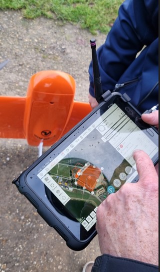
Setting up the WingtraOne for flight is typically straightforward, thanks to user-friendly instructions, an online knowledge base resource repository of eLearning tools and intuitive design. To start up flights with the Wingtra, you need to set down on a level surface parallel to the wind, insert the middle stand, insert the payload and connect the battery. Then plan your flight, go through the Wingtrahub check list and off you go.
Preparing to fly – intuitive software
WingtraHub is the Windows software for PPK image geotagging and desktop flight planning and has a simple flight check wizard. This means there is limited chance of error as you would not be able to take off if the initializing process was compromised or if you missed a step.
The Wingtrahub allows the user to plan area and corridor flight import mission parameters from KML and view this mission plan against the terrain. Again, a well-engineered thought-out application.
VTOL! Abolutely one of my Top 5 features
The benefits of fixed-wing and multirotor drones with VTOL (Vertical Take-Off and Landing) capability always appeal to me as I have had a fair number of challenges with sites that are extensive but have limited take-off and landing location.
Powerlift drones like the Wingtra enable vertical take-off and landing like a multirotor drone while also having the efficiency of a fixed-wing aircraft during flight. I have flown fixed wings for the past 12 years and the challenge has always been landing and taking off at confined sites, especially when the landing location has obstacles and you are restricted because you need to land into the wind.
The time spent trying to find the safest location to take off and land can now be spent flying. With the additional functionality of pausing and manually landing like a rotary, it’s really the best of both worlds. Only last week, at a Yorkshire racecourse, I had a flight planned with winds gusting at 30mph and averaging 17mph. I was able to take off and land with no issues. The updated Wingtrahub software and manual override for land, made landing in these type of winds very controlled and safe.
High precision mapping – sensor choices
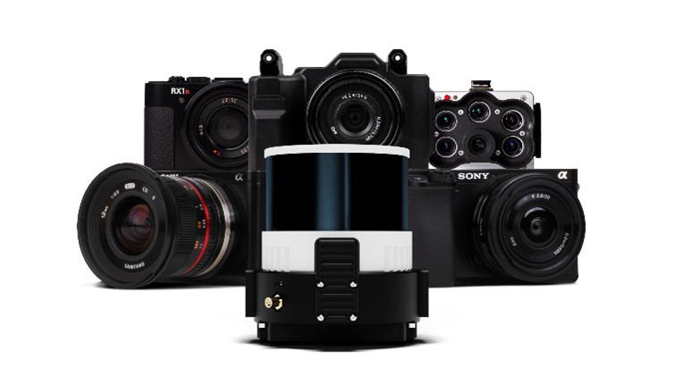
WingtraOne is equipped with high-resolution cameras like the RGB61 and advanced sensors like the multispectral mica sense and Wingtra LIDAR to capture detailed imagery and data for real-world mapping and surveying purposes. This combined with the PPK base data can provide users with deliverables up to 1cm accuracy. I used both the RGB61 and the new LIDAR and was impressed with the results, they both performed remarkably well in windy conditions with no downwash or blurry images. Their solid performance also gave me total confidence that I was achieving one of the things that can save the most time on a job, ‘getting it right first time’.
In the air – what I liked
Long Range and Endurance:
With its fixed-wing design coupled with vertical take-off, WingtraOne can cover large or small areas efficiently in a single flight.
Thanks to its impressive flight range and endurance, the Wingtra can efficiently map vast areas without the necessity for frequent battery swaps or recharges. Moreover, it’s not limited to large expanses; it’s versatile enough to capture smaller sites as well.
Post-Processing Software Integration:
The exports from Wingthra Hub can be processed using various photogrammetry and GIS software packages, outputting the standard point clouds in LAS or Laz, the mesh file in OBJ, your Orthomosaic in Geo tiff or jpeg. Typically, all I need is a combination of Pix4D and Trimble Business Center to accomplish my tasks.
Impressive Performance:
I was impressed by WingtraOne’s performance in the field, including its long flight endurance, high-quality imaging capabilities, and reliable autonomous flight missions. I flew in high gusts of up to 30mph and landed in winds over the max of 17mph which meant the unit can be pushed to its limits while still providing good data. As I mentioned, the lidar sensors and RGB61 sensors performed remarkably well in windy conditions with no downwash or blurry images.
LIDAR camera impressions
February of this year saw the introduction of Wingtra LIDAR. Integration of LIDAR systems typically involves mounting the LIDAR payload onto the drone’s payload bay and ensuring proper integration with the drone’s flight control system and data capture workflow. This will involve some calibration to prevent distortion and incomplete point clouds.
Contrary to belief, LIDAR does not penetrate the leaf. Instead, the light passes through gaps in the foliage, reaching the ground through multiple scans.
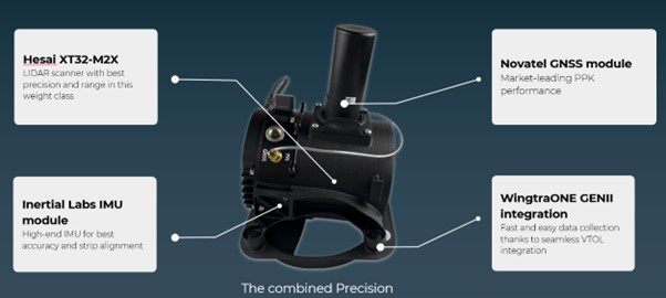
The Wingtra LIDAR sensor has 3 components: a Hesai LIDAR scanner, an inertial Labs IMU and a NovAtel GNSS.
HESAI Technology, a renowned global provider of LIDAR sensor solutions, supplies sensors utilised in various fields including ADAS, autonomous mobility, trucking robotics, AI, and numerous industrial applications. The knowledge that the WingtraOne GEN II is powered by a Hesai sensor instills a certain level of confidence and trust, customers know they are investing in reliable and high-quality product.
Navigating the workflow was straightforward for me. I initiated my flight plan using Wingtrahub, executed the data capture with Wingtra Pilot within a 4-minute flight, processed the raw data in the Wingtra LIDAR app (taking approximately 10 minutes), and finally conducted further data processing in Trimble Business Center. Within 40mins I had usable deliverables from the flight data.
The most common questions I get asked about Wingtra LIDAR and the answers!
The common inquiries I receive revolve around the flight duration, the extent of necessary editing, the processing timeframe, and the quality of data captured beneath tree cover.
The responses are 3%-5% decline in flight duration due to the weight of the camera, minimal editing is required, and the data beneath tree cover results are better than average for a 3 return LIDAR sensor.
One of the standout features of this LIDAR solution is its self-calibration capability. Unlike other units that require calibration during flight, resulting in lost flight time due to back-and-forth adjustments, the Wingtra ensures that you maximize your entire flight duration, allowing for a full flight.
You do lose some flight time because of the weight but because of the angle of coverage and overlap you can cover a wider area along the flight lines. So, transitioning between the RGB and LIDAR sensor does not impact coverage as it relates to flight time.
With a wide angle of 90 degrees, coupled with extended flight times, it can cover more ground with each pass. For instance, during a 90-meter flight, the LIDAR can cover 360 hectares while maintaining accuracies of 3cm. This represents up to a 50% increase in coverage compared to sensors of similar range.
There is no misalignment after processing with the Wingtra LIDAR so there is very little to do when processing the raw outputs.
It took me a few minutes after flight to export the raw LIDAR trajectory data, clean the runs and export the Las file for processing in our Trimble Business Centre software. The Wingtra LIDAR app enabled me to select the end and start of runs processed and export to the required coordinate system.
I do not think this is out to replace your LIDAR rotary solution as there are solutions where you will need to fly slower and require more returns to achieve that level of detail, but you lose the coverage and spend days in the field, all impacting cost, The Wingtra LIDAR solution has a strong place in the market and I was impressed by its performance.
In conclusion – my top five WingtraOne GEN II rated features
- The Wingtra’s VTOL functionality allows you to work at confined sites
- The speed and precision allow flight to cover larger areas than Rotary
- There is a wide selection of payloads for the WingtraOne GEN ll
- Wingtra LIDAR substantially reduces the need for labour-intensive post-processing strip alignment, providing precise terrain data immediately following each efficient flight.
- One of the notable advantages of Wingtra LIDAR is its ability to minimize field time, requiring no calibration and initializing in just one minute.
- The user-friendly Wingtra LIDAR app and automated experience empower users
And in a perfect world….
In all honesty the WingtraOne delivers high-quality data in demanding conditions and I’ve been extremely impressed, especially with its wind handling. Does it deliver on its promise of ‘Map Faster, Map Larger, Map Anywhere’, absolutely yes it does.
Is anything missing from the package? Not at all, the Wingtra is a premium drone and its performance, build and ease of use reflect that at every turn. However, if you really pushed me, for a wish list for future upgrades it would include live link flight mission updates or real-time viewing of data imagery, but that’s about it. Watch this space for future updates and in the meantime, for further information, please view my recent WingtraOne webinar here. or contact us for a demonstration at info@korecgroup.com
“The benefit lies in being able to record those 2 or 3 difficult points if the internet goes down that I’d otherwise need a total station for.”
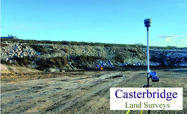
Joel Scragg, Casterbridge Land Surveys
Did you know that Trimble’s R12i, R580 and R780 GNSS all offer a feature that most surveyors never even notice, but every time it’s activated saves them up to 30 minutes in the field?
Download a PDF of the story here
Operating out of Weybridge in Dorset, Casterbridge Land Surveys Ltd is a thriving practice, experiencing a consistently high demand for its services. The company prides itself on offering cost-effective and reliable surveys backed up by a personal and personable approach.
Joel Scragg, the Director & Principal of the company, understands the challenges of managing a busy order book and the corresponding demands on both staff and his Trimble survey equipment. Consequently, he meticulously prepares for each survey, ensuring timely execution and optimal allocation of equipment resources.
With a Trimble R12i GNSS (used with a Trimble VRS license for real-time corrections) and S5 Total Station on the fleet, Joel frequently exploits this combination as an integrated surveying solution where the controller is connected to both a conventional survey instrument and a GNSS receiver at the same time to seamlessly collect points in challenging GNSS environments.
However, whilst this has proved to be an effective way of working, setting up a total station adds time to a survey …..and it’s also not always needed thanks to an often overlooked standard Trimble GNSS feature.
Positioning Insurance: Continuous corrections, even when the internet goes down
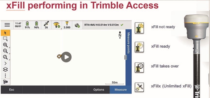
Trimble xFill is the little known standard feature that can save up to 30 minutes in the field by ensuring Joel can carry on working without disruption to his survey schedule or need for a total station set up.
It reliably provides seamless, centimetre-level back-up corrections for up to 5-10 minutes, via satellite, if RTK or VRS signal sources are interrupted due to signal disruptions or loss of radio connectivity. This provides Joel with enough time to measure points in his typical day to day scenarios such is in a quarry behind a stockpile or at the bottom of a hole.
The end result is no interruption to Joel’s survey. The only indication that xFill has been automatically activated is a small icon changing on his logger:
“The benefit lies in being able to record those 2 or 3 difficult points that I’d otherwise need a total station for. Each time I avoid having to set up the total station, I’m saving up to 30 minutes in the field. Why do most surveyors never even notice it? Because it just reliably kicks in every time it’s needed!”
What is Trimble xFill? Trimble xFill provides seamless, centimetre-level back-up corrections via satellite if RTK or VRS signal sources are interrupted due to signal disruptions or loss of radio connectivity. All three receivers supplied by KOREC, the R12i, R780 and R580, offer Trimble xFill Limited as standard. This feature is linked to the GNSS hardware, and it enables cm-levels corrections whenever the internet connection goes down, for up to 5-10 minutes, allowing surveyors to carry on working. xFill Limited is a standard and permanent functionality on the aforementioned Trimble GNSS products, included at no extra cost. Another option is to upgrade to xFill Unlimited. This feature enables the GNSS to carry on working with satellite corrections, without internet, for an unlimited amount of time. However, the user needs to be connected first to a VRS network for this to work. xFill Unlimited works on a yearly subscription. When it runs out, it will revert back to xFill Limited.
Ask us about our current special offer on xFill unlimited.
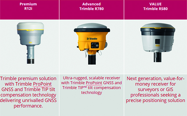
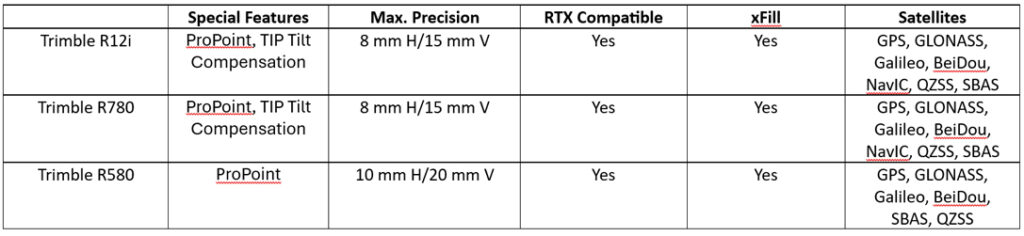
How to choose the right Trimble GNSS for your survey applications – a quick guide to our three best-selling receivers, the R12i, R780 and R580
Choosing the right Trimble GNSS receiver depends on several factors, including your specific application, accuracy requirements, environmental conditions, and budget. Here are some key considerations to help you make an informed decision:
Common factors to the R12i (Premium), R780 (Rugged) and R580 (Value)
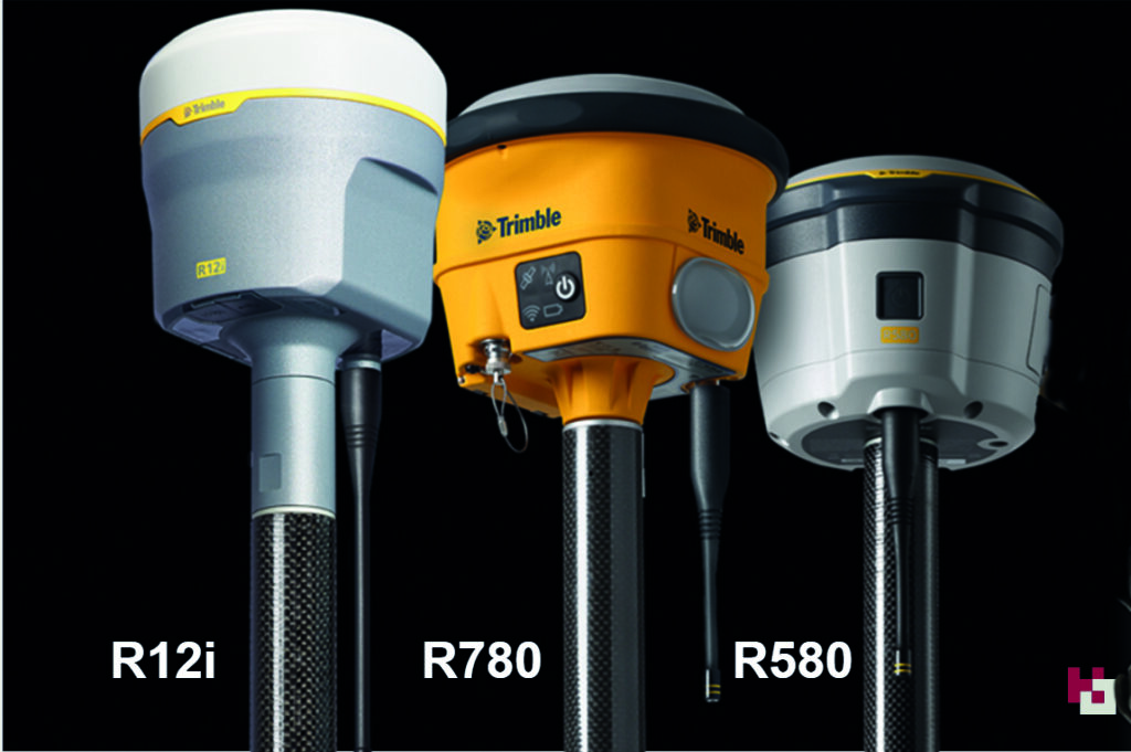
- When you buy into the Trimble brand and KOREC support, it’s immaterial which receiver you choose. All of them are based on Trimble’s 40-year heritage dedicated to reliability and innovation and they are all backed up by KOREC’s renowned technical support, training and T.R.U.S.T ethos. You’re buying into a premium brand and that brings a host of proven benefits including long term value, extensive R&D and high-level customer support .
- Trimble users have a single source of supply for the complete GNSS workflow – VRS Network, Mobile SIM cards, GNSS hardware, controllers, field software and augmentation services like xFill – just call KOREC.
- They all have Trimble ProPoint technology, Trimble’s trade-marked technology for increased performance in challenging GNSS environments, including close proximity to trees and in urban environments.
- The all have Trimble Access software compatibility and the same choice of field data loggers to run that software on.
- They all offer survey grade accuracy
- They are all compatible with Trimble Connect for easy transfer of field data back to the office and seamless integration with third party software packages such as n4CE and SCC and others.
- They are all compatible with Trimble Positioning Services like Trimble RTX, xFill, xFill unlimited and VRS Now. (See below for more details on each service)
- They all have Trimble made and supported rugged state-of-the-art field controllers in both current Windows OS and Android versions.
So what’s different?
In a nutshell:
The Trimble R12i is a premium survey GNSS offering dual Maxwell 7 Gen chip, fully loaded with all constellations, and can be used as a base and rover. Features include TiP technology (Trimble Inertial Positioning), ProPoint and xFill limited. It’s the best-in-class GNSS receiver with tilt technology and all of these features are offered as part of the standard package.
The Trimble R780 is a scalable survey GNSS offering ProPoint, a single Maxwell 7 Gen chip and is upgradeable to enable Tilt and full constellations. It can be used in base and rover modeAdditionally it has an ultra-strong housing and an increased IP spec. . This is the perfect receiver to grow with your business.
The Trimble R580 will provide the best return on investment and an affordable way to buy into the Trimble brand. It’s enabled with all constellations, ProPoint technology, and xFill Limited. However, it does not include TiP technology and is not upgradable.
FAQ’s
Which of these Trimble GNSS receiver models offer tilt compensation technology?
The Trimble R12i and Trimble R780 both offer Trimble Inertial Platform (TIP) IMU-based tilt compensation technology.
Which Trimble GNSS receiver models offer Trimble ProPoint GNSS technology?
The Trimble R12i, Trimble R780, and Trimble R580 GNSS receivers all come with Trimble ProPoint technology for increased performance in challenging GNSS environments, including close proximity to trees and in urban environments.
Which Trimble GNSS receiver models support Trimble RTX corrections?
All three models support Trimble RTX corrections, both via L-band (satellite) broadcast and over the internet.
RTX is a streaming service for corrections, managed by Trimble, which provides a correction service using a geostationary satellite – it does not require an internet connection.
On the RTX streaming service there are two products that our GNSS portfolio can use, xFill and xFill unlimited.
What is Trimble xFill limited
All three receivers offer Trimble xFill Limited as standard. This feature enables cm-levels corrections whenever the internet connection goes down for up to 5-10 minutes allowing surveyors to carry on working.
What is Trimble xFill unlimited
This feature enables the GNSS to carry on working with satellite corrections, without internet, for an unlimited amount of time. However, the user needs to be connected first to a VRS network for this to work. Ask us about our current special offer on xFill unlimited.
What is Trimble VRS Now Trimble VRS Now is a network of Continuously Operating Reference Stations (CORS), which provides users with cm-level corrections for their GNSS instruments, via the Internet. This enables users to work to cm-level anywhere there is a VRS network and a mobile internet signal. Trimble has additional permanent reference stations across the UK to strengthen the overall RTK solution, augmenting the network – increased accuracy and availability.
Q: What is the standout feature of the Trimble R12i for your company?
A: “It always works”
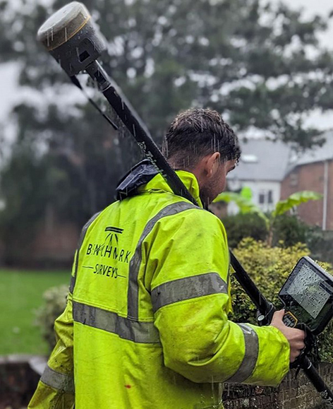
Benchmark Surveys was the first company in the UK to invest in a Trimble R12i GNSS and its continuing commitment to the technology is based on Trimble’s 40-year legacy of reliability and innovation
Download a PDF of the story here
It’s been 40 years since Trimble launched its first GPS onto the market and since then we’ve seen over 30 different iterations culminating in the arrival of the R12i in 2022.
The most advanced survey grade GNSS available, the Trimble R12i underlines Trimble’s commitment to development with its unique combination of technologies delivering a 30% productivity improvement on standard GNSS.
The adoption of this receiver by Exeter based Benchmark Surveys, the first company to purchase one in the UK, has not only transformed the way the company’s surveyors work but has also significantly enhanced the quality and quantity of data they provide to clients.
Transformative system “makes surveying pleasurable”
Benchmark Surveys’ Survey Manager, James Richards, one of xyHt’s esteemed 23 Young Geospatial Professionals to Watch in 2023, is appreciative of all the technologies offered by the Trimble R12i, but rightly points out that the single most important factor for productivity in the field is that that your GNSS always works!
He reports that everyone on the Benchmark team appreciates the R12i simply because it’s always reliable, always works and there’s never been a hardware issue – important benefits that work hand in hand with its performance:
“The R12i’s capabilities shine, even in challenging surveying environments with difficult terrains such as banks, ditches, and areas with overhanging canopies – these are scenarios that surveyors come up against regularly and an area where the R12i decidedly ups productivity. Traditional equipment might falter in such conditions, but Trimble’s TIP (insert link to piece on the IMU) and ProPoint technologies ensure that Benchmark surveyors can effectively capture these challenging data points, leading to fewer client requests for additional information.”
What was once a time-consuming task has become fast and easy and even “pleasurable”, adding to the overall satisfaction of the Benchmark team who can effectively capture points in vegetation and under canopy where other GNSS would struggle.
Instagram follower comment on post: Tilt works well under heavy canopy?
Benchmark Surveys: Yes it does 👍
In particular, James emphasises the strong business case for investing in the R12i GNSS over any other system. The decision to adopt Trimble’s technology is not merely based on brand loyalty but on the functionality and reliability that the team relies on to deliver the highest quality data to clients.
Trimble’s commitment to innovation, backed up by KOREC’s support, training and T.R.U.S.T ethos aligns seamlessly with Benchmark’s dedication to providing top-notch surveying services.
We’re delighted to announce that KOREC’s new Mapping and GIS Business Manager is one of the best-known names in the industry, and with over 30 years of experience, he most definitely lives and breathes all things geospatial!
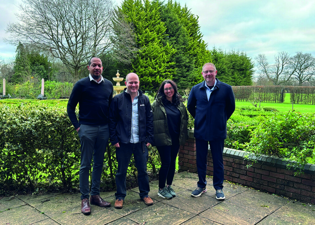
The KOREC Mapping team from left to right: Darrell Theobalds (Geospatial Technical Support – MGIS), Rob Partridge (MGIS Customer Success Manager), Nadia Oliveira (MGIS Account Manager) and John Cartledge (Mapping and GIS Business Manager).
Starting his careers with a degree in civil engineering, most people will know John Cartledge from his two decades at Ordnance Survey where he undertook a number of positions that saw him working in consultancy, commercial sales, operations, project management and development roles. He therefore has an extremely strong understanding of the unique business challenges that KOREC’s mapping customers face whether they be geospatial professionals introducing new workflows or those working in other industries with a requirement for high accuracy positioning.
Based on his 30 years within the industry, John brings with him four core beliefs, all of which align seamlessly with KOREC’s capabilities:
- Problems are there to be solved: The KOREC mapping team boasts extensive experience across diverse markets and is adept at understanding the different needs of all stakeholders involved in a project. In particular, KOREC and John have been in the mapping GPS business for the same length of time – since the beginning!
- A new workflow isn’t about wholesale change: We understand that whilst it’s all about the end data, organisations seek this result with the least disruption to their business. Just one of KOREC’s specialist areas is digitising existing workflows, another one is working with what you’ve got whether that be existing software or hardware. Compatibility is key!
- Value for money is a key customer requirement: The business case is the first step in any new project and the numbers have to add up – Trimble’s Catalyst system, a subscription GNSS with cm accuracy is one of KOREC’s most workable solutions.
- You’re never just buying a product, you’re also buying into the company’s ethos: When you work with KOREC, you can rest assured that you’re in good hands because every day, we strive to meet our five principles of TRUST; Transparent, Reliable, Understanding, Supportive and Timely. We also have a Technical Support team that’s consistently mentioned for its performance in going ‘above and beyond’
John can be contacted at john.cartledge@korecgroup.com or on +44 (0) 7870 894151
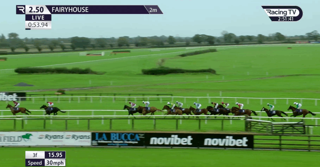
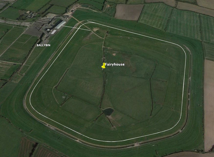
Fairyhouse Racecourse leads the way in consistent, centimetre accurate, sectional timing data with IHRB approved low-cost, ground-breaking Trimble GPS system.
Download a PDF of the story here
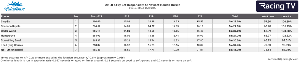
Typical on-screen information generated by Course Track from data captured by the Trimble Catalyst system
There have been longstanding concerns about the accuracy of sectional times in Irish race meetings particularly following some high-profile queries on race distances. However, Irish racing is addressing the problem and leading the way is Fairyhouse Racecourse, one of the country’s premier horse racing venues and home of the Irish Grand National.
In the world of horse racing, where comparisons related to pace, ground conditions and distance are paramount for form-study, the accuracy of furlong distance measurement is of utmost importance. Equally crucial is ensuring that the furlong measurements align with the timings displayed on television broadcasts.
Fairyhouse has proactively addressed this issue with the adoption of a centimetre accurate GPS solution that they have customised for the production of highly accurate maps of every course circuit for each of its twenty-one annual meetings. Under the guidance of Fairyhouse General Manager, Peter Roe and Track Foreman, Richard Stapleton, the course has rigorously tested, implemented, and secured approval from both the IHRB and CourseTrack (tasked with introducing sectional timing by 01/24) for its new Trimble Catalyst GPS system. The system was purchased from Trimble distributor and geospatial specialists, KOREC.
Peter Roe is especially aware of the racing industry’s increasing demand for precise data, numbers, and information for assessing a horse’s form correctly. “Unfortunately, traditional survey methods that rely on measuring wheels have proved inadequate in delivering accurate furlong measurements to the extent that we’ve had races where all seven runners appeared to break the track record. Subsequent checks revealed that the race was run over a shorter distance than initially advertised. Extensive testing by Fairyhouse of wheel measurements compared to our new survey level Trimble GPS have revealed discrepancies as high as 32m over an 8-furlong race.”
Easy to use, low cost and consistent centimetre accuracy
As the first racecourse to independently look at the technology that could assist with accurate furlong measurement for sectional timing data, both Peter and Richard were keen to implement a system that not only worked for them, but would be easily usable by other interested racecourses. Their three demands of any new system were that it was easy to use, especially for courses where staff were less technical; it had to produce reliable centimetre positions and it had to be affordable:
Achieving cm accuracy: Whilst the survey industry offers many centimetre accurate GPS systems, these tend to be designed for professional surveyors and therefore come with an extensive range of features designed for survey workflows and can cost in excess of €30,000. However, through farming contacts, Peter was aware of an alternative system, called Trimble Catalyst, that worked on an entirely different subscription-based model.
The Trimble Catalyst business model has been developed for people exactly like Peter and Richard who wish to pay only when they use the system because they require centimetre positions to supplement their primary area of work rather than all day, everyday.
The Trimble Catalyst hardware comprises a simple, low cost, lightweight Trimble DA2 GNSS receiver which offers survey-quality (cm) positioning, even in challenging GPS environments including near and among trees and buildings. The receiver is easily connected to an Android or iOS device. Fairyhouse selected a handheld Nautiz X6 ultra rugged Android phablet as being the most suitable handheld to work with their Catalyst system. The field software running on board the Nautiz X6 was KOREC’s in-house suite of customisable software, K-MATIC, including K-CAPTURE field software. The K-MATIC suite also includes the highly secure, KLEARVIEW360 cloud-based Portal for analysing, viewing and sharing the collected information.
Low cost: The cost of the Trimble Catalyst DA2 receiver part of the system has been kept at less than €500 per unit and comes with an ‘on demand’ subscription pricing model so users can select the accuracy they need, 1cm, 10cm, 30cm or 60cm. Richard opted for a 1cm accuracy subscription optioned in hourly bundles which he knew from testing, would give him sufficient time to measure the course circuit at a brisk pace to keep it within the hour.
“Ease of use has been a key concern for us in working with KOREC to create a system that’s going to be useful for other courses, some of whom would only be using it four times a year. KOREC’s customer service and technical support have been brilliant – we didn’t just buy a tool but also a team!”
Richard Stapleton, Track Foreman, Fairyhouse
Ease of use: Whilst Richard acknowledges that he is obsessed with accuracy and good with numbers he is also aware that for any system to be widely taken up it has to be easy to use and understandable with a single days training. He therefore worked closely with the KOREC development team to develop a stripped back data entry form that was based exactly on the information that the UK media company required. This included the auto recording of the race line as it was walked by Richard and the ability to stop and mark each furlong and then continue the measurement of the race line. “Ease of use has been a key concern for us in working with KOREC to create a system that’s going to be useful for other courses, some of whom would only be using it four times a year. Whilst we have customised the software, I think it can still be simplified further. The attraction of a wheel is that it requires no training whatsoever and whilst we’re never going to achieve that, our Catalyst system has been simplified with customised features specifically for furlong measurement.”
“The aim was always for Fairyhouse to be 100% accurate. Our extensive testing of wheel measurements compared to our new survey level Trimble GPS have revealed discrepancies as high as 32m over an 8-furlong race.”
Peter Roe, General Manager, Fairyhouse
Using the system
Although the Trimble Catalyst system is very light and highly portable over long distances, Richard has opted to use it in a backpack to keep his hands free for positioning furlong markers etc. In preparation for races, the rail has to be positioned as early as possible and then Richard will walk the track, measuring one metre out from the rail. The reliability of the system is key to its success particularly when races are run over three days, such as the Easter Festival, which can see him marking out six race lines. This has to be completed in plenty of time to supply the information to CourseTrack in England.
Accurate timing data is now being generated
For each circuit, Richard establishes vital reference points on the track which allow him to accurately position the start and the finish lines. Once the data is collected, it is downloaded onto the Portal for a visual check of the map and to ensure that all furlong markers and bends are correct. It is then emailed to all those who require the course information. On race days the information is used by CourseTrack to link up with trackers that each horse carried in its saddle cloth to provide accurate timing data.
“The CourseTrack system relies on accurate measurement of race distances and track layout in order to deliver sectional timing for each individual race. The team at KOREC has worked closely with Fairyhouse and other tracks in Ireland to create a bespoke product for those racecourses which the system suits, and we have high levels of confidence that the KOREC data can support accurate live and post-race data.”
Chris Murtagh, Director of Operations, CourseTrack
A visual check is always made of captured information
Future plans
While Peter emphasises the solution’s standout benefit of delivering reliable centimetre positions, he also acknowledges the vital role of KOREC’s support in the system’s successful adoption.
“Our aim was always for Fairyhouse to be 100% accurate and I think that we’ve achieved that. KOREC has been extremely loyal to Fairyhouse on this project. We invited them to come on a journey with us that may or may not work out and they’ve supported us throughout and now we’re both being rewarded. The Catalyst system is a game changer and we’ve got plans to customise it further by adding in fences and distances to create some really nice visuals for social media. It could be an amazing tool for the industry.”
Richard concludes, “KOREC’s customer service and technical support have been brilliant and I feel that we didn’t just buy a tool but also a team!”
Several other tracks have recognised the system’s value and the dedicated efforts of Peter and Richard in securing its approval, leading to further adoption across Irish courses.
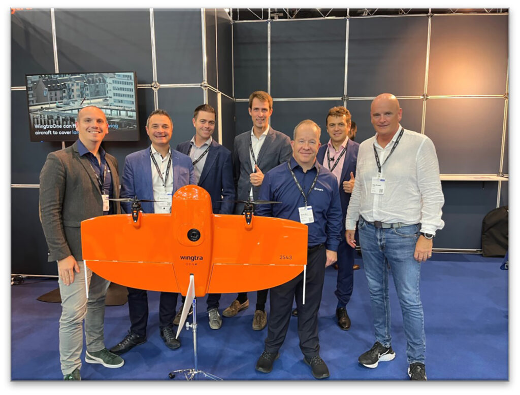
From left to right Matthieu Lefebvre, (Head Of Sales EMEA), Mark Poveda (Group Commercial Director, KOREC), Shane Murtagh, (Sales Director, Ireland, KOREC, Maximilian Boosfeld, (Wingtra Founder), Adam Box, (Regional Sales Manager UK & Benelux, Wingtra), Aleksander Kostadinov, (Global Sales Director), Alan Browne, (Group Chief Executive, KOREC)
KOREC Group is delighted to announce that it has signed an agreement to become the latest distributor to join the Swiss company’s global network of suppliers.
The agreement will see KOREC strengthening its existing fixed wing portfolio to include the WingtraOne, a premium survey drone that offers vertical take-off, PPK geo-referencing and a high-resolution payload for the consistent delivery of the high-quality data required for mapping and survey specific applications.
KOREC will build on this distributor role to establish a network of Wingtra dealers in the UK.
Mark Reid, UK Sales Director, KOREC said: “Wingtra is a world leading fixed wing mapping drone producer and its commitment to the advancement of the WingtraOne platform is truly impressive. This Wingtra ethos of continual development perfectly aligns with KOREC’s dynamic. The WingtraOne drone has already established itself as a reliable and trusted technology, making it an ideal match for our existing Trimble and K-MATIC solutions. With upcoming developments on the horizon, we look forward to working with Wingtra for a successful future.”
Adam Box, Regional Sales Manager UK, Wingtra said: “There is such a strong synergy between the technical solutions KOREC provides and the Wingtra solution that we couldn’t be happier with this new partnership and the opportunities that it will generate. The future looks bright and exciting and I cannot wait to help them paint the sky orange.”
KOREC will offer a full WingtraOne distributor service including sales, training and support throughout the UK and Ireland.
ENDS
Download a PDF of the press release here
How BB Surveys successfully completed a vast football stadium project with over 4,600 scans and and multi-sensor integration to create a range of high-quality deliverables.
Download a formatted verion of the case study here
Based in the East of England and operating throughout the UK, BB Surveys is an experienced and trusted land surveying company that undertakes a range of surveys including topographical, as-built, 3D Laser Scanning and high precision monitoring.
The survey team, under the leadership of Owner Barry Burrows, may be compact in size, but this understates the company’s commitment to cutting-edge surveying techniques and advanced computer technology. Not only was BB Surveys the first practice in the UK to acquire a Trimble X7 3D Laser Scanner, the company also has the advantage of retaining the most experienced user of Trimble RealWorks software in the UK and Ireland in Scanning Specialist Jason Jones.
Trimble RealWorks is point cloud processing and analysis software for 3D laser scanning professionals. It includes automated tools and point cloud specific workflows allowing users to import point cloud data from virtually any source, then quickly process, analyse and create the high quality customer deliverables that BB Surveys is known for.
Solely responsible for processing all laser scanning jobs and experienced in using a range of different laser scanners since 2010, Jason switched to Trimble RealWorks over a decade ago and today RealWorks and Trimble Business Center (TBC, for transformation of field data into high-quality client deliverables) remain his go to software for processing scan data.
A vast project and finding the right solution
The main use of the Trimble X7 for BB Surveys is for measured building surveys, both internally and externally. These can range in size from a single barn or residential building to more recently, an entire football stadium. The team has an extensive KOREC supplied Trimble portfolio at its disposal and therefore can pick the best solutions specific to each project choosing from high accuracy total stations, four types of GNSS, including the R12i, the X7 3D Laser Scanner and also a Trimble SX10 Scanning Total Station.
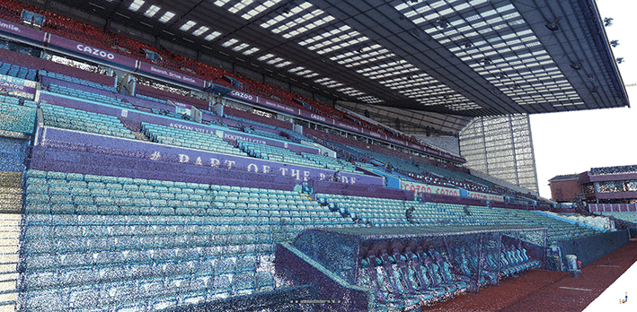
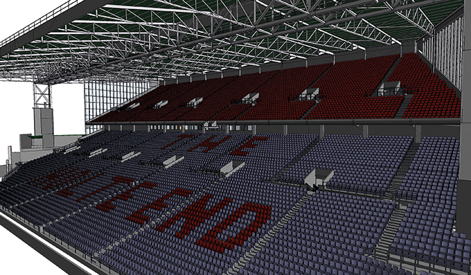
BB Surveys was recently commissioned by Foxton Construction to carry out a laser scanning project at Aston Villa F.C. and in particular to update information on the Holte End to assist in the planning and design of new seating proposals. The job would require both internal and external scans with a deliverable of 2D elevations, 2D floor plans and 3D Revit model.
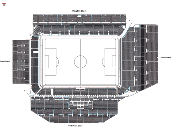
The job then expanded to include a scan of the externals of the entire stadium as well as full internals of 3 of the 4 stands and the entire bowl seating areas. Further deliverables included 12 external elevations across all 4 stands, 4 pitch-side elevations, a full seating plan of all 42,000+ seats, 16 floor plans, a 3D model of the Holte Stand, internals and externals, and multiple sections through the stadium’s hospitality suites.
Combining data from 4,600+ scans and multiple sensors
Jason Jones knew that a job of this scale demanded the use of a range of survey methods and sensors. However, as an experienced TBC user, he also knew that, if the data capture was handled correctly, it would be a relatively straight forward process to combine all the collected data into a single software package, in this case TBC, to help streamline and speed up the processing.
On site, a range of sensors were therefore used:
Trimble SX10 Scanning Total Station: The BB Surveys team traversed in ground control using the SX10, carrying out some laser scans as they worked. These scans, once processed, formed the primary control for the Trimble X7 scans to be registered to.
Trimble X7 3D Laser Scanner: The team supplemented their existing X7 with an additional one hired from KOREC to handle the high volume of work. Scans were undertaken internally and externally. For a project this size, Jason felt that Perspective software for in-field scanner control and registration was key to the success of the work. The surveyors on site were able to split the scans into multiple registration sets on the controller. This not only kept the enormous amount of scans organised for the on site scan team , but also these registration sets transferred over to RealWorks as Groups helping to speed up the registration/refining process. Being able to rename registration sets in the Perspective software was of significant help once the data was in RealWorks.
Trimble R12 GNSS: a Trimble R12 was used to survey the ground control and this allowed the team to accurately place the project onto the OS Grid although this was kept at a scale factor of 1.
Rotary drone: additionally, the team captured aerial imagery of the roof which was then fixed to the ground control and the point cloud was then brought into Trimble RealWorks to be combined with the point cloud from the terrestrial scanners.
In total, BB Surveys carried out 4,647 scans with the Trimble X7 plus additional scans with the SX10, generating over 24, billion points and more than 1,000 GB of data across four RealWorks projects.
Handling the data
Back at the office, the SX10 and R12 data was imported into TBC to process the traverse and then the point clouds were exported into Trimble RealWorks. All data from the X7 was imported directly into Trimble RealWorks before being exported for drawing/modelling.
Trimble RealWorks was used to process and combine all the laser scans. Once in the software, the data was split down into four separate projects, one for the externals and pitch side scans, and another for the internals of each of the three stands scanned. This helped keep the file sizes smaller and consequently, more manageable.
RealWorks has the ability to export the registration to the RAW scan files. This allowed Jason to bring individual scans into multiple projects to ensure continuity between projects without needing to export point clouds or re-register scans.
RealWorks is also able to show multiple projects at the same time and this helped him to monitor the quality of the registration between projects throughout the processing of the data, without needing to combine all the scans into a single project.
Reflecting on the highly successful completion of this job, Jason has no hesitation in attributing a significant portion of its timely accomplishment to the combination of the Trimble X7 Laser Scanner and Perspective software, notably its on-site registration capabilities. “Before we had the ability to register scans as we went along, even a job involving just fifty scans across one or two levels could become quite cumbersome, necessitating site diagrams illustrating scan positions and inter-level connections. Imagine the complexity of a project like this one, with literally thousands of scans. The X7, Perspective software, and RealWorks have proved to be an invaluable combination.”
Top 4 RealWorks takeaways from Jason Jones on this project:
- For especially large projects, when you are importing your TDX files into RealWorks, choose a larger Spatial Sampling distance (20mm). This should still be enough to register the data together but won’t slow the process down with too many points. Then once registered, you can bring in more points for drawing/modelling/exporting using the Create Sampled Scans tool or Limit Box Extraction. Also applying a maximum distance on the data loaded will help reduce the number of points.
- Rather than using checker boards or other targets for georeferencing, we used SX10 scans coordinated using site control. This way we had millions of points to fix to, rather than just a handful of control points.
- Split your project up into groups for registration and in particular for refining the registration. These could be entire floors of a small building or a group for each room/corridor/stairwell if you are dealing with much larger spaces. Registering and then refining each of these groups in turn and then registering these groups together keeps the data sizes down for each process on larger projects and helps speeds up the processing. These groups and subgroups can then be merged once the registration has been finalised.
- Keep your RealWorks Project saved on your root drive whilst registering and not buried in a series of multiple sub folders with long names as this can cause the software to crash or run slowly (eg. D:\Wall Scan.rwp rather than D:\Workarea Laser Scanning\Project 0001 – Client – Building Project\Wall Monitoring\RealWorks\Wall Scan.rwp)
Top benefits of the Trimble X7 for BB Surveys
On-board registration with the Perspective software – this saves hours of processing time and makes it easier for companies like BB Surveys where they have different teams for data capture and processing. Plus, you can see your fully registered point cloud before you leave the site avoiding any gaps through missing scans.
On-board calibration – both the time and monitory saving of this is huge. With BB Survey’s previous scanner, the calibration cost was around £4k and could leave them without a scanner for several weeks at a time.
TDX file format – the X7 data works smoothly with all of BB Survey’s software packages allowing the team to switch easily between TBC and RealWorks and for combining data from the X7 and SX10 seamlessly.
The X7’s indoor mode – a useful way for speeding up internal scans, saving 10 seconds each time, which adds up on a project of this scale.
KOREC support – BB Surveys states that over the years KOREC has been a great source of advice, technical support and training.