Many thanks to the KOREC customers who joined us for the three days and have kindly shared their highlights.
Trimble’s in-development SiteVision certainly caused a stir as did the HoloLens solution and the just released v5 of Trimble Business Center.
With 4800 registered attendees from over 95 countries, Trimble’s Las Vegas Dimensions event is huge!
Steve Jones, Commercial Manager, Severn Partnership
“Dimensions brings together Trimble professionals and instrument users from all over the world and having the chance to talk to them, along with KOREC experts, was invaluable. Many of us face the same commercial challenges, irrespective of where we work, and there are solutions out there – this was the perfect forum to learn about them. I’m particularly interested in how we can take Trimble’s innovative technology and use it, not to replace what we already have, but to discover new applications that will add value for our clients, improve workflows and help business grow. We’re always asking how we can do things better and Dimensions has provided plenty of exciting ideas. The Trimble SX10 is a great example of this and the presentation based on a job in Alaska really showed off its scan speed and the high quality of the point cloud generated, even in the toughest conditions.
Other developments, such as the streamlining of workflows, handling of multiple data sets in a single environment (TBC v.5) and of course seeing how technology can be used away from a laptop/office environment via apps such as the monitoring app, or through the adoption of Trimble’s Catalyst solution, were also thought provoking. Using Trimble Catalyst, it would be relatively straightforward for us to create our own apps that could, for example, augment our asset/utility data collection and that is particularly exciting.
Overall, Dimensions was a fantastic experience and not a single minute of it was wasted time thanks to KOREC and Trimble’s hard work!”
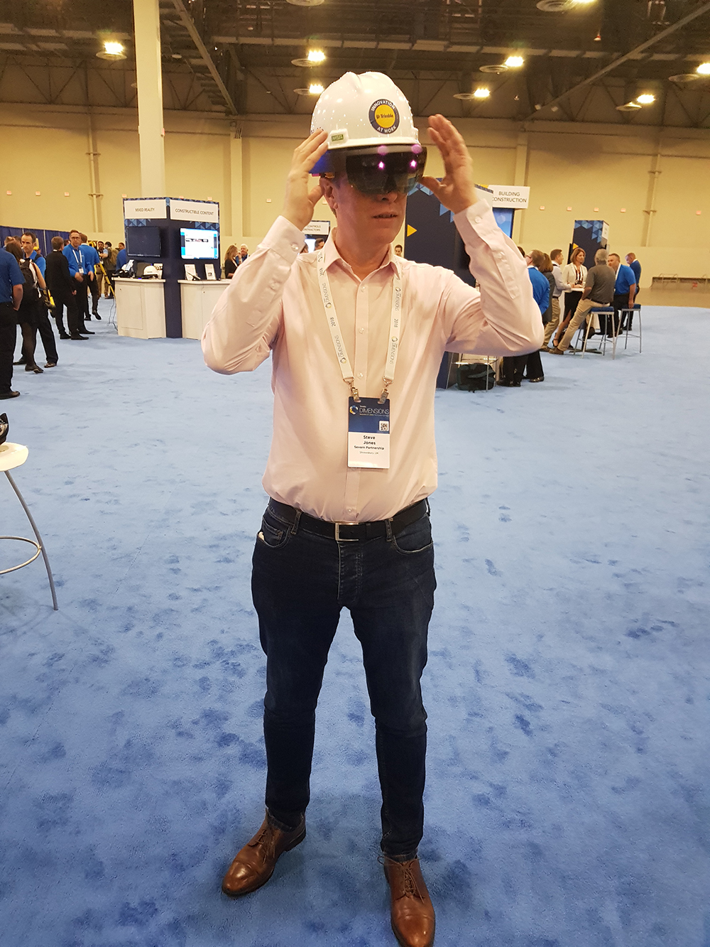
The badge says it’s definitely Steve Jones under the HoloLens!
Mark Lawton, Chief Engineering Surveyor, Skanska
“The sessions on Trimble Business Center were particularly educational, especially now that it is merged with the Heavy and Highways edition which means just one platform and one software for our IT to support. Whilst there is a strong focus on 3D, TBC still has lots of useful 2D functionality that remains relevant, especially for quantity surveyors, for example, take-off.
HoloLens and the mixed reality world is another interesting area. I was lucky enough to come away with a mixed reality unit and will be investigating the applications that are most appropriate to both Skanska and the industry as a whole. We also got a sneak preview of a new product with ‘yes’ ‘no’ brain wave reading capacity.
However, the stand out benefit was having all Trimble’s experts and developers in one place for a session where I could pitch and share ideas with the decision makers.”
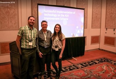
Mark presented at Dimensions: “The successful implantation of technology on the A14 improvement scheme” Pictured here with KOREC’s Jared Pogmore (left) and Elly Ball (right)
Paul Henzell, Director, Three 60 Mapping Ltd
“Dimensions was a great opportunity to find out more about mixed and augmented reality and I’ll definitely be looking at SiteVision when it comes live in 2019. It’s a high accuracy mixed reality system that uses a Trimble Catalyst receiver to link design models and current site conditions. For me it’s is an obvious choice for a move into this type of technology and something I can see myself integrating into my projects.
It was also interesting to see the autonomous vehicles off site. Las Vegas clearly showed how forward looking Trimble is making Dimensions a very worthwhile event.”
Paul’s SX10 photo was used in a keynote presentation by Trimble Senior VP, Bryn Fosburgh
Neil Jefferies, Director, Greenhatch Group Ltd
“My sights were primarily set on increasing the productivity of our SX10 Scanning Total Station. Its flexibility is second to none and we have been able to tackle a vast number of projects with one single instrument in a world where the geospatial surveyor’s tool bag (or wish list!) is getting bigger and bigger. The SX10 can tackle a multitude of tasks in one convenient package thus negating the need for a variety of equipment.
The Dimensions sessions were informative, interesting, numerous and varied and provided a very detailed insight into the many capabilities of the Trimble solutions, with the majority of talks provided by people who use the products day in day out.”
Wayne Nolan, Senior Site Engineer, Felix O’Hare & Co Ltd
“It was great to see how other construction contractors are implementing digital construction; from the design process, the procurement of materials and the construction activities on the site. It really does show how far advanced some countries are in relation to BIM and digital construction relative the UK and Ireland!
Virtual Design Construction (VDC) is key for many contractors in the States where they plan the work and work the plan through VDC processes between key stakeholders, within the office and of course in the field. One area in particular which I would love to see implemented more in our construction industry is the 3D modelling of steel reinforcement/rebar and the formwork elements – as used during the construction of the Museum of the Future in Dubai by BAM International. This really does highlight construction innovation in practice – to see how far the industry has come over the past few years is truly amazing!
In particular, it was great to see how other construction companies are using field technology such as Trimble FieldLink to carry out their day to day layout activities to ensure efficient workflows are maintained in both the office and in the field. Being able to compare my own workflows on site to others proved invaluable. I was able to take away some great knowledge, tips and tricks to make my daily layout and validation techniques more effective and efficient on site.
The conference proved that Trimble really are market leaders with the digital transformation within today’s construction industry with the future of construction being – Connected, Content-Enabled and Constructible within the various areas of Architecture, Civils, Structures and MEP. The services they offer and the software solutions available to the industry are second to none whilst always striving for improvement and innovative ideas to ensure client demands are met!
Being able to see the new Trimble Business Centre V5 software that’s just been released gave a good insight into how workflows are being integrated and results are maximised – as a construction company this is something we see as a valuable tool within our construction processes to ensure we have the most modern software technologies available to provide the best possible data.
However, it was the Trimble HoloLens and the Trimble SiteVision that really stood out for me! Being able to utilise mixed reality for project co-ordination really will be a game changer for Trimble by providing precise holographic models and data in the real world. Being able to show stakeholders and clients the finished product by just wearing an advanced hard hat whilst standing in a green field site before the project has even commenced is truly amazing and speaks volumes for Trimble’s commitment to digital construction and innovation! It’s like seeing into the future – an impressive piece of kit which I hope to have the guys from KOREC on site for a demo in the near future.
Seeing Trimble SiteVision at the off-site Expo really impressed…it’s a relatively cost effective solution with cm accuracy using Trimble Catalyst and a mobile device or tablet – to be able to stand a see utilities and services in the ground along with drainage lines and manholes will really be fascinating for the construction industry in the UK and Ireland! This will revolutionise the industry in the coming months and years ahead whilst showing how the construction will fit into the existing environment and how services can be seen below your feet without having to put a digger bucket in the ground! Not only will this benefit the industry but it will also enhance the safety of the industry dramatically for machine operatives as it will be a valuable tool in preventing damage to services within the ground etc. and they will be seen before work commences! An amazing piece of kit!
All in all, the conference from start to finish the conference was excellent and an experience I will never forget. The hospitality shown by the guys from KOREC and Trimble was second to none – I cannot thank you guys enough for the opportunity to attend such an event. It really was a privilege to be a part of it as a guest with KOREC. Great time had with good people – making new contacts proved invaluable to me for the future!

Wayne Nolan (far right) with KOREC’s Fran Mullally (left) and Shane Murtagh (middle)
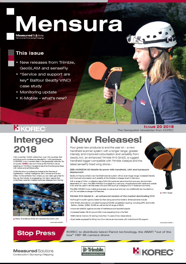
It’s the final issue of Mensura for 2018 which means we’ve featured some great new releases from Intergeo and also a case study that’s a bit different. This one looks at why service and support are vital elements in any purchasing decision concerning technical equipment.
Issue 20 covers:
- New releases from Trimble, GeoSLAM and senseFly
- “Service and support are key” Balfour Beatty VINCI case study
- Monitoring update
- K-Mobile – what’s new?
Email us at marketing@korecgroup.com if you’d like to receive a copy of future issues by post, otherwise download issue 20 here.
For over a year now, our Trimble monitoring system in Huntingdon has been running faultlessly using the Settop M1 communications hub connected to a Trimble Autolock Total Station.
With this setup, the data is transmitted via SIM to a PC running Trimble’s T4D monitoring software which publishes the data to a web portal. The engineer can then log-in and manage projects from anywhere, and even view the site live through an easy to configure webcam service like the one we have just installed on our KOREC demonstration system.
The M1 up and running in Huntingdon so we took the opportunity to have a QA session on this topic with the Monitoring Solutions Trimble Regional Sales Manager EMEA, Alberto Bushell:
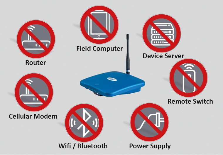
What does the M1 setup entail?
AB: The Settop M1 Monitoring Controller is an all-in-one device. Next to incorporated communication options like cellular modem, Wifi and Bluetooth, it is a router, a remote switch and a device server at the same time. Only one central power supply is required and all cable connections between different hardware devices become obsolete. It also includes the auto-start functionality that requires a specific cable between device server and total station if no Settop M1 is used. Reduced cables and hardware together with the nice web interface of the Settop M1 ensure an easy set up.
Aside from a simplified setup, what other benefits does the M1 bring?
AB: It can control the total station and ensures rounds are measured even in case there is a temporary drop in communication to Trimble 4D Control. Due to its large onboard memory it is able to buffer round information during communications outages. It works seamlessly with Trimble 4D Control software and guarantees full data integrity. The communication to Trimble 4D Control software can be established via a secured cloud service connection (IST Connect). This is especially beneficial if there is no static IP address for the Settop M1 available.
What would be the two main system priorities for the monitoring end user and how can the M1 contribute to these needs?
AB: Reliability: Monitoring operations require reliable solutions, the M1 ensures 24/7 operations during years and, in case of network failure, it can store data for weeks for later use in T4D.
Ease of installation: This plug&play solution offers an advantage on difficult installation environments and shorter intervention periods in areas with dense traffic.
Trimble offers many monitoring systems but what would you recommend for a good all round remote, real-time system?
AB: This really depends on the project, and what the customer needs. A real-time monitoring system would usually include Trimble 4D Control (T4D) realtime monitoring software which can take data from a range of Trimble Total Stations, GNSS receivers and geotechnical sensors like crack gauges and tilt sensors from a number of different manufacturers. The data from total stations can be received via radio (ideal on some compact construction sites where radio comms work well) or Settop M1 total station controller (if the instrument is too far away from the PC running T4D to use radios). If its remote, I would suggest a Settop M1 controlling a Trimble S7, S9 or the new S5Ti-M running alongside T4D. If additional sensors are required, we can scale the solution to suit.
If you could have three words to describe the M1, what would they be?
Comprehensive, robust and powerful!
To find out more about how easy and cost-effective it is to benefit from Trimble monitoring solutions, please do get in touch with KOREC monitoring specialist, Matthew.lock@korecgroup.com
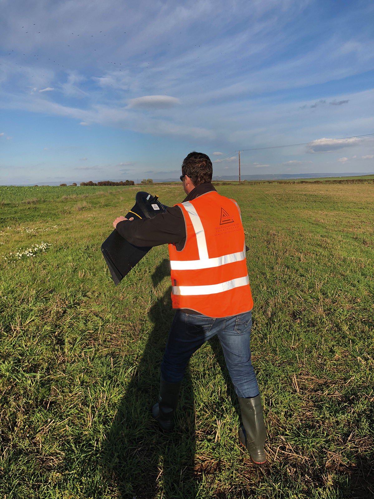
Ted Harland launching his new senseFly eBee X
senseFly’s newly launched eBee X has provided exactly the functionality that Ted Harland, Managing Director of Yorkshire based Tri-Tech Ltd, requires for demanding quarry surveys and aerial mapping projects.
For Ted Harland, it’s always been about choosing the best instrument for the job and Tri-Tech surveys has invested in a surveying fleet that makes that entirely possible by including cutting edge technologies such as Trimble’s R10 GNSS and SX10 technology for ground-based work and rotary drones for aerial projects.
Although satisfied with the performance of the rotary surveying drones, Ted was keen to find a solution that would be better equipped for his primary areas of aerial work, namely larger scale mapping projects and quarry surveys where conditions can be particularly windy with landing space at a premium.
The recently launched fixed wing eBee X has proved to be the perfect solution offering new technology that includes a more rugged build, the introduction of built-in space-friendly Steep Landing technology (35° approach) and a range of camera options for customised applications. Ted opted for the S.O.D.A. 3D for the best results on vertical faces/buildings and the Aeria X RGB photogrammetry camera for day to day mapping projects.
However, for Ted, the practicalities of delivering quality, timely data to his clients dictate his investment decisions and he stresses that the senseFly eBee X is a fully intergrated ‘off the shelf’ product fully supported by KOREC and that these factors played a large part in his decision.
Our new Irish newsletter is out now. Dedicated to all things geospatial in Ireland and Northern Ireland, our first issue looks at new releases from Trimble and senseFly, a case study from Felix O’Hare outlining their use of Trimble FieldLink and of course all the latest news from KOREC
The full issue can be read here.
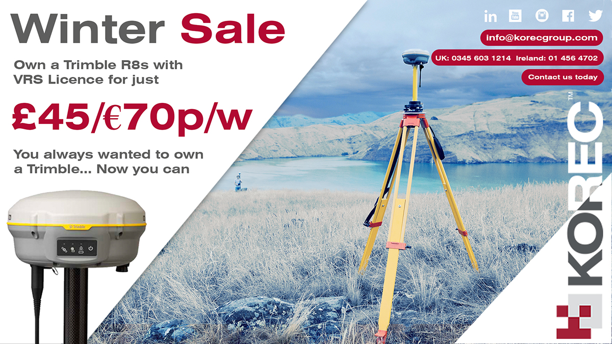
Fred Astaire and Ginger Rogers, Tom and Jerry, Thelma and Louise…we love a good double act, especially when they really complement each other, and that’s why we’ve introduced this Trimble R8 and VRS Now offer!
On the one hand we have the R8, Trimble’s flexible and scaleable GNSS that allows you to choose the configuration level that suits you best – post-processing, base, rover, or a combination of base and rover functionality. After you’ve selected your configuration, additional options can be added as your business grows!
Find all the Trimble R8 facts and figures here
And on the other hand, Trimble VRS Now, a real-time correction service that has been described as ‘unbelievably reliable’ by KOREC customers more times than we’ve had hot dinners. So much so that it’s the chosen service for Highways England for use by the police, primarily for collision scene investigation. And did we mention that KOREC customers have switched their GNSS fleet to Trimble just to get their hands on this winning combination?
Here are a few of our VRS Now case studies:
Highways England renews Trimble VRS Now license with KOREC
Why Greenhatch switched to VRS Now
Team SUMO chooses a perfect combination in the R8 and VRS Now!
Skanska’s Trimble VRS now journey – 7 years on
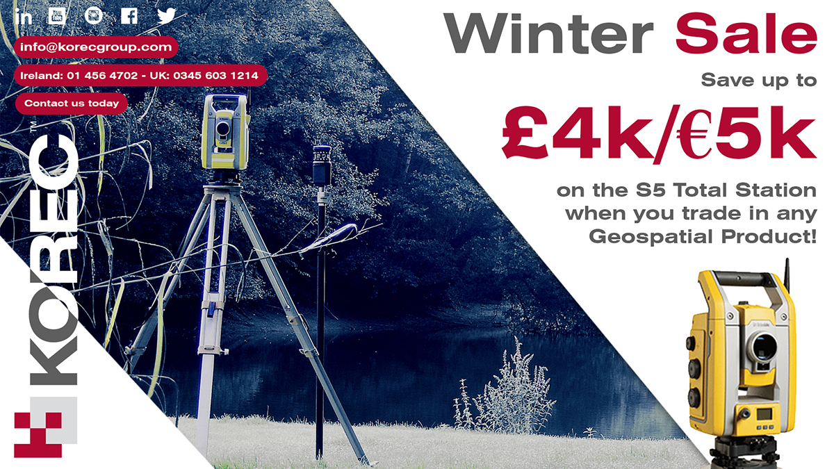
It’s been really hard to find the perfect way to describe the Trimble S5 Robotic Total Station for this special winter offer.
First of all, we came up with ‘entry-level’ but the only thing entry level about the S5 is its price because it has the same chassis and build as the advanced Trimble S7 Series and can be paired with Trimble Access software for the same workflows and advanced capabilities as any other instrument on the fleet. It also offers the same market leading Trimble technologies:
Trimble MagDrive: Smooth and silent, electro-magnetic technology means fewer moving parts. The instrument moves faster whilst under lock which allows for greater freedom of movement whilst tracking a prism This also reduces wear and tear extending the life of the instrument.
Trimble SurePoint: Ensures accurate pointing and measurements by actively correcting for unwanted movements like wind, handling and sinkage.
Active and Passive Tracking: No need to educate the S Series on what not to track – it will only track the ID requested on the active tracking system. It will also track passively for auto centering on traverse targets or when using your favourite mini prism for accurate setting out.
L2P – Locate to Protect: Pure peace of mind. Know where your instrument is at all times and receive alerts when it leaves a defined area. You can also be alerted when your instrument is knocked, letting you know it would be prudent to put it on a base line for checking.
Compatible with two active targets: For the topo surveyor there is still no beating the MT1000 – renowned for the solid lock through vegetation, even when you cannot see the prism. For the setting out engineer we have the AT360 – total confidence in the accuracy of your work with the electronic bubble from the AT360 prism which allows you to see on the controller exactly how accurately you are measuring for setting out. No need to rely on the basic bubble from the pole.
But back to the story….Then we came up with ‘robust’ and ‘workhorse’ because an all-rounder like the S5 sees plenty of site use and understandably a few hard knocks as well.
Finally, we came up with ‘Packs a Punch’! To find out why, read our case studies below and check out its spec. here

John Sisk & Son choose the Trimble S5 and Trimble ActiveTrack technology for busy Dublin site
Murphy Surveys Ltd – The S5’s L2P tracking technology ensures a safe return

Here’s our fact file on the Trimble R10 – everything you need to know on why this is a winter offer that shouldn’t be missed!
Since its launch in 2012 the R10 has proved to be one of KOREC’s best selling products. It’s generated more KOREC case studies than any other Trimble instrument and provided us with a CES magazine front cover photograph that became recognisable across the world. Remember this one?

But what do KOREC customers value most about their Trimble R10’s performance? First up, there are honourable mentions for all the R10’s patented technologies including:
- Trimble CenterPoint RTX delivering GNSS corrections via satellite or internet connection with unprecedented speed and accuracy for a PPP solution
• Trimble xFill ensuring less downtime in the field, with continuous RTK coverage during connection outages from an RTK base station or VRS network
• Trimble SurePoint fully compensating for pole tilt for the convenient measurement of points that were otherwise inaccessible with complete quality assurance
But coming in at number 1 in our R10 customers’ most valued feature list is the R10’s cutting edge Trimble HD-GNSS processing engine which simply enables surveyors to measure points more quickly!
Here’s why the R10’s HD-GNSS processing engine makes it the industry’s turn to GNSS solution:
Trimble has a strong history of in-house is development which is why we have HD-GNSS, the ‘quiet’ hero of the R10. In keeping with Trimble’s ability to produce systems aimed specifically at the needs of the land surveyor, the HD-GNSS processing engine of the R10 provides markedly reduced convergence times as well as high position and precision reliability when compared to earlier processing engines, especially in poor GNSS environments. Key benefits Trimble HD-GNSS delivers include:
- Increased initialisation speed
• Improved real-time measurement precision
• Elimination of the possibilities of a “bad fix”
• Increased reliability of precision reporting
• Reduced post processing complexity for the user
The R10 is based around the Trimble Maxwell-6 custom integrated circuit technology for GNSS signal processing RTK calculations are performed in the R10 with a microprocessor that has more magnitude and is more powerful than anything before it and also more energy efficient. The shift to this new methodology makes it possible for Trimble to continue to improve performance as GNSS constellations develop. Fully scaleable through firmware and software updates, HD-GNSS is well positioned to take full advantage of additional GNSS satellites and signals to further improve surveying in increasingly demanding field conditions.All this is possible because, unlike most other providers of survey grade GNSS, development is in-house and fully under Trimble’s control allowing the company to meet a very specific set of requirements, namely those of the surveyor in the field. Download the Trimble HD-GNSS white paper for full details or call your regional KOREC survey consultant for a demo.
KOREC customer R10 case studies
Greenhatch Group switches to Trimble R10’s and VRS Now for reliability
Land and Satellite Surveys – catching up with the first KOREC customer to purchase an R10.
Skanska – the Trimble R10 delivers on M1 J19 improvements.
Costain – M6 and M1 road projects
Academy Geomatics – Coastal monitoring with the R10
……and of course to check out all related R10 features, datasheets and videos, visit here.
KOREC is delighted to announce that under the terms of a new agreement with 3D mobile mapping technology specialists GeoSLAM, it has become an official distributor of the company’s ZEB-REVO handheld laser scanning solutions in Ireland. KOREC already successfully distributes this product throughout the United Kingdom and Northern Ireland.
GeoSLAM specialises in the manufacture and development of “go anywhere” 3D mobile mapping technology, a range which includes its ZEB-REVO handheld, lightweight scanner, ZEB-CAM camera, and the recently launched ZEB-REVO RT (real time) scanner. With no requirement for GPS, GeoSLAM technology allows users to rapidly build a highly accurate 3D models within minutes, whilst on the move. It is adaptable to any environment including complex and enclosed spaces, and especially GPS-deprived spaces – such as indoors or underground.
Once mapped, the synchronised ZEB-CAM imagery and ZEB-REVO point cloud data can be viewed in GeoSLAM Hub software – in both 2D and 3D formats. For larger projects, multiple datasets can also be merged. Results are available in all major industry standard formats and users can select from a variety of export options and configurations to enable greater integration with 3rd party post processing software.
KOREC will be supplying the ZEB-REVO system which includes the handheld scanner, data logger and desktop pointcloud processing software, all backed up by KOREC’s world class support and training.
Mark Poveda, KOREC Group Commercial Director said,
“KOREC is extremely excited to be partnering with GeoSLAM to supply the ZEB REVO system. With the ZEB-REVO scanner you can very rapidly map a huge array of environments to an accuracy level of ±15mm. The ZEB REVO fits perfectly into KOREC’s product portfolio, offering our Irish customers enhanced scanning capabilities on projects ranging from measured building surveys, construction, stockpiles, crime scenes and beyond.”
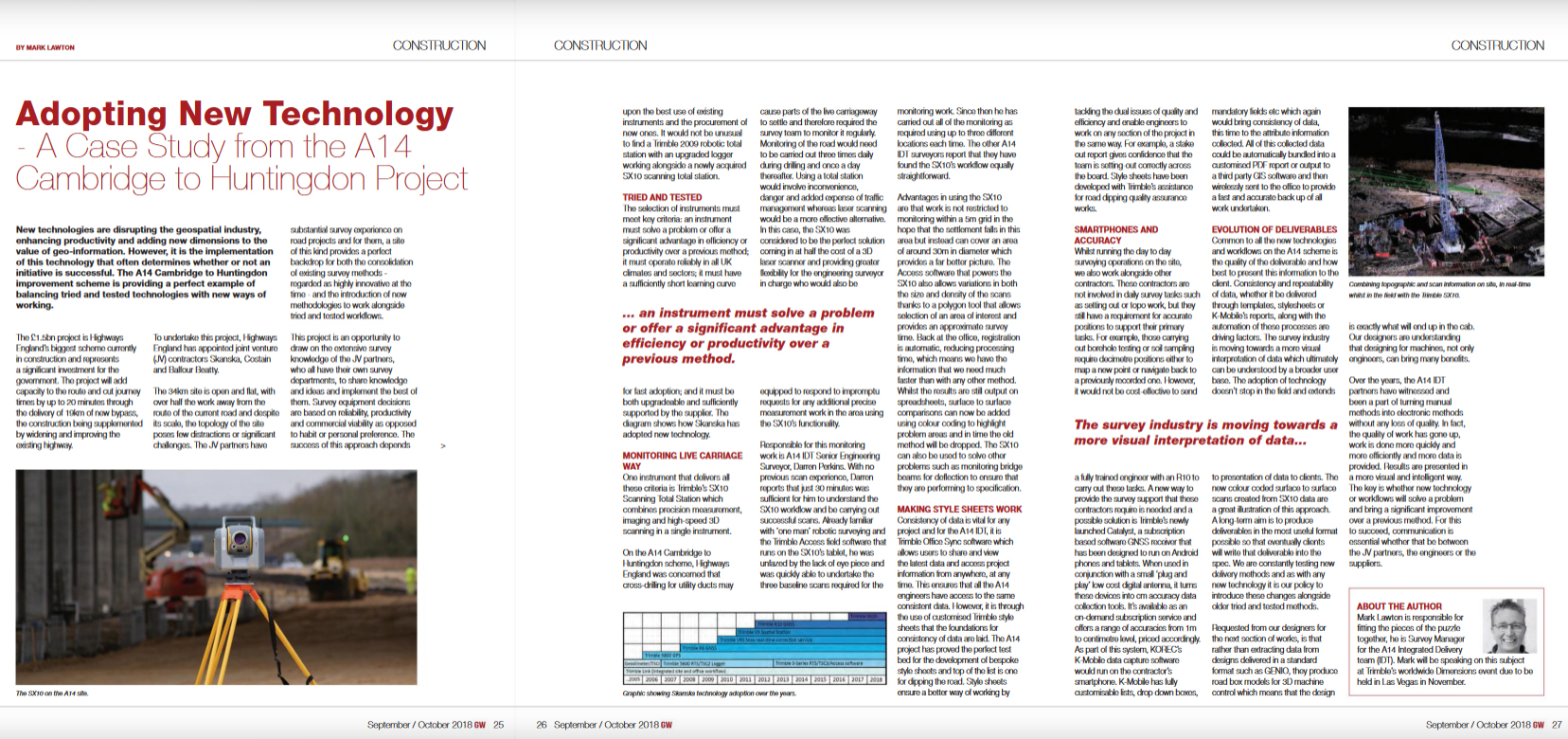
Our thanks to Mark Lawton, Survey Manager for the A14 Integrated Delivery Team (IDT), for his article published in the September/October issue of Geomatics World. Mark is responsible for fitting together all the pieces of the survey puzzle and in this piece explains the team’s approach to the adoption and integration of new technology.
Mark will be speaking on this subject at Trimble’s Dimensions event in Las Vegas in November.