KOREC Group is delighted to announce the consolidation of its relationship with sales, hire and service providers, SEP Geospatial. Under the terms of a new agreement, which is effective immediately, SEP Geospatial will become a KOREC reseller for Trimble Geospatial in the UK.
The new agreement entitles SEP Geospatial to resell Trimble Geospatial products into the construction sector. Through this agreement, KOREC, as the authorised Trimble dealer in the UK and Ireland, will seek to strengthen its presence in the onsite construction market.
The KOREC agreement puts in place a structure to accommodate the growing demand for Trimble technology within the UK and to enable a greater Trimble presence within new markets whilst ensuring that the high level of expertise and service experienced by existing customers is continued into new areas.
Trimble customers working in the construction sector will additionally benefit from SEP Geospatial’s 30 years of industry experience, Trimble product knowledge and its in-house support and hire services.
Alan Browne, CEO, KOREC said: “The demand for Trimble Geospatial solutions in the UK is at an all-time high with increasing popularity in the Geospatial and Construction sector. Through this agreement with SEP we strengthen our continued partnership to deliver market leading Trimble solutions and services to the UK construction market.”
Oliver Brooks, Managing Director, SEP Geospatial said: “We are excited to support the growing adoption of Trimble in the UK and this new partnership with KOREC enables us to support our customers with the best-in-class products they need backed up by our technical support and service operations.”
ENDS
About KOREC Group
KOREC Group specialises in the provision of intuitive software and world lead positioning technology for the measurement, mapping and management of the natural and built environment.
KOREC is the UK and Irish distributor for Trimble (www.trimble.com) and operates nationwide out of offices in Huntingdon, Liverpool, Dublin and Craigavon (NI).
About SEP Geospatial
SEP (Site Engineering Personnel) Ltd, has over 30 years of experience within the onsite construction market and provides a full one stop shop through its industry experts.
SEP Ltd operated through three distinct divisions: SEP Engineers, SEP Geospatial and SEP Technical.
www.sepltd.com
Download a PDF of the release here
MORE, MORE, MORE!
KOREC Rail announces plans for Rail Live – Stand F25
The KOREC Rail theme for this years’ Rail Live event is ‘MORE, MORE, MORE! Here’s why:
More rail related solutions
KOREC Rail is renowned for delivering Trimble technology for track survey and measurement, but did you know that we also offer rail related mapping, forensics, monitoring, 3D Laser Scanning and mobile mapping solutions?

More people for you to talk to
On our stand we’ll have all the KOREC Rail team plus consultants from our monitoring and mapping business as well as Trimble Rail’s Matthew Moss.
More equipment on the stand for demonstrations
On the stand, we’ll be featuring two Trimble GEDO systems, Trimble’s MX50 Mobile Mapping System, a Trimble X7 3D Laser Scanner, a Trimble S9 high accuracy Total Station and a Trimble SX12 Scanning Total Station. We’ll also have a ‘tunnel’ and rail setup.
More giveaways
KOREC is s a proud member of the SME Climate Hub, and we have publicly committed to halving our carbon emissions (2021 baseline) by 2030 what better way to reflect this than with our Rail Live KOREC giveaways, individual mini desk top gardens & seed bombs!…and if it’s sunny, we’ll also have KOREC branded sun cream.
More
….and just when you thought we couldn’t offer anything else, don’t forget to tag @KORECrail on our LinkedIn page to win £300 worth of Greggs vouchers.
We look forward to welcoming you on stand F25.
For further information, please visit www.koregroup.com/rail or follow us on LinkedIn at www.linkedin.com/showcase/korec-rail/
KOREC Group recruits software industry expert to lead large-scale expansion of its K-MATIC operations
The full release can be found here
We are delighted to announce the appointment of Gabriel Hradilek in the new position of Chief Operating Office of K-MATIC, our in-house software development division.
K-MATIC provides customisable solutions for the collection, analysis and processing of geospatial data through a combination of its K-CAPTURE field data capture software, its K-PORTAL and Trimble hardware solutions. Gabriel will manage the next stage in the expansion of these areas.
In this new role, Gabriel will be working alongside KOREC Group CEO Alan Browne, and K-MATIC Software Lead Paul Brodin, to manage an ambitious investment program that will see K-MATIC triple in size by the end of 2022. Specialising in deep industry-focused product and services software development, Gabriel brings experience from high profile previous roles working with global brands such as IBM.
KOREC Group CEO, Alan Browne said: “With a particular interest in helping companies absorb, apply and profit from disruptive digital technologies, Gabriel’s experience is a perfect fit for the ambitious plans we have for K-MATIC as we expand both the breadth and geographical potential of the software we develop.”
Gabriel Hradilek said: “I’m delighted to be taking up the role of Chief Operating Officer of K-MATIC. During my professional career I`ve worked with a number of deep industry-focused product and services software development organisations across the globe, big and small. However, very few of them were actually focused on creating their own market like K-MATIC does in the geospatial, engineering and construction sectors. Its innovative approach to solving the specific problems of a client or vertical market provide tremendous scope for a successful future.”
ENDS
A trio of news stories celebrating the support that both KOREC and Trimble are providing to the education sector across the UK
There isn’t much that’s more important than ensuring the next generation are informed, enthused and inspired to join us in the exciting world of engineering, construction and the built environment.
In how many other industries can you make such a direct and positive change in how we design, build and maintain the spaces in which we live, work and play?
That’s why we’re delighted to highlight 3 recent stories that do just that;
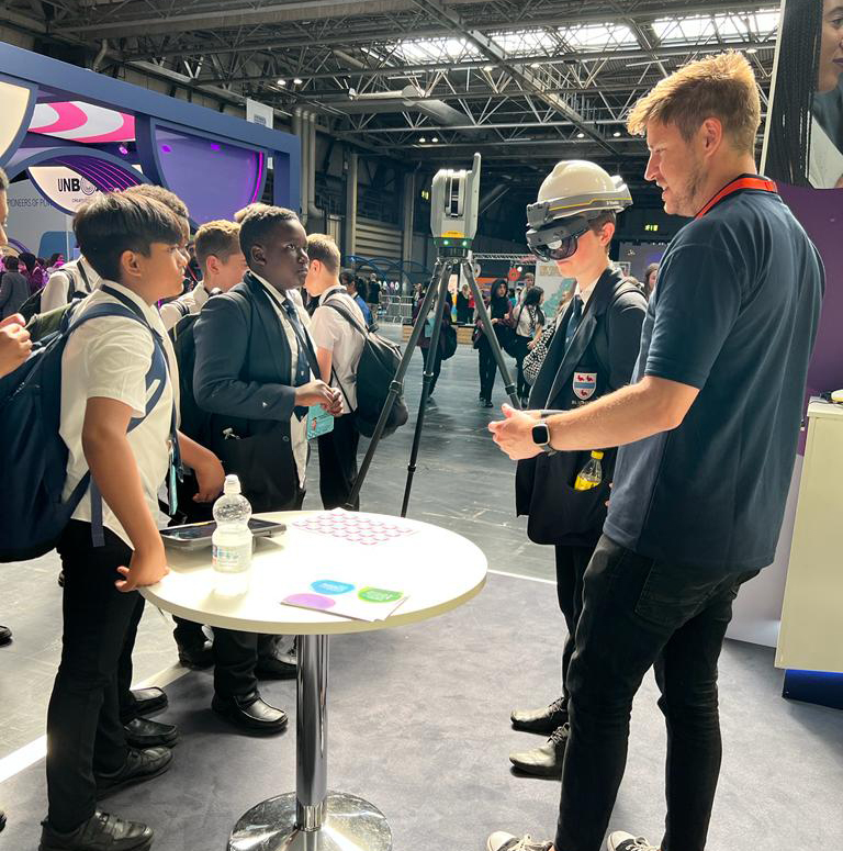
KOREC & National Highways make a Big impact
Our team were delighted to support National Highways at the recent Big Bang Fair in Birmingham.
The 3-day event saw tens of thousands of children aged 11-14 descend on the NEC to get involved in all things STEM (science, technology, engineering and maths).
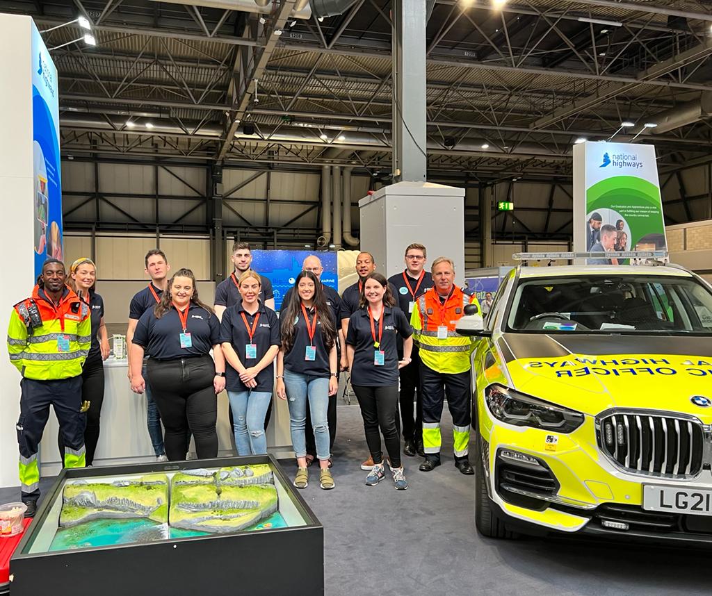
The KOREC team were on hand to showcase the very cool technologies that are being utilised to made the collection, sharing and understanding of spatial data easier and more intuitive. The star of the show was most certainly the Trimble XR10 headset. The team loaded various digital models including dinosaurs, robots and an airplane into the device, which the kids could then view and explore!
Check out more photos of the event and the team, here!
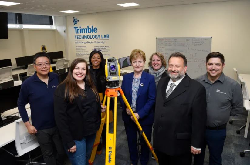
Trimble Technology lab expands in Edinburgh
Trimble and Edinburgh Napier University are celebrating the expansion of the Trimble Technology lab – the first of its kind in the UK.
Click here or the link below to read the complete story over on the North Edinburgh News site.
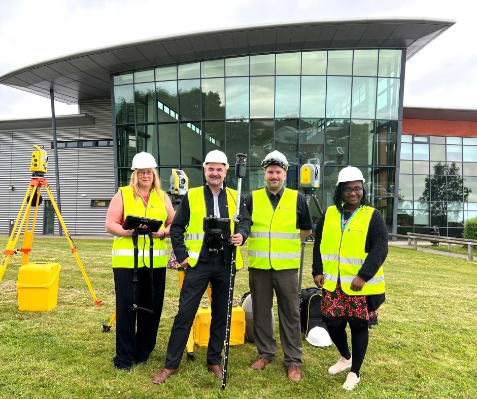
SMB College Group invest in Trimble Technology
Leicestershire-based SMB College Group has recently invested over £80,000 in Trimble technology, supplied by KOREC Group.
The college is a leader in Construction T level courses – preparing its students for work in the construction and engineering sectors including quantity surveying, civil engineering, project management and architecture.
The equipment includes some of Trimble’s most cutting-edge digital construction solutions, including the X7 laser scanner, the XR10 mixed reality headset, and the S5 robotic total station.
Read the full press release on the SMB College Group site
Next Generation is KOREC’s higher education strand – it’s how we inspire, support and train the institutions and the students who are the future workforce of our industry.
If you’d like to know more about Next Generation, or how we can help you, why not get in touch?
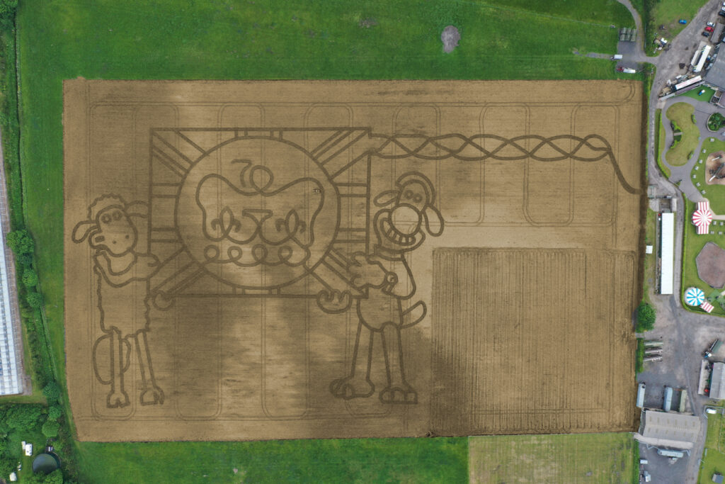
It’s taken permission from the Palace and the loan of one of the most advanced handheld GPS mapping systems available for Mark Edwards, Managing Director of Farmer Ted’s Adventure Farm, Ormskirk, Lancashire, to create this year’s jubilee themed maze attraction.
The maze was designed by Mark who enlisted the help of Liverpool based positioning and survey equipment specialists, KOREC Group. KOREC was delighted to loan him a handheld Trimble Catalyst GPS solution and also helped him turn the design into coordinates that could be loaded into the GPS to recreate the design in the maize field.
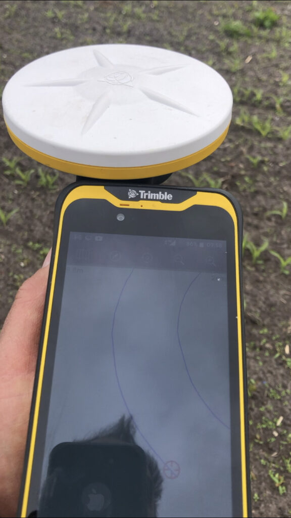
The Trimble Catalyst GPS connects to a smartphone that clearly shows the maze design. It is then taken onto the 14 acre maze site where Mark is able to navigate, using his position on the screen, to plot out the design amongst the tiny maize plants. A cultivator follows his trail cutting out the design.
Left:The KOREC supplied Trimble Catalyst GPS is capable of centimetre accuracy! This picture shows part of the design on a smartphone/logger
This year’s design comes with a royal seal of approval. Working closely with Aardman, the award winning animation studio and the creators of Shaun the Sheep, Mark contacted the Lord Chamberlain’s Office at Buckingham Palace and was granted permission to use the Queens official Platinum Jubilee logo to celebrate this great occasion!
Mark says, “the KOREC supplied Trimble GPS really is an ‘amaizing’ piece of equipment and so easy to use. We were able to create this exciting jubilee design in just 2 days!”
Farmer Ted’s is the UK’s largest Shaun the Sheep farm attraction. It opens daily until mid-September with the Maize Maze opening on 23rd July. Tickets can be purchased on-line at www.farmerteds.com
About Shaun the Sheep
Shaun the Sheep, Aardman’s family favourite TV series, is recognised the world over for its slapstick humour, distinctive look and strong, quirky characters and enjoyed across multiple media platforms. First appearing in Nick Park’s 1995 Academy Award® winning Wallace & Gromit ‘A Close Shave’, Shaun then went on to star in his own series, created by Richard Starzak which launched on BBC One in 2007. Shaun the Sheep is currently broadcast in 170 territories around the world and is an internationally celebrated icon with over 5.6 million fans on Facebook. In 2015 the first Shaun the Sheep Movie with feature film partner Studiocanal was released around the world to critical acclaim and the first half hour TV special aired as part of many broadcaster’s festive season., The feature film sequel Shaun the Sheep Movie: Farmageddon was released in October 2019 and nominated for an Academy Award® and was closely followed by a sixth season of the series in 2020. A new festive special Shaun the Sheep: The Flight Before Christmas was released in December 2021.
The onset of the COVID-19 pandemic two years ago really brought home to us the importance of maintaining and improving our health – both inside and out.
Maintaining our physical health could mean the difference between a mild or a severe case of covid, and the impact of multiple lockdowns, separation from our loved ones, and working from home, all took their toll on our mental health, too.
Combined with the distressing and upsetting news coming out of Ukraine on an almost daily basis, it does seem a challenge to keep ourselves upbeat and positive.
As a responsible employer, KOREC understands the importance of ensuring a happy, healthy and supported workforce – and takes action to ensure it.
To mark this International Day of Happiness, here’s just some of the initiatives we’re undertaking to bolster the health, happiness and prosperity of our people;
Perks of the Job
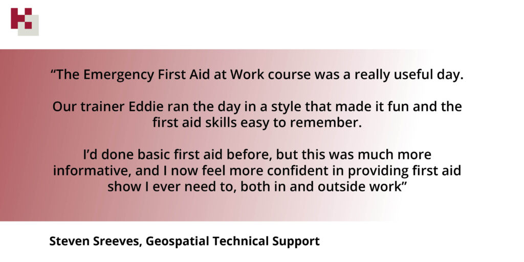
The company now proudly boasts 5 physical first aiders, including Steven Sreeves who just completed his Emergency First Aid at Work training, provided by St John Ambulance
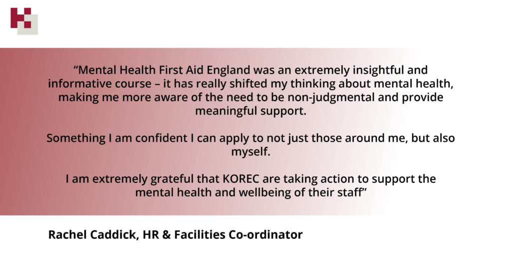
- We’re also proud to have two mental health first aiders, in the shape of Rachel Caddick and Stuart Guthrie-Cadge, both of whom recently completed the Mental Health First Aid England course.
- Rachel and Stuart recently held a Lunch ‘n’ Learn on the difficult but important subject of depression, anxiety and suicide – and offered advice and tips for those who may be struggling.

Meet the KOREC mental health first aiders! Rachel Caddick and Stuart Guthrie-Cadge
- We’ve signed up to Plumm – a dedicated online platform that offers free and confidential chat therapy, online courses and meditation
- We recognise the importance of small gestures, which is why we send every single employee a small Valentine’s gift each year, just to let them know we appreciate them.
- Speaking of small gestures, who doesn’t love a wee perk? For a few years now KOREC has invested in Perkbox, an online portal chock full of freebies and discounts on everything from free cinema tickets to cheaper gym discounts. This also includes access to the Employee Assistance Program – providing 24/7 support for those struggling with legal issues, debt, anxiety, bereavement or relationship issues.
- We also love to party! Which is why we have not one, but two KOREC parties – a summer and a Christmas event! The KOREC gang love nothing more than getting together and having a knees up. During COVID, we thought this was more important than ever, so we held our first ever ‘virtual’ Christmas party, and smaller, socially-distanced summer events.
On this International Day of Happiness, why not take a few moments out of your day to do something that makes you feel good?
Wishing you health, happiness and prosperity – from the whole KOREC team!
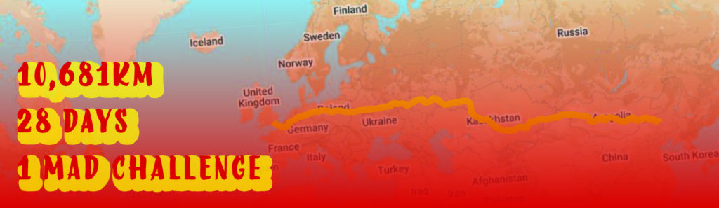
1st February 2022 marks the beginning of the Chinese New Year. Three days later, on Friday 4th, the Beijing Winter Olympics begin.
To mark these two occasions, and because we are mad for a group fitness challenge (or just plain mad?) the KOREC team are committing to undertake a mammoth journey.
In February 2021, our UK and Irish teams undertook their ‘Fit4Feb’ challenges – traversing Europe and America (virtually, of course…), and totting up an impressive 6,200km between them.
This year, in the spirit of the Chinese New Year – the year of the Tiger – we’ve committed ourselves to an even bigger challenge.
We are going to walk, run, swim, cycle and hop our way back from Beijing to London – a distance of a whopping 10,681km!
The well-known quote ‘a journey of a thousand miles’ is attributed to the Chinese philosopher Lao Tzu, and seems particularly apt for the challenge that lies ahead – at first, a journey of over 6,000 miles seems impossible – but all we can do is take that vital first step and begin our journey – and crucially – we’re not alone!

The Year of the Tiger
Since 2022 marks the year of the tiger, we’ve taken some inspiration from our furry friend. According to the Chinese Zodiac, the tiger is the ‘king of all beasts’, and is a symbol of Bravery, Competitiveness, Unpredictability and Confidence – some familiar traits we can see in ourselves!
So we’ve set some mini challenges based on these qualities, with some awesome (tiger-themed) prizes up for grabs!
BRAVE
- Who is brave enough to join our challenge?
- Who will brave dark and dismal early mornings for an invigorating run?
- And most importantly, who is brave enough to share their most embarrassing workout outfit?!
COMPETITIVE
- Who will get the most miles under their belt?
- Who can most accurately guess where we’ll end up come 28th February?
UNPREDICTABLE
- What will we discover en route?
- Who will come up with the most wacky method of exercise?
CONFIDENT
- Who actually thinks we can go the distance?
- Who’s willing to give it a go anyway?


We hit the ground running on February 1st, and we’ll be providing regular weekly updates on our progress throughout the month via our social channels.
Wish us luck, or as the Chinese say – Zhù nǐ hǎo yùn!
KOREC is delighted to announce that group expansion means we are now seeking to fill 30 new positions, in a range of departments, across the UK and Ireland. These new roles include openings in our offices in Cambridgeshire, Dublin and Liverpool.
World beating technology for curious minds
KOREC specialises in bringing world leading geospatial technology to the UK and Irish markets, all backed up by in-house software development, training, technical support and servicing.
Through partnerships with companies such as Trimble, Esri and Parrot, KOREC aims to provide its customers with a wide range of ground-breaking geospatial technology. This offering includes everything from high accuracy GPS, 3D Laser Scanners, drones and robots to AI, Mixed Reality and Mobile Mapping solutions.
High profile customers
KOREC customers include some of the biggest names in the UK and Ireland including National Highways, United Utilities, Irish Rail, Network Rail, F1, Ordnance Survey, National Trust, Costain and Balfour Beatty; some of the smallest from sole ownership survey companies and drone operators to environmentalists and soil scientists; and let’s not forget some of the more unusual – Munro baggers, and mapping professionals involved in tropical disease vaccination projects or landmine clearing.
We have openings available for those in the industry and for those with no previous geospatial experience but looking to work in a fast-moving, technology led company. These roles include positions in sales, software development, recruitment, administration, technical support, training, marketing and servicing.
Alan Browne – KOREC CEO said “We may be a fast-growing company in a technology led industry but our 50 years in the business mean that we’ve had time to build and define our company culture and that means we’ve also created a great workplace and a world-class ethos. Our staff tell us that KOREC is a rewarding and exciting place to work and that’s something we’re really proud to have achieved.”
For further information, please visit https://www.korecgroup.com/careers-at-korec/
We are adding these new roles to the website regularly.
ENDS
Peterborough based KOREC customer, Sky Revolutions, is a company that certainly knows its way around the aerial mapping sector and as one of the very earliest UK surveying businesses to realise the benefits of drone surveying, it also has an extensive knowledge of the technology involved.
That’s why we are delighted to announce that it has become the first company in the UK to take delivery of senseFly’s newly released fixed wing drone, the eBee GEO.
Designed to deliver senseFly’s superior build quality and extensive functionality at a fraction of the price of similar drones, the eBee GEO is all about user ROI and is especially suitable for the many varied projects that Sky Revolutions undertake.
For company Director, Ben Gorham, the eBee GEO is a perfect choice for Sky Revolutions which has seen an upsurge in demand for aerial survey work following the restrictions imposed by COVID.
Ben rates the eBee GEO for four particular reasons:
- The RTK option allows the Sky Revolutions team to achieve the 2.5cm accuracy demanded by many of their projects
- With a battery life of 45 minutes, the eBee GEO is a producitive choice for the increasing number of larger jobs the company is working on
- The S.O.D.A. camera provides impressive accuracy at 400ft
- Some of Sky Revolutions’ jobs, such as a recent coastal survey in Suffolk, involve several miles of walking. The eBee GEO has a take-off weight of just 1.3kg and is easy to transport in a backback.
Ben concludes, “There’s no doubt that the eBee GEO makes good sense for us financially and with its impressive accuracy it is the perfect addition to our fixed wing offering. KOREC’s been great at meeting our requirements and understands that we are a company valued by our customers for our specialist surveying skills and consequently have high expectations of every investment we make.”
Sky Revolutions has just successfully completed a first mission with the eBee GEO carrying out a coastal survey on behalf of Suffolk County Council.
Sky Revolutions pick up their new eBee GEO from KOREC’s Huntingdon base. From left to right, James Tindall (KOREC Geospatial Technical Support), Lloyd Wilkinson (KOREC Geospatial Sales Consultant), Ben Gorham (Director, Sky Revolutions), Madison Gorham (Apprentice, Sky Revolutions), Anna Carter (Office Manager, Sky Revolutions)
Madison Gorham (Apprentice, Sky Revolutions) and Anna Carter (Office Manager, Sky Revolutions)
KOREC is delighted to announce that following extensive behind the scenes work demonstrating our ongoing commitment to support the Esri user community, we have been recognised officially as an Esri Silver Tier Business Partner.

This new status will further strengthen the KOREC/Esri relationship allowing KOREC to offer Esri’s ArcGIS software as part of its mapping portfolio to new and existing KOREC customers.
Silver Tier status will also provide Esri UK’s customers with access to KOREC’s in-house software development team and its specialist knowledge on the integration of Trimble GNSS into Esri mobile data capture software.
Potential development for Esri clients will include everything from small tweaks to bespoke workflows based on the ArcGIS system, bringing all the power of their existing software but with customisation options for specific data capture workflows.
The Trimble Catalyst solution with a TDC600
The KOREC mapping team will also be available to assist Esri users with the integration of GNSS into their workflows with up to centimetre positional accuracy. Esri users will now have access to the most cost-effective method possible for cm accuracy by means of Trimble’s subscription based, low cost Catalyst solution.
To discuss all development requirements please contact KOREC Business Area Manager – Mapping & GIS, Richard Gauchwin on 07786 118436 or at richard.gauchwin@korecgroup.com
Or visit www.korecgroup.com/mapping