As a result of their recent successful integration into Cansel Group, KOREC Group and Survey Solutions Group (SSG) are pleased to announce that both companies are now authorised Propeller distributors covering the UK, Scotland and Ireland.
The two companies will sell and support Propeller’s leading cloud-based platform for drone mapping, 3D site analytics and earthworks management.
KOREC and SSG customers will have a proven solution for processing and analysing drone data across a range of applications including surveying, mapping, construction, housebuilding, aggregates, mining and waste management. The Propeller distributorship will also enable KOREC and SSG to expand into the BYOD (bring your own data) market.
Compatible with all the major UAVs sold by both KOREC and SSG, Propeller can also be fully integrated into the Trimble eco-system via the Trimble Connect common data environment.
Benoit Mallen, President UK and Ireland, Cansel Group said:
“At Cansel, with KOREC Group and Survey Solutions Group now fully integrated, we’re committed to delivering user-friendly field-to-finish workflows. The Propeller agreement brings their leading cloud-based drone mapping, 3D analytics, and earthworks platform to customers across the UK, Scotland, and Ireland enabling faster, more actionable insights from drone data in surveying, construction, aggregates, mining, waste management, and more.”
Sam Long, Account Executive, Propeller Aero said:
“We’re excited to welcome KOREC and SSG as new distributions for Propeller Aero. KOREC and SSG have built an outstanding reputation within the geospatial industry, and their expertise and strong relationships across the sector make them a natural fit for Propeller. Since they already provide many of the survey-grade drones our customers rely on, this partnership makes it easier for surveyors to process drone data, reduce photogrammetry workloads and share accurate site insights with teams across the business. We’re really looking forward to bringing the Propeller platform to KOREC and SSG’s customers and helping them unlock the value of accurate aerial data and streamlined site workflows.”
For more information or to arrange a demonstration, please contact www.korecgroup.com/contact or www.surveysolutionsgroup.co.uk
Propeller will be attending KOREC’s upcoming UAV days in March and April with further dates in Scotland to be announced by SSG.
Download a PDF of the release here
About KOREC Group
KOREC Group specialises in the provision of intuitive software and world lead positioning technology for the measurement, mapping and management of the natural and built environment.
KOREC is the UK and Irish distributor for Trimble and operates nationwide out of offices in Huntingdon, Liverpool, Dublin and Craigavon (NI). .In December 2025, KOREC joined the Cansel Group, a respected leader in geospatial technology with established operations across Canada and North America. www.canselgroup.com www.korecgroup.com
About Survey Solutions Group
Established in 1993, Survey Solutions Group provides high quality survey systems, for sale or hire, backed up by its service and repair centre, technical support and training service.
In 2001 it became the only authorised Trimble distributor in Scotland for all Geospatial solutions and in 2025 joined the Cansel Group, a respected leader in geospatial technology with established operations across Canada and North America. www.canselgroup.com http://www.surveysolutionsgroup.co.uk/
About Propeller
Propeller Aero is a leading global provider of cloud-based drone mapping, 3D site analytics and earthworks management solutions. Founded in 2014 in Sydney, the company has grown from a startup into a trusted industry player with offices in Denver, Manila, and Amsterdam. www.propelleraero.com
“Surveying isn’t just about surveyors, right?… it’s about the power of spatial understanding for everyone.”
That’s what Barry Bassnet published on LinkedIn recently – and let’s just say his post sparked more interest than a KOREC consultant arriving on site with a bag of warm doughnuts! And why did he make this comment? Because he’d just seen a demonstration of Soarvo, a new cloud-based platform that reimagines how 3D spatial data should look, feel and function for a much broader audience, one that’s well beyond the usual circle of geospatial professionals.
Barry suggested that we’ve become so laser-focused on CAD deliverables that we risk reducing rich, multi-dimensional data into flat lines on a page. Accurate lines, for sure -but certainly less accessible to the many people who could actually benefit from the data; a list that includes project managers, planners, environmental consultants, utility specialists and even the general public. These are the typical stakeholders who need to understand space and context so why not give them a format that makes sense, and why not ensure that the software that provides this information is truly visual with a user interface so intuitive that nobody needs expensive training on how to use it?
…and the solution is Soarvo
Here at KOREC we have the means for our customers to do exactly that thanks to Soarvo. Humans are visual creatures (we process visuals 60,000 times faster than text) and Soarvo taps into that by presenting survey data from any number of different sensors in an intuitive, interactive 3D environment that even the non-technical can navigate with ease. Remember how Google Earth revolutionised map navigation…that’s what Soarvo can do for survey data.
We’ve already talked about Soarvo functionality in an earlier blog ‘Born of Frustration’, and how it can unlock the full value of geospatial data but today we’re not here to talk about some hypothetical use case, it’s time to show the results from real world projects and where better to start than with a Soarvo highlight – the drone workflow.
We therefore despatched our KOREC drone specialist to undertake two drone focused projects that would not only showcase Soarvo’s data handling and processing but also the Wingtra Gen II drone with VTOL:
Drone project 1: Into the woods
Our first mission? A dense forest survey to assess tree density and map the terrain for flood risk analysis. For this, the Wingtra Gen II, fitted with a LiDAR sensor, was the obvious choice thanks to its ability to penetrate through thick canopy and deliver multiple returns.
Once complete, the LiDAR was swiftly swapped out for Wingtra’s premium RGB61 camera and the site was re-flown at 100 metres (up from 80m). Same flight plan, fresh perspective.
Processing the Data
Data was processed in the Wingtra LiDAR app, then seamlessly uploaded into Soarvo – a simple drag and drop – and instantly ready to be explored, analysed, and shared with a far wider audience, all with zero fuss.
Soarvo standouts on this project
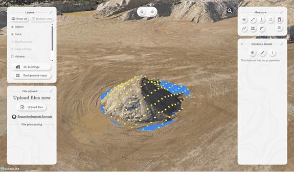
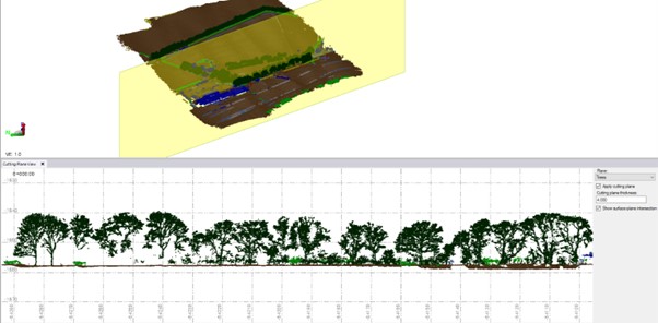
- See the forest and the ground: The Wingtra Gen II with LiDAR cuts through the forest’s canopy to ground level. Once in Soarvo, the point cloud can be colourised by height and then a clipping plane used to show data just at ground level for better assessing flood risk.
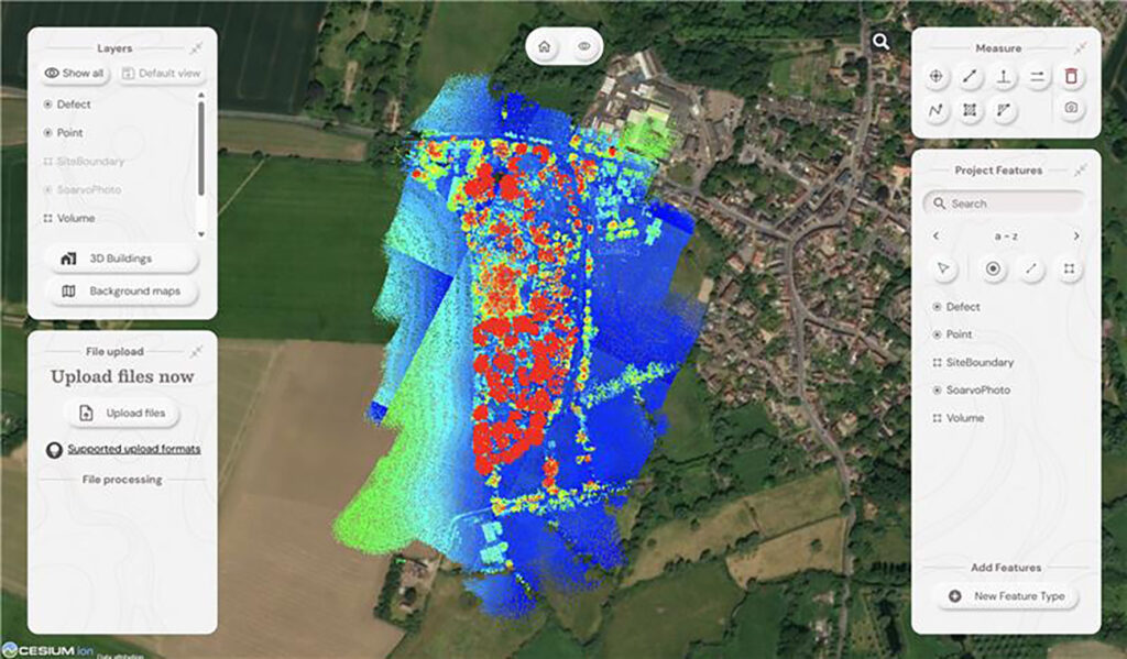
Point cloud colourised by height
- Focus only on what you need: Soarvo has the ability to read point cloud classifications and remove the ones not relevant to your application from view. In this case we created a purely ground level view to analyse the natural drainage within the forest and to examine where the ditches converge and assess what is happening in these vulnerable areas.
Showing the natural drainage within the forest
- RGB data rendered in seconds: With the RGB61 sensor data, we produced an ultra-accurate 3D model of the forest that loads and renders impressively fast. Bonus: Soarvo allows you to drape the orthomosaic over the terrain, offering a rich, contextualised visual that’s miles ahead of a flat 2D map.
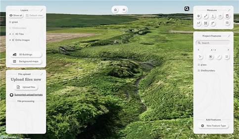
Orthomosaic draped over the terrain
- Snapshots with measurements: The ‘Snapshot’ tool came in handy for exporting JPEGs with embedded measurements. This function is ideal for briefing teams and stakeholders – no confusion, just clear visuals with context.
- Buit in GIS – done properly: Unlike most platforms, Soarvo includes full GIS functionality. Create features, draw polygons, and record detailed attribute data – not just vague notes. A great time saver, everything in one place, exactly where you need it.
Permission to fly the forest kindly granted by Phillip Wilcox-Moore, Managing Director, Axter Ltd. We’ll be covering this community story in an upcoming case study.
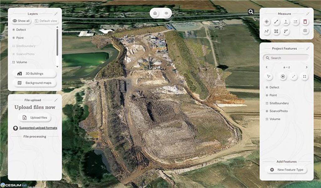
Drone Project 2: No stone unmeasured
Next up, a quarry stockpile survey. This time, it was all about volume calculations with a single flight using the RGB61 sensor. Just 7 minutes and 152 images later, the job was done.
Processing the drone data:
This data was processed in Soarvo by simply uploading the raw images in a zip file. Once loaded, Soarvo takes care of the rest generating an orthomosaic, 3D mesh and point cloud. No third-party software required, no CAD skills required and all processed and ready for sharing in typically, under an hour.
Soarvo standouts on this project
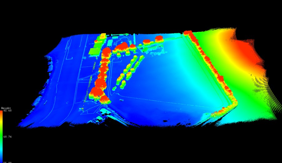
- Calculate volumes, fast! Let’s start with the main aim of this project, volume calculations – a regular need in quarry operations because that’s where the value lies. With Soarvo, it’s refreshingly easy, simply draw a polygon around the stockpile base, hit ‘calculate volume’, and you’re done. As accurate as traditional GPS-based surveys only faster, easier, safer and with the option for putting down more points for even higher accuracy, all completed from the desk.
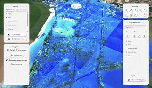
- Context matters: Unlike many platforms, Soarvo shows your drone generated point cloud in full context – no black voids, just clean, continuous terrain on a choice of background mapping that adds the sort of extra context you need for a true real-world view, ideal for planning access, security etc.
- More ways for easy visualisation: Simply use the ‘snapshot’ function with added notes or measurements for easy insights without any technical expertise required.
Quarry point cloud shown in context to surroundings – no black void!
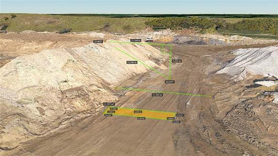
‘Snapshot’ with measurements
Calculating stockpile volumes – add as many points as you wish

Volume calculation report
And general to both projects – four more Soarvo benefits
No limits on the number of people who have access to the data
It’s all about making spatial data more accessible to more stakeholders – securely and without limits. Anyone you grant access can view the data straight from a web browser, no installs, no restrictions.
Security is vital, so it’s named user access only
Importantly, by avoiding use of a hyperlink, security is increased and Soarvo users can share this data only through named user access. Data security has been a key building block in the development of Soarvo since its conception.
Unique to Soarvo – merge and view ALL your data in one place
With Soarvo, you can bring together all your datasets – regardless of sensor type – into a single, cohesive view. But it doesn’t stop there. You can create layers of other key information too, like CAD-based topo surveys, GIS data with feature and attribute details (eg, boreholes), or even supporting documents like drainage reports. Just click to open with no digging around. It’s a genuinely useful feature, and a unique one that sets Soarvo apart.
Add context to your data – no black voids here
Soarvo provides context around your dataset and positions it in the real world rather than a giant black void. For example, your laser scan point cloud doesn’t sit in a black space, it’s positioned on to the background map of your choice from OS to Google to Bing. This opens up new doors with your clients who may need great data to check access to site etc.
And to sum up….
Undoubtedly CAD remains vital to our industry and is understandably widely popular, but as technology evolves, it becomes only part of a far richer story. The real value lies in how we make our geospatial data accessible, visual, and useful to everyone, not just specialists. And simply, that’s what makes Soarvo so exciting and relevant to an industry that needs its data to work harder and smarter – for us all.
Find out more about Soarvo by contacting KOREC for a chat or demonstration and visit Soarvo Stand G361 at GeoBusiness 2025.
KOREC Group is delighted to announce that it has become a top level, Tier 1 reseller for DJI’s Enterprise drones through an agreement with Midwich Ltd, a key distributor of DJI Enterprise’s drone solutions in the UK and Ireland.
This new agreement will see KOREC further expanding its drone and UAV portfolio which already includes Wingtra, Parrot and AgEagle products.
The DJI Enterprise range, including Matrice and Mavic rotary drones as well as Dock solutions, will provide KOREC geospatial customers with a comprehensive, one-stop solution. This offering combines cutting-edge products with certified pilot training, technical support & consultancy, processing software and cost-effective GNSS technology for establishing ground control points (GCPs), all backed up by KOREC’s T.R.U.S.T. brand promise.
John Cartledge, Mapping & GIS Business Area Manager, KOREC Group said:
“We are delighted to achieve Tier 1 status, the highest grade of partnership with DJI, and to bring their innovative portfolio to these markets. Our mapping and GIS team has undergone rigorous technical and product training to meet DJI’s exacting standards.
With our proven ability to provide end-to-end solutions for drone operators and service providers — including pilot training, processing software, and GPS control (Catalyst) — we deliver everything needed for imagery, thermal, multi-spectral, and LiDAR applications. Whether tackling small-scale or large-scale projects, KOREC is equipped to meet every requirement.”
Adam Box, Sales Manager (Drones and UAV) for Midwich Ltd said:
“We are delighted to announce that KOREC Group has officially joined the DJI Enterprise family as a reseller, further strengthening our dealer channel at Midwich Ltd.
With their extensive expertise in geospatial solutions and commitment to delivering cutting-edge technology, KOREC Group is perfectly positioned to represent DJI Enterprise’s innovative drone solutions. This partnership marks an exciting step forward in expanding the reach and support for DJI Enterprise across the UK and Ireland.”
To learn more about DJI Enterprise drones, look out for details on our upcoming launch event and webinar or contact us now
Following a number of recent test flights, KOREC’s Darrell Theobalds reports back on where the WingtraOne Gen II scores high, what’s on his wish list and what he truly rates.
Does the WingtraOne deliver?
For KOREC’s sector specialists, the good news is that they always get their hands on a new addition to the KOREC portfolio before anyone else! This time it’s the turn of our drone specialist, Darrell Theobalds, who has been putting the WingtraOne GEN II through its paces.
KOREC has recently become a Wingtra partner to further strengthen the existing KOREC fixed wing portfolio and Darrell, with his extensive experience supporting and training our drone users, understands better than anyone the challenges drone operators face in the field as well as what’s required to overcome them.
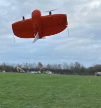
Developed in Switzerland, the WingtraOne GEN II is a premium surveying drone aimed at those who seek consistent high-quality drone data and comes with the tag line ‘Map Faster, Map Larger, Map Anywhere’.
Does it deliver? Darrell reports back on his testing:
How I tested the WingtraOne GEN II
I’ve completed six flights in two separate locations so far with the WingtraOne; three with the new LIDAR payload and three with the RGB61 high-resolution mapping camera. Two of the flights with the LIDAR were in wet conditions and the other was on a very windy day. With the RGB camera, we undertook two flights on sunny, calm days and again, one in very wet weather.
A flight with the WingtraOne and LIDAR payload lasted 4mins 40 sec producing a 183 pt/m2 point density cloud and coving an area of 13ha. The point cloud size was 470mb whilst processing time in the Wingtra LIDAR app took 10 minutes.
First Impressions
Before we get into what’s included with the WingtraOne, it’s worth mentioning the case itself – this is professional packaging! The drone comes in a robust, thoughtfully designed container guaranteeing the safety of both the drone and its sensors during transport. The inclusion of a hardcase for shipping and soft backpack carrier for easy transportation means you’re equipped to take it on a plane, or venture across remote countryside.
With the case open, the first thing to note is that the Wingtra is bright orange for easy spotting and has a sleek and modern design reflecting its professional-grade capabilities. It’s also extremely compact. This is good to see because power lift drones can be complicated instruments, so this sleek design definitely showcases the ingenuity that’s been put into its development.
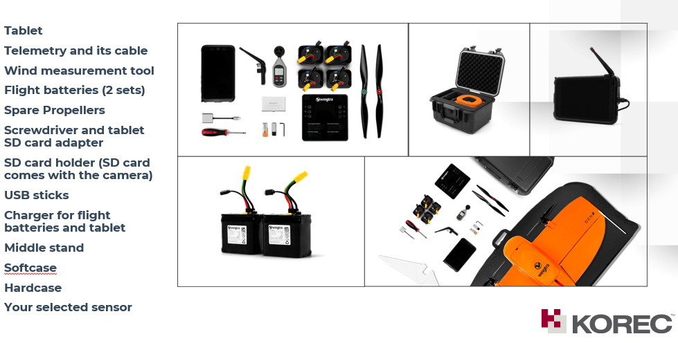
What’s in the box?
Once you open the box it’s a comprehensive set up. The standard WingtraOne GEN II package comprises not only the drone itself but also a complete set of essential accessories. This includes four batteries, a smart charger, a ground control station Samsung tablet, communication modules, an anemometer, and various accessories for data transfer. Altogether, it’s a carefully curated selection of accessories that are essential for the field data collection.
Getting set up
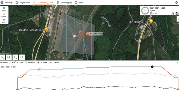
Setting up the WingtraOne for flight is typically straightforward, thanks to user-friendly instructions, an online knowledge base resource repository of eLearning tools and intuitive design. To start up flights with the Wingtra, you need to set down on a level surface parallel to the wind, insert the middle stand, insert the payload and connect the battery. Then plan your flight, go through the Wingtrahub check list and off you go.
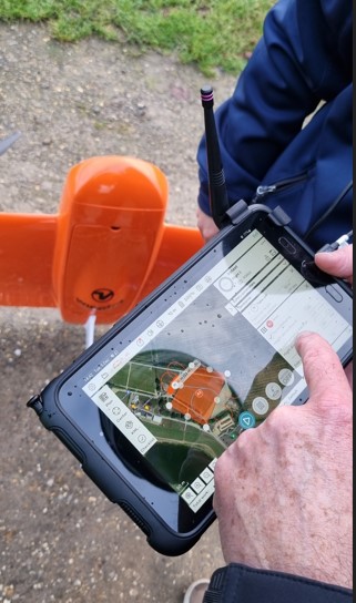
Preparing to fly – intuitive software
WingtraHub is the Windows software for PPK image geotagging and desktop flight planning and has a simple flight check wizard. This means there is limited chance of error as you would not be able to take off if the initializing process was compromised or if you missed a step.
The Wingtrahub allows the user to plan area and corridor flight import mission parameters from KML and view this mission plan against the terrain. Again, a well-engineered thought-out application.
VTOL! Abolutely one of my Top 5 features
The benefits of fixed-wing and multirotor drones with VTOL (Vertical Take-Off and Landing) capability always appeal to me as I have had a fair number of challenges with sites that are extensive but have limited take-off and landing location.
Powerlift drones like the Wingtra enable vertical take-off and landing like a multirotor drone while also having the efficiency of a fixed-wing aircraft during flight. I have flown fixed wings for the past 12 years and the challenge has always been landing and taking off at confined sites, especially when the landing location has obstacles and you are restricted because you need to land into the wind.
The time spent trying to find the safest location to take off and land can now be spent flying. With the additional functionality of pausing and manually landing like a rotary, it’s really the best of both worlds. Only last week, at a Yorkshire racecourse, I had a flight planned with winds gusting at 30mph and averaging 17mph. I was able to take off and land with no issues. The updated Wingtrahub software and manual override for land, made landing in these type of winds very controlled and safe.
High precision mapping – sensor choices
WingtraOne is equipped with high-resolution cameras like the RGB61 and advanced sensors like the multispectral mica sense and Wingtra LIDAR to capture detailed imagery and data for real-world mapping and surveying purposes. This combined with the PPK base data can provide users with deliverables up to 1cm accuracy. I used both the RGB61 and the new LIDAR and was impressed with the results, they both performed remarkably well in windy conditions with no downwash or blurry images. Their solid performance also gave me total confidence that I was achieving one of the things that can save the most time on a job, ‘getting it right first time’.
In the air – what I liked
Long Range and Endurance:
With its fixed-wing design coupled with vertical take-off, WingtraOne can cover large or small areas efficiently in a single flight.
Thanks to its impressive flight range and endurance, the Wingtra can efficiently map vast areas without the necessity for frequent battery swaps or recharges. Moreover, it’s not limited to large expanses; it’s versatile enough to capture smaller sites as well.
Post-Processing Software Integration:
The exports from Wingthra Hub can be processed using various photogrammetry and GIS software packages, outputting the standard point clouds in LAS or Laz, the mesh file in OBJ, your Orthomosaic in Geo tiff or jpeg. Typically, all I need is a combination of Pix4D and Trimble Business Center to accomplish my tasks.
Impressive Performance:
I was impressed by WingtraOne’s performance in the field, including its long flight endurance, high-quality imaging capabilities, and reliable autonomous flight missions. I flew in high gusts of up to 30mph and landed in winds over the max of 17mph which meant the unit can be pushed to its limits while still providing good data. As I mentioned, the lidar sensors and RGB61 sensors performed remarkably well in windy conditions with no downwash or blurry images.
LIDAR camera impressions
February of this year saw the introduction of Wingtra LIDAR. Integration of LIDAR systems typically involves mounting the LIDAR payload onto the drone’s payload bay and ensuring proper integration with the drone’s flight control system and data capture workflow. This will involve some calibration to prevent distortion and incomplete point clouds.
Contrary to belief, LIDAR does not penetrate the leaf. Instead, the light passes through gaps in the foliage, reaching the ground through multiple scans.
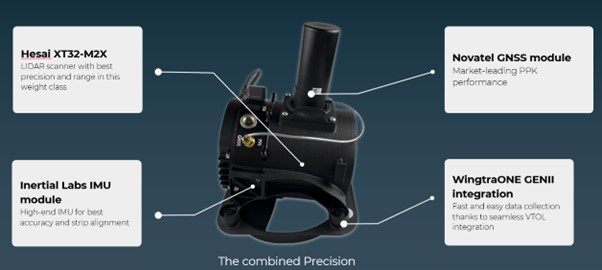
The Wingtra LIDAR sensor has 3 components: a Hesai LIDAR scanner, an inertial Labs IMU and a NovAtel GNSS.
HESAI Technology, a renowned global provider of LIDAR sensor solutions, supplies sensors utilised in various fields including ADAS, autonomous mobility, trucking robotics, AI, and numerous industrial applications. The knowledge that the WingtraOne GEN II is powered by a Hesai sensor instills a certain level of confidence and trust, customers know they are investing in reliable and high-quality product.
Navigating the workflow was straightforward for me. I initiated my flight plan using Wingtrahub, executed the data capture with Wingtra Pilot within a 4-minute flight, processed the raw data in the Wingtra LIDAR app (taking approximately 10 minutes), and finally conducted further data processing in Trimble Business Center. Within 40mins I had usable deliverables from the flight data.
The most common questions I get asked about Wingtra LIDAR and the answers!
The common inquiries I receive revolve around the flight duration, the extent of necessary editing, the processing timeframe, and the quality of data captured beneath tree cover.
The responses are 3%-5% decline in flight duration due to the weight of the camera, minimal editing is required, and the data beneath tree cover results are better than average for a 3 return LIDAR sensor.
One of the standout features of this LIDAR solution is its self-calibration capability. Unlike other units that require calibration during flight, resulting in lost flight time due to back-and-forth adjustments, the Wingtra ensures that you maximize your entire flight duration, allowing for a full flight.
You do lose some flight time because of the weight but because of the angle of coverage and overlap you can cover a wider area along the flight lines. So, transitioning between the RGB and LIDAR sensor does not impact coverage as it relates to flight time.
With a wide angle of 90 degrees, coupled with extended flight times, it can cover more ground with each pass. For instance, during a 90-meter flight, the LIDAR can cover 360 hectares while maintaining accuracies of 3cm. This represents up to a 50% increase in coverage compared to sensors of similar range.
There is no misalignment after processing with the Wingtra LIDAR so there is very little to do when processing the raw outputs.
It took me a few minutes after flight to export the raw LIDAR trajectory data, clean the runs and export the Las file for processing in our Trimble Business Centre software. The Wingtra LIDAR app enabled me to select the end and start of runs processed and export to the required coordinate system.
I do not think this is out to replace your LIDAR rotary solution as there are solutions where you will need to fly slower and require more returns to achieve that level of detail, but you lose the coverage and spend days in the field, all impacting cost, The Wingtra LIDAR solution has a strong place in the market and I was impressed by its performance.
In conclusion – my top five WingtraOne GEN II rated features
- The Wingtra’s VTOL functionality allows you to work at confined sites
- The speed and precision allow flight to cover larger areas than Rotary
- There is a wide selection of payloads for the WingtraOne GEN ll
- Wingtra LIDAR substantially reduces the need for labour-intensive post-processing strip alignment, providing precise terrain data immediately following each efficient flight.
- One of the notable advantages of Wingtra LIDAR is its ability to minimize field time, requiring no calibration and initializing in just one minute.
- The user-friendly Wingtra LIDAR app and automated experience empower users
And in a perfect world….
In all honesty the WingtraOne delivers high-quality data in demanding conditions and I’ve been extremely impressed, especially with its wind handling. Does it deliver on its promise of ‘Map Faster, Map Larger, Map Anywhere’, absolutely yes it does.
Is anything missing from the package? Not at all, the Wingtra is a premium drone and its performance, build and ease of use reflect that at every turn. However, if you really pushed me, for a wish list for future upgrades it would include live link flight mission updates or real-time viewing of data imagery, but that’s about it. Watch this space for future updates and in the meantime, for further information, please view my recent WingtraOne webinar here. or contact us for a demonstration at info@korecgroup.com
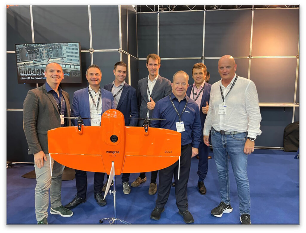
From left to right Matthieu Lefebvre, (Head Of Sales EMEA), Mark Poveda (Group Commercial Director, KOREC), Shane Murtagh, (Sales Director, Ireland, KOREC, Maximilian Boosfeld, (Wingtra Founder), Adam Box, (Regional Sales Manager UK & Benelux, Wingtra), Aleksander Kostadinov, (Global Sales Director), Alan Browne, (Group Chief Executive, KOREC)
KOREC Group is delighted to announce that it has signed an agreement to become the latest distributor to join the Swiss company’s global network of suppliers.
The agreement will see KOREC strengthening its existing fixed wing portfolio to include the WingtraOne, a premium survey drone that offers vertical take-off, PPK geo-referencing and a high-resolution payload for the consistent delivery of the high-quality data required for mapping and survey specific applications.
KOREC will build on this distributor role to establish a network of Wingtra dealers in the UK.
Mark Reid, UK Sales Director, KOREC said: “Wingtra is a world leading fixed wing mapping drone producer and its commitment to the advancement of the WingtraOne platform is truly impressive. This Wingtra ethos of continual development perfectly aligns with KOREC’s dynamic. The WingtraOne drone has already established itself as a reliable and trusted technology, making it an ideal match for our existing Trimble and K-MATIC solutions. With upcoming developments on the horizon, we look forward to working with Wingtra for a successful future.”
Adam Box, Regional Sales Manager UK, Wingtra said: “There is such a strong synergy between the technical solutions KOREC provides and the Wingtra solution that we couldn’t be happier with this new partnership and the opportunities that it will generate. The future looks bright and exciting and I cannot wait to help them paint the sky orange.”
KOREC will offer a full WingtraOne distributor service including sales, training and support throughout the UK and Ireland.
ENDS
Download a PDF of the press release here
KOREC and Drone Pilot Academy celebrate 5 years of success with an extended partnership bringing new pilot benefits.
- DPA now an approved partner for drone demonstrations.
- Increased dissemination of useful information through webinars and social media.
- Faster access to new industry releases.
- Competitive package pricing on drone purchase, product and CAA training.
KOREC is delighted to announce that following a productive 5 years with Drone Pilot Academy (DPA), which has seen hundreds of drone pilots successfully undertake consecutive flight training and Civil Aviation Authority (CAA) accredited pilot training courses, the partnership has been extended to bring additional benefits for existing and prospective drone pilots. These include:
- DPA will now be KOREC’s approved partner for the demonstration of all KOREC supplied senseFly and Parrot drones. This will ensure a fast turnaround for the viewing and testing of the latest drone technology and an even more streamlined approach to combined drone purchase and training.
- Increased collaboration for the sharing of news, regulation changes, tips and updates through social media and webinars. For example, you can now view a live stream from KOREC supplied drones using Microsoft Teams …ideal for fast decision making, inspections and progress reports, all viewed COVID safe from a laptop. This is just one of the ‘Know Hows’ to be covered in the KOREC/DPA webinar on Monday 22nd February along with an analysis of new European regulations, A2 drone categories and new products.
- Fast access to new industry releases such as the ANAFI USA with its thermal camera and 32x zoom and senseFly’s eBee Geo, an affordable fixed-wing mapping drone.
- Collaboration on drone price and training prices for the most cost-effective packages.
Mark Poveda -KOREC Group Commercial Director said “This partnership enables KOREC to offer the most cost saving, robust solutions to the professional commercial drone industry in the UK. DPA staff deservedly have a great reputation in the industry – instructors are ex-military aviators and surveyors with a wealth of experience in training and instruction and also have factory training on our drones so they know the systems inside out.”
James Ixer – Managing Director of DPA said “This has really been a fantastic journey over the last 5 years. Our instructors have earnt their credibility within the sector through their qualifications as land and building surveyors and unrivalled experience using drones in the industry, knowledge that is extremely useful when advising customers on how to integrate this fantastic technology into existing workflows.”
One graduate of the academy, Owner and Managing Director Lee Husk, of PDS Ltd testifies “It is a winning combination between the two companies as you have a one stop shop to get you from complete novice to operating sophisticated drones in no time at all. We have always believed in investing in the latest technology and operate both the SenseFly eBee X and the Parrot ANAFI Without a shadow of a doubt our end clients never fail to be impressed by the outputs these drones can achieve.
Read a case study on how Lee Husk used the Parrot ANAFI here.
Join our webinar with Drone Pilot Academy on Monday 22nd February, click here.

SeneseFly’s eBee Geo (left) and Parrot’s ANAFI USA (right)
We are delighted to announce the release of the latest member of the senseFly eBee family, the eBee GEO! So much so, that we’ve decided to introduce it in a special bundle for February including a free Drone Pilot Academy course making it even more affordable.

Designed to place senseFly’s fixed wing drone technology into the hands of more users, the eBee GEO offers the build quality and extensive functionality of a drone suitable for many applications from aerial mapping, topographical survey, site digitisation, volumes etc, but at a fraction of the price.
This drone is all about user ROI and offers considerable returns for a significantly smaller price that includes everything you need to get started.
- Maximum flight time of 45 minutes – map up to 160 ha (395 ac) at 120 m (400 ft)
- Comes with senseFly’s purpose-built “Sensor Optimized for Drone Applications” (S.O.D.A.) camera for fast data capture in even the harshest conditions
- Includes eMotion, senseFly’s easy to use flight management software
- Down to 2.5 cm absolute accuracy – available RTK allows you to achieve the high precisionaccuracy your project requires, without GCPs
- Light 1.3kg take-off weight, well within new EU regulations
Learn more about the eBee GEO with this webinar.
Call UK Sales: 0345 603 1214
Call Ireland Sales: 01 456 4702
For anything else, view our contact page.

Designed for the US army and manufactured in the USA, ANAFI’s latest offering combines multiple security measures, great functionality and is operational from the palm of your hand in just 55 seconds. These features, along with an extremely competitive price for the applications it’s aimed at, make the ANAFI USA a perfect choice for police, fire, search and find, security agencies and surveying and inspection professionals.
What we rate:
- The visuals: 32x zoom allowing operators to see details clearly from up to 5 km away. Spot details as small as 1 cm with precision from a distance of 50 metres. Plus thermal cameras for the detection of vital hotspots.
- Easy operation: Less than 55 seconds to unfold the drone, turn it on, establish the secure radio link and take off.
- Security: Did we mention that this drone was designed for the US army? The ANAFI USA comes with a Secure Digital (SD) card encryption feature that ensures a complete protection of photos and videos if the drone or the SD card is lost and also includes a secure WPA2 Wi-Fi connection. Signed firmware prevents any malicious modification of the drone software and the drone’s features are fully compliant with the European Union General Data Protection Regulation (GDPR).
For a demo call Richard Gauchwin KOREC Business Area Manager – Mapping & GIS
M: 07786 118436
E: richard.gauchwin@korecgroup.com
Not just onwards…but upwards! 2021 will soon be upon us but did you know that January will also see a set of new EU harmonisation regulations applicable to all commercial drone pilots?
This is just one of the key topics that we’ll be covering in our upcoming webinar hosted by the KOREC Mapping team and our partners at senseFly.
As well as outlining how a senseFly eBee can assist in meeting these new regulations, we’ll also be offering an unbeatable deal – get up to £4000 for your Total Station or GNSS when you trade it in for a senseFly eBee X with RTK activation – which will make owning a senseFly eBee RTK (with a choice of one of the premium sensor options) an attractive and achievable choice for 2021.
The webinar will cover:
- Advantages of drone mapping over traditional methods
- Introduction to the eBeeX
- Quadcopter vs. Fixed Wing – what’s the difference?
- Update on new regs for EU harmonisation
- Limited time promotional offer – trade-in deal worth £4k
- Plenty of opportunities to question the panel and to find out more information.
Adding a senseFly eBee to your survey fleet is also a great way to ensure that you can continue operating during any future COVID related restrictions. Social distancing is one of the best methods to avoid coming into contact with the virus and consequently reduce the chances of infection. Therefore it comes as no surprise to learn that drones are experiencing a new surge of popularity as the balance tips towards any socially distanced solution that can enable surveyors to complete existing projects and start new ones.
We do hope you’ll join us for this exciting session, and prepare to get 2021-ready!


KOREC are delighted to today (11th August 2020) be announcing their new initiative, Meet the Experts, to further help and support their growing customer base.
The concept is to increase awareness and understanding of eight key business areas and solutions, which are;
- Laser scanning and Trimble RealWorks
- Mobile Mapping
- Trimble Business Center software
- Rail
- GIS & UAV Solutions
- Integrated Layout & Mixed Reality solutions
- Integrated Survey
- Monitoring
Each KOREC Expert has been selected for their specific experience, product knowledge, industry connections, and ability to share that knowledge with our customer base.
The initiative was launched with a introductory video interview with laser scanning expert, Melvin Penwill – watch the video here.