KOREC is delighted to announce that following extensive behind the scenes work demonstrating our ongoing commitment to support the Esri user community, we have been recognised officially as an Esri Silver Tier Business Partner.

This new status will further strengthen the KOREC/Esri relationship allowing KOREC to offer Esri’s ArcGIS software as part of its mapping portfolio to new and existing KOREC customers.
Silver Tier status will also provide Esri UK’s customers with access to KOREC’s in-house software development team and its specialist knowledge on the integration of Trimble GNSS into Esri mobile data capture software.
Potential development for Esri clients will include everything from small tweaks to bespoke workflows based on the ArcGIS system, bringing all the power of their existing software but with customisation options for specific data capture workflows.
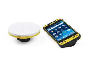
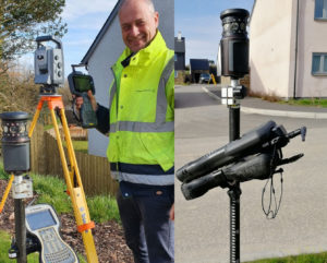
The Trimble Catalyst solution with a TDC600
The KOREC mapping team will also be available to assist Esri users with the integration of GNSS into their workflows with up to centimetre positional accuracy. Esri users will now have access to the most cost-effective method possible for cm accuracy by means of Trimble’s subscription based, low cost Catalyst solution.
To discuss all development requirements please contact KOREC Business Area Manager – Mapping & GIS, Richard Gauchwin on 07786 118436 or at richard.gauchwin@korecgroup.com
Or visit www.korecgroup.com/mapping
KOREC is delighted to announce the launch of KOREC Mapping in a move to consolidate and expand the KOREC offering of field to office data collection and handling solutions available across the UK and Ireland.
This development will see new partnerships announced as well as an expanded team of KOREC development, technical and consultancy professionals. This team will be on hand to deliver and support a full range of AgEagle and Parrot drones, mobile mapping systems and services, Trimble hardware and software and KOREC’s own in-house KOREC Capture range of field-based solutions.
KOREC is unique in offering all of these services as a one stop shop.
Bringing together over 50 years of combined mapping experience, backed up by specialist industry sector knowledge, this larger team will operate countrywide via a local network and will have strong links to both new partners (to be announced) and existing partners such as The Drone Pilot Academy, Ordnance Survey and Trimble.
KOREC Business Area Manager – Mapping & GIS, Richard Gauchwin said, “KOREC Mapping is offering a unique combination of hardware, software, industry specific knowledge and nationwide support, all from a one stop source. Our aim is to provide KOREC customers with a simple, easy to implement way in which to achieve their data capture and handling aims whether they be the digitisation of paper forms and automation of processes for greater efficiency, assistance with a new productive workflow or just a simple field data capture exercise.”
Find Out More
- Visit the KOREC Mapping homepage
- Watch our Video
ENDS
Stay tuned to find out more or for information on any of our products, please contact us.

There are seven days in a week, seven colours of the rainbow, seven seas, seven continents and now Survey Solutions has seven Trimble X7’s!
Following Survey Solutions’ recent acquisition of three further survey companies, Survey Systems, Locate Surveys and Kempston Surveys, it is now the UK’s largest engineering survey company and one that prides itself on offering ‘more than a survey’. Survey Solutions sees investment in the latest technology as an integral part of that process and has an extensive survey fleet that reflects this forward thinking approach. Most recently this has included expanding and updating its range of 3D Laser Scanners.
With nine offices – from Scotland to Somerset – company CEO James Cooper was particularly keen to ensure that his regional teams had access to a 3D Laser Scanner that would meet their demands for high quality data, ease of use and excellent productivity in the field. In upgrading the fleet’s older laser scanners, he was also keen to replace them with an instrument that all the surveyors and engineers would engage with. Their choice was the Trimble X7.

Seven scanners later, we caught up with Survey Solutions South East Director, Dave Bredin, who kindly shared his views on why the X7 has been such a popular addition to their survey fleet.
Top of Dave’s list was onsite registration. With seven X7’s in constant use, the increased efficiency on site and time saved in the office is considerable and a vital part in helping their clients meet important project deadlines. Dave estimates that on every job, office time is reduced by at least one third with the registered point cloud going straight in to drawing up.
The onsite registration also ensures that the Survey Solutions surveyors have total confidence in the data they have captured with the ability to check there and then that there are no gaps or missed areas. This reduces rework as well as time spent travelling back to a site if additional information is required. Tellingly, Dave says that it would be counter-productive to highlight a specific example of this function earning its keep because ‘… it’s every time on every job’!
Second on the list as a requirement for any laser scanner to be used nationwide was ease of use. With a large number of surveyors having access to the instruments it was vital that they could pick up the workflow quickly, with minimal training and have total confidence in their ability to collect high quality data from the off.
Dave reports that aside from the sensible pricing of the X7, there are many features that make it a perfect fit for the Survey Solutions’ fleet. These include it being easily carried in a backpack (many jobs in his SE area are undertaken in central London), the auto-calibration and self-levelling functions that ensure greater productivity on site and the Trimble RealWorks processing and analysis software that handles and combines data from different sensors. However, the real proof of an instrument’s contribution to a fleet is how it’s perceived by those who use it every day. Dave concludes, “The mark of a good piece of kit is the feedback from the surveyors who actually use it and every one of our surveyors loves it! Clearly the advancements in the Trimble X7 represent the next step in laser scanning technology and the X7’s easy to use and productive workflow is highly beneficial to both ourselves and our clients. It certainly ticks all the boxes for Survey Solutions.”

“Trimble VRS Now can be summed up in a single word – reliability.”
Neil Jefferies, Greenhatch Group Director
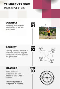

There are many reasons why KOREC customers rate Trimble’s VRS Now Service but in all the years since it’s release, the top four haven’t changed at all – accuracy, flexibility, reliability and availability – all without the need for a base station set up.
All surveyors want to maximise their time on site and need confidence in the data they are collecting and if these basic requirements are compromised, we understand that they will take fast and efficient measures to rectify any issues that could affect hard won and carefully nurtured customer relationships. That’s why many customers of VRS Now have come to us having trialled other services previously.
Trimble VRS Now subscribers range from the UK’s Police to large Civil Engineering companies, one of the UK’s busiest Ports and of course Survey Practices. We’ve rounded up four of our case studies that look at how each of these varied users have benefitted from Trimble VRS Now and just to be sure, in three cases we interviewed them when they first elected to use the service and again one year later. Each story confirms why this is a favoured solution.
Greenhatch Group
In 2015 Greenhatch Group’s 14 GNSS/GPS systems were linked to the Leica Geosystems SmartNet RTK Network via supplier approved ‘roaming’ SIMs cards. However, Greenhatch Group Director, Neil Jefferies, felt that although this combination delivered on many of the sites his surveyors worked on, he required a more reliable solution.
Highways England
On arriving at an incident, a police collision unit’s main goal is to survey the area and collect evidence as quickly and completely as possible with a view to reopening roads at the earliest opportunity. Trimble VRS Now delivers the reliability demanded in these pressurised situations.
Skanska
Under the guidance of Chief Engineering Surveyor, Mark Lawton, Skanska has been using Trimble VRS Now for over seven years and was one of our earliest users. Throughout that period, Mark reports that it has proved it’s reliability on all the road schemes it’s been used on.
Associated British Ports
Trimble VRS Now has been used to replace a base station bringing even greater coverage and improved efficiency to the Hydrographic Survey Team at ABP Southampton.
For further information visit our KOREC VRS Now page here
Or watch this excellent Explainer video
Call UK Sales: 0345 603 1214
Call Ireland Sales: 01 456 4702
For anything else, view our contact page.
It’s always interesting for us here at KOREC to see what sort of reception a new product gets and we have to say the Trimble TSC5 Android data logger has certainly had its fair share of coverage on social media since its March launch. We’ve had everything from the Trimble ‘data logger evolution’ picture to some really useful feedback and opinion from all over the world.
Rather than reproduce a Trimble press release, we’ve decided to keep things fresh with a few bullet points and hot off the press feedback from those who’ve aleady been lucky enought to get their hands on a TSC5…and they don’t all agree!
The six stand out features of the TSC5 commented on by our KOREC customers:
- A bright, anti-glare, 5-inch touchscreen for finger, stylus, or glove (Paul Williams appreciates that the sceen is bright but not blinding)
- Backlit alphanumeric keypad (Ted Harland loves the keyboard and a light coming on for the caps lock)
- Long lasting battery (Ted says he got a 9 hour day out of his TSC5 battery and still had 50% in the tank!)
- Rugged and reliable, and built to military specs and IP65 rating (You may have seen a video of the TSC5 fully immersed in a river – we don’t recommend you ever try this at home, but the TSC5 in the film emerged in full working order!)
- Android system that runs the latest Trimble Access field software and many apps including those for data storage (Jack Brittain likes the fact he no longer needs a USB)
- Light and thin form factor (Paul likes the one handed use and Ted the handy side strap)
Straight from the site – early customer feedback
“At Tri-Tech we embrace the latest technology and innovation and today I’ve been out stretching the legs of of one of our new Trimble TSC5 controllers paired with a Trimble R12i. A real step up in performance in so many ways from the much loved workhorse that is the TSC3. The TSC5 is lightweight, fast and seems very durable so far, so hopefully it will stand the test of time like the TSC3 has. It’s light but powerful and the hand strap on the side is a useful thing as is the protective ridge around the screen. They keyboard is great and I love that the light comes on with the caps lock. The fact that it’s Android is also useful because that means we have access to all the data storage apps as well such as Google Drive and Dropbox and dfx and dwg viewers. You’d need a USB C if you’re not using the data storage apps. The battery life is also impressive. I was out yesterday, used it for around 9 hours and still had 50% left in the tank!
I’m still getting used to the screen because normally I use this version of Android on a larger one so would definitely recommend the stylus, at least initially.
I liked the TSC7 and I like the TSC3 but the TSC5 is a a great bit of kit and makes good business sense as and when we upgrade. All the team are looking forward to using it. Thank you to the KOREC Group and Amanda Bradshaw for getting the kit to us so promptly – great service as always.”
Ted Harland, Director, Tri-Tech
Ted has been trialling the TSC5 with his Trimble R12i
“I used the TSC5 the other day paired with Trimble’s R12i GNSS and noted some good improvements from the previous TSC3. The new Android system is exactly what was needed, this completely eliminates our use of USB’s as we can now directly download and then upload our data directly to our Google Drive system so all our information is accessible at any time. Another good improvement is the keyboard, I like how it is set out and with the LED’s that light up when you press the caps lock for example. Although it would be nice if the screen could fill the whole area, I’m not sure if that is physically possible. Overall I think it is a great logger and is a superb upgrade from the TSC3.”
Jack Brittain, Engineering Surveyor, Tri-Tech
Jack Brittain does the unboxing!
“Finally got my hands on the new Trimble TSC5 today and….I love it!
The TSC7 is nice but I found it a bit too big for running around with. The TSC5 is thinner, lighter, very quicker and it’s easy to see what’s going on with a screen that doesn’t blind you. It also has a narrower neck so you can reach everything you need with a single hand. The TSC5 is a great addition to the range.”
Paul Williams, Director at Survey Dimensions Ltd
Paul Williams rates the form factor of the new TSC5
Did you know that the Trimble X7 3D Laser Scanner has an integrated calibration feature that offers full auto-calibration of range and angular systems in 25 seconds with no user interaction or targets?
This Trimble technology is a smart feature that monitors environmental temperature, ambient light, vibration, instrument temperature and vertical speed to take the guesswork out of your data.
With all the X7’s unique benefits, it’s possible that this one can get overlooked but in fact, when we talk to KOREC customers, they cite the low running costs and maintenance of their X7 as one of the major factors behind their purchasing decision.
Here are five reasons why auto-calibration really delivers:
- The X7 is an instrument used in many industries and not just by surveyors – auto-calibration guarantees high-quality data every time you turn on your X7 by removing concerns about whether the instrument is producing accurate scans, especially after transporting it to a project.
- Auto-calibration can save you in excess of £3k-4k a year. This was the figure calculated by Yorkshire based Centara in a recent case sudy taking into account the need to pay for the work, the transportation the instrument and its replacement with a hire instrument during the process. Instead, Centara were able to use saved cash to invest in additional equipment that they were not expecting to purchase until the next financial year.
- Auto-calibration means the X7 stays active on your fleet. With other manufacturers this process can see the instrument sent abroad for periods of up to 2-3months.
- The X7 is the first 3D laser scanner that offers smart auto-calibration and an industry-leading two-year warranty to back it up.
- Certification is provided each time the X7 auto-calibrates, Our KOREC Technical Tips video below shows exactly how it’s done.
Find Out More
- Read how the X7 and its aut0-calibration function assisted Yorkshire based Centara Ltd – Customer Story
- Find out more about the Trimble X7
- Download the Trimble whitepaper on auto-calibration
- Find out about the new mobile app for running your X7, Trimble Perspective mobile
We’re delighted to have been featured in several industry publications this month!
GeoConnexion UK (March/April 2021)
Our group Commercial Director, Mark Poveda uses his regular colum in this issue to look at a quarted of technology solutions that are helping the engineering and construction sectors stay safe and adapt to the new normal.
Civil Engineering Surveyor (February 2021)
A single click…
A 21st century workflow designed to tackle some very modern challenges
How the ECC Group tackled COVID head-on with a unique digital construction workflow designed to keep their largest projects on track, improve site productivity, cut contractor’s unseen costs and reduce the impact of COVID – all through a single click on a URL.
AEC Magazine
A problem shared
We’re back to the ECC Group and their 21st centruy workflow with this one which was featured in the March/April issue of this useful BIM technology publication.
We’re delighted to announce the launch of KOREC GEOSCHOOL, our on-line learning platform that offers a range of paid for and free of charge high quality training courses. These courses have all been designed to allow you to choose, where, when and at what pace you’d like to complete your training as well as providing lots of opportunity for questions and feedback from our qualified trainers.
It’s a tried and tested formula that we’ve based on the success of a summer training schedule that enabled companies to continue offering their surveyors and engineers personal development and technical training from the safety of their own homes.
First up for our new courses is ‘Measured Building’ a useful guide on measured building survey drawing from point cloud data using Trimble RealWorks and CAD software which will enable you to produce architect specified deliverables from point cloud data. If you have a scanner, or are planning to invest in one, or have an interest in Trimble RealWorks then this course is a must.
Expect around 6 hours of video tuition that combined with your assignments and assessments gives a course of around 2 days for you to dip into as you please. You can view the course details here.
Introductory offer: Register for our Measured Building course in March and we’ll offer 20% off.
Can it really be over 4 years since Trimble launched the SX10 Scanning Total Station? We can’t believe it either, but if there’s one thing we are sure about, it’s that the Trimble development team never stands still!
…which is why we’re delighted to announce the launch of the SX12 which brings several new features based on both customer feedback and the Trimble desire to create an instrument that combines unrivalled versatility and ease of use.
Trimble describe the SX12 as ‘engineered for every day’ and there’s no doubt that the additional functionality creates new workflows and new opportunities, especially in tunnelling, internal surveys and construction.
So what have we got that’s new?
Vivid, eye-safe laser pointer
Green and focusable, the SX12’s laser pointer yields the smallest spot size in the industry, just 3mm at 50m. This useful feature has had tremendous feedback from early testers, including KOREC customers, who report that it is exceptionally bright making it ideal for internal buildings, tunnels, mines and construction sites.
Improved camera system
The SX12 now offers an 8.1 MP resolution camera (compared to the SX10’s 5 MP) and a 107x zoom (compared to the SX10’s 84x). This means clearer, more detailed pictures of far away objects resulting in improved aiming, more vivid colours and of course, less image noise in low-light situations.
The SX12 retains all the other stand out features of the SX10 and that includes ease of use, a short learning curve and versatility which means it could easily become the hardest working instrument on your fleet.
To celebrate the release of the SX12, we’re running a little promotion to allow a lucky winner of our prize draw to meet the new kid on the block before anyone else! Just follow the link here to enter your contact details and you could benefit from a week’s FREE hire of the SX12 and get your hands on it before anyone else!
Closing date – 19th March 2021.

Call UK Sales: 0345 603 1214
Call Ireland Sales: 01 456 4702
For anything else, view our contact page.
KOREC and Drone Pilot Academy celebrate 5 years of success with an extended partnership bringing new pilot benefits.
- DPA now an approved partner for drone demonstrations.
- Increased dissemination of useful information through webinars and social media.
- Faster access to new industry releases.
- Competitive package pricing on drone purchase, product and CAA training.
KOREC is delighted to announce that following a productive 5 years with Drone Pilot Academy (DPA), which has seen hundreds of drone pilots successfully undertake consecutive flight training and Civil Aviation Authority (CAA) accredited pilot training courses, the partnership has been extended to bring additional benefits for existing and prospective drone pilots. These include:
- DPA will now be KOREC’s approved partner for the demonstration of all KOREC supplied senseFly and Parrot drones. This will ensure a fast turnaround for the viewing and testing of the latest drone technology and an even more streamlined approach to combined drone purchase and training.
- Increased collaboration for the sharing of news, regulation changes, tips and updates through social media and webinars. For example, you can now view a live stream from KOREC supplied drones using Microsoft Teams …ideal for fast decision making, inspections and progress reports, all viewed COVID safe from a laptop. This is just one of the ‘Know Hows’ to be covered in the KOREC/DPA webinar on Monday 22nd February along with an analysis of new European regulations, A2 drone categories and new products.
- Fast access to new industry releases such as the ANAFI USA with its thermal camera and 32x zoom and senseFly’s eBee Geo, an affordable fixed-wing mapping drone.
- Collaboration on drone price and training prices for the most cost-effective packages.
Mark Poveda -KOREC Group Commercial Director said “This partnership enables KOREC to offer the most cost saving, robust solutions to the professional commercial drone industry in the UK. DPA staff deservedly have a great reputation in the industry – instructors are ex-military aviators and surveyors with a wealth of experience in training and instruction and also have factory training on our drones so they know the systems inside out.”
James Ixer – Managing Director of DPA said “This has really been a fantastic journey over the last 5 years. Our instructors have earnt their credibility within the sector through their qualifications as land and building surveyors and unrivalled experience using drones in the industry, knowledge that is extremely useful when advising customers on how to integrate this fantastic technology into existing workflows.”
One graduate of the academy, Owner and Managing Director Lee Husk, of PDS Ltd testifies “It is a winning combination between the two companies as you have a one stop shop to get you from complete novice to operating sophisticated drones in no time at all. We have always believed in investing in the latest technology and operate both the SenseFly eBee X and the Parrot ANAFI Without a shadow of a doubt our end clients never fail to be impressed by the outputs these drones can achieve.
Read a case study on how Lee Husk used the Parrot ANAFI here.
Join our webinar with Drone Pilot Academy on Monday 22nd February, click here.

SeneseFly’s eBee Geo (left) and Parrot’s ANAFI USA (right)