“Trimble VRS Now can be summed up in a single word – reliability.”
Neil Jefferies, Greenhatch Group Director
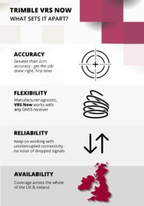
There are many reasons why KOREC customers rate Trimble’s VRS Now Service but in all the years since it’s release, the top four haven’t changed at all – accuracy, flexibility, reliability and availability – all without the need for a base station set up.
All surveyors want to maximise their time on site and need confidence in the data they are collecting and if these basic requirements are compromised, we understand that they will take fast and efficient measures to rectify any issues that could affect hard won and carefully nurtured customer relationships. That’s why many customers of VRS Now have come to us having trialled other services previously.
Trimble VRS Now subscribers range from the UK’s Police to large Civil Engineering companies, one of the UK’s busiest Ports and of course Survey Practices. We’ve rounded up four of our case studies that look at how each of these varied users have benefitted from Trimble VRS Now and just to be sure, in three cases we interviewed them when they first elected to use the service and again one year later. Each story confirms why this is a favoured solution.
Greenhatch Group
In 2015 Greenhatch Group’s 14 GNSS/GPS systems were linked to the Leica Geosystems SmartNet RTK Network via supplier approved ‘roaming’ SIMs cards. However, Greenhatch Group Director, Neil Jefferies, felt that although this combination delivered on many of the sites his surveyors worked on, he required a more reliable solution.
Highways England
On arriving at an incident, a police collision unit’s main goal is to survey the area and collect evidence as quickly and completely as possible with a view to reopening roads at the earliest opportunity. Trimble VRS Now delivers the reliability demanded in these pressurised situations.
Skanska
Under the guidance of Chief Engineering Surveyor, Mark Lawton, Skanska has been using Trimble VRS Now for over seven years and was one of our earliest users. Throughout that period, Mark reports that it has proved it’s reliability on all the road schemes it’s been used on.
Associated British Ports
Trimble VRS Now has been used to replace a base station bringing even greater coverage and improved efficiency to the Hydrographic Survey Team at ABP Southampton.
For further information visit our KOREC VRS Now page here
Or watch this excellent Explainer video
Call UK Sales: 0345 603 1214
Call Ireland Sales: 01 456 4702
For anything else, view our contact page.

Fred Astaire and Ginger Rogers, Tom and Jerry, Thelma and Louise…we love a good double act, especially when they really complement each other, and that’s why we’ve introduced this Trimble R8 and VRS Now offer!
On the one hand we have the R8, Trimble’s flexible and scaleable GNSS that allows you to choose the configuration level that suits you best – post-processing, base, rover, or a combination of base and rover functionality. After you’ve selected your configuration, additional options can be added as your business grows!
Find all the Trimble R8 facts and figures here
And on the other hand, Trimble VRS Now, a real-time correction service that has been described as ‘unbelievably reliable’ by KOREC customers more times than we’ve had hot dinners. So much so that it’s the chosen service for Highways England for use by the police, primarily for collision scene investigation. And did we mention that KOREC customers have switched their GNSS fleet to Trimble just to get their hands on this winning combination?
Here are a few of our VRS Now case studies:
Highways England renews Trimble VRS Now license with KOREC
Why Greenhatch switched to VRS Now
Team SUMO chooses a perfect combination in the R8 and VRS Now!
Skanska’s Trimble VRS now journey – 7 years on
 Those mapping golf courses, especially for TV coverage of events, choose to use a Trimble Geo7x with CenterPoint RTX for mapping the outlines of greens and bunkers. This 4cm positioning service eliminates a ‘hexagonal’ effect when mapping these areas instead producing a smooth outline.
For Mark Humphrey, Director of L&SS and the first KOREC customer to invest in Trimble’s R10 GNSS, xFill has proved particularly useful. At the time of purchase Mark was working as an ‘on call’ surveyor on the £1.5bn DP world owned London Gateway project. He couldn’t afford to have down time and cited one of the most productive benefits of the R10 as being its high accuracy (used in conjunction with Trimble VRS Now) and its xFill technology which allowed him to survey continuously, even when the size of stockpiles interfered with the radio link to the base station. A fully case study can be read here.
Oxford University has been working in Greece using a Trimble R10 GNSS in conjunction with CenterPoint RTX for archaeology surveys. It’s proved a great back up when they are out of their base’s range.
The RSPB favours a Trimble R1 with ViewPoint RTK for affordable 1 metre accuracy on a project in the South Atlantic.
The Highways Agency has 100+ Trimble VRS Now licenses delivering centimetre accuracy on demand for the Police to use their GNSS receivers easily and accurately to survey road incidents as quickly as possible to reduce congestion.
Selecting the best positioning option for your site.
Our quick guide to the ins and outs of KOREC’s positioning services including Trimble VRS Now, Trimble RTX and Trimble xFill
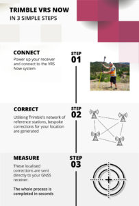
Trimble VRS Now
 In short: Trimble VRS Now is a network RTK service that provides users with instant access to RTK corrections. Using precise data supplied by a dense network of reference stations, VRS Now can deliver centimetre level RTK anywhere in the network, customised for each rover’s exact location. It’s widely used by KOREC customers and much praised for its reliability.
Suitable for: Any site engineer who requires a super reliable positioning service with fast initialisation times and accuracies of 25mm. Especially useful for engineers who have to visit several different sites during a day or those who work on long linear sites.
Trimble VRS Now is suitable for use with Trimble GNSS rovers and also offers clear benefits over other area network solutions, even when used with 3rd party receivers.
Cost: Subscription based service
Further information: A handy run down on VRS Now FAQs can be read here.
Trimble RTX
 In short: RTX is a new positioning technology that brings together the advantages of new techniques that do not require a local reference station network or a mobile phone connection, whilst providing the productivity of RTK positioning. Four options are available with signals received either via satellite or via IP/cellular.
Suitable for: Any site where mobile phone coverage is non-existent or compromised and applications where high accuracy and fast initialisation aren’t priorities.
- CenterPoint RTX – 4 cm accuracy. CenterPoint RTXisTrimble RTX’s premier correction service converging to full accuracy in 1-5 minutes in select regions (including the UK and Ireland), and less than 30 minutes worldwide. Compatible with the Trimble NetR9 Geospatial, Trimble R10, Trimble R2, Trimble R9s GNSS Receiver and Trimble Geo7X handheld. Subscription service
- FieldPoint RTX – decimetre accuracy. A mid-level option compatible with the Trimble R2 GNSS receiver and Trimble Geo 7X. Subscription service
- RangePoint RTX – sub 50 cm accuracy. An affordable correction service compatible with the Trimble Geo7X handheld and Trimble R2. Subscription service
- ViewPoint RTX – 1 metre accuracy. Affordable entry level accuracy compatible with the Trimble Geo7X handheld, Trimble R1 and Trimble R2. Subscription service
Cost: CenterPoint, FieldPoint, RangePoint and ViewPoint are subscription based services.
Further information: Full information on Trimble’s RTX Positioning Services can be found here.
Trimble xFill

In short: The jewel in the RTX portfolio is Trimble xFill! A technology that’s always there when you need it. Trimble xFill, powered by Trimble RTX, technology, runs seamlessly in the background, automatically bridging the gap if an RTK or VRS correction source is interrupted due to cellular signal disruption or loss of radio line of sight, allowing you to maintain centimetre-level corrections.
Suitable for: All surveyors who wish to remain productive on sites where their signal might be compromised by tree canopy, stockpiles etc
Cost: Trimble xFill continues to be free for the first 5 minutes of use on all compatible receivers with no degradation of accuracy. Additionally it can also now be used indefinitely beyond 5 minutes on the Trimble R10 and NetR9 Geospatial receivers with a valid CenterPoint RTX subscription.
Further information: Full information on Trimble xFill can be found here.
Why Greenhatch Group switched to Trimble VRS Now

Greenhatch surveyor Scott Smith with Trimble R10
Surveyors want reliable data. They also want to maximise their time on site. When these basic requirements are compromised, businesses will take fast and efficient measures to rectify any issues that could affect hard won and carefully nurtured customer relationships.
For Greenhatch Group Ltd, this entailed the introduction of a completely new positioning correction service for use with their 14 GNSS/GPS systems when their old set up failed to deliver the quality of data, reliability and peace of mind that they required.
Greenhatch Group can trace its origins back to an early offering of surveying services over 35 years ago and today operates through a national network of three regional offices. Employing over 70 staff, the company has expanded in the last few years to offer a wide range of surveying services from topo and measured building surveys to specialist undertakings such as 3D laser scanning, BIM/REVIT Models, bathymetric surveys and aerial drone surveys.
With the core of its business being topographical and measured building surveys, the company depends upon the reliable performance of its optical and GPS/GNSS instrumentation and was therefore quick to react when the performance of its existing RTK broadcast correction service aroused concerns.
Analysing the problem
In 2015 Greenhatch Group’s 14 GNSS/GPS systems were linked to the Leica Geosystems SmartNet RTK Network via supplier approved ‘roaming’ SIMs cards licensed under a 3 year subscription deal. Whilst Greenhatch Group Director Neil Jefferies felt that this solution delivered on many of the sites his surveyors visited, he was concerned that, overall, the combination of the service provided, equipment and SI card was unreliable. Coordinate quality wasn’t sufficiently achieved on a number of sites up and down the country and the amount of lost time due to broken connections was immeasurable. In short, Neil felt that there was considerable room for improvement and that the Group’s correction service should be providing them with more reliable returns.
Trialling solutions…
Greenhatch Group tried various solutions to improve its operational times with the RTK Network. These included upgrading to private APN (Access Point Name) SIM cards and trying SIM cards from different service providers, even to the extent of having a wallet containing separate O2, Vodafone, EE and 3 pay as you go SIM cards for each GPS system. Different combinations of GNSS models and receivers were also tried to see if the loss of connection was a hardware problem and this was supplemented by Greenhatch surveyors keeping a log of each lost/broken connection, recording both time and location.
Only the multi SIM card approach brought any improvement but with that improvement came a set of new problems. Constantly switching SIM cards and settings became tiresome with less experienced users becoming mired in a world of menus and settings and the GNSS rovers were suffering from repeated openings and closings to insert the cards.
…and finding the answer
Greenhatch came upon its solution by chance when a KOREC sales consultant was visiting during one of the surveyor’s – by now daily – reports of a failed RTK connection. The KOREC consultant was able to talk Neil through the benefits of VRS Now, Trimble’s RTK subscription service, and within 48 hours had arranged the loan of a SIM card providing Greenhatch with immediate access.
A GNSS rover was selected and a Greenhatch surveyor sent out as a ‘guinea pig’ to trial VRS Now whilst Greenhatch’s management prepared to field his calls and relay any problems back to KOREC.
“We didn’t receive a single call,” reports Greenhatch director Neil Jefferies. “We later saw our test surveyor in the office and he said that he’d had no issues at all and connection had been good throughout the trial. In fact, his only complaint was that his legs hurt from walking all day!”
To further assess the situation, KOREC additionally loaned Greenhatch a Trimble R10 rover with VRS Now to compare with their existing Leica GNSS also with VRS Now. Following this trial two R10s were purchased along with 15 VRS Now licenses to cover the company’s entire GPS/GNSS fleet.
Neil concludes, “Previously our surveyors were getting frustrated on site. They simply wanted to complete jobs and get home but with the old system they were never sure whether it was going to be a good day or a bad one. Since switching to VRS Now, the number of calls from site surveyors saying they are not going to finish projects, or that they need to return due to GPS issues, has reduced to a level where it is very rare to get one at all. This has also minimised the time technical staff and management have to spend responding to their calls allowing them to concentrate on other parts of the business instead. There is no doubt that for Greenhatch, the benefits of Trimble VRS now can be summed up in a single word – reliability.”
Case study
Greenhatch Group director, Neil Jeffries, reports that a multi-acre greenfield site was recently surveyed by Greenhatch. Traditionally the survey team would use a total station to survey hard detail and boundaries and use GNSS units to infill levels within the fields.
Neil has a general idea of how many acres per day are achievable by a surveyor using a GNSS unit and this includes some down time to cover connection issues. Upon surveying the site with units connected to VRS Now, the systems completed the work 10-20% faster than anticipated compared to similar sites undertaken in the past with the original equipment set up. This project was valued at around £15,000 and Neil affirms that thanks to the reliability and efficiency of the Trimble VRS Now service, cost savings can be calculated at £2,500.
Andrew Beckerson, KOREC’s Director of Business Development comments “Greenhatch’s experience with Trimble VRS Now echoes what many users have found, reliable real-time GNSS correction data will increase your profitability, proving once again that ‘not all correction services are the same.’

VRS Now fact box:
- Availability: Unites States, Europe and Australia
- High Accuracy: Provides < 2 cm (1″) accuracy*
- Ideal for a variety of industries needing high precision including survey and construction, mapping and GIS, cadastral, utilities, transportation and areas having good cellular coverage
- Instant Initialization: Start working immediately under optimal conditions**
- Multi-constellation support: GPS and GLONASS enabled
- More uptime: Built-in redundancy to ensure connectivity, consistency and quality
- No base station required: No need to worry about losing radio signal reception since a base station is not needed for Trimble VRS Now based correction services
- Ease of Use: Online self-service portal to activate subscriptions.
* All horizontal accuracy specifications are based on in-field performance 95% of the time.
** Receiver initialization time varies based on GNSS constellation health, level of multipath, and proximity to obstructions such as large trees and buildings.