Last month, we calculated that the cost of wet weather due to lost productivity, repeat visits and wasted trips could be in the region of £20,000 per year for the ‘average’ land surveying practice*.
Not all brands of surveying equipment work well in the rain, and with the UK averaging 161 days of wet weather a year, that’s a lot of wasted journeys and repeat visits. And if there’s one thing we hate at KOREC, it’s waste and inefficiency.
So, with this is mind, we decided to do something rather bold. We teamed up with ATR Shield to give away 50 total station shields, free of charge, to the 50 surveyors who gave us their most convincing reason for needing one.

And boy did you deliver! We received over 150 requests from across the nations. From the tip of Cornwall to the top of Ireland, from the Welsh valleys to Brixton – and your reasons made for fascinating reading. Here’s just a selection of your comments for why you desperately need a shield for your soggy total station;

Trimble to the Rescue!
At KOREC, we’re all about empowering our customers with the solutions they need to get the job done, with the minimum of fuss. After all, the slogan ‘Do It Once, Do It Right, Do It Now’ was a former company motto of ours!
That’s why we are so proud to provide solutions that are built for all weather conditions – come rain, shine – or even sleet and snow!
Trimble S Series total stations are world renowned for their reliability, their accuracy, and their robust nature in all weather conditions – no shields needed for this one!
Right now, we are offering over 20% off the Trimble S5, along with all the kit you need;
- Trimble TSC5 controller
- Access software (General Surveyor)
- Trimble Sentinel track & retrieve app
- Prism
- Telescopic pole
- Tripod
If you’d like to find out more about this bundle, contact your local KOREC consultant, or use the details below;
Call UK Sales: 0345 603 1214
Call Ireland Sales: 01 456 4702
For anything else, view our contact page.
*See previous blog ‘Don’t Let Rain Stop Play’ for full breakdown of the numbers
We’ve all heard of the saying ‘a little bit of rain won’t hurt’, but when it comes to your land survey kit, is it true?
Being the stats nerds that we are, we decided to run the numbers to see how much your soggy survey kit is really costing you.
Picture the scene. You’re out on a land survey or set out job with your total station, when the skies darken, the wind picks up, and the heavens open. You’ve got two choices – you fashion a DIY cover out of spare bits and bobs, or, if you’re like us, you make a dash for the van, grab a coffee to keep warm and dry, and wait for the rains to subside.
If we lived in the Med this may not be such an issue, but here in the UK it rains an average of 161 days of the year – that’s almost half of the time!
That’s a lot of days wasted sitting waiting for the skies to clear – or risking damaging kit that you know isn’t too fond of water ingress. We’ve even heard tales of folk desperately drying off their kit with hair dryers in the back of the van!
Running the Numbers
So, we decided to run the numbers to see exactly how much all of this wasted time could be costing you.
Over the last two decades, the UK has averaged 161 rainy days each year, 44% of the days. When it comes to working days (assuming you’re not a workaholic and enjoy the odd weekend and holiday each year) there’s roughly 240 days of working per year, which means a potential for 106 ‘rainy’ working days.
With the average land surveyor costing around £120 a day*, and assuming that on the rainiest of days you’re losing around 3 hours of productive time packing away kit, returning to the van, sitting in the van (not to mention getting the hair dryer out) we reckon the daily loss is around £48 per rainy day.
But, it gets worse. That ‘lost’ 3 hours of work still needs to be completed on a dry day, meaning another trip to site, another mileage expense, and another £48 gone. This second trip to site also means that other survey work, for other clients, has to either be rearranged, pushed back – or worst of all, lost.
All in all, we reckon that ‘bit of rain’ could be costing you the best part of £10,000 per surveyor over the course of a year!

Of course, the financial cost is just one element.
Every time rain stops survey, it shortens the timescale for getting the job done. Not only does this add time pressure to the job, it cause severe reputational damage to your business, straining relations with your client, as well as threatening your competitive edge when it comes to bidding for other work.
Dry your Eyes
If those figures brought a tear to your eye, don’t be concerned – there is another way!
We’ve put together the #WinterReady land survey package which has everything you need to get your survey work completed – come rain or shine.
Featuring the robust Trimble S5 with active tracking, the new TSC5 controller, a license for Trimble Access (General Survey) and more, our #WinterReady bundle gives you all you need to keep on working thru’ the wind and rain.

If you’d like to find out more about this bundle, contact your local KOREC consultant, or use the details below;
Call UK Sales: 0345 603 1214
Call Ireland Sales: 01 456 4702
For anything else, view our contact page.
*Based on figures from Reed.co.uk, assuming an annual salary of £30,518 and a working week of 37.5 hours, we obtained a figure of approximately £117 per day for a land surveyor, or £16 per hour.
Trimble Sync Manager (TSM) is a helpful tool for surveyors looking to seamlessly manage data between office and field via the cloud.
Jobs created in Trimble Business Center can be issued anywhere in the world at the click of a button. Part of the Trimble survey workflow, tasks are delivered to surveyors via Trimble Access and can be fully configured to include linked files such as DXF maps and CSV which means field staff can get to work immediately.
The two-way sync also allows completed survey jobs to be uploaded to the cloud and downloaded back at the office straight away.
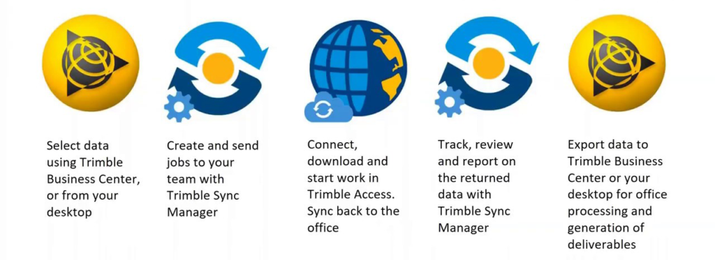
Using TSM is a simple process:
- Select data using Trimble Business Center, or from your desktop
- Create and send jobs to your team with Trimble Sync Manager
- Connect, download and start work in Trimble Access
- Sync back to the office
Track, review and report on the returned data with Trimble Sync Manager
Export data to Trimble Business Center or your desktop for office processing and generation of deliverables
To continue using Trimble Connect to sync data with Trimble Access, please upgrade to the latest version of Trimble Sync Manager (1.4.63) on your PC. An upgrade to Trimble Access version 20201.10 or later will also be required if you aren’t already running this version of the field controller software. If you are syncing data with Trimble Business Center then TBC v5.5 onwards is required.
Trimble Sync Manager will automatically update itself when run. Trimble Access requires an in-date warranty to upgrade to the latest version, which is done via Trimble Installation Manager.
Further reading
Trimble Sync Manager in two minutes on YouTube: https://youtu.be/RAlZZ21hwKw
For a more detailed review, follow this link: https://youtu.be/ot_Y8J4J3hE
Full details on the Trimble Geospatial website: https://geospatial.trimble.com/sync-manager
If you need any assistance with updating or installing any of these software packages, please contact support@korecgroup.com or call 0151 931 670.
3 old total stations bound for the skip at Malcolm Hughes Land Surveyors (MHLS) in Swansea have been brought back to life and donated to the National Coastwatch Institution (NCI) to help their monitoring of shipping off the North Cornish Coast. The NCI is a voluntary organisation keeping a visual watch along UK shores and when ships get into trouble, they are there to alert HM Coastguard and direct the appropriate rescue services.
Last summer Volunteer Watch-keeper Chris Angove approached MHLS Land Surveyor Jon Grigg over a drink asking how more accurate bearings and distances could be obtained from their St Agnes Head station. Jon was able to locate 3 non-working instruments (2 Trimbles and a Geodimeter 600) from Swansea and gained permission to try to get them repaired.
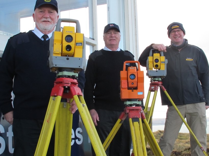
Jon Grigg (MHLS Swansea) presents the 3 instruments to Jim Jefferis and Chris Angove at the NCI station St Agnes Head
In October Jon was able to arrange a free repair, service and upgrade for all 3 instruments through KOREC Group – who’s Engineer John Salter even remembered working on that actual Geodimeter 20 years ago! John, along with help from other members of the KOREC workshop team, gave up his lunchtimes to calibrate, repair and check over the instruments before passing them to Jon for use.
The NCI will be using the instruments to measure a vertical angle difference from the horizon to a ship at sea – this is used to calculate a very accurate distance (using expanded Bowditch chart calculations) as well as an accurate bearing, which can then be relayed to the emergency services to quickly reach any vessel in distress. With a visible horizon of over 20 miles, their normal estimates can sometimes have an error of several miles. Using these instruments should see any errors reduced to less than a few hundred metres which could be the difference between life and death in a rescue scenario.

A watchkeeper using a Trimble device
In mid-January the NCI station went “live” with the first of the instruments and their band of volunteers are being trained in their use. This new life given to old disused instruments could well assist in saving lives at sea in the years to come.
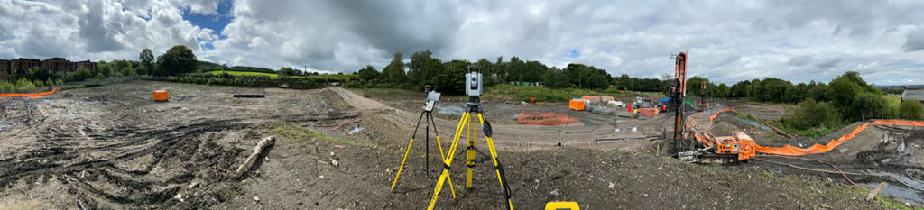
Total Station. It’s not likely to be the most exciting piece of kit in your toolbox – but as these happy customers attest, your Trimble total station might just be your most faithful survey sidekick.
The name may not set your pulse racing, but when everything else seems so uncertain at the moment, isn’t it reassuring to just have a piece of kit that performs, day in, day out, in all weathers?
“We’ve put our Trimble S7 through a lot, from surveying to scanning to setting out, and it’s always lived up to our expectations even in torrential rain, to put things into a better perspective, we would be broken by the cold and rain but the S7 would still be going!”
Ionut Pascuta, Civil Engineer, Lay of Land
Lay of Land put their Trimble total station to the test on a daily basis, in all weathers
The Reliability you Need – projects large & small
“Our Trimble S5 is used for surveying and setting out on both small and large scale projects. It has yet to let us down yet even in the unpredictable Irish weather”
Gary O’Hare, Mourne Air Surveys

“Robust, reliable and consistent, hail or shine, our Trimble S8 brings the reliability we need for reducing risk for our clients on complex engineering projects”
John McGoey, CEO, ECC Group
Total Security with Locate 2 Protect
As well as delivering robust & reliable performance on the daily, all Trimble S-Series total stations are available with Locate to Protect (L2P) tracking technology – so in the worst case scenario, if your kit is lost or stolen, you can track and locate it, in real time, to aid a speedy recovery – sometimes as fast as 30 minutes.
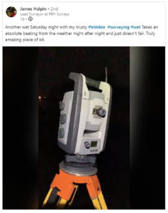
PBH Surveys utilise their S-Series in all weathers – day & night!
And this month, we’re including L2P cover, alongside a ream of other benefits, for 3 years, when you buy your own Trimble total station from us.
That’s 3 years peace of mind, including no calibration fees, no repair or update costs*, no support costs, and 5% off total station hire costs if you need a replacement unit – until 2023.
We call it, the Peace of Mind package.
Find out More
Give us a call;
UK 0345 603 1214
Ireland +353 (0) 1 456 4702
or download our PDF with the offer details?
*refers to non-damage related repairs
Furloughs. Lockdowns. Travel Restrictions. We’re well aware that 2020 has been rather…unpredictable.
And while your business doesn’t like uncertainty, we also know that in order to remain competitive and productive, you want access to the best survey equipment there is.
That’s why we decided to build a total station package that gives you reassurance and certainly for the coming years, whilst providing you with the most reliable & rugged total stations on the market today.
We call it, the Total Peace of Mind package.
What’s the deal?
Here’s our offer;
Purchase any of the Trimble S-Series total stations (that’s the S5, S7, or S9) before the end of November, and we’ll give you a 3-year subscription to the KOREC Total Care Package, at no extra cost.
KOREC Total Care Package
- Annual unit calibration
- Non-damage related repairs
- Locate 2 Protect coverage, so you can track your equipment if lost or stolen
- Software & Firmware updates for Trimble Access & Robotic
- 5% off hire costs for a replacement unit, if required
- Dedicated specialist technical phone support
All included, for 3 years.
Just a little something from us, to make the future a little less uncertain.
To find out more, why not Contact Us today?
Or find out more about the kit, by visiting our Total Station page.

This September marks something of a milestone for Debbie Vincent, our Operations Manager (Huntingdon branch) – 10 years at KOREC.
Many UK KOREC customers may be familiar with Debbie and her team, but to mark her decade with the company, we asked Debbie to look back over her years working with us. Here’s what she had to say;
So, it’s been a journey, let me begin,
Back in July 2010 I was made redundant from a position I had held for almost 15 years, sadly the company was no longer and I found myself in the big wide world along with many others looking for work. I just happened to bump in to a friend who said ‘they are looking for admin staff where I work I am sure you would fit in’ – this was the start of my journey. I started with KOREC on the 8th September 2010.
Covering maternity leave for the admin team working for the Machine Control side of the business – I loved this as it was similar to what I had come from, the majority of machine control kit had to be installed so you had a number of factors to consider on every sale. At that time we covered the three operational roles which included sales, workshop and hire for the product area you were working in.
Debbie with some of her team in Huntingdon

After a couple of years a role became available in the hire department which I was fortunate enough to manage. This role gave me a huge insight into the products, which has stood me in good stead throughout my career here. Hire is extremely reactive so you have to be able to juggle a number of balls without letting any drop to the ground!
From the hire role I was promoted to Operations Manager at the Huntingdon depot something I continue to do to this day – this role allows me to oversee the day to day running of the depot whilst ensuring our clients get the best possible service.
How time changes things, I have seen the TSC2 now replaced by the TSC7, R4 GPS units now replaced with R12’s, and now a unit that calibrates itself, nothing stays the same for long in this fast paced working environment!
But, I can honestly say I have truly enjoyed my time at KOREC, the people I work with and have met along the way have been truly wonderful 😊
From all of us at KOREC, thank you Debbie for your decade of dedication!
Find out more about our world-class workshops & facilities on our Service page.
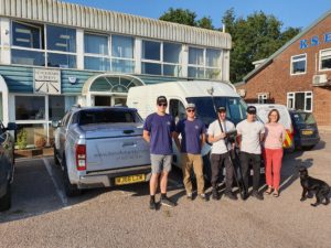
The Benchmark Surveys team; Josh Rogers, Sebastian Glover, James Richards, Sebastian Richards, Helen Richards & Dennis the dog
It’s been just 3 weeks since the R12i was launched to the world on 1st September.
But already Benchmark Surveys of Exeter have taken delivery of their new GNSS solution – the very first to be sold in the UK.
The team took part in trials with the new unit at the end of August, and it’s fair to say, they were blown away by the results they saw – watch the video below to see what we mean!
To see the R12i for yourself, take a look on the product page and sign yourself up for a demo;
Or find out more about Benchmark’s work;
https://www.benchmarksurveys.co.uk/
The story of 2 customers
Cast your mind back to September 2019, when trade events were in full swing. At INTERGEO, Trimble announced the launch of a new type of laser scanner – one that delivers powerful performance, with simple operation.
The X7 promised fast, simple and accurate laser scan results, but 1 year on, does the product live up to the hype?
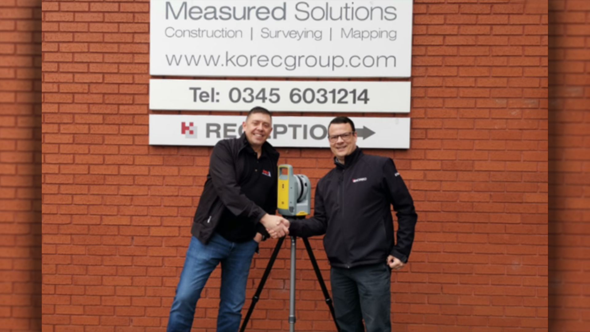
Barry Burrows takes delivery of his X7 from KOREC’s Barry Monk
Barry Burrows of BB Solutions didn’t have to think twice before making the purchase and became the first customer in the UK to own an X7. Since then Barry has put his new kit to the test on multiple occasions and has found that it was the perfect piece of kit for him and his business.
“I watched a few product videos on YouTube, read some online reviews and after about 15 minutes I knew that this was the right kit for me and my business.”
“With that scanner the amount of data collected was huge – I would easily spend 6-8 hours back at the office just processing the data, a lot of which was only needed for registration and would then be discarded”
In August, Survey Solutions took delivery of four brand new Trimble X7 laser scanners to use across their UK offices. The ongoing investment in the latest tech will insure that they continue to supply their clients with the best possible data as well as meeting important project deadlines.
“Laser scanning is a huge part of our measured building service and the new scanners further help our teams carry out their on-site survey and office processing.”
The Trimble X7 has most definitely lived up to expectations and gone above and beyond in just 365 days and we can’t wait to see what the X7 will get up to next.
To see for yourself just what the X7 can do, click here
This week saw the launch of the next level GNSS solution from Trimble – the R12i.
Featuring robust IMU tilt-compensation via their patented TIP (Trimble Inertial Platform) technology, you can forget about levelling the pole and focus on collecting points, faster, safer and easier.
Utilising an angled pole allows you to obtain previously impossible or hazardous points – such as corners of buildings, tree bases and by rivers/watercourses.
With no time wasted calibrating or levelling, you can be much more rapid when collecting points – check out the video here to see how the R12i compares!
We are hosting a special R12i webinar on the 10th, to give you the complete lowdown on the new features, the benefits to your business, and multiple applications. Sign yourself up;