KOREC is delighted to announce that following a successful tender, it is supplying Ordnance Survey (OS) with one hundred and eighty Trimble R980 GNSS Receivers. These receivers will be supported by KOREC for the duration of the five-year contract.
Download a PDF of the press release here
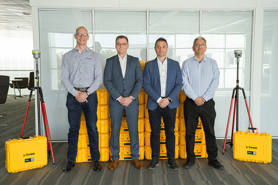
From left to right: Chris Harris (Channel Sales Manager, Field Systems EMEA, Trimble), Michael McEvoy (Principal Production Consultant, Ordnance Survey), Mark Poveda (Managing Director – UK & Ireland, KOREC Group) and Cesar Almeida (Senior Applications Engineer, KOREC Group)
The OS move to Trimble UK distributor, KOREC, has been based on both the advanced performance and productivity that the top-tier Trimble R980 Receivers can deliver, and their easy integration with OS’s existing data collection and handling software, the Esri suite of ArcGIS products.
The R980 Receivers brings together several top Trimble GNSS technologies and are particularly suitable for OS through features such as Trimble CenterPoint® RTX corrections for RTK level accuracy worldwide delivered via satellite or internet, without the need for a local base station or VRS network.
Mark Poveda, Managing Director – UK & Ireland, KOREC Group said:
“We’re extremely proud to be supporting Ordnance Survey with the supply of Trimble R980 GNSS Receivers following a successful tender. This significant contract reflects not only the performance and reliability of Trimble’s leading-edge GNSS technology, but also the confidence that OS has placed in KOREC as a long-term technology partner. We look forward to supporting OS over the next five years and ensuring their teams have the tools they need to maintain the highest mapping standards.”
Michael McEvoy, Principal Production Consultant, Ordnance Survey said:
“Ordnance Survey is pivotal in supporting the government, businesses, and individuals by maintaining and updating the digital master map of Britain with 20,000 changes a day. Our field surveyors therefore need a modern, robust, and accurate GNSS system to assist with the capture of our data which will serve them effectively now and into the future. The KOREC Group has provided OS with a great solution that integrates into our existing production environment. It will also enable our surveyors to use new technologies and capture tools to improve efficiency, whilst other features will enable work in remote areas, reliably and to high precision.”
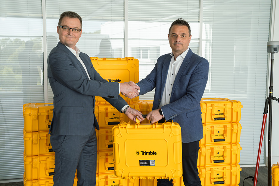
From left to right: Michael McEvoy (Principal Production Consultant, Ordnance Survey) and Mark Poveda (Managing Director – UK & Ireland, KOREC Group)
About KOREC Group
KOREC’s mission is to empower you to measure, map and manage the natural and built environment.
Combining industry knowledge, with intuitive software, and world-leading positioning technology, KOREC transforms your operations bringing certainty to your decision making.
About Ordnance Survey
Ordnance Survey (OS) is Great Britain’s national mapping service. We carry out the official surveying of Great Britain (GB), providing the most accurate and up-to-date geographic data, relied on by government, business, and individuals.
Congratulations to Atkins, the company that has been appointed by the government’s Geospatial Commission to help create a digital map of underground pipes and cables throughout the UK.
The map will be known as the National Underground Asset Register (NUAR) and is being developed by Atkins alongside mapping agency Ordnance Survey and geospatial data management leaders 1Spatial.
Designed to revolutionise construction and development across the country, the Geospatial Commission NUAR map release states that, “The economic cost of accidental strikes on underground pipes and cables is estimated to be £2.4 billion per year and one cause is inaccurate information on the location of buried assets. Once operational, NUAR is expected to deliver around £350 million per year in benefits by avoiding accidental asset strikes, improving the efficiency of works and better data sharing.”
The project is about to enter its build stage, a process estimated to run for three years. This is a large and ambitious undertaking, but the geospatial industry is highly progressive when it comes to the development and adoption of technology for field data capture and verification and the NUAR project will no doubt make excellent use of these developments.
Here at KOREC we can’t help but make three suggestions for technology that could be beneficial on a project of this nature:
Mobile Mapping + GPR Survey
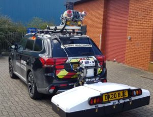
The KOREC Professional Services team has just completed a roads project that saw them carry out a Trimble MX9 vehicle mounted mobile mapping survey at the same time as an underground mapping survey using Ground Penetrating Radar (GPR). This dual-purpose survey was completed with a single pass (reducing emissions and keeping boots off the tarmac) and produced a data set suitable for many applications from asset management to road conditions surveys to pre site risk analysis.
The Trimble® MX50, offered for sale by KOREC, is a practical field-to-finish mobile mapping solution for asset management, mapping, and road maintenance. The system delivers a very accurate point cloud of the environment along with complementary immersive imagery providing substantial gains in productivity in areas such highway management, utilities and local government.
Augmented reality

Imagine if you could see things that are hidden or that don’t actually exist yet. Trimble® SiteVision™ brings geospatial data to life so you can easily visualise, explore and understand complex information with unrivalled centimetre accuracy, right from your mobile device.
Ideal for use before and after in an application such as the NUAR project, SiteVision is proven technology used for the visualisation of underground assets by organisations such as Balfour Beatty Plc, O’Brien Contractors and the A14 Integrated Delivery Team.

Trimble SiteVision couldn’t’ be easier to use and is highly portable for use on site.
Centimetre accurate, low-cost positioning for large workforces
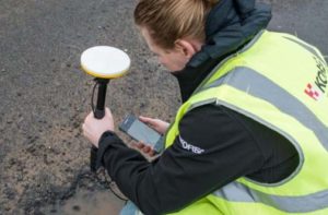
If you have a large workforce that requires centimetre positions to support its main line of work, then Trimble Catalyst provides an excellent way of enabling a varied workforce of non-surveyors to achieve the high accuracy that utility positioning requires, but without the costs of a high-end survey grade GNSS.
Trimble Catalyst is a revolutionary, GNSS concept delivering positioning as a service to mobile devices. It turns your existing Android or iOS device into a precision mapping, navigation and measurement tool that you can use with any location enabled app or service including KOREC Capture and Esri FieldMaps.
The cost of the Catalyst hardware has been kept low at just £300 per receiver and subscriptions come in a range of choices depending on the number of licenses required and hours used. However, Catalyst is more suitable for some users than others and our business case post on this is well worth a visit.
It’s also the perfect partner for our KOREC Capture Utility module for field data capture specific to the utilities sector.
If you’d like to find out more about any of these technologies, please contact:
Call UK Sales: 0345 603 1214
Call Ireland Sales: 01 456 4702
For anything else, view our contact page.
KOREC is delighted to announce that following a successful tender, it has supplied Ordnance Survey with fifty-five Trimble new generation Trimble Alloy GNSS Reference Receivers in support of OS Net. OS Net is Great Britain’s national global navigation satellite system (GNSS) infrastructure, operated by Ordnance Survey.
The Alloy units will be supported by KOREC for the duration of the five year contract.
The Trimble Alloy Reference Receiver is both future proof and the most technically advanced GNSS receiver available on the market today being compliant with GPS, GLONASS, Galileo, BeiDou, EGNOS, QZSS, IRNSS, SBAS and L-Band whilst the inclusion of dual Trimble Maxwell 7 chipsets combined with a powerful processor provides strong tracking and processing power. Additionally, with 672 channels, Alloy has the capacity to accommodate additional signals as they may become available, eliminating the need to replace hardware to keep pace with technology.
Mark Poveda, Commercial Director, KOREC, said “The next generation Trimble Alloy Reference Receiver will assist the Ordnance Survey in its plans to modernise its network. Users of OS Net can now receive signals from the widest range of constellations available enabling them to be more productive in the field and work effectively in challenging GNSS conditions. KOREC prides itself on a reputation for delivering cutting edge Trimble technology backed up by a high level of service and support and we believe that this combination has helped us to win the prestigious order with Ordnance Survey.”