KOREC Group announces new distributor agreement with Soarvo
KOREC Group is delighted to announce that it has been named as the official distribution partner in the UK and Ireland for Soarvo.
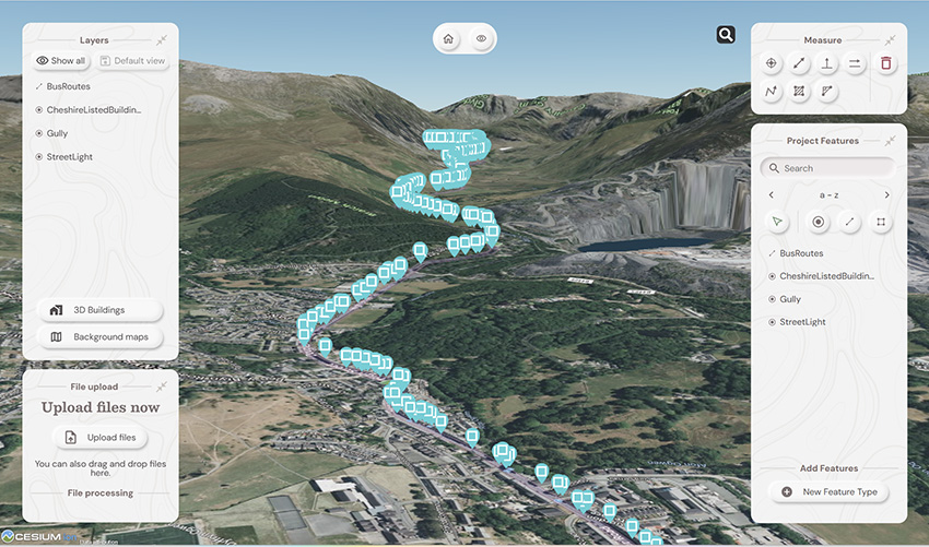
Soarvo is a new cloud-based geospatial data platform for surveyors, drone operators, and mapping specialists. It is designed for seamless data visualisation and sharing, supporting a wide variety of sources and file formats, all hosted in one place.
This strategic move enables KOREC to bring Soarvo to the geospatial professionals who need it most—those seeking a platform capable of handling and sharing the high-quality, dense datasets captured by industry-leading sensors such as drones, mobile mapping systems and 3D laser scanners.
Eliminating the need for expensive, complex hardware and software, Soarvo presents this data in a rich, multilayered 3D geographic environment.
Mark Poveda, Managing Director – UK & Ireland, KOREC Group said:
“Partnering with Soarvo is a strategic move that complements our mission to provide top-tier geospatial solutions. We are confident that this partnership will drive mutual growth and deliver exceptional results for our customers.”
Alan Browne, CEO and Co Founder – Soarvo said:
“This collaboration with KOREC will help Soarvo maximise its impact within the geospatial community. KOREC’s expertise and support will enhance the overall customer experience, ensuring that users receive the full benefits of Soarvo’s innovative 3D geospatial platform.”
About Soarvo
Founded by Alan Browne and Paul Brodin—an engineer and a software developer with decades of geospatial experience—Soarvo is all about making geospatial data management simple and accessible for professionals and their customers across various industries.
The Soarvo team has been built to deliver innovative geospatial data solutions that help users unlock the potential of their geospatial data and enhance collaboration for a more connected world. Soarvo is on a journey to turn geospatial data into actionable insights, optimising real-world outcomes for businesses and communities alike.
Request a demo at www.soarvo.com
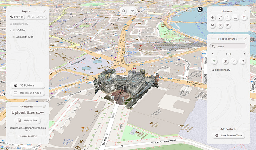
Soarvo provides context around your dataset and positions it in the real world on a choice of background map data
Download a PDF of the release here
The driving force behind Soarvo’s launch? Pure genius and a bit of fire and frustration too. Soarvo have come up with something designed to rescue a geospatial community drowning in much needed, excellent, high-quality data, but restricted in what they can do with it. Think of it as throwing a life belt… but make it a carefully developed revolutionary 3D geospatial platform instead!
Here at KOREC we have a long history in the development of geospatial data platforms. Go right back to the earliest days of GIS in the 90’s and we were there, developing, supporting and working with the very best. So trust us when we say we know a good thing when we see it – and that good thing is Soarvo.
Why’s it different?
The obvious question is what is Soarvo, and the easy answer is of course found in its official description as a “…..revolutionary 3D geospatial data platform, which enables users to Aggregate, Illustrate and Collaborate all in one place.”
That’s exactly what it ‘does’ but what makes it really different is why and how. Let’s go back a couple of years or so when the geospatial industry was spoilt for choice when it came to sensors for generating extremely large, accurate data sets whether that be from mobile mapping, drones or 3D Laser Scanners. The hardware was doing a great job! But what wasn’t so great was what was happening in many offices. Without the mother of all PC’s and a significant investment in multiple software packages, skills and office time, our fantastic, captured data was becoming either a bottle neck holding up projects or simply siloed.
Great data sets aren’t meant to be hidden away, they need to be shared, seen, and collaborated on, not just admired by a select few. That’s why geospatial professionals across all industries – from surveying to rail to mapping – were on the hunt for something that could handle it all and turn those data sets into useful info, fast. But could they find anything? Nope, there wasn’t a single package that could do the job… until now.
Soarvo is born!
The Soarvo aim was to create something with exceptional functionality and security but with a user-friendly interface as inviting as the hugely popular design software, Canva. So, we created Soarvo from the ground up, taking end-user feedback on board at every step of the development process.
And now it’s ready.
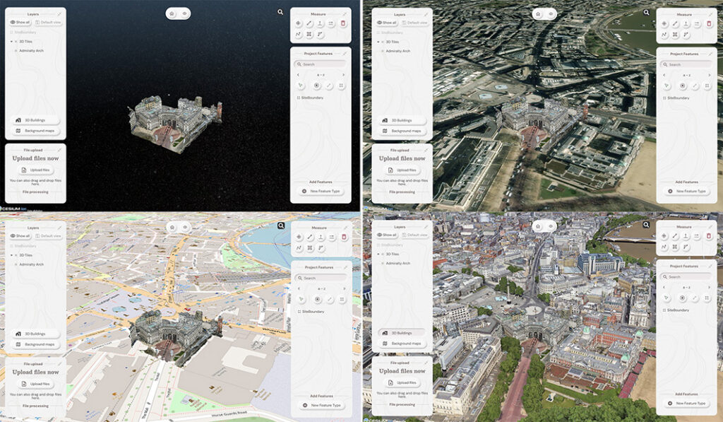
Top left: What you had. Remaining three pictures, adding context with SOARVO
Why it’s exciting? Our top five reasons
It’s extremely easy to use: The development’s been all about the user experience, with an interface built for ease of use. That’s why it looks and feels so different (in the best possible way) compared to other data sharing software out there.
Favourite feature of Paul Brodin, Technical Lead: “The visualisation functionality and the speed with which it loads. I know because I timed it – 15 seconds for a mobile mapping data set that previously took hours!”
It provides a unique view of your data compared to other platforms: Well, how does it do that? The answer is it provides context around your dataset and positions it in the real world. For example, your laser scan point cloud doesn’t sit in a black space, it’s positioned on to the background map of your choice from OS to Google to Bing. This opens up new doors with your clients. It’s all about making your data set relevant for its end users by providing visualisation in a rich 3D environment with analysis and measurement tools thrown in.
Favourite feature of Alan Browne, CEO and Co-Founder of SOARVO: “It’s all about the effortless processing of drone data – everything included and definitely no fuss required.”
It truly delivers on collaboration: Once your datasets are uploaded, you simply share a secure link to your chosen users and they can log in securely, via the cloud, for viewing or editing depending on their pre-determined rights. We don’t mess about with login limits – invite the whole team if you fancy because the whole point is sharing this information whether it be for visualisation, site planning, measurement, whatever.
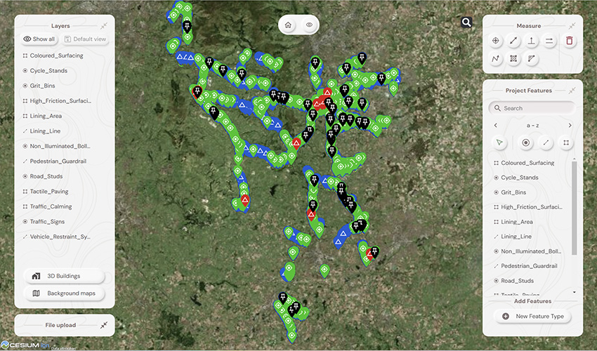
Everyone’s invited: As well as unlimited log ins, the software handles data from just about every sensor under the sun, seamlessly combining output from drones, laser scans, GNSS, total stations, mobile mapping, mixed reality, 3D models, CAD and GIS.
It’s a standalone tool for drone data: Capture your aerial data and drop it straight into SOARVO to create your deliverables whether that’s an ortho-mosaic, point cloud, or 3D model. No extra software, no faff—just process, share, and crack on!
Favourite feature of Richard Gauchwin, Senior Product Manager: “For me, it’s all about how it looks and also hearing the amazing reactions from our early access users. As someone who used to be in sales, being able to say ‘yes’ to so many questions just proves we’ve built something genuinely unique here.”
But don’t just take our word for it…
We love feedback and our early access users have provided exactly that:
Soarvo provides us with a platform to automatically process drone orthomosaics and view them within a web-based geospatial data solution. This capability is greatly beneficial to us—having a one-stop shop for all our drone and GIS needs in a single platform is both unique and highly valuable.
The ability to easily share project updates with clients, alongside geospatial and media data, has resolved a long-standing need for us. We now have greater flexibility to share data with contractors and provide updates online, without the need to email GIS files or rely on others to know how to use complex GIS software.
Having a central online location where our team can share data and collaborate easily on projects with online easy to use GIS tools makes workflows and data sharing much more efficient and accessible. Soarvo has provided us with an opportunity to streamline data management within the team.
Ease of navigation in 3D
Speed of rendering large point clouds and ability to move them
Simple clean interface and comprehensive basemap data
Favourite feature of Gabriel Hradilek, Chief Operating Officer: “A simple one from me, but absolutely massive for our customers: how easy and secure it is to share data. It’s a big deal, trust me!”
Need to know more, contact KOREC
Here at KOREC we’re delighted to be the UK & Irish distribution partner for SOARVO. That means when you get your hands on the new software, you’re also getting over 30 years of our know-how, support, and training – all backed up in our T.R.U.S.T. brand promise. Join the waitlist at https://soarvo.com/
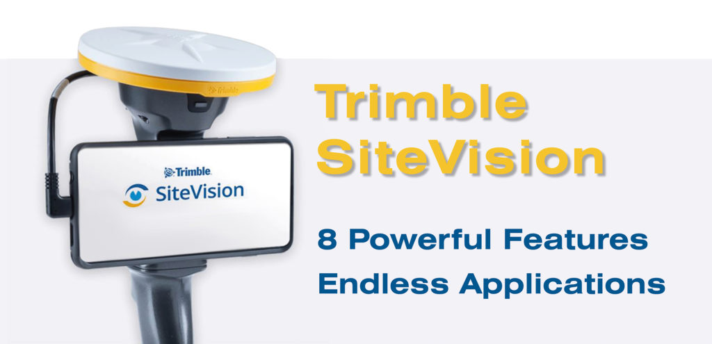
Trimble’s SiteVision is a geospatial tool created for today’s tech-savvy workforce.
Working in sync with your own mobile device, the unit utilises the very latest GNSS technology (including with the R12i – more on that to come) to pinpoint your design model down to cm accuracy.
This allows you to easily and accurately visualise your BIM design model in its true location, before a brick has been laid or concrete poured. What’s more, you can share that model, in real time, with your colleagues or with your client, wherever in the world they happen to be.
The solution is already in use across 1000’s of worksites globally, including here in both the UK & Ireland. Customers here include Gareth Price of O’Brien Contractors in the West Midlands, and the A14 Integrated Delivery Team (a JV of Costain, Skanska, Balfour Beatty & Atkins Jacobs) headed up by Mark Lawton – check out Mark’s thoughts on the device in the video below.
You can also read about the experience of O’Brien’s as they utilised the kit on a new stretch of light railway in our customer story.
The versatile and multi-featured tool lends itself to many industries including, to name a few; civil construction & inspection, building construction, utilities, urban transportation & planning, architecture & residential development, and more.
We’ve picked our Top 8 features of this extraordinary device, to show just how powerful and useful it is;
- Simple, intuitive operation with your smartphone
- Built-in data visualisation & modelling
- Clear & Simple Communication with Trimble Connect
- cm-accuracy thanks to GNSS integration – including the new R12i
- Safely measure distances in hazardous spots with EDM
- Easy & fast data reporting – notes, photos & assign tasks
- Always On – load your model even in internet blackspots
- Compatible with huge range of platforms & data formats
To see SiteVision for yourself, why not get in touch and arrange a demo with our friendly team? Contact Us

KOREC are delighted to today (11th August 2020) be announcing their new initiative, Meet the Experts, to further help and support their growing customer base.
The concept is to increase awareness and understanding of eight key business areas and solutions, which are;
- Laser scanning and Trimble RealWorks
- Mobile Mapping
- Trimble Business Center software
- Rail
- GIS & UAV Solutions
- Integrated Layout & Mixed Reality solutions
- Integrated Survey
- Monitoring
Each KOREC Expert has been selected for their specific experience, product knowledge, industry connections, and ability to share that knowledge with our customer base.
The initiative was launched with a introductory video interview with laser scanning expert, Melvin Penwill – watch the video here.
TBC 5.1 and Access 2019.00 have just come out.
Trimble Access version 2019.00 includes a new CAD toolbar to simplify linework creation and support for web map services for map background data. It also provides improvements to scan data display, and Favourites and Functions. IFC enhancements include improved display and layer control, faster model loading, support for large coordinate system translations, and the ability to create the center point on a surface for staking and measure to IFC surfaces.
Trimble Access version 2019.00 is now a 64-bit application and the following apps are available now: General Survey, Roads, Tunnels, Mines, Pipelines and Monitoring.
View the release notes here:
Improvements include:
Trimble Access 2019.00
- WMS map service
- IFC enhancements
- SX10 Point cloud viewing enhancements
- New CAD Toolbar
- Group favourites
- SX10 zoom function keys
- DXF and LandXML enhancements
TBCv 5.10
- Feature Code Library creation from within TBC
- IFC enhancements to go with TA
- Labelling enhancements
- Corridor and mass haul enhancements
- Mobile Mapping Enhancements
- Scanning as canning work flow enactments
For all those who use Trimble office software to post-process GNSS survey data there is now a new configuration update file available dated 20th May 2010.
This file updates the antenna and receiver information used in GPS post processing to ensure that the best possible levels of accuracy are achieved from your data.
As the Ordnance Survey take advantage of the regular improvements in receiver and antenna technology it is important to keep up to date with the characteristics of any new hardware in order to calculate GPS positions accurately and correctly.
The latest Configuration update file can be found at https://www.korecgroup.com/resources.php?cat=software within the “Utilities” section in a folder named “GPS Antenna Files”.