Who would use centimetre accuracy on a smartphone and what would this innovation mean for the geospatial industry?
At the end of 2016 we found ourselves asking these questions following the announcement of the world’s first software GNSS receiver, Trimble Catalyst. These are also the questions that KOREC’s Business Area Manager for Mapping & GIS, Richard Gauchwin, sought to answer in his article in the January issue of CES. In this piece Richard identifies the five key user groups that we have seen emerge since the launch of Catalyst:-
Who will use cm accuracy on a smartphone and what does this innovation mean for the geospatial industry? At the end of 2016, we found ourselves asking these questions following the announcement of Trimble Catalyst, the world’s first software GNSS receiver. Catalyst has been designed to run on Android phones and tablets and when used in conjunction with a small ‘plug and play’ low cost digital antenna, it turns these devices into cm accurate data collection tools.
Trimble Catalyst represents a new era of GNSS technology and a new business model – software as a service (SaaS). It’s available as an on-demand subscription service and offers a range of accuracies from 1m to centimetre level, priced accordingly. In short, it puts affordable, cm accuracy into the hands of any industry in the world that uses smart phones which I believe is pretty well all of them!
The ethos behind Catalyst is threefold; to make GNSS more accessible by adding a whole new level of functionality to a tool almost all of us have in our pocket, the smartphone; to make GNSS more accessible by removing complicated set ups involving base stations; to make GNSS more accessible by simplifying the delivery of the service.
Of course, the ubiquity of the smartphone and its enhanced processing power has been key to the timing of Catalyst as has the on-demand economy that continues to shape customers’ expectations in many business areas including the geospatial industry.
In terms of development, key requirements for any technology aimed at a broad user group are likely to include ‘small’, ‘light’, ‘user-friendly’, ‘accessible’ and ‘affordable’. Combine these elements and we have a list of the drivers behind Trimble Catalyst.
The Catalyst business model
It’s important to understand that the Catalyst business model is not the solution for every application that requires cm accuracy. My advice would always be to start with the workflow. For example, if the requirement is for accurate positioning on a project basis, then Catalyst would be a good option for short term use as an operating expense. It’s also ideal for a larger and broader user base where workflows could benefit from high-accuracy positions but the data collection is not the primary function of the workforce.
For large roll outs on contracts, the advantages of a software GNSS receiver can be immediate. Most people already have an android smartphone so the only required accessory is the lightweight, low priced digital antenna. No GNSS hardware is required because Catalyst is a software-defined GNSS receiver and users subscribe to the level of accuracy needed, centimetre, decimetre, sub-metre or metre, from a range of options priced from £35 per month.
As I mentioned earlier, simplicity was one of the driving factors in the development of Catalyst. On startup you just plug in the Catalyst antenna, select the best available correction service based on location and subscription level and off you go. But ease of use will also depend upon the choice of data capture software. We predict that the developers of this type of software will continue to work on making their solutions even more intuitive to the non-expert, to the extent where training can be cut to just an initial short phone call, again reducing project costs.
The expectation is that this type of technology and business model will extend the accessibility of high accuracy positioning way beyond the ‘core’ of geospatial users already familiar with it and into the hands of anyone who wants to collect accurate special intelligence. However, Trimble Catalyst has only been available in the UK since July 2017 and as yet, the data collection apps it is compatible with are recognisable names from the industry, Trimble’s Terraflex, KOREC’s K-Mobile and Esri’s Collector App, all developed for general field data collection. However, Trimble’s downloadable software development kit (SDK), means that we are already starting to see companies with existing apps looking to integrate them with Catalyst. This will provide an interesting indicator as to who is really making this technology work for them. Early developers include a company specialising in the precise positioning of trip hazards on pavements and a construction company with an augmented reality solution that places digital objects into the view of the physical world.
Early adoption and the emergence of key users
Based on the last 5 months we are seeing clear indicators as to where the interest in this type of SaaS lies. Although it’s early days, we can broadly group those taking up the technology into five different types of user.
Users for whom affordable cm accuracy can greatly enhance their day to day business but cannot justify the expense of a dedicated high accuracy GNSS receiver or the cost of sporadically having a surveyor or second team on site. Top of this list has to be the drone operators we work with who wish to establish ground control for their aerial mapping projects. Ground control increases x,y,z accuracy which enables a project to be scaled in all three axes and allows users to add value to their offering through accurate 3D measurements. Ground control also ensures correct geo location of the surveyed site by tying into the OS Grid. Previously the expense of buying a GNSS to deliver the cm accuracy required for establishing ground control would have cost more than the drone itself. This simply would not be viable for a ‘value add’ to an existing service.
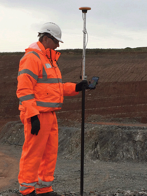
Using Trimble Catalyst for UAV ground control points at a UK quarry site
Also falling into this group is a customer that specialises in pipelines and wished to close the gap between expected compliance and what really happens on site. Previously this customer was taking georeferenced photos and recording relevant positions, such as pipe valves, for QA purposes just using a standard mobile phone. However, the lack of accuracy with this system meant that pipes could be located on the wrong side of the road or even in people’s gardens. Catalyst has provided a low-cost solution that has elevated their QA reporting to a new level allowing them to provide accurate digital plans of their work.
Users who already understand and use high accuracy GNSS but require additional systems for carrying out ‘irregular’ surveys. Typically, any large civil engineering project in the UK, whether it be roads, rail or building construction will see an onsite team of busy survey professionals undertaking a range of surveying tasks from setting out to as-builts, all on a daily basis. Supporting the main task will be other smaller teams, vital to the smooth running of the project, but with little or no survey experience, for example, those carrying out soil analysis or borehole sampling. Whilst it’s vital to have an accurate location for a test area or borehole if you are to navigate back to them, especially in overgrown areas, it’s not something that a major contractor would want to commit survey resources to.
Additionally, much of our new SaaS business is with utility companies including one responsible for creating manhole cards. This company’s field workers are recording lots of attribute information including manhole location, cover shape, chamber size, ladder position and pipe direction and diameters all backed up by photographic evidence. However, all this attribute information needs to be attached to an accurate position for the presentation of a complete condition report.
Users who have never used cm accuracy before and have no survey experience. A great example in this area is a company we’ve been working with that specialises in designing and installing agricultural irrigation systems. Previously, they would install a system and simply record all the information relevant to the installation using pen and paper. Now, for the first time, they can access cm accuracy on their mobiles and position all the information they need to create an accurate plan of what’s been installed, the pipe levels, direction of flow etc – vital information for the maintenance and development of each customer’s system whilst adding value to their own proposition.
Users who require on-demand cm accuracy as part of a fully customised solution where position is just one piece of the puzzle. Our KOREC software development team works in partnership with many companies advancing and tweaking their data capture systems to fit a specific workflow. Already we have customers coming to us for whom Catalyst is the starting point for a fully customised system. A useful example here is the testing companies that we’ve been dealing with. Responsible for testing things such as lighting columns, masts or signalling equipment, it’s their job to ensure a column’s safety and to establish when it may need replacing. Previously the test results, documentation and evaluation for this process were all recorded on paper. Testing companies have come to us with a view to digitising the process and are now using Catalyst to provide the cm accuracy of the column positions in conjunction with customised KOREC K-Mobile software for the collection of the required attribute information. The KOREC system also automatically bundles this information into a pdf report for immediate transfer to the office. This means that those responsible for the safety of the assessed columns can react to failed tests immediately and located the correct column without delay.
Users we could never have predicted! I mentioned at the beginning of this piece that the Trimble Catalyst business model puts affordable cm accuracy into the hands of any industry in the world that uses smart phones and believe me, that really could mean any industry at all! We can’t wait to see how people take up this technology and we are already receiving some interesting feedback courtesy of the Ordnance Survey’s GeoVation Hub which was the recipient of a Trimble gift of Catalyst licenses. The Hub is home to a group of innovators ranging from Big Data users providing insurance risk analysis for drone flights to the makers of collaborative real-time infrastructure planning tools. We’re already hearing reports of Catalyst being used with ground based drones. Watch this space!

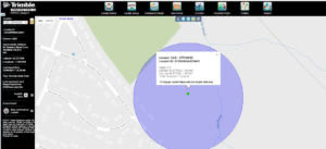
Kerb line surveyed to 1cm accuracy using Trimble Catalyst shown on Ordnance Survey Mastermap
An evolving technology
Catalyst will continue to develop and this evolution will be led by customer demand. Indeed, we are already seeing this with the arrival of GLONASS signals for even better coverage in challenging areas such as city centres.
Trimble is aware that services such as ‘pay per view’ shape customers’ expectations in our markets which may make other subscription options a possibility. Catalyst for iOS is another development which would fit into the Trimble customer business process. Finally, Trimble is also actively seeking third party developers wishing to integrate their applications with Catalyst, something underlined by its gift of licenses to the Ordnance Survey’s Geovation Hub. This new generation of users is also likely to shape the future of Catalyst.
In conclusion, by putting cm accuracy into the hands of those outside traditional geospatial business areas we can expect further progress in the democratisation of data as it becomes more usable and more understandable by more people. This will allow many businesses to expand away from being just data providers to service providers adding a whole new level of value to what they do and what we as an industry can offer. Who knows where the combination of low cost cm accuracy and open access will lead us and I for one can’t wait to find out!
It’s always good to hear about technology that works exactly as intended which is why we are delighted to report that Trimble’s L2P (Locate2Protect) real-time equipment monitoring has saved KOREC customer Central Alliance from the inconvenience and expense that follows the theft of an instrument.
All new Trimble S-Series Total Stations come with L2P built-in so when an opportunistic theft by moped resulted in Central Alliance losing a Trimble S9, Principal Land Surveyor Milen Charov immediately informed the police and called KOREC. Via the L2P portal, KOREC’s Technical Support was able to locate the instrument and track it live as it moved away from the site. When the instrument position remained static, KOREC sent Milen the latitude and longitude of the missing instrument and he was able to retrieve it from the bush where it had been discarded, unharmed and needing nothing more than a check.
Milen told us, “KOREC’s response couldn’t have been faster. The down-time caused by the loss of an instrument along with the hassle of dealing with insurance claims is extremely inconvenient. L2P is a great service and it’s saved us trouble, time and money. After an incident like this we have realised how important the locator functionality is. It’s absolutely worth it and I strongly recommend it.”
What can the industry do to help combat industry theft? Read our TSA report here.
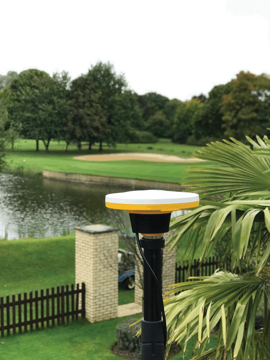
 Those mapping golf courses, especially for TV coverage of events, choose to use a Trimble Geo7x with CenterPoint RTX for mapping the outlines of greens and bunkers. This 4cm positioning service eliminates a ‘hexagonal’ effect when mapping these areas instead producing a smooth outline.
For Mark Humphrey, Director of L&SS and the first KOREC customer to invest in Trimble’s R10 GNSS, xFill has proved particularly useful. At the time of purchase Mark was working as an ‘on call’ surveyor on the £1.5bn DP world owned London Gateway project. He couldn’t afford to have down time and cited one of the most productive benefits of the R10 as being its high accuracy (used in conjunction with Trimble VRS Now) and its xFill technology which allowed him to survey continuously, even when the size of stockpiles interfered with the radio link to the base station. A fully case study can be read here.
Oxford University has been working in Greece using a Trimble R10 GNSS in conjunction with CenterPoint RTX for archaeology surveys. It’s proved a great back up when they are out of their base’s range.
The RSPB favours a Trimble R1 with ViewPoint RTK for affordable 1 metre accuracy on a project in the South Atlantic.
The Highways Agency has 100+ Trimble VRS Now licenses delivering centimetre accuracy on demand for the Police to use their GNSS receivers easily and accurately to survey road incidents as quickly as possible to reduce congestion.
Selecting the best positioning option for your site.
Our quick guide to the ins and outs of KOREC’s positioning services including Trimble VRS Now, Trimble RTX and Trimble xFill
Trimble VRS Now
 In short: Trimble VRS Now is a network RTK service that provides users with instant access to RTK corrections. Using precise data supplied by a dense network of reference stations, VRS Now can deliver centimetre level RTK anywhere in the network, customised for each rover’s exact location. It’s widely used by KOREC customers and much praised for its reliability.
Suitable for: Any site engineer who requires a super reliable positioning service with fast initialisation times and accuracies of 25mm. Especially useful for engineers who have to visit several different sites during a day or those who work on long linear sites.
Trimble VRS Now is suitable for use with Trimble GNSS rovers and also offers clear benefits over other area network solutions, even when used with 3rd party receivers.
Cost: Subscription based service
Further information: A handy run down on VRS Now FAQs can be read here.
Trimble RTX
 In short: RTX is a new positioning technology that brings together the advantages of new techniques that do not require a local reference station network or a mobile phone connection, whilst providing the productivity of RTK positioning. Four options are available with signals received either via satellite or via IP/cellular.
Suitable for: Any site where mobile phone coverage is non-existent or compromised and applications where high accuracy and fast initialisation aren’t priorities.
- CenterPoint RTX – 4 cm accuracy. CenterPoint RTXisTrimble RTX’s premier correction service converging to full accuracy in 1-5 minutes in select regions (including the UK and Ireland), and less than 30 minutes worldwide. Compatible with the Trimble NetR9 Geospatial, Trimble R10, Trimble R2, Trimble R9s GNSS Receiver and Trimble Geo7X handheld. Subscription service
- FieldPoint RTX – decimetre accuracy. A mid-level option compatible with the Trimble R2 GNSS receiver and Trimble Geo 7X. Subscription service
- RangePoint RTX – sub 50 cm accuracy. An affordable correction service compatible with the Trimble Geo7X handheld and Trimble R2. Subscription service
- ViewPoint RTX – 1 metre accuracy. Affordable entry level accuracy compatible with the Trimble Geo7X handheld, Trimble R1 and Trimble R2. Subscription service
Cost: CenterPoint, FieldPoint, RangePoint and ViewPoint are subscription based services.
Further information: Full information on Trimble’s RTX Positioning Services can be found here.
Trimble xFill

In short: The jewel in the RTX portfolio is Trimble xFill! A technology that’s always there when you need it. Trimble xFill, powered by Trimble RTX, technology, runs seamlessly in the background, automatically bridging the gap if an RTK or VRS correction source is interrupted due to cellular signal disruption or loss of radio line of sight, allowing you to maintain centimetre-level corrections.
Suitable for: All surveyors who wish to remain productive on sites where their signal might be compromised by tree canopy, stockpiles etc
Cost: Trimble xFill continues to be free for the first 5 minutes of use on all compatible receivers with no degradation of accuracy. Additionally it can also now be used indefinitely beyond 5 minutes on the Trimble R10 and NetR9 Geospatial receivers with a valid CenterPoint RTX subscription.
Further information: Full information on Trimble xFill can be found here.
Why Greenhatch Group switched to Trimble VRS Now

Greenhatch surveyor Scott Smith with Trimble R10
Surveyors want reliable data. They also want to maximise their time on site. When these basic requirements are compromised, businesses will take fast and efficient measures to rectify any issues that could affect hard won and carefully nurtured customer relationships.
For Greenhatch Group Ltd, this entailed the introduction of a completely new positioning correction service for use with their 14 GNSS/GPS systems when their old set up failed to deliver the quality of data, reliability and peace of mind that they required.
Greenhatch Group can trace its origins back to an early offering of surveying services over 35 years ago and today operates through a national network of three regional offices. Employing over 70 staff, the company has expanded in the last few years to offer a wide range of surveying services from topo and measured building surveys to specialist undertakings such as 3D laser scanning, BIM/REVIT Models, bathymetric surveys and aerial drone surveys.
With the core of its business being topographical and measured building surveys, the company depends upon the reliable performance of its optical and GPS/GNSS instrumentation and was therefore quick to react when the performance of its existing RTK broadcast correction service aroused concerns.
Analysing the problem
In 2015 Greenhatch Group’s 14 GNSS/GPS systems were linked to the Leica Geosystems SmartNet RTK Network via supplier approved ‘roaming’ SIMs cards licensed under a 3 year subscription deal. Whilst Greenhatch Group Director Neil Jefferies felt that this solution delivered on many of the sites his surveyors visited, he was concerned that, overall, the combination of the service provided, equipment and SI card was unreliable. Coordinate quality wasn’t sufficiently achieved on a number of sites up and down the country and the amount of lost time due to broken connections was immeasurable. In short, Neil felt that there was considerable room for improvement and that the Group’s correction service should be providing them with more reliable returns.
Trialling solutions…
Greenhatch Group tried various solutions to improve its operational times with the RTK Network. These included upgrading to private APN (Access Point Name) SIM cards and trying SIM cards from different service providers, even to the extent of having a wallet containing separate O2, Vodafone, EE and 3 pay as you go SIM cards for each GPS system. Different combinations of GNSS models and receivers were also tried to see if the loss of connection was a hardware problem and this was supplemented by Greenhatch surveyors keeping a log of each lost/broken connection, recording both time and location.
Only the multi SIM card approach brought any improvement but with that improvement came a set of new problems. Constantly switching SIM cards and settings became tiresome with less experienced users becoming mired in a world of menus and settings and the GNSS rovers were suffering from repeated openings and closings to insert the cards.
…and finding the answer
Greenhatch came upon its solution by chance when a KOREC sales consultant was visiting during one of the surveyor’s – by now daily – reports of a failed RTK connection. The KOREC consultant was able to talk Neil through the benefits of VRS Now, Trimble’s RTK subscription service, and within 48 hours had arranged the loan of a SIM card providing Greenhatch with immediate access.
A GNSS rover was selected and a Greenhatch surveyor sent out as a ‘guinea pig’ to trial VRS Now whilst Greenhatch’s management prepared to field his calls and relay any problems back to KOREC.
“We didn’t receive a single call,” reports Greenhatch director Neil Jefferies. “We later saw our test surveyor in the office and he said that he’d had no issues at all and connection had been good throughout the trial. In fact, his only complaint was that his legs hurt from walking all day!”
To further assess the situation, KOREC additionally loaned Greenhatch a Trimble R10 rover with VRS Now to compare with their existing Leica GNSS also with VRS Now. Following this trial two R10s were purchased along with 15 VRS Now licenses to cover the company’s entire GPS/GNSS fleet.
Neil concludes, “Previously our surveyors were getting frustrated on site. They simply wanted to complete jobs and get home but with the old system they were never sure whether it was going to be a good day or a bad one. Since switching to VRS Now, the number of calls from site surveyors saying they are not going to finish projects, or that they need to return due to GPS issues, has reduced to a level where it is very rare to get one at all. This has also minimised the time technical staff and management have to spend responding to their calls allowing them to concentrate on other parts of the business instead. There is no doubt that for Greenhatch, the benefits of Trimble VRS now can be summed up in a single word – reliability.”
Case study
Greenhatch Group director, Neil Jeffries, reports that a multi-acre greenfield site was recently surveyed by Greenhatch. Traditionally the survey team would use a total station to survey hard detail and boundaries and use GNSS units to infill levels within the fields.
Neil has a general idea of how many acres per day are achievable by a surveyor using a GNSS unit and this includes some down time to cover connection issues. Upon surveying the site with units connected to VRS Now, the systems completed the work 10-20% faster than anticipated compared to similar sites undertaken in the past with the original equipment set up. This project was valued at around £15,000 and Neil affirms that thanks to the reliability and efficiency of the Trimble VRS Now service, cost savings can be calculated at £2,500.
Andrew Beckerson, KOREC’s Director of Business Development comments “Greenhatch’s experience with Trimble VRS Now echoes what many users have found, reliable real-time GNSS correction data will increase your profitability, proving once again that ‘not all correction services are the same.’

VRS Now fact box:
- Availability: Unites States, Europe and Australia
- High Accuracy: Provides < 2 cm (1″) accuracy*
- Ideal for a variety of industries needing high precision including survey and construction, mapping and GIS, cadastral, utilities, transportation and areas having good cellular coverage
- Instant Initialization: Start working immediately under optimal conditions**
- Multi-constellation support: GPS and GLONASS enabled
- More uptime: Built-in redundancy to ensure connectivity, consistency and quality
- No base station required: No need to worry about losing radio signal reception since a base station is not needed for Trimble VRS Now based correction services
- Ease of Use: Online self-service portal to activate subscriptions.
* All horizontal accuracy specifications are based on in-field performance 95% of the time.
** Receiver initialization time varies based on GNSS constellation health, level of multipath, and proximity to obstructions such as large trees and buildings.

Great Scott!
KOREC Mapping Consultants Brock Ryder and Andrew Blogg have definitely launched something into the sky – but what is it?!
Keep watching our front page news section for an exciting announcement on the latest addition to the KOREC mapping portfolio.

CAT D7E & Trimble on the KOREC stand
Hillhead 2010 has just finished and this years glorious weather was appreciated by visitors and exhibitors alike.
Aided by Trimble and Finning, the KOREC stand was busy for the duration with the full Trimble range of Machine Control and Site Positioning Systems on show, all backed up by KOREC’s expertise.
As predicted, the Finning supplied Caterpillar D7E with Trimble’s GCS900 system, attracted lots of attention. KOREC’s Peter Brooks explains, “We asked Finning if they could help us out at this years show by providing a Caterpillar D7E for our stand. This machine – the first-ever electric drive track-type tractor D7E consuming up to 20 percent less fuel while increasing the productivity by 10 percent – reflects just what the business is all about, innovation and technology and ultimately sustainability.”
There was also a huge amount of interest in the Trimble Site Positioning Systems demonstrated the stand. Contractors were keen to learn how the SPS products can utilise GPS or Robotic Total Stations to help them improve their efficiency on site with the use of the Trimble SCS900 Site Controller Software.
To find out more about the CAT D7E and ‘Lastability’ please visit the Finning site

Perfectly level surface – Nadal has no problem showing his first round opponent the door at this years Wimbledon
Wimbledon fortnight is upon us and Centre Court is looking better than ever!
Could this be down to the trimming up of the base materials with a Blec dragbox and a Spectra laser grading system supplied by KOREC’s own Peter Brooks?

Using Trimble GPS to map Japanese Knotweed in Cornwall
Register now to join KOREC and Trimble® at Europe’s largest sustainability event which takes place next week at London’s ExCel. Futuresource is a joint event from the Chartered Institution of Wastes Management (CIWM) and the Environmental Services Association (ESA) and provides a forum for debating key issues, discussing best practice and sharing expertise and solutions.
KOREC will be joining Trimble’s Environmental solutions team on stand number B24, showcasing Trimble’s environmental solutions which cover all aspects and every step of the waste management process. The portfolio provides complete positioning solutions and services, starting at the waste collection, transportation through to its recycling and disposal at modern sanitary landfills or waste-to-energy facilities.
KOREC’s Machine Control Manager Pete Brooks will be on the stand to discuss ways that Trimble’s Machine

Trimble compaction systems at work on landfill
Control and Site Positioning Systems can be used to improve the construction, management and maintenance of landfill sites. In properly managing this issue, having the latest equipment and technology ensures that projects are planned and tasks are executed efficiently.
Trimble’s Eurpopean Sales Manager for Environmental Solutions Goran Jedrejčić will be available to discuss how Trimble’s range of solutions can be used in the Environmental services industry, supporting those who provide land and water management services that help preserve natural resources or ecosystems. Whether your environmental services include site assessment, remediation, survey, mapping, land or marine, Trimble solutions can help get the job done faster, with more accuracy and with improved efficiency.
To register to attend, please visit the Futuresource website.