Fairyhouse Racecourse leads the way in consistent, centimetre accurate, sectional timing data with IHRB approved low-cost, ground-breaking Trimble GPS system.
Download a PDF of the story here
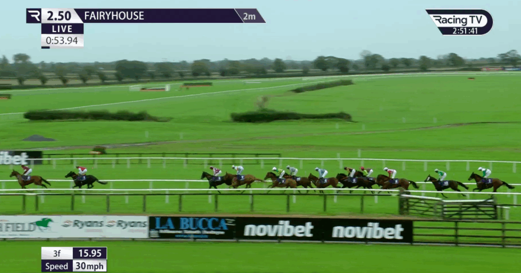
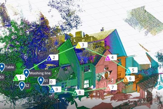
Typical on-screen information generated by Course Track from data captured by the Trimble Catalyst system
There have been longstanding concerns about the accuracy of sectional times in Irish race meetings particularly following some high-profile queries on race distances. However, Irish racing is addressing the problem and leading the way is Fairyhouse Racecourse, one of the country’s premier horse racing venues and home of the Irish Grand National.
In the world of horse racing, where comparisons related to pace, ground conditions and distance are paramount for form-study, the accuracy of furlong distance measurement is of utmost importance. Equally crucial is ensuring that the furlong measurements align with the timings displayed on television broadcasts.
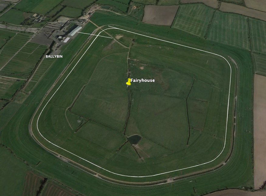
Fairyhouse has proactively addressed this issue with the adoption of a centimetre accurate GPS solution that they have customised for the production of highly accurate maps of every course circuit for each of its twenty-one annual meetings. Under the guidance of Fairyhouse General Manager, Peter Roe and Track Foreman, Richard Stapleton, the course has rigorously tested, implemented, and secured approval from both the IHRB and CourseTrack (tasked with introducing sectional timing by 01/24) for its new Trimble Catalyst GPS system. The system was purchased from Trimble distributor and geospatial specialists, KOREC.
Peter Roe is especially aware of the racing industry’s increasing demand for precise data, numbers, and information for assessing a horse’s form correctly. “Unfortunately, traditional survey methods that rely on measuring wheels have proved inadequate in delivering accurate furlong measurements to the extent that we’ve had races where all seven runners appeared to break the track record. Subsequent checks revealed that the race was run over a shorter distance than initially advertised. Extensive testing by Fairyhouse of wheel measurements compared to our new survey level Trimble GPS have revealed discrepancies as high as 32m over an 8-furlong race.”
Easy to use, low cost and consistent centimetre accuracy
As the first racecourse to independently look at the technology that could assist with accurate furlong measurement for sectional timing data, both Peter and Richard were keen to implement a system that not only worked for them, but would be easily usable by other interested racecourses. Their three demands of any new system were that it was easy to use, especially for courses where staff were less technical; it had to produce reliable centimetre positions and it had to be affordable:
Achieving cm accuracy: Whilst the survey industry offers many centimetre accurate GPS systems, these tend to be designed for professional surveyors and therefore come with an extensive range of features designed for survey workflows and can cost in excess of €30,000. However, through farming contacts, Peter was aware of an alternative system, called Trimble Catalyst, that worked on an entirely different subscription-based model.
The Trimble Catalyst business model has been developed for people exactly like Peter and Richard who wish to pay only when they use the system because they require centimetre positions to supplement their primary area of work rather than all day, everyday.
The Trimble Catalyst hardware comprises a simple, low cost, lightweight Trimble DA2 GNSS receiver which offers survey-quality (cm) positioning, even in challenging GPS environments including near and among trees and buildings. The receiver is easily connected to an Android or iOS device. Fairyhouse selected a handheld Nautiz X6 ultra rugged Android phablet as being the most suitable handheld to work with their Catalyst system. The field software running on board the Nautiz X6 was KOREC’s in-house suite of customisable software, K-MATIC, including K-CAPTURE field software. The K-MATIC suite also includes the highly secure, KLEARVIEW360 cloud-based Portal for analysing, viewing and sharing the collected information.
Low cost: The cost of the Trimble Catalyst DA2 receiver part of the system has been kept at less than €500 per unit and comes with an ‘on demand’ subscription pricing model so users can select the accuracy they need, 1cm, 10cm, 30cm or 60cm. Richard opted for a 1cm accuracy subscription optioned in hourly bundles which he knew from testing, would give him sufficient time to measure the course circuit at a brisk pace to keep it within the hour.
“Ease of use has been a key concern for us in working with KOREC to create a system that’s going to be useful for other courses, some of whom would only be using it four times a year. KOREC’s customer service and technical support have been brilliant – we didn’t just buy a tool but also a team!”
Richard Stapleton, Track Foreman, Fairyhouse
Ease of use: Whilst Richard acknowledges that he is obsessed with accuracy and good with numbers he is also aware that for any system to be widely taken up it has to be easy to use and understandable with a single days training. He therefore worked closely with the KOREC development team to develop a stripped back data entry form that was based exactly on the information that the UK media company required. This included the auto recording of the race line as it was walked by Richard and the ability to stop and mark each furlong and then continue the measurement of the race line. “Ease of use has been a key concern for us in working with KOREC to create a system that’s going to be useful for other courses, some of whom would only be using it four times a year. Whilst we have customised the software, I think it can still be simplified further. The attraction of a wheel is that it requires no training whatsoever and whilst we’re never going to achieve that, our Catalyst system has been simplified with customised features specifically for furlong measurement.”
“The aim was always for Fairyhouse to be 100% accurate. Our extensive testing of wheel measurements compared to our new survey level Trimble GPS have revealed discrepancies as high as 32m over an 8-furlong race.”
Peter Roe, General Manager, Fairyhouse
Using the system
Although the Trimble Catalyst system is very light and highly portable over long distances, Richard has opted to use it in a backpack to keep his hands free for positioning furlong markers etc. In preparation for races, the rail has to be positioned as early as possible and then Richard will walk the track, measuring one metre out from the rail. The reliability of the system is key to its success particularly when races are run over three days, such as the Easter Festival, which can see him marking out six race lines. This has to be completed in plenty of time to supply the information to CourseTrack in England.
Accurate timing data is now being generated
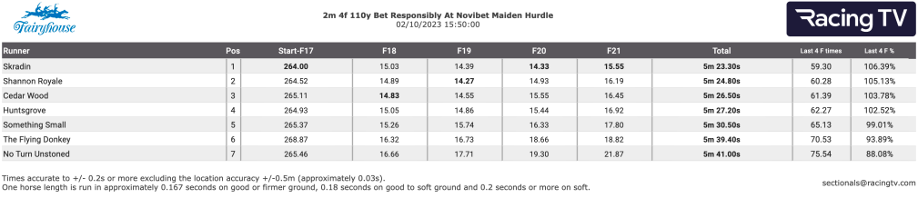
For each circuit, Richard establishes vital reference points on the track which allow him to accurately position the start and the finish lines. Once the data is collected, it is downloaded onto the Portal for a visual check of the map and to ensure that all furlong markers and bends are correct. It is then emailed to all those who require the course information. On race days the information is used by CourseTrack to link up with trackers that each horse carried in its saddle cloth to provide accurate timing data.
“The CourseTrack system relies on accurate measurement of race distances and track layout in order to deliver sectional timing for each individual race. The team at KOREC has worked closely with Fairyhouse and other tracks in Ireland to create a bespoke product for those racecourses which the system suits, and we have high levels of confidence that the KOREC data can support accurate live and post-race data.”
Chris Murtagh, Director of Operations, CourseTrack
A visual check is always made of captured information
Future plans
While Peter emphasises the solution’s standout benefit of delivering reliable centimetre positions, he also acknowledges the vital role of KOREC’s support in the system’s successful adoption.
“Our aim was always for Fairyhouse to be 100% accurate and I think that we’ve achieved that. KOREC has been extremely loyal to Fairyhouse on this project. We invited them to come on a journey with us that may or may not work out and they’ve supported us throughout and now we’re both being rewarded. The Catalyst system is a game changer and we’ve got plans to customise it further by adding in fences and distances to create some really nice visuals for social media. It could be an amazing tool for the industry.”
Richard concludes, “KOREC’s customer service and technical support have been brilliant and I feel that we didn’t just buy a tool but also a team!”
Several other tracks have recognised the system’s value and the dedicated efforts of Peter and Richard in securing its approval, leading to further adoption across Irish courses.
KOREC Group recruits software industry expert to lead large-scale expansion of its K-MATIC operations
The full release can be found here
We are delighted to announce the appointment of Gabriel Hradilek in the new position of Chief Operating Office of K-MATIC, our in-house software development division.
K-MATIC provides customisable solutions for the collection, analysis and processing of geospatial data through a combination of its K-CAPTURE field data capture software, its K-PORTAL and Trimble hardware solutions. Gabriel will manage the next stage in the expansion of these areas.
In this new role, Gabriel will be working alongside KOREC Group CEO Alan Browne, and K-MATIC Software Lead Paul Brodin, to manage an ambitious investment program that will see K-MATIC triple in size by the end of 2022. Specialising in deep industry-focused product and services software development, Gabriel brings experience from high profile previous roles working with global brands such as IBM.
KOREC Group CEO, Alan Browne said: “With a particular interest in helping companies absorb, apply and profit from disruptive digital technologies, Gabriel’s experience is a perfect fit for the ambitious plans we have for K-MATIC as we expand both the breadth and geographical potential of the software we develop.”
Gabriel Hradilek said: “I’m delighted to be taking up the role of Chief Operating Officer of K-MATIC. During my professional career I`ve worked with a number of deep industry-focused product and services software development organisations across the globe, big and small. However, very few of them were actually focused on creating their own market like K-MATIC does in the geospatial, engineering and construction sectors. Its innovative approach to solving the specific problems of a client or vertical market provide tremendous scope for a successful future.”
ENDS
Here’s a question. How do you continue to motivate, inspire, inform, or even just get your teams together during a national lockdown?
Whilst 2020 has been unusual (to say the least), for KOREC, we were already quite used to remote working & collaboration. Serving two nations, and with staff the width and breadth of the country, regular communication via phone, email, virtual chat or even Whatsapp was already the norm for many.
But for those used to office working or field working, now confined to the kitchen table at home, we realised that it was more important than ever to ensure everyone felt connected & informed.
That’s why we launched our virtual lunch ‘n’ learn series in October. The objective was simple – every 2 weeks, we invite everyone in the organisation to a brief overview of a product, solution or application. The vibe is informal – questions and interruptions are very much welcomed, prizes are awarded, and of course, lunch is munched.
It’s the perfect opportunity for a refresher on a particular product, an introduction to the latest piece of kit on the market, all presented by one of our in-house experts. For our people, it’s a reminder of the sheer variety & versatility of the solutions that KOREC offers, be it land survey, drone, rail, highways, mobile mapping…the list goes on.
It’s an excellent way for many of us to take 30 minutes out of our day, to get together, have a chat, and even learn something new.
So far, we’ve held 3 sessions;
An overview of our in-house, K-Matic software suite, presented by Darrell Theobalds
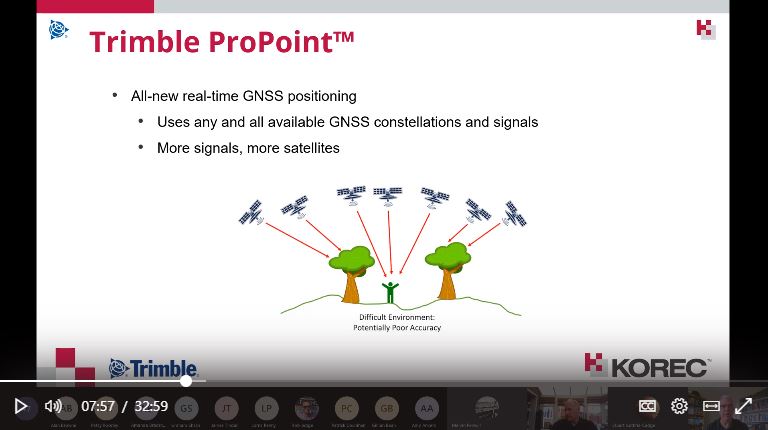
Introduction to the R12 & R12i GNSS systems & ProPoint, hosted by Leigh Rowell
Laser scanning made simple, with the X7, presented by Melvin Penwill
And we have many more up our sleeves going into 2021.
How examining your database can shape your company’s future. KOREC’s Business Area Manager – Mapping & GIS, Richard Gauchwin, shares some thoughts on how our GIS and mapping customer base has changed over the years and what this means for the future.
With GDPR well and truly upon us, here at KOREC we’ve be closely examining our customer database to ensure that only those of you who wish to hear from us do.
Taking the time to analyse our customer data has reminded us just how many industries we’ve been working with and how varied our customer applications are. But what can we learn from our changing database and how will it shape our future plans?
Emphasis on efficiency – more industries are going digital
A decade ago, KOREC’s strongest message for potential mapping customers was ‘…if you want to become more efficient in both the field and the office, ditch the pen and paper and go digital’. Our case studies focused on ‘core user’ examples involving street column surveys, cemetery mapping and street furniture inventories with the collected data usually managed on a corporate GIS. Today, our database shows that adoption of digital data capture, digital inspections and digital data verification is now widespread across a broad base of users, and it’s easy to understand why. Whilst the need for greater efficiency never diminishes, fortunately the cost of the relevant hardware and the length of the software learning curve has!
KOREC Opinion – With these barriers removed, going digital is a ‘no brainer’ – the benefits far outweigh the investment! We expect the market to grow and broaden.
Our customers seek solutions rather than products
There is no doubt that today’s KOREC/K-Mobile customer has a far more sophisticated approach to data capture than ever before. It goes way beyond the initial need for a product or system that simply enables the recording of just the positional and attribute information that we were still seeing even five years ago. KOREC customers now want this geospatial element to be part of an overall workflow where the end product is intelligent data that can be queried and used for proactive rather than reactive purposes. Our customers don’t want to just know where a certain gully is, they want to know when it was last cleaned? How often does it flood? Does its maintenance programme need changing from every six months to every two months. In short, can it be part of a proactive maintenance problem that will improve efficiency and cut costs?
KOREC Opinion – More and more of our customers want a fully integrated system that allows them to capture, update and query information in a seamless process. We’ll be continuing to develop K- Portal, our hosted, cloud based solution for the live monitoring of a project’s progress and the assignment of work orders based on intelligent information. In a recent industry survey*, 84% of respondees think users are now demanding complete workflow solutions rather than standalone products and we’re completely in agreement.
Customisation is king!
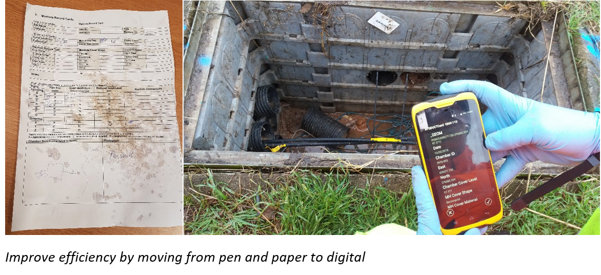
We’ve recently devoted a whole Let’s Be Specific article to this very subject and it’s just been published in Geomatics World. During the past twelve months, KOREC’s in-house software development team has been approached many times over by customers with very specific requests. For example, “We want to move from pen and paper to digital data collection and retain our existing workflow because it works well but off-the-peg data capture software won’t allow us to do this.” Or “We want software that automatically calculates a value we need out in the field for immediate decision making rather than our current system that requires us to process information back in the office.”
KOREC Opinion – Our in-house software development team has customised applications on behalf of many industries. But here’s another thought, if customisation is generally accepted as a crucial element in the successful take-up of a system, why not create data capture systems that are not just application/industry specific but customer specific?….and that’s exactly what we’re doing by handling requests from the smallest tweak to full systems. We expect widespread take-up of customer specific solutions.
Greater acceptance of cloud computing and its benefits
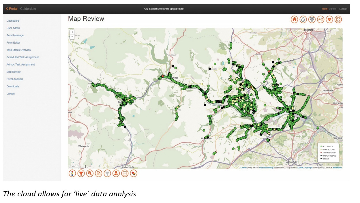
Not so long ago, ‘The Cloud’ was viewed as a slightly suspicious concept that may or may not be secure. Five years on and it’s been an industry game changer. Importantly, access to the cloud is through any web browser, minimising impact on IT infrastructure and resources. This easy access, combined with the increased bandwidth for storage, processing and sharing of data, has changed the way we present data, share it and act upon it.
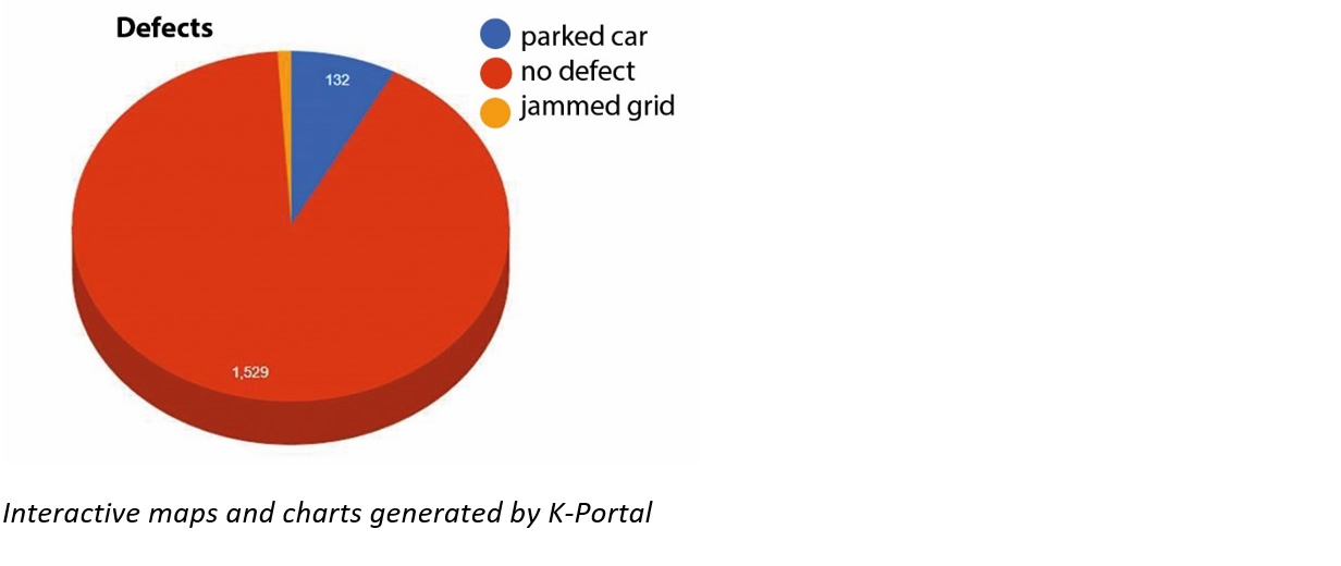
In particular, users of our Mobile Mapping service for large projects can use our K-Portal to monitor work on a minute by minute basis through a ‘breadcrumb’ trail and this useful information can be used in interactive charts, for example, just click on a segment to view the location of all recorded defects. This means information can be acted on immediately.
KOREC Opinion – More and more KOREC customers are asking for customised solutions that include our K-Portal hosted, cloud based solution for the live monitoring of projects, live analysis and the issuing of work orders. In fact, we have one customer that, via the cloud, remotely manages its operations on the other side of the world! And of course, as data becomes viewed by more shareholders, the quality of the end product or deliverable, whether it be a report or a plan, will become even more important.
‘Geospatial’ is everywhere
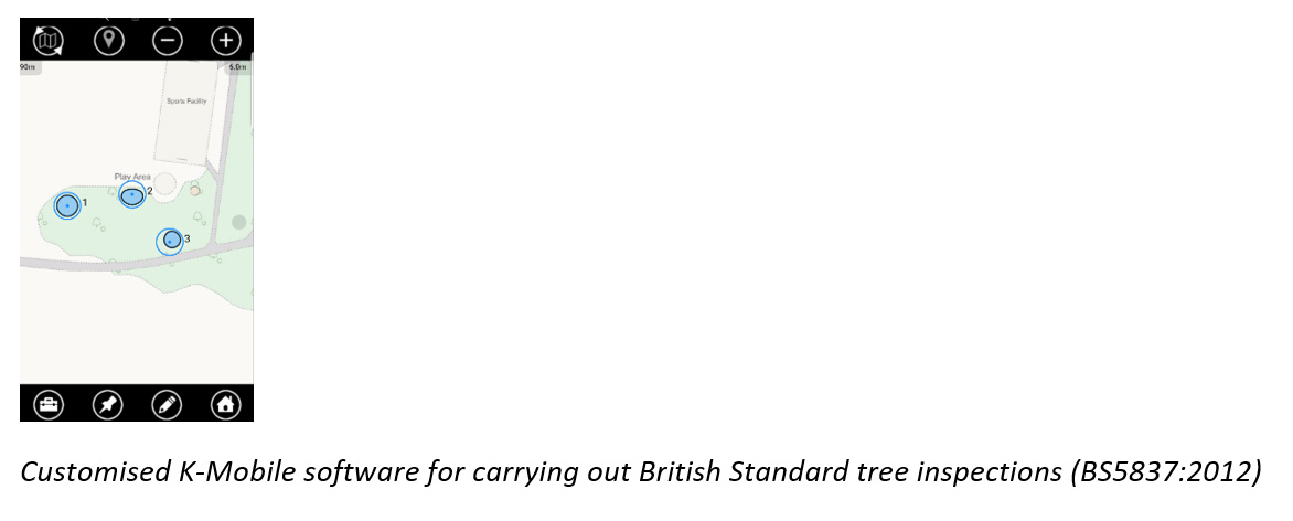
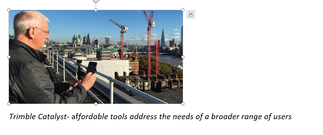
Thanks to the rise of the Smartphone, field software such as K-Mobile (running on both Windows and Android), and of course Trimble Catalyst, the industry’s first software, low cost, subscription based GPS, affordable cm positioning is now available to everyone. The arrival of Trimble Catalyst, a simple ‘plug and play’ system means that accurate data collection is no longer reliant on a full understanding of coordinate systems, geodetic datums and correction sources.
KOREC Opinion – Unlimited growth outside of our traditional customer base. The affordable tools are all in place to address the needs of a broader range of users, particularly those for whom accurate, positional data is important but still secondary to their line of work.
A new age of entrepreneurs
We are entering the Fourth Industrial Revolution, one that will be driven by A1, Big Data, IoT, Robotics and Cloud Computing. The rate of innovation is likely to be fast because our world has greater connectivity than ever before. Consequently, we will see a new generation of thinkers, those who have grown up with Smartphones and the cloud, who will be better equipped to push the boundaries of the geospatial industry from both inside and outside and use positional information in ways that, as yet, we can’t even imagine!
KOREC Opinion – We are already seeing signs of this through the Ordnance Survey’s Geovation initiative. Based in London ‘The Hub’ is a data lab for creative people who want to experiment with property and location information and technology. It is also the recipient of a number of free Trimble Catalyst Licenses to further assist innovative use of high accuracy positioning. Exciting project at the hub are combining Catalyst, robotics and AI. Watch this space!
Alex Wrottesley, Head of Geovation, commented: “Location is at the heart of all new technology propositions. In a world where smartphone use is ubiquitous every interaction can be connected to location-data and intent. At Geovation we work with hundreds of entrepreneurs and startups looking at opportunities in almost every sector – property, infrastructure, connectivity, transportation and wellness to name a few. We can’t wait to see that the next generation of businesses can do with the technologies that are now available to them”.
In conclusion, we can’t begin to imagine what our customer database will look like 10 years from now but we are preparing for a customer that is well versed in the benefits of Big Data, AI, Robotics, Cloud technology, Customised Workflows and subscription based services.
*We’re not the only ones to share our views on the market. Over 50 geospatial industry leaders have been sharing their thoughts and opinions in the Geospatial World Leaders’ Outlook report. It’s well worth a read.