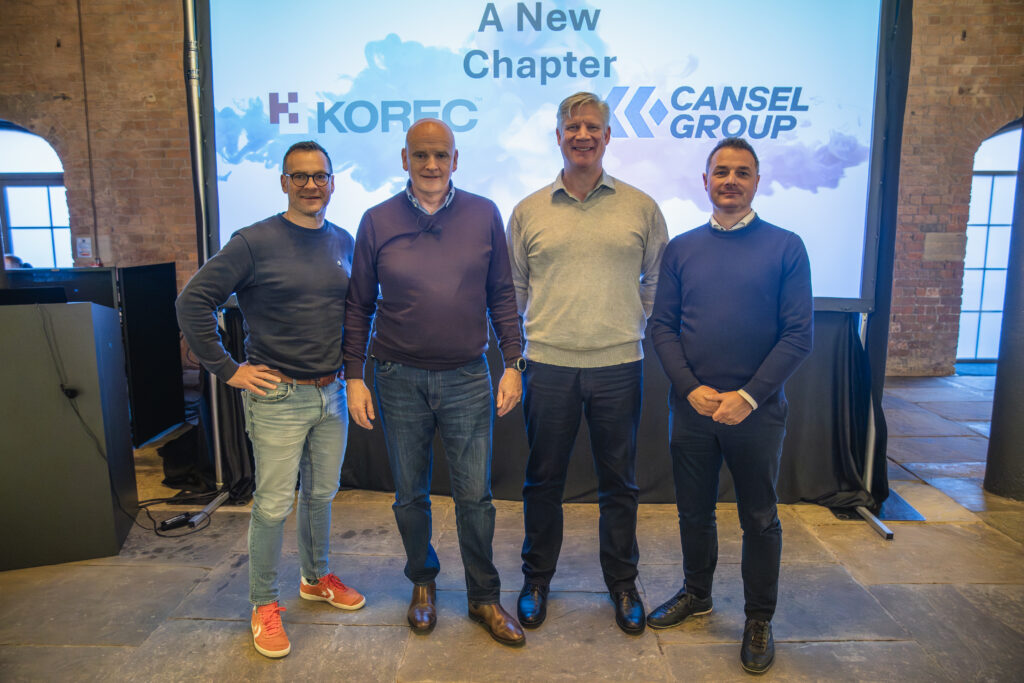
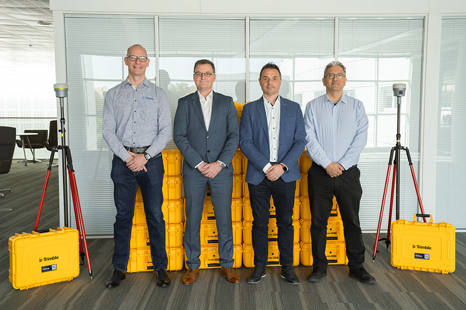
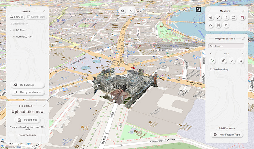
As a result of their recent successful integration into Cansel Group, KOREC Group and Survey Solutions Group (SSG) are pleased to announce that both companies are now authorised Propeller distributors covering the UK, Scotland and Ireland.
The two companies will sell and support Propeller’s leading cloud-based platform for drone mapping, 3D site analytics and earthworks management.
KOREC and SSG customers will have a proven solution for processing and analysing drone data across a range of applications including surveying, mapping, construction, housebuilding, aggregates, mining and waste management. The Propeller distributorship will also enable KOREC and SSG to expand into the BYOD (bring your own data) market.
Compatible with all the major UAVs sold by both KOREC and SSG, Propeller can also be fully integrated into the Trimble eco-system via the Trimble Connect common data environment.
Benoit Mallen, President UK and Ireland, Cansel Group said:
“At Cansel, with KOREC Group and Survey Solutions Group now fully integrated, we’re committed to delivering user-friendly field-to-finish workflows. The Propeller agreement brings their leading cloud-based drone mapping, 3D analytics, and earthworks platform to customers across the UK, Scotland, and Ireland enabling faster, more actionable insights from drone data in surveying, construction, aggregates, mining, waste management, and more.”
Sam Long, Account Executive, Propeller Aero said:
“We’re excited to welcome KOREC and SSG as new distributions for Propeller Aero. KOREC and SSG have built an outstanding reputation within the geospatial industry, and their expertise and strong relationships across the sector make them a natural fit for Propeller. Since they already provide many of the survey-grade drones our customers rely on, this partnership makes it easier for surveyors to process drone data, reduce photogrammetry workloads and share accurate site insights with teams across the business. We’re really looking forward to bringing the Propeller platform to KOREC and SSG’s customers and helping them unlock the value of accurate aerial data and streamlined site workflows.”
For more information or to arrange a demonstration, please contact www.korecgroup.com/contact or www.surveysolutionsgroup.co.uk
Propeller will be attending KOREC’s upcoming UAV days in March and April with further dates in Scotland to be announced by SSG.
Download a PDF of the release here
About KOREC Group
KOREC Group specialises in the provision of intuitive software and world lead positioning technology for the measurement, mapping and management of the natural and built environment.
KOREC is the UK and Irish distributor for Trimble and operates nationwide out of offices in Huntingdon, Liverpool, Dublin and Craigavon (NI). .In December 2025, KOREC joined the Cansel Group, a respected leader in geospatial technology with established operations across Canada and North America. www.canselgroup.com www.korecgroup.com
About Survey Solutions Group
Established in 1993, Survey Solutions Group provides high quality survey systems, for sale or hire, backed up by its service and repair centre, technical support and training service.
In 2001 it became the only authorised Trimble distributor in Scotland for all Geospatial solutions and in 2025 joined the Cansel Group, a respected leader in geospatial technology with established operations across Canada and North America. www.canselgroup.com http://www.surveysolutionsgroup.co.uk/
About Propeller
Propeller Aero is a leading global provider of cloud-based drone mapping, 3D site analytics and earthworks management solutions. Founded in 2014 in Sydney, the company has grown from a startup into a trusted industry player with offices in Denver, Manila, and Amsterdam. www.propelleraero.com
Liverpool & Dublin, UK – 17th December 2025. KOREC Group, a trusted provider of geospatial technologies in the UK and Ireland, is pleased to announce that it is joining the Cansel Group, a respected leader in geospatial technology with established operations across North America. This acquisition marks an important milestone in both KOREC’s journey to offer the very best solutions and service to its customers, and Cansel Group’s strategy to expand its international footprint and enhance its position within the global Trimble distribution network.
KOREC’s history dates back to 1967 a family-run business in Liverpool, providing precision tools and instruments to construction professionals. KOREC is now recognised as one of Trimble’s largest distributors worldwide, in addition to representing other industry-leading brands, supporting surveying, construction, GIS and mapping, monitoring, rail, utilities, highways, and forensics.
“Joining the Cansel Group is an exciting milestone for us,” said Mark Poveda, Managing Director of KOREC Group. “From our first talks with Cansel it was clear that their team ethos and way of working is aligned to our culture and how we support our customers. Our long history, technical expertise, and strong partnership with Trimble fit well with Cansel’s strategy to expand its international footprint and strengthen its position within Trimble’s global distribution network. As we join this broader group, our customers can expect the same great service from the same customer-focused teams, enhanced by the additional resources and stability this partnership brings. I’m sure I speak for everyone at KOREC when I say we look forward to working with the Cansel team to continue to empower our customers to work smarter.”
“Bringing KOREC into the Cansel Group is a powerful step forward,” said Martin Trudelle, President & CEO of Cansel Group. “KOREC shares our commitment to excellence, innovation, and delivering meaningful value to customers. Their culture, expertise, and vision align perfectly with ours, making this partnership both strategic and natural.”
“Our vision is grounded in strong talent, trusted partnerships, and solutions that meaningfully improve productivity and profitability for our clients,” added Martin Trudelle. “The addition of KOREC brings us closer to achieving that vision.”
KOREC Group’s customers can expect continuity in their day-to-day experience, as local teams and service levels will remain unchanged. Over time, they will also benefit from the broader resources, expertise, and stability of the Cansel Group, as well as expanded access to innovative technologies and strengthened partnerships with Trimble and other key suppliers. KOREC will operate as a wholly owned subsidiary of Cansel Group, joining an international network that including Cansel Surveying Equipment (Canada), CSDS (California), and Survey Solutions Group (Scotland). Both KOREC and Cansel Group look forward to embarking on this exciting next chapter of shared growth.
About KOREC Group
KOREC is a leading provider of technology solutions to measure, map, and manage the natural and built environment. The company employs approximately 120 people and its partnership with Trimble, launched in 1997, remains central to its success. KOREC now partners with other software and hardware providers, supporting markets that align closely with Cansel Group.
About Cansel Group
Cansel Group provides innovative solutions, unparalleled technical expertise, and personalized client experience across North America and now in Europe. The group is composed of Cansel Survey Equipment (Canada), BuildingPoint (Canada), CSDS (California), Survey Solutions Group (Scotland), and now KOREC Group (UK & Ireland).
For customer/supplier enquiries, please reach out to your normal KOREC representative. For press enquiries, please contact marketing@korecgroup.com
KOREC Group is delighted to announce a new partnership with Worldsensing that will see KOREC supply and support Worldsensing’s Loadsensing devices directly, rather than through the Trimble brand.
By working directly with Worldsensing, KOREC will be able to offer customers monitoring expertise based on a full understanding of their project and integration requirements, backed up by a fast turnaround on Worldsensing’s Loadsensing devices.
This new collaboration places KOREC in a stronger position to meet the time pressured needs of the monitoring market and deliver greater value to customers.
Trimble remains fully committed to the monitoring industry and to T4D Control as the central software for a complete monitoring solution.
Ric Kirman, UK & Ireland Business Area Manager Rail & Monitoring, KOREC, said:
“In an industry that can impose extremely tight deadlines, our new partnership with Worldsensing means KOREC customers will benefit from significantly faster response times across the board – from expert consultancy and system-design advice to seamless integration and supply of the right equipment. This streamlined approach ensures we can react swiftly and deliver robust monitoring solutions exactly when they’re needed.”
Arnau Carbonell, Worldsensing EMEA Sales Director said:
“By uniting technological and industry expertise, this partnership with KOREC Group expands the boundaries of what’s achievable and sets a new standard for innovation and connectivity in geotechnical and construction monitoring.”
About KOREC Group
KOREC Group specialises in the provision of intuitive software and world lead positioning technology for the measurement, mapping and management of the natural and built environment.
KOREC is the UK and Irish distributor for Trimble (www.trimble.com) and operates nationwide out of offices in Huntingdon, Liverpool, Dublin and Craigavon (NI). www.korecgroup.com
About Worldsensing
Worldsensing is a global IoT pioneer. Founded in 2008, the infrastructure monitoring expert serves clients in more than 70 countries, with a network of global partners to jointly drive safety in mining, construction, rail and structural health.
Worldsensing is headquartered in Barcelona and has a local presence in the UK, North and South America, Singapore and Australia.
ENDS
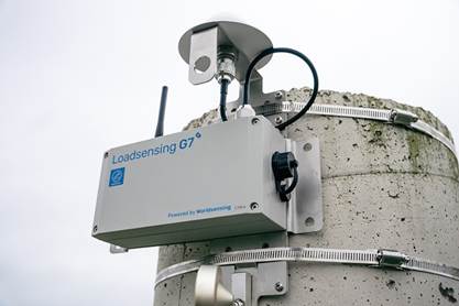
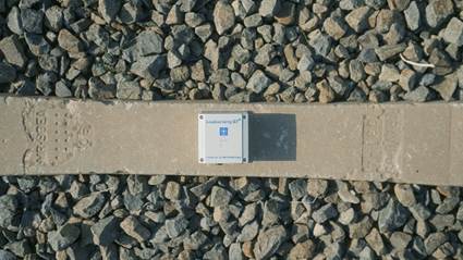
Products from the Worldsensing range that will be supplied directly by KOREC
KOREC is delighted to announce that it has signed a reseller agreement with Terrasolid to sell the company’s software which is widely recognised as the industry standard for LiDAR and image data processing.
The agreement is for the UK and Ireland and covers the main Terrasolid product suite including TerraScan, TerraModeler, TerraPhoto, TerraMatch, TerraStereo and TerraBatch as well as UAV and Lite versions.
Developed specifically to meet the demanding requirements of geospatial, engineering, and environmental professionals, Terrasolid’s software provides the versatile tools needed to create everything from 3D vector models and feature extractions to orthophotos and advanced point cloud visualisations, regardless of data source or sensor.
This agreement reinforces KOREC’s position as a one-stop solution provider – hardware, software, and support & training – and enhances the company’s ability to deliver complete end-to-end workflows for 3D data capture, processing, and analysis.
“For 25 years Terrasolid has been the industry standard for processing LIDAR data from dynamic laser scanning solutions including Mobile Mapping, UAV, fixed wing, and handheld SLAM,” said Mark Reid, UK Sales Director at KOREC. “The software is agnostic and complements our existing portfolio to help customers efficiently process and extract value from their captured datasets with even greater accuracy and efficiency.”
“For Terrasolid, the partnership with KOREC represents strengthened access to a key geospatial market,” said Xabier Eraña, VP Sales at Terrasolid. “With KOREC’s deep reach into surveying, mapping and infrastructure sectors in the UK & Ireland, Terrasolid is better positioned to deliver its 3D reality-capture software to critical industry workflows.”
For more information or to arrange a demonstration, please visit www.korecgroup.com/contact
ENDS
About KOREC Group
KOREC Group specialises in the provision of intuitive software and world lead positioning technology for the measurement, mapping and management of the natural and built environment.
KOREC is the UK and Irish distributor for Trimble (www.trimble.com) and operates nationwide out of offices in Huntingdon, Liverpool, Dublin and Craigavon (NI). www.korecgroup.com
About Terrasolid
Terrasolid develops world-leading software solutions for processing 3D point clouds and imagery collected from airborne, mobile, and terrestrial sensors. Based in Finland, Terrasolid’s applications are trusted by mapping professionals and engineers in over 100 countries. www.terrasolid.com
PRODUCT SPOTLIGHT
Discover TerraScan
TerraScan from Terrasolid is the industry standard for managing and processing point clouds – a reputation its held for over 25 years. TerraScan is the main app in the Terrasolid software suite, designed to make it easy for you to manage, process and visualise point cloud data. Deliverables include high quality classified point cloud data or vector data to be used in various engineering and maintenance applications.


New Wingtra-Trimble partnership brings seamless data integration for KOREC drone customers
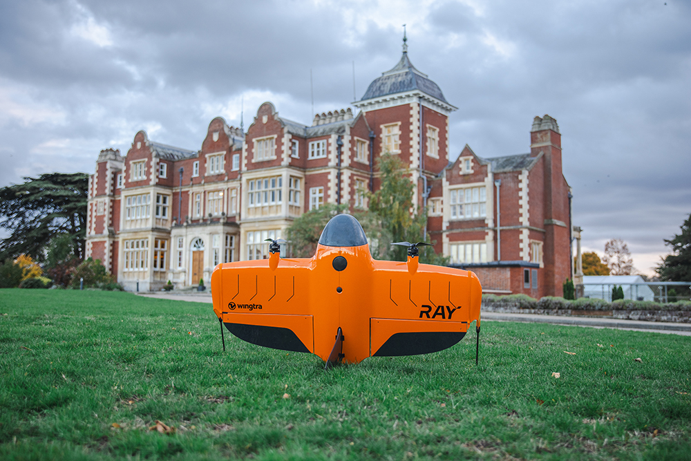
The WingtaRAY at the KOREC Trimble User Conference held in Cambridge in October (KTUC 2025)
KOREC is delighted to announce that a new partnership between Wingtra and Trimble will deliver tighter integration between Wingtra’s industry-leading drone solutions and Trimble’s world-class survey and mapping workflows.
Delivering a smarter way to get high-quality data, the joining of these powerful Trimble and Wingta survey tools will cut field time, minimise manual work and ensure users achieve accurate, actionable results far faster.
Available now is Trimble-native file support in WingtraCLOUD enabling quick drag-and-drop compatibility. This will enable KOREC customers to create survey sites instantly by uploading Trimble Business Center export files in .JXL (no manual setup), Skip RINEX conversions (just drag and drop your TO2/TO4 files) and work faster in local coordinate systems with fewer errors
Coming in 2026 is Wingtra’s cm-level positioning powered by Trimble correction services with no need for a base station. Users will be able to automatically apply cm-accurate corrections in WingtraCLOUD and establish known points globally with PPP support. Plus users will also have the ability to sync and export maps directly from WingtraCLOUD to Trimble Connect and TBC.
Future data connectivity will be ongoing throughout 2026 with tighter Trimble + Wingtra hardware/software integrations ensuring data flows from flight to final deliverable, without interruptions.
John Cartlege, Mapping & GIS Business Area Manager, KOREC said:
“Trimble leads in precision positioning, data integration and advanced GNSS solutions, Wingtra drives innovation in aerial mapping with its WingtraRAY VTOL drone technology and KOREC champions emerging technologies, bringing these innovations to our UK and Irish customers through our local expertise, support, and consultancy.
“We look forward to doing what we do best – helping KOREC customers seamlessly integrate these solutions into their workflows for greater efficiency accuracy and value.”
For more information or to arrange a demonstration, contact the KOREC Mapping Team at on0345 603 1214or visit www.korecgroup.com/contact
ENDS
KOREC is delighted to announce that following a successful tender, it is supplying Ordnance Survey (OS) with one hundred and eighty Trimble R980 GNSS Receivers. These receivers will be supported by KOREC for the duration of the five-year contract.
Download a PDF of the press release here
From left to right: Chris Harris (Channel Sales Manager, Field Systems EMEA, Trimble), Michael McEvoy (Principal Production Consultant, Ordnance Survey), Mark Poveda (Managing Director – UK & Ireland, KOREC Group) and Cesar Almeida (Senior Applications Engineer, KOREC Group)
The OS move to Trimble UK distributor, KOREC, has been based on both the advanced performance and productivity that the top-tier Trimble R980 Receivers can deliver, and their easy integration with OS’s existing data collection and handling software, the Esri suite of ArcGIS products.
The R980 Receivers brings together several top Trimble GNSS technologies and are particularly suitable for OS through features such as Trimble CenterPoint® RTX corrections for RTK level accuracy worldwide delivered via satellite or internet, without the need for a local base station or VRS network.
Mark Poveda, Managing Director – UK & Ireland, KOREC Group said:
“We’re extremely proud to be supporting Ordnance Survey with the supply of Trimble R980 GNSS Receivers following a successful tender. This significant contract reflects not only the performance and reliability of Trimble’s leading-edge GNSS technology, but also the confidence that OS has placed in KOREC as a long-term technology partner. We look forward to supporting OS over the next five years and ensuring their teams have the tools they need to maintain the highest mapping standards.”
Michael McEvoy, Principal Production Consultant, Ordnance Survey said:
“Ordnance Survey is pivotal in supporting the government, businesses, and individuals by maintaining and updating the digital master map of Britain with 20,000 changes a day. Our field surveyors therefore need a modern, robust, and accurate GNSS system to assist with the capture of our data which will serve them effectively now and into the future. The KOREC Group has provided OS with a great solution that integrates into our existing production environment. It will also enable our surveyors to use new technologies and capture tools to improve efficiency, whilst other features will enable work in remote areas, reliably and to high precision.”
From left to right: Michael McEvoy (Principal Production Consultant, Ordnance Survey) and Mark Poveda (Managing Director – UK & Ireland, KOREC Group)
About KOREC Group
KOREC’s mission is to empower you to measure, map and manage the natural and built environment.
Combining industry knowledge, with intuitive software, and world-leading positioning technology, KOREC transforms your operations bringing certainty to your decision making.
About Ordnance Survey
Ordnance Survey (OS) is Great Britain’s national mapping service. We carry out the official surveying of Great Britain (GB), providing the most accurate and up-to-date geographic data, relied on by government, business, and individuals.
KOREC Group is pleased to announce that it has been appointed as the exclusive channel partner in the UK and Ireland for Exyn Technologies, a leading US specialist in autonomous robotics and data collection
KOREC’s focus will lie with the company’s latest 3D mapping solution, the recently released Exyn Nexys. Modular in design, this system can be used as a handheld device as well as an attachment to a drone, ground robot, vehicle, or backpack.
The Nexys is equipped with a LiDAR scanner and Exyn’s proprietary SLAM algorithms, delivering exceptional capture speeds of up to 1.9 million scan points per second, alongside real-time point cloud colourisation.
The system can also navigate autonomously in GNSS-denied environments, featuring what Exyn defines as Autonomy Level 4 capabilities. At this level, drones and robots can explore and map unknown spaces completely independentlyeliminating the need for human intervention.
The introduction of the Nexys range, which includes both standard and Pro models, further strengthens KOREC’s portfolio of mobile mapping systems. This expansion ensures that KOREC continues to meet the growing demand for accurate, easily captured point cloud data with workflows relevant to the UK and Irish markets.
Additional Nexys features include direct export into Trimble Reality Cloud Platform Service (TRCPS), integration of Trimble GNSS solutions for precise georeferencing, adjustment to ground control meaning no drift, real time colourisation and advanced dust filtering.
Mark Poveda, Managing Director – UK & Ireland, KOREC Group said:
“Exyn recognises KOREC as a trusted partner with decades of experience in delivering customer-focused solutions shaped by invaluable feedback. With our strong mutual alignment with Trimble, this partnership is a perfect fit, ensuring that Exyn’s cutting-edge US technology is introduced to the UK and Irish markets by a local expert who understands their customer’s real-world challenges faced on site every day.”
Brandon Torres Declet, CEO at Exyn Technologies said:
“We are thrilled to welcome KOREC Group as our first UK and Irish-based partner. Their commitment to empowering industries to measure, map, and manage the natural and built environment aligns perfectly with our mission. We’re excited to collaborate with a like-minded partner to bring Exyn’s cutting-edge autonomous technology to the UK market.”
About Exyn
Founded in 2014 with headquarters in Philadelphia, Exyn Technologies is pioneering autonomous aerial robot systems for complex, GNSS-denied environments. The company’s full-stack solution enables flexible deployment of single or multi-robots that can intelligently navigate and dynamically adapt to complex environments in real-time.
Download a PDF of this press release here
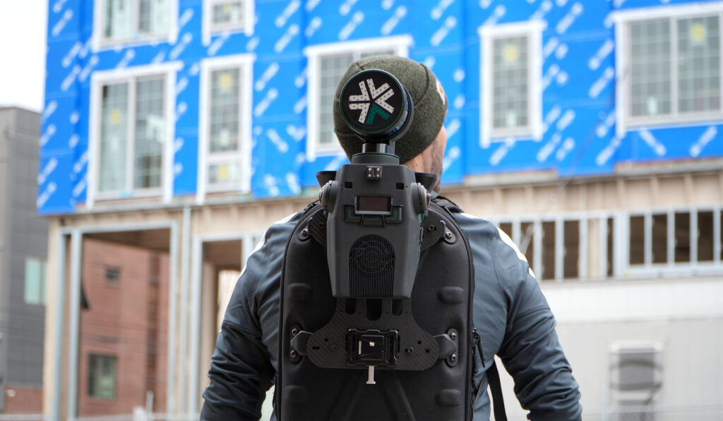
Nexys is a modular system and can be used as a handheld device as well as an attachment to a drone, ground robot, vehicle, or backpack
03/03/2025
KOREC Group announces new distributor agreement with Soarvo
KOREC Group is delighted to announce that it has been named as the official distribution partner in the UK and Ireland for Soarvo.
Soarvo is a new cloud-based geospatial data platform for surveyors, drone operators, and mapping specialists. It is designed for seamless data visualisation and sharing, supporting a wide variety of sources and file formats, all hosted in one place.
This strategic move enables KOREC to bring Soarvo to the geospatial professionals who need it most—those seeking a platform capable of handling and sharing the high-quality, dense datasets captured by industry-leading sensors such as drones, mobile mapping systems and 3D laser scanners.
Eliminating the need for expensive, complex hardware and software, Soarvo presents this data in a rich, multilayered 3D geographic environment.
Mark Poveda, Managing Director – UK & Ireland, KOREC Group said:
“Partnering with Soarvo is a strategic move that complements our mission to provide top-tier geospatial solutions. We are confident that this partnership will drive mutual growth and deliver exceptional results for our customers.”
Alan Browne, CEO and Co Founder – Soarvo said:
“This collaboration with KOREC will help Soarvo maximise its impact within the geospatial community. KOREC’s expertise and support will enhance the overall customer experience, ensuring that users receive the full benefits of Soarvo’s innovative 3D geospatial platform.”
About Soarvo
Founded by Alan Browne and Paul Brodin—an engineer and a software developer with decades of geospatial experience—Soarvo is all about making geospatial data management simple and accessible for professionals and their customers across various industries.
The Soarvo team has been built to deliver innovative geospatial data solutions that help users unlock the potential of their geospatial data and enhance collaboration for a more connected world. Soarvo is on a journey to turn geospatial data into actionable insights, optimising real-world outcomes for businesses and communities alike.
Request a demo at www.soarvo.com
Soarvo provides context around your dataset and positions it in the real world on a choice of background map data
Download a PDF of the release here
KOREC Group is delighted to announce that it has become a top level, Tier 1 reseller for DJI’s Enterprise drones through an agreement with Midwich Ltd, a key distributor of DJI Enterprise’s drone solutions in the UK and Ireland.
This new agreement will see KOREC further expanding its drone and UAV portfolio which already includes Wingtra, Parrot and AgEagle products.
The DJI Enterprise range, including Matrice and Mavic rotary drones as well as Dock solutions, will provide KOREC geospatial customers with a comprehensive, one-stop solution. This offering combines cutting-edge products with certified pilot training, technical support & consultancy, processing software and cost-effective GNSS technology for establishing ground control points (GCPs), all backed up by KOREC’s T.R.U.S.T. brand promise.
John Cartledge, Mapping & GIS Business Area Manager, KOREC Group said:
“We are delighted to achieve Tier 1 status, the highest grade of partnership with DJI, and to bring their innovative portfolio to these markets. Our mapping and GIS team has undergone rigorous technical and product training to meet DJI’s exacting standards.
With our proven ability to provide end-to-end solutions for drone operators and service providers — including pilot training, processing software, and GPS control (Catalyst) — we deliver everything needed for imagery, thermal, multi-spectral, and LiDAR applications. Whether tackling small-scale or large-scale projects, KOREC is equipped to meet every requirement.”
Adam Box, Sales Manager (Drones and UAV) for Midwich Ltd said:
“We are delighted to announce that KOREC Group has officially joined the DJI Enterprise family as a reseller, further strengthening our dealer channel at Midwich Ltd.
With their extensive expertise in geospatial solutions and commitment to delivering cutting-edge technology, KOREC Group is perfectly positioned to represent DJI Enterprise’s innovative drone solutions. This partnership marks an exciting step forward in expanding the reach and support for DJI Enterprise across the UK and Ireland.”
To learn more about DJI Enterprise drones, look out for details on our upcoming launch event and webinar or contact us now
We’re delighted to announce that KOREC’s new Mapping and GIS Business Manager is one of the best-known names in the industry, and with over 30 years of experience, he most definitely lives and breathes all things geospatial!
The KOREC Mapping team from left to right: Darrell Theobalds (Geospatial Technical Support – MGIS), Rob Partridge (MGIS Customer Success Manager), Nadia Oliveira (MGIS Account Manager) and John Cartledge (Mapping and GIS Business Manager).
Starting his careers with a degree in civil engineering, most people will know John Cartledge from his two decades at Ordnance Survey where he undertook a number of positions that saw him working in consultancy, commercial sales, operations, project management and development roles. He therefore has an extremely strong understanding of the unique business challenges that KOREC’s mapping customers face whether they be geospatial professionals introducing new workflows or those working in other industries with a requirement for high accuracy positioning.
Based on his 30 years within the industry, John brings with him four core beliefs, all of which align seamlessly with KOREC’s capabilities:
- Problems are there to be solved: The KOREC mapping team boasts extensive experience across diverse markets and is adept at understanding the different needs of all stakeholders involved in a project. In particular, KOREC and John have been in the mapping GPS business for the same length of time – since the beginning!
- A new workflow isn’t about wholesale change: We understand that whilst it’s all about the end data, organisations seek this result with the least disruption to their business. Just one of KOREC’s specialist areas is digitising existing workflows, another one is working with what you’ve got whether that be existing software or hardware. Compatibility is key!
- Value for money is a key customer requirement: The business case is the first step in any new project and the numbers have to add up – Trimble’s Catalyst system, a subscription GNSS with cm accuracy is one of KOREC’s most workable solutions.
- You’re never just buying a product, you’re also buying into the company’s ethos: When you work with KOREC, you can rest assured that you’re in good hands because every day, we strive to meet our five principles of TRUST; Transparent, Reliable, Understanding, Supportive and Timely. We also have a Technical Support team that’s consistently mentioned for its performance in going ‘above and beyond’
John can be contacted at john.cartledge@korecgroup.com or on +44 (0) 7870 894151