The latest issue of Mensura is now available to download here.
Mensura is KOREC’s quarterly geospatial newsletter packed full of news, new releases, training tips, case studies and competitions. If you’d like to receive a printed copy, please drop us an email at marketing@korecgroup.com and we’ll add you to our Mensura mailing list.

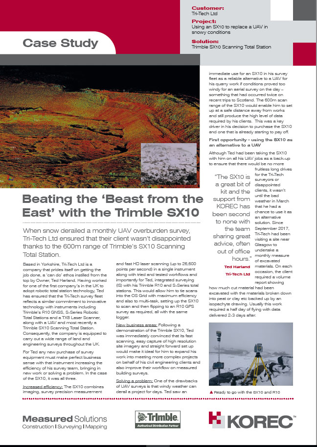
Remember ‘The Beast from the East’? Last month’s snow has provided us with a great case study from Tri-Tech Ltd who used their SX10 instead of their usual UAV for an overburden survey in Scotland. Many thanks to Tri-Tech Ltd Owner Ted Harland for sharing the informatioin and pictures.
Download the PDF here.
K-Mobile Updates
Progress never stands still and neither does KOREC’s K-Mobile mapping/data capture software development team! Here’s a round-up of what they’ve been working on over the past few weeks:
Android Bluetooth link to laser rangefinders
It’s been available in the Windows version of K-Mobile for a while and now we’ve added this useful function to the Android version too. Suitable for any Bluetooth enabled laser, its perfect for ensuring your offset measurements (eg shooting to points in inaccessible areas or GPS blackspots) or height and width measurements (ideal for tree surveys) are recorded directly into your data entry form.
Live Portal Update
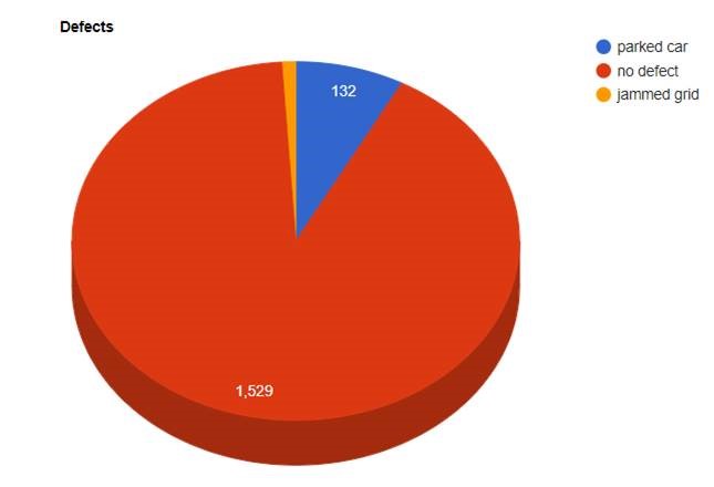
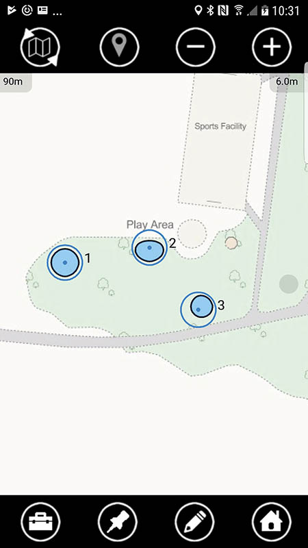
Imagine you are cleaning gullies or checking street furniture. Permitted office users can now log into the secure K-Mobile portal and track a service vehicle through a ‘bread crumb’ trail watching dots turn from red to blue as work is completed. Updates occur once a minute and this useful information can be used to illustrate all work done in a day or even show live dashboards, for example as an interactive pie chart. Simply click on a segment to view the location of recorded defects etc bringing live analysis to your data collection projects.
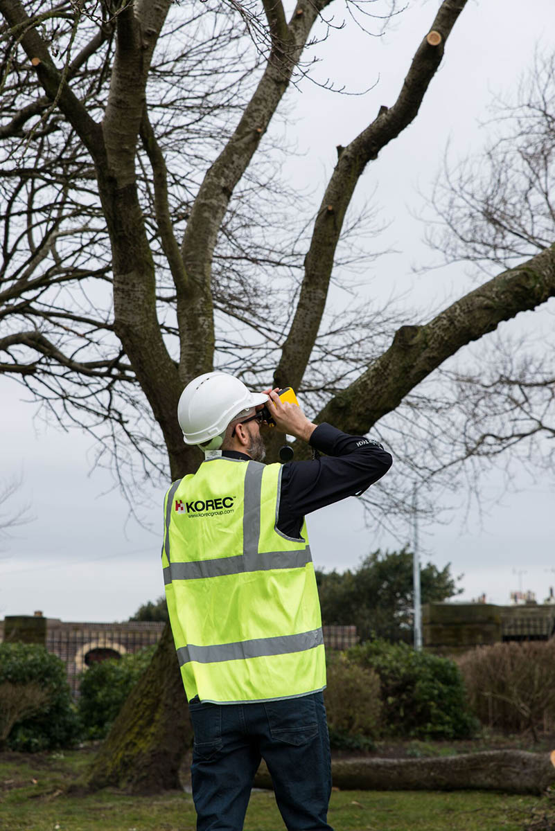
New product – K-Mobile Tree Edition
All the functionality of our fully featured K-Mobile data capture software with extra built-in tree functionality and visualisation tools. Perfect for undertaking British Standard tree surveys, key benefits include live graphic representation of tree canopy measured in four directions (N,S,E,W) and calculations and graphic representation of root radius. Also visible back in the office via the Live Portal. We have a new case study on exactly this application at http://bit.ly/2FRtMRb
Combining a high level of technical nous with a user-friendly delivery (Eugen is a part time lecturer at the acclaimed Dublin Institute of Technology) our new KOREC Geospatial Sales Consultant also brings extensive practical experience to the team, having worked on site in a range of survey disciplines as well as at the sharp end of Murphy Surveys as a former Quality and Technical Manager specialising in site and office workflows.
A renowned Chartered Geomatics Surveyor, Eugen is a professional member of the Society of Chartered Surveyors Ireland (SCSI) and the Royal Institution of Chartered Surveyors (RICS). Elected member of the Geomatics Professional Group in SCSI from 2011 to 2013 and from 2015 to present, where he adapted the RICS’s “Scale” and “Map Projections and Scale Factors” client guides for SCSI and wrote “OSGM15 – Geoid Changes for Ireland” SCSI client guide.
Amongst all of this Eugen also volunteers his time with Coder Dojo, a global network of free computer programming clubs for young people. When he does get any spare time, he enjoys a spot of swimming.
We are excited and proud to have Eugen on board with us at KOREC as a Geospatial Solutions Consultant in Dublin, Ireland. We are sure that with all his knowledge and experience, he will be a great asset to KOREC and our customers.
Welcome to KOREC Group team, Eugen!
X Marks the Spot
As with all good adventure trails X usually marks the spot of hidden treasure. Well, we’re pleased to tell you that we’ve got a real spot of treasure in store.
KOREC are giving 7 lucky followers the chance to win an all expense paid trip to Stockholm for a Trimble SX10 Factory Tour in Danderyd, Sweden on the 12th and 13th June 2018.
How can you get your hand on a ticket we hear you ask? Well it’s very simple really. Send us a picture or short video of your Trimble equipment being used in a tough or unusual environment. The best image / video wins.
You have until April 26th to send us your entries. Just email us at marketing@korecgroup.com
We’ve also got lots of other ways you can win a ticket. Keep an eye on our socials for further details.
The February issue of CES magazine sees the publication of the full version of Alan Browne’s article on instrument theft and its consequences. This is a problem that is blighting our industry and its good to see it highlighted in CES.
Read Alan’s full article here
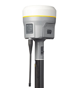
Since its launch in 2012 the R10 has proved to be one of KOREC’s best selling products. It’s generated more KOREC case studies than any other Trimble instrument and provided us with a CES magazine front cover photograph that became recognisable across the world.
But what do KOREC customers value most about their Trimble R10’s performance? Of course there are honourable mentions for all the R10’s patented technologies including:
• Trimble CenterPoint RTX delivering GNSS corrections via satellite or internet connection with unprecedented speed and accuracy for a PPP solution
• Trimble xFill ensuring less downtime in the field, with continuous RTK coverage during connection outages from an RTK base station or VRS network
• Trimble SurePoint fully compensating for pole tilt for the convenient measurement of points that were otherwise inaccessible with complete quality assurance
But coming in at number 1 is the R10’s cutting edge Trimble HD-GNSS processing engine which simply enables surveyors to measure points more quickly!
Here’s why the R10’s HD-GNSS processing engine makes it the industry’s turn to GNSS solution:
Trimble has a strong history of in-house is development which is why we have HD-GNSS, the ‘quiet’ hero of the R10. In keeping with Trimble’s ability to produce systems aimed specifically at the needs of the land surveyor, the HD-GNSS processing engine of the R10 provides markedly reduced convergence times as well as high position and precision reliability when compared to earlier processing engines, especially in poor GNSS environments. Key benefits Trimble HD-GNSS delivers include:
• Increased initialisation speed
• Improved real-time measurement precision
• Elimination of the possibilities of a “bad fix”
• Increased reliability of precision reporting
• Reduced post processing complexity for the user
The R10 is based around the Trimble Maxwell-6 custom integrated circuit technology for GNSS signal processing RTK calculations are performed in the R10 with a microprocessor that has more magnitude and is more powerful than anything before it and also more energy efficient. The shift to this new methodology makes it possible for Trimble to continue to improve performance as GNSS constellations develop.
Fully scaleable through firmware and software updates, HD-GNSS is well positioned to take full advantage of additional GNSS satellites and signals to further improve surveying in increasingly demanding field conditions.
All this is possible because, unlike most other providers of survey grade GNSS, development is in-house and fully under Trimble’s control allowing the company to meet a very specific set of requirements, namely those of the surveyor in the field.
Download the Trimble HD-GNSS white paper for full details or call your regional KOREC survey consultant for a demo.
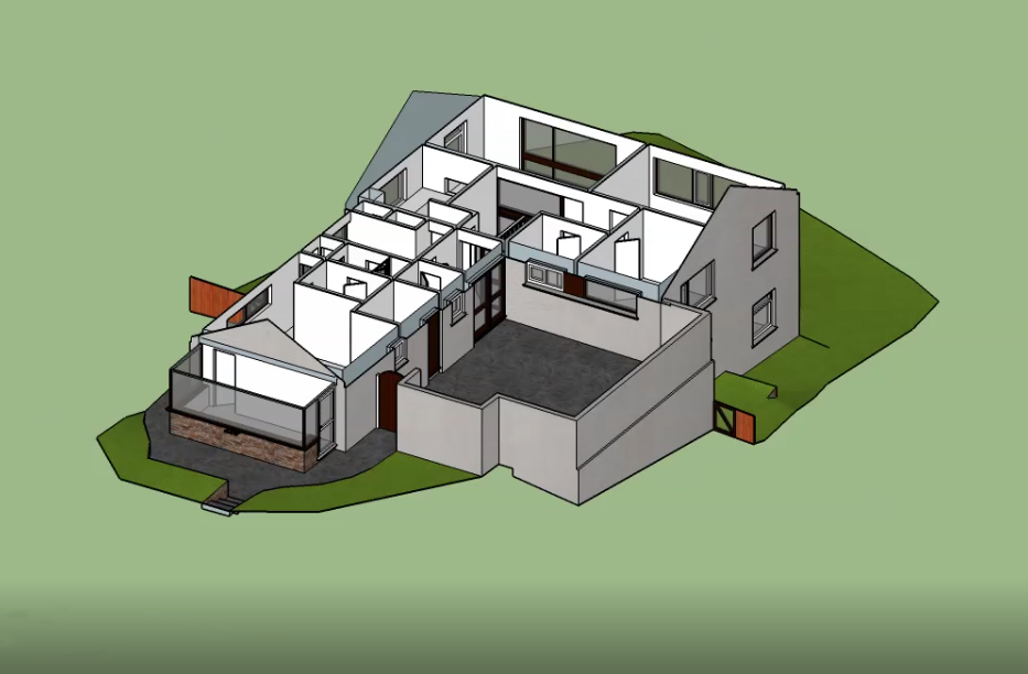
It used to be that registering pointcloud data from a 3D laser scan was a major part of the job and required significant time and effort back in the office. Fortunately, it’s a far simpler process these days, especially with the implementation of software advancements such as Trimble RealWorks which provides cloud to cloud registration, and options for target based registration as well as plane based registration. The advantage of this further automated process is that it provides us with additional time to consider what we do with our 3D scan data rather than how we register it.
One person who has been doing exactly that is Steve Dash, Senior Measured Building Surveyor at SUMO. Having been equipped with, Trimble RealWorks, Trimble SketchUp Pro and Trimble’s Scan Explorer Extension plug-in for some time, Steve has been converting SUMO captured pointcloud data into impressive 3D models, which have provided SUMO’s clients with even better visualisation of their survey data.
“It all started when we were asked by one of our clients to produce a 3D SketchUp model as the final deliverable. Our client was delighted with the result which met their exact requirements. This first project was back in early 2016 and since then we’ve been offering a 3D SketchUp model service as an addition on many of our projects. On completion of the models, we provide the client with a download-link for a SketchUp viewer where they can easily view and share their 3D model”
“We’ve been running this service for some time now and we are still making exciting developments in this area. The great benefits of these SketchUp models are that we also have the floorplan, elevations and can provide as many sections as required. Furthermore, as we continue to provide this quality service, we are aiming to produce a 3D model with all of our 2D drawings as a standard. Our clients have been delighted with the results and we’ve been really impressed with the software’s ease of use. SketchUp Pro is a friendly and forgiving 3D modelling software and whilst it doesn’t provide the same high-level of functionality as some other more expensive modelling packages, it remains a highly operational and cost-effective entry level option for many of our clients which SUMO are happy to provide.
View the videos created by Steve here, here and here

Welcome to the first issue in 2018 of our geospatial newsletter, Mensura. Our front page story features an open letter from KOREC Group CEO, Alan Browne, on the worrying problem of instrument theft. This is a topic that we will be revisiting throughout the year so please do keep us updated on any thoughts you have on the subject.
This issue also takes a look at some of the ‘value added’ benefits of being a KOREC customer. Look out for details on Trimble Dimensions and trips to Trimble’s SX10 factory in Stockholm. We’ll be inviting lucky customers as KOREC guests to both events.
Finally, our case study focuses on Enviroflow Management’s digital capture of gully data on behalf of its client, Calderdale Council using KOREC’s K-Mobile data capture and handling software
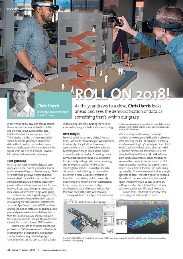
KOREC Regional Business Director has kicked-off the new year with some thoughts on 2018 and the survey industry. In his new look GeoConnexion column Chris looks ahead and sees the democratisation of data as something that’s within our grasp.
Read the piece here
or Download the PDF here