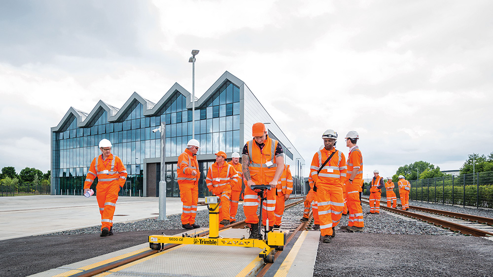
The Doncaster campus of The National College of High Speed Rail (NCHSR) was the location for KOREC’s UK launch of Trimble’s GEDO IMS, a lightweight, flexible and fast system that combines an Inertial Measurement Unit (IMU) with scanning and geodetic sensors for surveying railway lines and documenting assets along the track.
The day was attended by key players from the UK rail industry who all enjoyed presentations and live demonstrations from KOREC and Trimble rail specialists Matthew Lock and Tom Williamson (KOREC) and Matthew Moss (Trimble).
Many of the attendees remained for a tour of the College at the end of the day. NCHSR (Doncaster) was opened in October 2017 by education secretary Justine Greening and was the recipient of a significant gift from Trimble to expand its training and research in railway design, construction and maintenance.
Matthew Lock, KOREC Business Area Manager – Rail and Monitoring, said “The new Trimble GEDO IMU is a fantastic addition to the well-established GEDO family. It offers fast initialisation, high-speed precise measuring and robust construction in a lightweight package. The increased productivity and ease of use, coupled with the fact that it is a single-TMD solution, means our customers take less time on site and do so more safely. We have been really delighted with the response from our customers and look forward to continuing to promote Trimble’s highly productive rail portfolio.”
Clair Mowbray, NCHSR CEO, said, “We are delighted to have been the host venue for KOREC’s UK launch of Trimble’s GEDO IMS and to have welcomed key players from the UK rail industry. Our unique facilities set us apart and we are thrilled we were able to help KOREC demonstrate their new system on the track at the Doncaster campus.”
For further information on Trimble Rail Solutions supplies by KOREC, please contact matthew.lock@korecgroup.com
Can Trimble’s SX10 be a useful alternative to a UAV survey? In the CES June issue, Tri-Tech’s Ted Harland explains how his Trimble SX10 Scanning Total Station saved the day when the ‘Beast from the East’ grounded his UAV.
Read the full story here
Or download the KOREC case study here
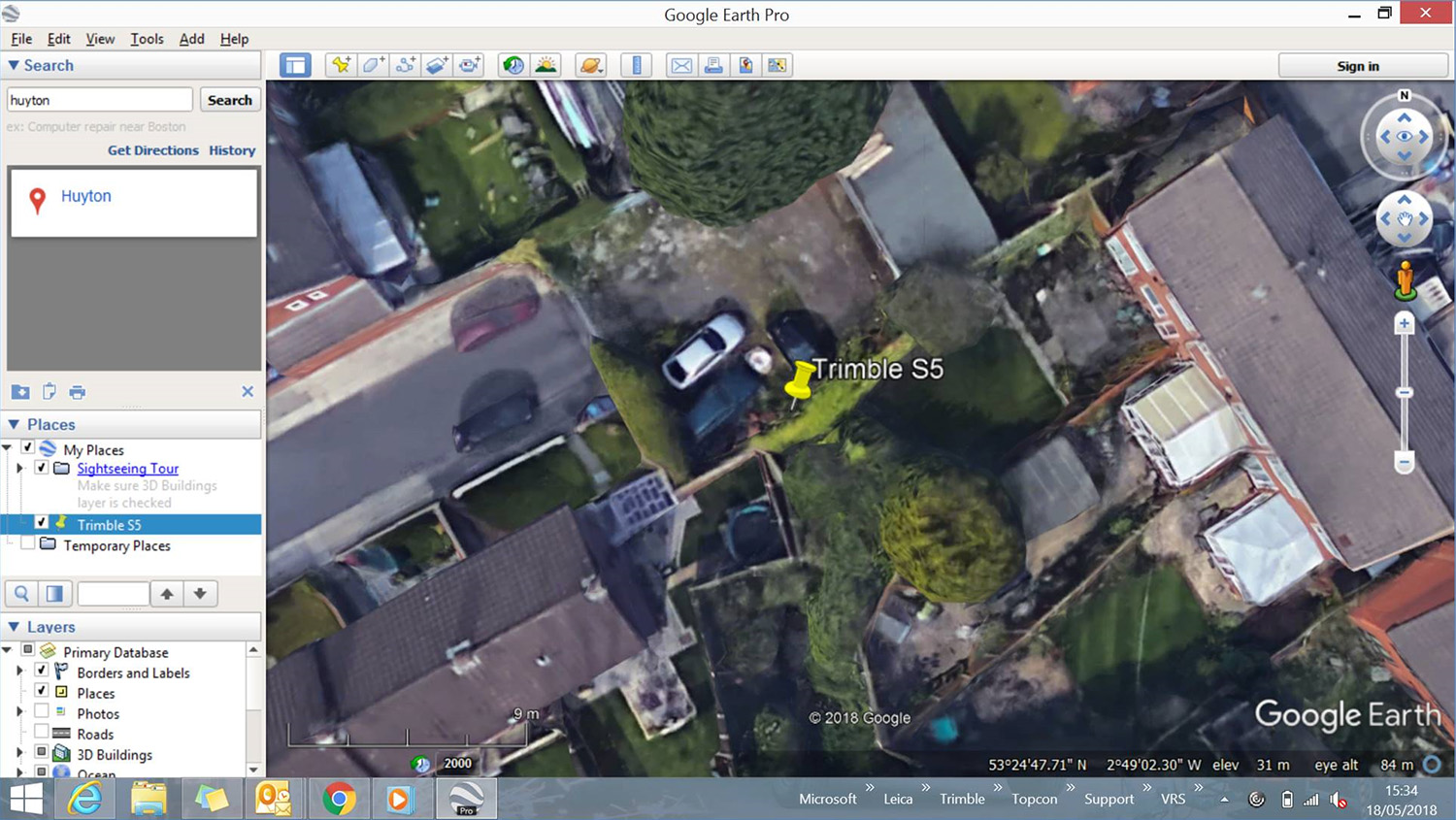
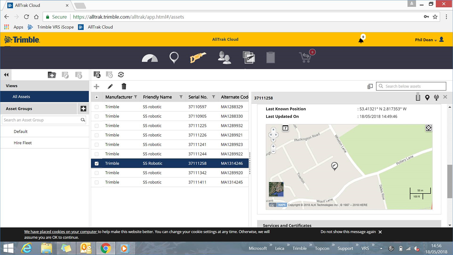
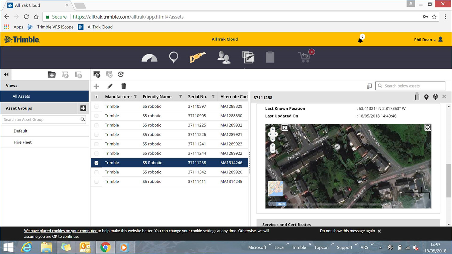
Many thanks to Speedy for informing us of the same day recovery of a Trimble S5 Total Station stolen from one of their clients in Merseyside.
Speedy reports that due to having live data to work from, thanks to Trimble’s built-in L2P technology, Merseyside Police were particularly helpful.

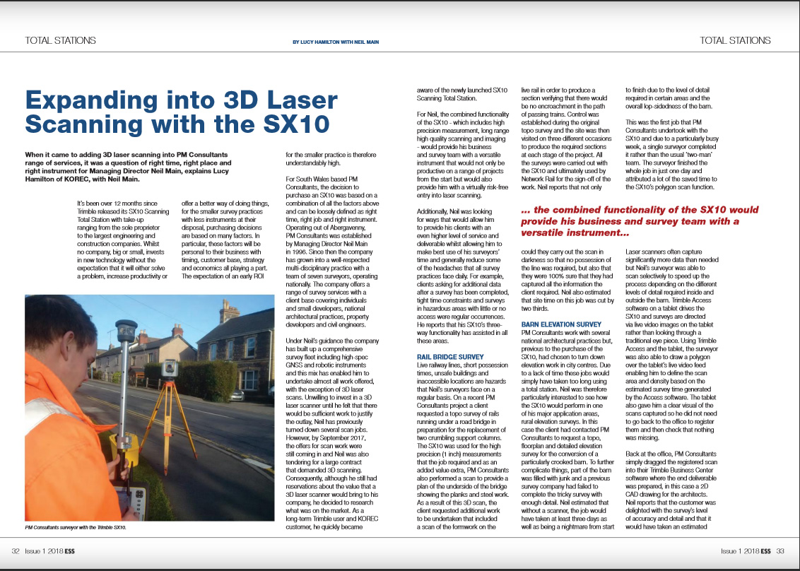
The latest issue of Geomares’ Engineering Showcase features KOREC customer, Neil Main, and his company PM Consultant. Like many smaller survey practices, Neil selects the technology he invests in very carefully. This story looks at why he felt the time was right to purchase a Trimble SX10 Scanning Total Station and make the move into 3D laser scanning.
You can read the full story in Engineering Showcase here or download the KOREC pdf here.
Combining high-quality performance, simple installation and easy operation.
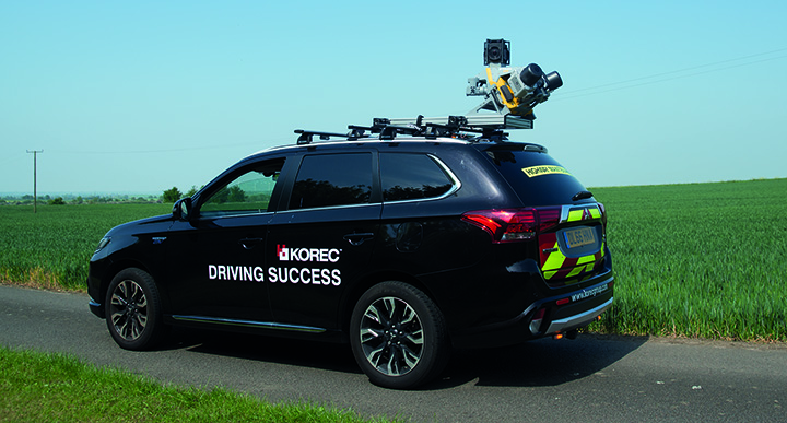
KOREC, Trimble’s leading distributor in the UK and Ireland, has taken delivery of Trimble’s ‘New Generation’ MX9 Mobile Mapping System.
The MX9 will be available to KOREC customers either through purchase or as KOREC’s preferred system for undertaking large-scale scanning and mapping surveys on behalf of its clients through its services company, Professional Services (KPS).
The Trimble MX9 is a complete field-to-finish mobile mapping solution and has been developed to deliver survey-grade data and detail in an easy to use and install design.
Performance
The MX9 combines a vehicle-mounted mobile lidar system, multi-camera imaging and field software for efficient, precise and high-volume data capture, delivering up to 500scans/second. The end result is data of unrivalled accuracy, density and repeatability.
Ease of Use
The system weighs just 37kg and can be easily mounted on a range of vehicles in less than 12 minutes. Operation is through intuitive browser-based field software, accessible via most tablets or any notebook.
As a Service
KOREC Professional Services means every company can offer their clients mobile mapping surveys without a large capital outlay and staff training. Specialising in tailor-made mapping surveys for a wide range of applications including topographic, engineering, and asset management surveys for whole city centres and boroughs or smaller projects, KPS combines expertise with the highest quality of mobile mapping data achievable.
Mark Reid, Professional Services Director said, “Our aim is to expand our customer’s business by offering clients mobile mapping surveys, and all their benefits, without the need for a hefty capital outlay or training costs. KOREC’s acquisition of the MX9 means that we are equipped to offer the very best in precise, high-volume data capture, faster than ever before.”
Alan Browne, KOREC CEO said, “As a company that has already invested heavily in mobile mapping systems, the purchase of a Trimble MX9 was an easy decision to make because simply it places KOREC and K-SERVICES customers, at the cutting edge of mobile mapping technology – the potential is tremendous.”
For a sample dataset or to discuss a Professional Services project, please contact Mark Reid, KOREC Professional Services Director on 07423628529 or by email at mark.reid@korecgroup.com
For sales enquiries, please contact your regional KOREC sales consultant.

ENDS
Many thanks to Geraint Thomas who supplied the information for our latest ‘Business in a Box’ case study – this one looks at how some clear thinking and hardwork has paid off for Geraint who went from zero UAV knowledge to producing top quality aerial imagery in just 8 weeks with his eBee RTK.

The theme for the May/June issue of Geomatics World is “Education is Crucial”, a subject that touches on many aspects of our profession from recruitment to career progression. Editor, Ian Dowman, also points out that this is something that’s covered in the latest KOREC article from our GIS and Mapping Business Area Manager, Richard Gauchwin.
In his editorial he writes, “Richard Gauchwin from KOREC takes up the theme of tailoring data capture to the customer. A key element of educating customers and providing them with what they need is establishing a partnership between educators, industry and users.”
Read Richard’s article entitled ‘Let’s Be Specific’ here.
The theme of our latest case study is very much one of monitoring being an achievable and affordable service that all survey practices can offer their clients.
“Achievable Monitoring” is based on the Greenhatch Group and their use of a Trimble S9 with Trimble’s Access Monitoring Module.
Read the full story here.

Market reports predict a significant increase in the demand for UAV generated data in 2018 and consequently there exists huge potential even for those who may have no previous knowledge of UAV technology but are prepared to invest in the right system, time and training required to offer a quality service that will see clients return. A great example of this approach is Rob Brocklehurst through his company Scottish Drone Surveys. Rob has specialist knowledge of the wind farm construction industry and has expanded his survey offering with the purchase of both a SenseFly albris for – track surveys and access roads and an eBee Plus RTK for
main site surveys. Read the full case study here.

The latest issue of Mensura is now available to download here.
Mensura is KOREC’s quarterly geospatial newsletter packed full of news, new releases, training tips, case studies and competitions. If you’d like to receive a printed copy, please drop us an email at marketing@korecgroup.com and we’ll add you to our Mensura mailing list.