
Here’s our fact file on the Trimble R10 – everything you need to know on why this is a winter offer that shouldn’t be missed!
Since its launch in 2012 the R10 has proved to be one of KOREC’s best selling products. It’s generated more KOREC case studies than any other Trimble instrument and provided us with a CES magazine front cover photograph that became recognisable across the world. Remember this one?

But what do KOREC customers value most about their Trimble R10’s performance? First up, there are honourable mentions for all the R10’s patented technologies including:
- Trimble CenterPoint RTX delivering GNSS corrections via satellite or internet connection with unprecedented speed and accuracy for a PPP solution
• Trimble xFill ensuring less downtime in the field, with continuous RTK coverage during connection outages from an RTK base station or VRS network
• Trimble SurePoint fully compensating for pole tilt for the convenient measurement of points that were otherwise inaccessible with complete quality assurance
But coming in at number 1 in our R10 customers’ most valued feature list is the R10’s cutting edge Trimble HD-GNSS processing engine which simply enables surveyors to measure points more quickly!
Here’s why the R10’s HD-GNSS processing engine makes it the industry’s turn to GNSS solution:
Trimble has a strong history of in-house is development which is why we have HD-GNSS, the ‘quiet’ hero of the R10. In keeping with Trimble’s ability to produce systems aimed specifically at the needs of the land surveyor, the HD-GNSS processing engine of the R10 provides markedly reduced convergence times as well as high position and precision reliability when compared to earlier processing engines, especially in poor GNSS environments. Key benefits Trimble HD-GNSS delivers include:
- Increased initialisation speed
• Improved real-time measurement precision
• Elimination of the possibilities of a “bad fix”
• Increased reliability of precision reporting
• Reduced post processing complexity for the user
The R10 is based around the Trimble Maxwell-6 custom integrated circuit technology for GNSS signal processing RTK calculations are performed in the R10 with a microprocessor that has more magnitude and is more powerful than anything before it and also more energy efficient. The shift to this new methodology makes it possible for Trimble to continue to improve performance as GNSS constellations develop. Fully scaleable through firmware and software updates, HD-GNSS is well positioned to take full advantage of additional GNSS satellites and signals to further improve surveying in increasingly demanding field conditions.All this is possible because, unlike most other providers of survey grade GNSS, development is in-house and fully under Trimble’s control allowing the company to meet a very specific set of requirements, namely those of the surveyor in the field. Download the Trimble HD-GNSS white paper for full details or call your regional KOREC survey consultant for a demo.
KOREC customer R10 case studies
Greenhatch Group switches to Trimble R10’s and VRS Now for reliability
Land and Satellite Surveys – catching up with the first KOREC customer to purchase an R10.
Skanska – the Trimble R10 delivers on M1 J19 improvements.
Costain – M6 and M1 road projects
Academy Geomatics – Coastal monitoring with the R10
……and of course to check out all related R10 features, datasheets and videos, visit here.
KOREC is delighted to announce that under the terms of a new agreement with 3D mobile mapping technology specialists GeoSLAM, it has become an official distributor of the company’s ZEB-REVO handheld laser scanning solutions in Ireland. KOREC already successfully distributes this product throughout the United Kingdom and Northern Ireland.
GeoSLAM specialises in the manufacture and development of “go anywhere” 3D mobile mapping technology, a range which includes its ZEB-REVO handheld, lightweight scanner, ZEB-CAM camera, and the recently launched ZEB-REVO RT (real time) scanner. With no requirement for GPS, GeoSLAM technology allows users to rapidly build a highly accurate 3D models within minutes, whilst on the move. It is adaptable to any environment including complex and enclosed spaces, and especially GPS-deprived spaces – such as indoors or underground.
Once mapped, the synchronised ZEB-CAM imagery and ZEB-REVO point cloud data can be viewed in GeoSLAM Hub software – in both 2D and 3D formats. For larger projects, multiple datasets can also be merged. Results are available in all major industry standard formats and users can select from a variety of export options and configurations to enable greater integration with 3rd party post processing software.
KOREC will be supplying the ZEB-REVO system which includes the handheld scanner, data logger and desktop pointcloud processing software, all backed up by KOREC’s world class support and training.
Mark Poveda, KOREC Group Commercial Director said,
“KOREC is extremely excited to be partnering with GeoSLAM to supply the ZEB REVO system. With the ZEB-REVO scanner you can very rapidly map a huge array of environments to an accuracy level of ±15mm. The ZEB REVO fits perfectly into KOREC’s product portfolio, offering our Irish customers enhanced scanning capabilities on projects ranging from measured building surveys, construction, stockpiles, crime scenes and beyond.”
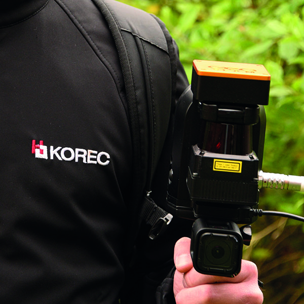
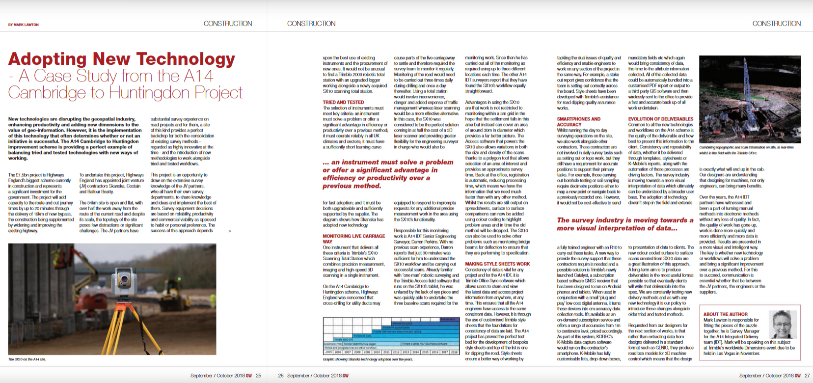
Our thanks to Mark Lawton, Survey Manager for the A14 Integrated Delivery Team (IDT), for his article published in the September/October issue of Geomatics World. Mark is responsible for fitting together all the pieces of the survey puzzle and in this piece explains the team’s approach to the adoption and integration of new technology.
Mark will be speaking on this subject at Trimble’s Dimensions event in Las Vegas in November.
Thank you Jordan Knight, Engineering Manager, Greenhatch Group, for supplying the information for this article on how Greenhatch approaches monitoring projects by selecting the most suitable Trimble instruments depending on a site’s particular challenges.
Read the full story here.
The 2018-2019 Geospatial Engineering (CES) publication is out now and includes a great introduction by Skanska’s Mark Lawson and of course another great story from KOREC.
Our thanks go to Rob Brocklehurst of Rob Brocklehurst Civi Engineering for sharing with us his progressive approach to the adoption of drone technology. Rob has specialist knowledge of the wind farm construction industry and has expanded his survey offering with the purchase of both a SenseFly albris for – track surveys and access roads and an eBee Plus RTK for main site surveys.
The whole article can be read here.
K-Mobile is the key to ensuring that a Canadian rock crushing company maintains maximum efficiency through a structured approach to its machinery inspection process.
Situated in a sparsely populated province of western Canada is a rock crushing company that not only has extreme weather conditions to contend with in both winter and summer but also by virtue of its remote location, a senior management team that is predominantly off site.
The company has a simple work remit in that its only purpose is to crush rock to different criteria with profit directly related to the amount of rock crushed per day. Profitability is therefore reliant on the rock crushing equipment being well maintained and having minimal downtime.
In a move to digitise and streamline the inspection process, the company approached KOREC and the K-Mobile team to focus on two separate issues, a ‘fail-safe’ inspection and defect tracking system for the rock crushing machinery and an easy way for the remote management team to assess the amount of work undertaken – and therefore level of profit – each day.
Inspection reporting/Defect tracking
Harsh weather conditions, particularly in winter, meant that none of the crushing crew wished to be outside longer than they had to be. The rock crushing company therefore required a quick and easy to use but fail-safe system that would provide a ‘chain’ approach to form filling with each element of the reporting process having to be filled in before the operator can move on to the next.
KOREC therefore developed a system incorporating NFC tags (low cost, everlasting tags that can be read by most modern smartphones) and a customised version of K-Mobile running on as smartphone. On each bit of machinery requiring inspection, a tag was fitted which could be detected by the smartphone running K-Mobile. Depending on whether it is a daily, weekly or monthly inspection, the NFC reading brings up the relevant inspection form guiding the crew member through the inspection process, prompting replies from picklists and where appropriate, photographs. This information is then wirelessly transferred back to the site manager, wherever he may be located, and shown ‘live’ on a web-based dashboard where recorded defects are flagged up and can be acted upon immediately. These defects remain ‘open’ on the dashboard until resolved with photographic evidence.
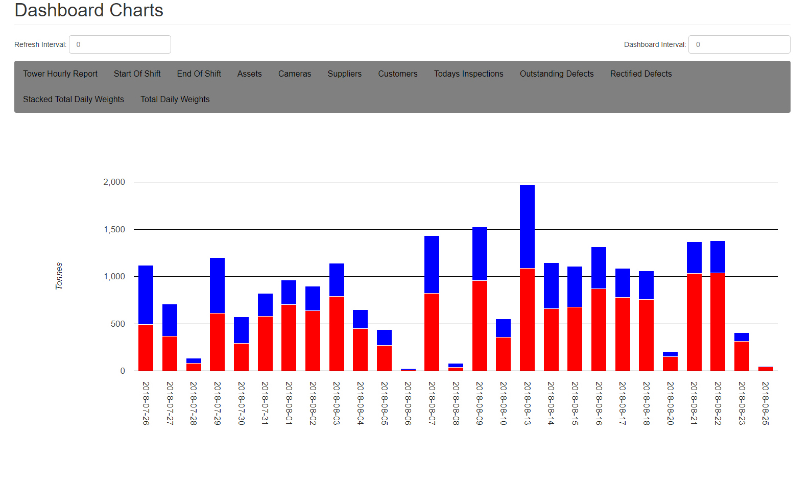
Remote production/volume check
The management team also required a daily report of the amount of each type of rock crushed by weight. The KOREC team therefore integrated the K-Mobile software with the rock weighing scales so that hourly measurements could be taken, along with a photo, and fed into the smartphone showing the increase in weight for both the larger and smaller rock types. From this information the software automatically creates an easy to read bar chart with days of the week and blue and red blocks showing the rising weight of each type of rock. This simple approach make progress extremely easy to monitor at a glance with a line on the graph showing whether a profitable level of crushed rock has been achieved.
This has been a particularly interesting project for KOREC because the principles of the remote management aspect of the K-Mobile software are easily transferrable across many industries.
For further information, please contact the K-Mobile team on 0345 603 1214.
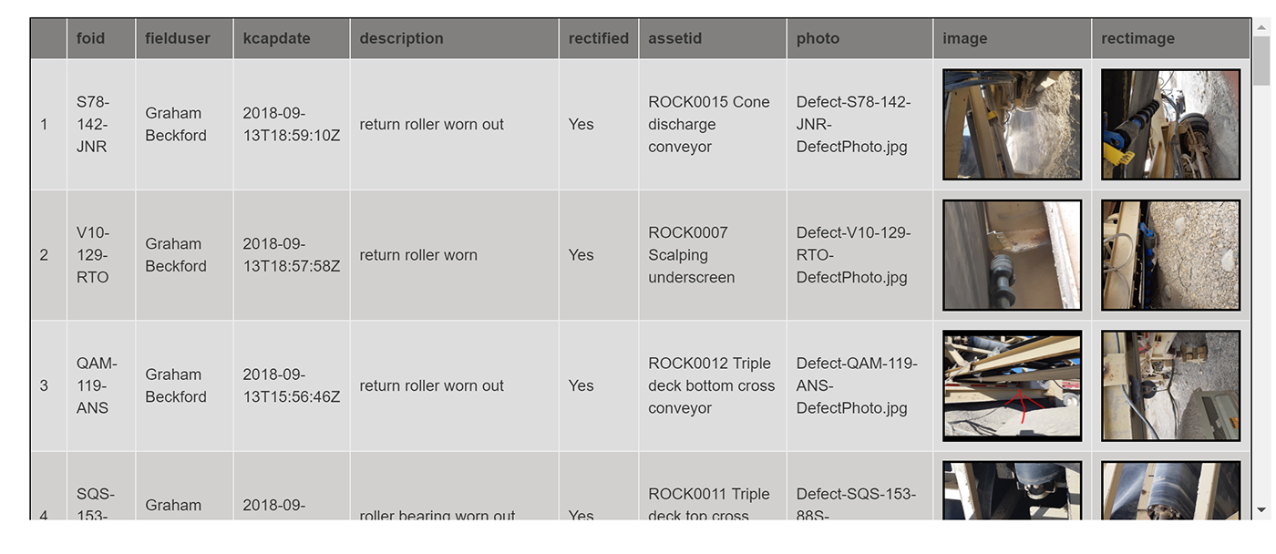
Rectified defect page showing photo of completed work
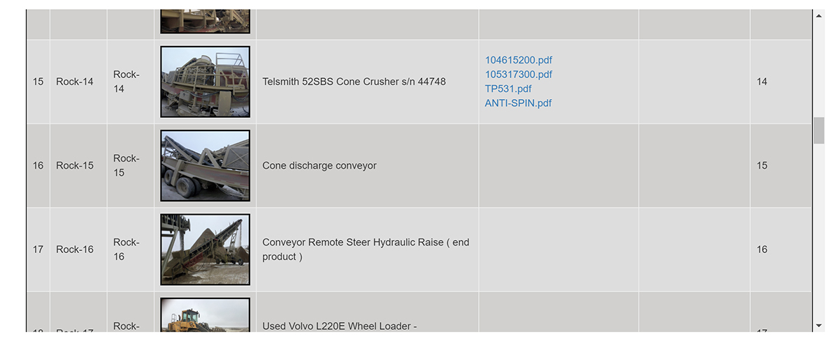
Asset list showing pdf links to all manuals and guides etc
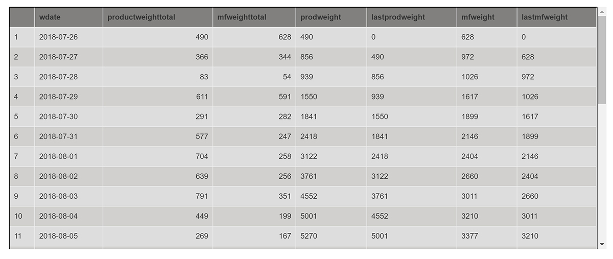
Dashboard showing scale readings per day
Quality, efficiency and safety are the drivers behind senseFly’s latest customer-focused release
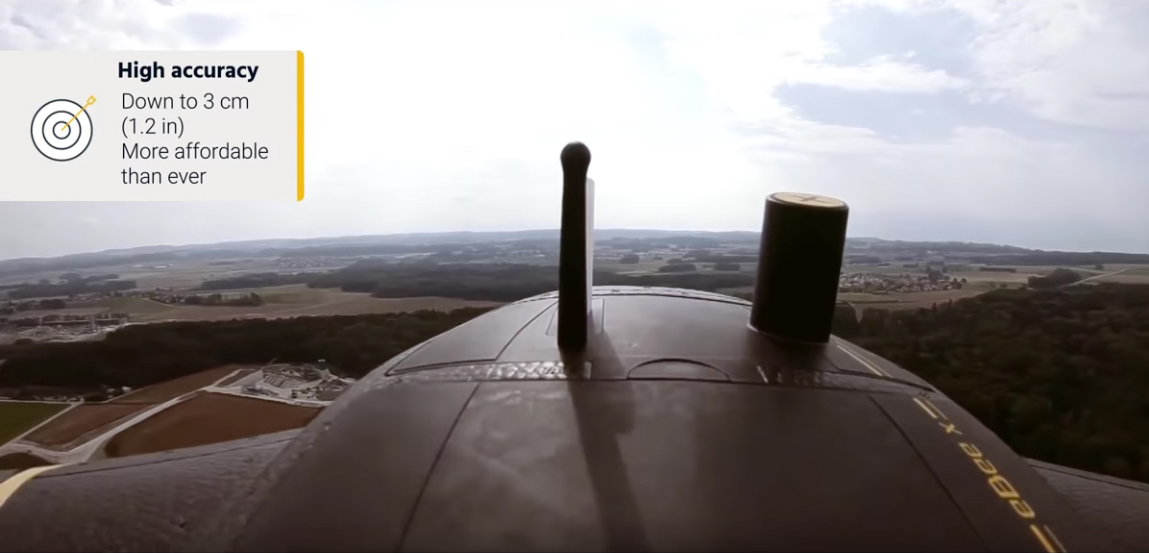
SenseFly has just announced the launch of its latest fixed-wing drone, the eBeeX. Superseding all previous eBee models, the eBee X brings several useful new features along with a significantly reduced cost for the RTK option.
The eBee X has been launched with the promise that “it’s not about the drone,” but instead about overcoming business challenges and indeed it offers a camera to suit every job, the accuracy and coverage capabilities to meet the requirements of even the most demanding projects and is durable enough to work virtually every site.
Here’s what we like:
- Expanded choice of cameras – The eBee X includes a range of revolutionary new camera options to suit every aerial mapping job allowing you to customise your eBee according to your application. Options include:
- senseFly S.O.D.A. 3D, (a unique drone photogrammetry camera with a one-inch sensor, which changes orientation during flight to capture three images (two oblique, one nadir) every time, instead of just one, for a much wider field of view).
- senseFly Aeria X (a compact drone photogrammetry camera with APS-C sensor).
- senseFly Duet T (a dual-camera thermal mapping rig)
The eBee X is also compatible with the Parrot Sequoia+ multispectral camera for agriculture, the senseFly S.O.D.A. drone photogrammetry camera and senseFly Corridor for simple linear mapping.
- Suitable for challenging sites – Built-in space-friendly Steep Landing technology (35° approach)
- Even more rugged – Optimised airframe design and ultra-strong underbody
- Significantly lower cost for RTK option – Worth repeating!
- Endurance Extension option – Unlocks a flight time of up to 90 minutes (versus a maximum endurance of 59 minutes by default) whilst not strictly relevant in the UK, could be useful abroad when flying with less restrictions.
Call 0345 603 1214 to book a KOREC demonstration now
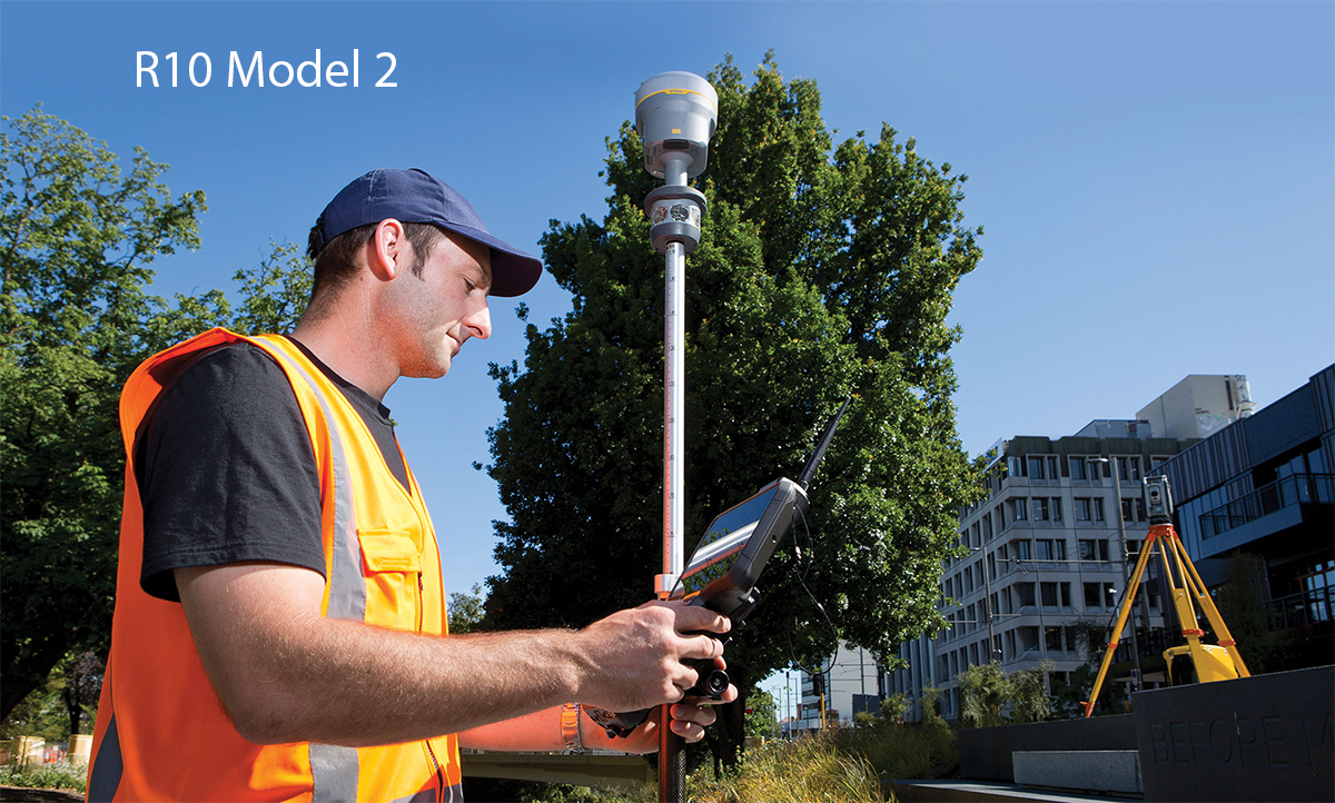
Seriously, we thought it couldn’t get any better, but Trimble has just announced a Model 2 version of its market dominating R10.
Model 2 enhancements include:
- 672 GNSS channels for unrivalled GNSS constellation tracking, including GPS, GLONASS, BeiDou, Galileo, QZSS, IRNSS as well as the full range of SBAS. The Trimble R10 tracks and processes all of today’s available GNSS signals and is designed to support planned GNSS signals and systems that may be launched in the future.
- Improved reliability against sources of interference and spoofed signals.
- 33% more operating time in the field (on average) thanks to improved power management to increase battery life.
- Store more than 10 years of raw observations thanks to an increased internal memory (6 GB).
- Even better equipped for Bring Your Own Device (BYOD) environments with support for Android and iOS platforms.
And of course the Model 2 includes all the Trimble R10’s core technologies:
- Trimble HD-GNSS processing engine that enables points to be quickly measured with confidence
- Trimble SurePoint™ technology for precise positioning capture and full tilt compensation
- Trimble xFill® technology for centimeter-level positioning during outages
- Support for Trimble CenterPoint® RTX corrections for RTK level precision worldwide
Call 0345 603 1214 to book a KOREC demonstration now
The K-Mobile team is nothing if not accommodating and most of all they enjoy problem solving, no matter how large, or in this case, how small! Here are three of the latest that they’ve been tackling.
Help – no one delivering goods or visiting us on our motorway site can find us!
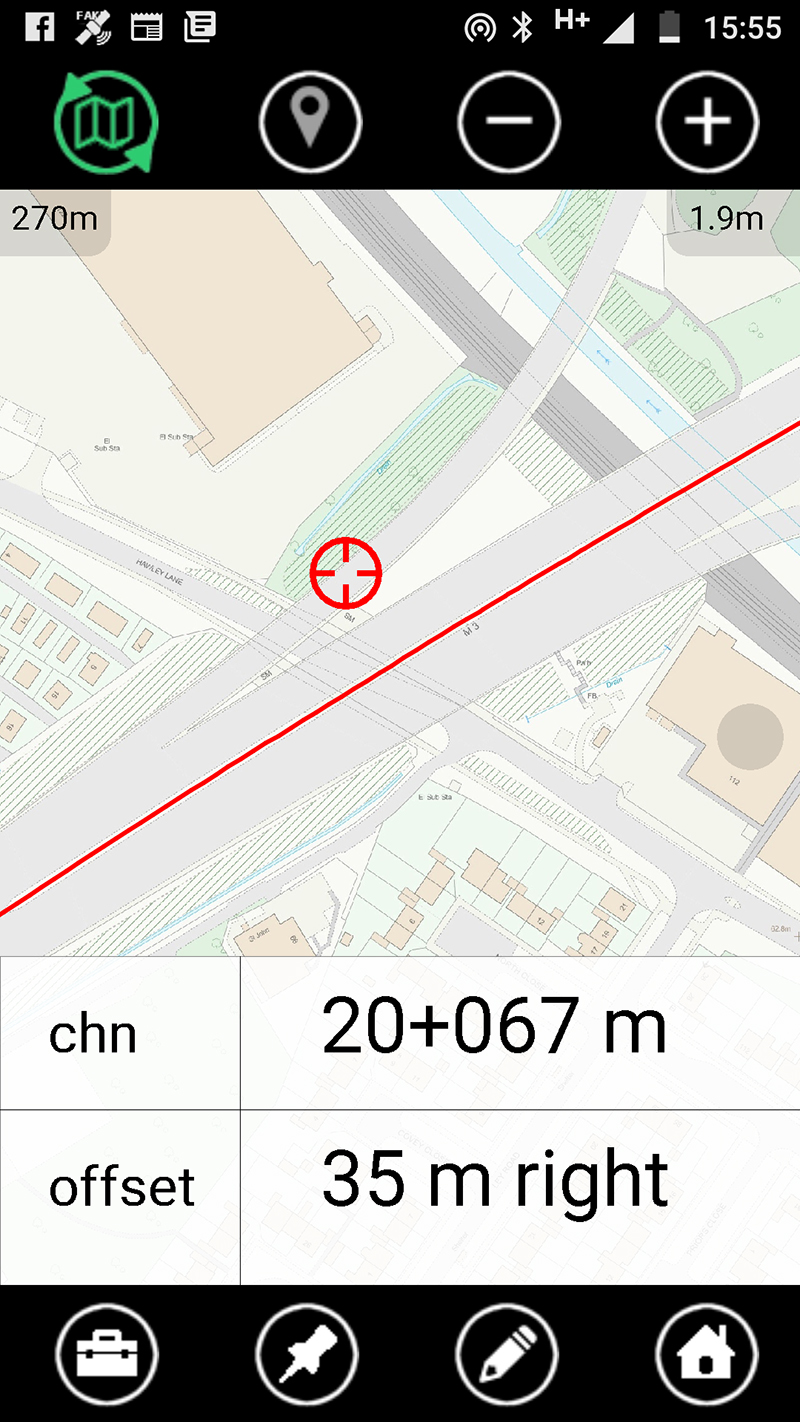
Large road construction projects are all referenced by chainage so we’ve developed a really useful little function that’s now included in all versions of K-Mobile. Designed to provide users with a free dynamic chainage display on any linear job, it’s ideal for deliveries and visitors who can be provided with access via a link.
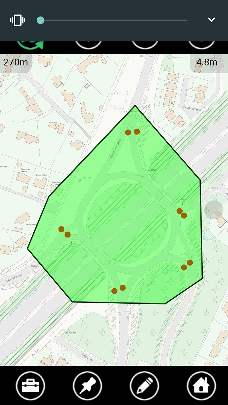
We’re collecting information on traffic light conditions but have to open up each individual record to tick a ‘fully functional’ box. When we have 20 sets of working lights on an intersection this can take 20 minutes. How can we speed up this process?
Welcome to ‘lassoo assets’! It does exactly what the name says and can be used on any asset type allowing for a time saving ‘batch’ approach to changing a field. In this case we developed ‘lassoo assets’ as a useful add-on to K-Mobile, making the process 20x faster. This is just the sort of small development the K-Mobile team can undertake in less than a day!
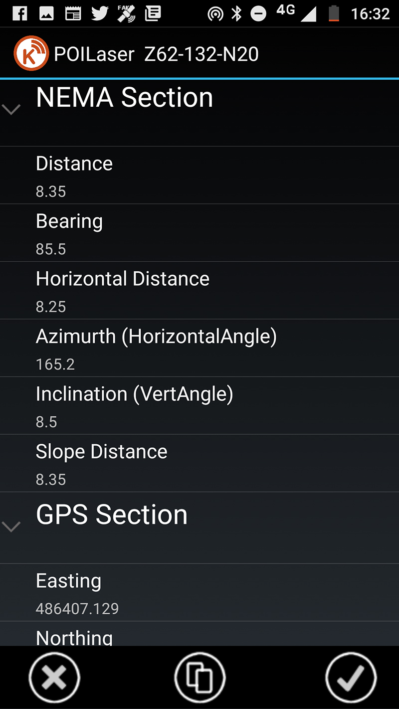
How can I QA check the offset measurements from my laser rangefinder
With the rise of Trimble Catalyst (software based GNSS) running on tablets, we’re seeing increased usage of the TruPulse laser rangefinder for offset measurements as an alternative to the Trimble GeoExporer with its built -in laser. The K-Mobile team has responded accordingly by enhancing the form that pops up automatically when a laser measurement is taken. You can now store any laser measurement and the coordinates of where you are standing as attributes. Two positions – ideal for QA purposes!
Although developed for handheld lasers, this feature works with any NEMA style BlueTooth device such as sonar devices and radiation detectors.
What would improve your productivity? Please contact the K-Mobile team on 0345 603 1214
KOREC’s customer service and technical support accounts for 80% of Coastway’s decision
Coastway Surveys is a thriving survey business with offices in Ireland and the UK. Offering a wide range of services including land, engineering and aerial surveys, scan to BIM and mobile mapping, it is a company that has prepared for further expansion with a new management structure designed to meet the needs of a growing business. As a part of this re-structure, Paul Moir has taken up the new role of Operations Director bringing with him extensive surveying, engineering, data analysis and consultancy skills from over 20 years of worldwide industry experience.
One of Paul’s first strategic decisions was to select a preferred surveying instrument supplier that was equipped to grow with Coastway Surveys and work with it as a partner during its expansion into new business areas. Although Coastway had had satisfactory relationships with a number of suppliers previously, Paul felt that whilst price, reliability and functionality of equipment would be key criteria, the overriding consideration would be the level of service and support that a supplier could offer. Familiar with Trimble technology, he therefore contacted KOREC Ireland and was impressed immediately by the fast response of the team, by KOREC’s personal approach and by the set-up of the company’s Technical Support department.
Paul explains, “Service and support are key to the day to day running of our surveying and engineering services. Even the best instruments and software can have break downs or blips and KOREC has proved itself to be extremely proficient in dealing with these issues, whether it’s with the free loan of a replacement instrument or solving something over a quick phone call. For me service and support was 80% of the Coastway decision to go with KOREC as our preferred supplier and the service we have received has been exceptional. The team is always contactable with dedicated support staff so that I never feel I am taking someone away from another area of their job. Issues are addressed immediately and both the technical and sales staff are entirely flexible in their approach – I’ve even had the Regional Sales Director meet me on site over a weekend. Along with some excellent free training, this is the sort of relationship that we believe will help Coastway’s dynamic approach towards expansion into new business areas.”
Coastway Surveys has invested in a wide range of KOREC supplied instrumentation including Trimble R10 GNSS, S6 Total Station, SX10 Scanning Total Station and TX8 Laser Scanner technology. The company has also purchased senseFly eBee Plus fixed wing survey drones.
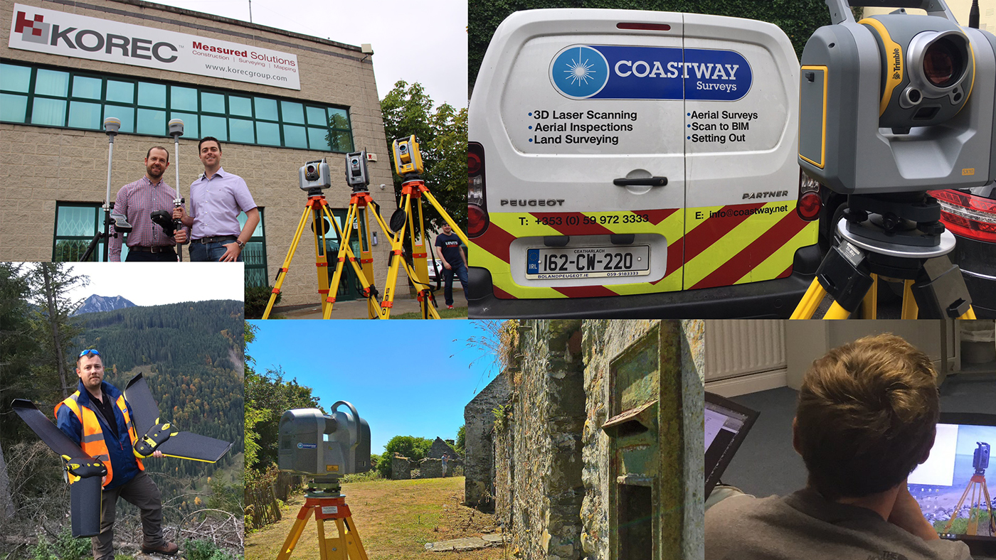
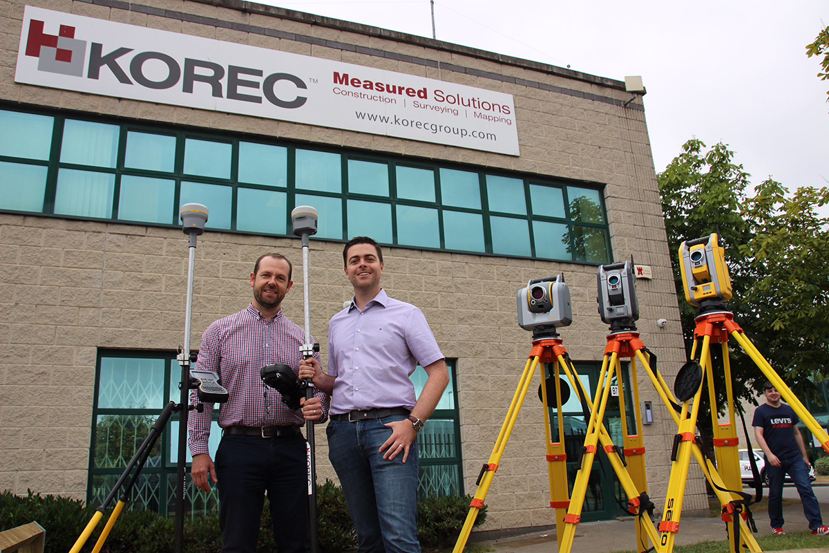
Coastway’s Paul Moir (top left) with Shane Murtagh of KOREC