Construction intelligence has valued UK contracts in 2017 at £71bn. A great number of these will require some form of monitoring which is why adding deformation monitoring to your survey portfolio can be highly profitable.
And it’s easier than you think. More often than not, you already have the equipment to do it with basic systems requiring nothing more than a Trimble Total Station with FineLock technology and the stake-out function in Trimble Access software running on a controller.
Alternatively, you may already have a laser scanner for creating surface models and of course surface to surface comparisons, ideal for detecting a bulging retaining wall, without the need to put prisms on structures.
The next step would be investing in Trimble’s modestly priced 4D monitoring app for setting up a measuring regime. Full information on all these options, and more advanced ones, is available from our webinar.
It’s been a busy first half of the year for KOREC and so much has happened that we’ve published an extra issue of Mensura this year. Welcome to the July newsletter!
Key topics include:
Case study – ‘Business in a box’
KOREC support – why we’ve upped the game
Introducing our new Trimble MX9 Mobile Mapping system (right)
Product news – the TSC7
…and much much more.
If you’d like to regularly receive a hard copy of Mensura in the post, then please sign up here.
KOREC is delighted to announce that following a successful tender, it has supplied Ordnance Survey with fifty-five Trimble new generation Trimble Alloy GNSS Reference Receivers in support of OS Net. OS Net is Great Britain’s national global navigation satellite system (GNSS) infrastructure, operated by Ordnance Survey.
The Alloy units will be supported by KOREC for the duration of the five year contract.
The Trimble Alloy Reference Receiver is both future proof and the most technically advanced GNSS receiver available on the market today being compliant with GPS, GLONASS, Galileo, BeiDou, EGNOS, QZSS, IRNSS, SBAS and L-Band whilst the inclusion of dual Trimble Maxwell 7 chipsets combined with a powerful processor provides strong tracking and processing power. Additionally, with 672 channels, Alloy has the capacity to accommodate additional signals as they may become available, eliminating the need to replace hardware to keep pace with technology.
Mark Poveda, Commercial Director, KOREC, said “The next generation Trimble Alloy Reference Receiver will assist the Ordnance Survey in its plans to modernise its network. Users of OS Net can now receive signals from the widest range of constellations available enabling them to be more productive in the field and work effectively in challenging GNSS conditions. KOREC prides itself on a reputation for delivering cutting edge Trimble technology backed up by a high level of service and support and we believe that this combination has helped us to win the prestigious order with Ordnance Survey.”

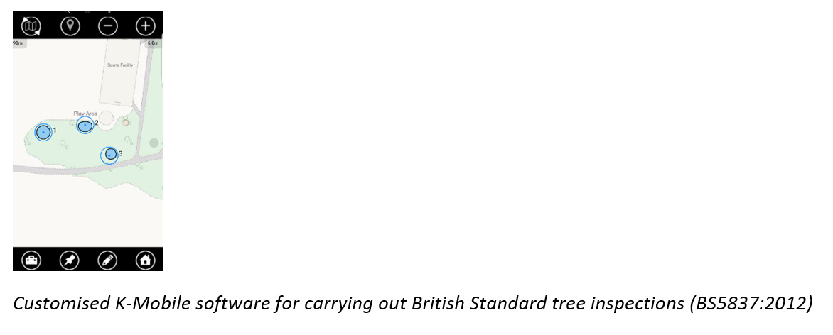
The latest functionality that we’ve added to our K-Mobile field data capture software has been developed specifically to save time and speed up efficiency in the field, especially for those working in high density asset areas. Field workers can now select a wide range of feature points from the front screen saving at least a couple of clicks for each asset recorded.
We’ve also introduced a new form ‘Clipboard’ feature. This is ideal for anyone who has a number of forms to fill in, but not all in one go. Users can now revisit the same form at intervals throughout the day, without the risk of duplicating the form, and add information as and when it’s collected. Coloured white, amber and green icons for each form provide a quick glance progress report as to how much information has been collected for each of these forms. Useful!
How examining your database can shape your company’s future. KOREC’s Business Area Manager – Mapping & GIS, Richard Gauchwin, shares some thoughts on how our GIS and mapping customer base has changed over the years and what this means for the future.
With GDPR well and truly upon us, here at KOREC we’ve be closely examining our customer database to ensure that only those of you who wish to hear from us do.
Taking the time to analyse our customer data has reminded us just how many industries we’ve been working with and how varied our customer applications are. But what can we learn from our changing database and how will it shape our future plans?
Emphasis on efficiency – more industries are going digital
A decade ago, KOREC’s strongest message for potential mapping customers was ‘…if you want to become more efficient in both the field and the office, ditch the pen and paper and go digital’. Our case studies focused on ‘core user’ examples involving street column surveys, cemetery mapping and street furniture inventories with the collected data usually managed on a corporate GIS. Today, our database shows that adoption of digital data capture, digital inspections and digital data verification is now widespread across a broad base of users, and it’s easy to understand why. Whilst the need for greater efficiency never diminishes, fortunately the cost of the relevant hardware and the length of the software learning curve has!
KOREC Opinion – With these barriers removed, going digital is a ‘no brainer’ – the benefits far outweigh the investment! We expect the market to grow and broaden.
Our customers seek solutions rather than products
There is no doubt that today’s KOREC/K-Mobile customer has a far more sophisticated approach to data capture than ever before. It goes way beyond the initial need for a product or system that simply enables the recording of just the positional and attribute information that we were still seeing even five years ago. KOREC customers now want this geospatial element to be part of an overall workflow where the end product is intelligent data that can be queried and used for proactive rather than reactive purposes. Our customers don’t want to just know where a certain gully is, they want to know when it was last cleaned? How often does it flood? Does its maintenance programme need changing from every six months to every two months. In short, can it be part of a proactive maintenance problem that will improve efficiency and cut costs?
KOREC Opinion – More and more of our customers want a fully integrated system that allows them to capture, update and query information in a seamless process. We’ll be continuing to develop K- Portal, our hosted, cloud based solution for the live monitoring of a project’s progress and the assignment of work orders based on intelligent information. In a recent industry survey*, 84% of respondees think users are now demanding complete workflow solutions rather than standalone products and we’re completely in agreement.
Customisation is king!
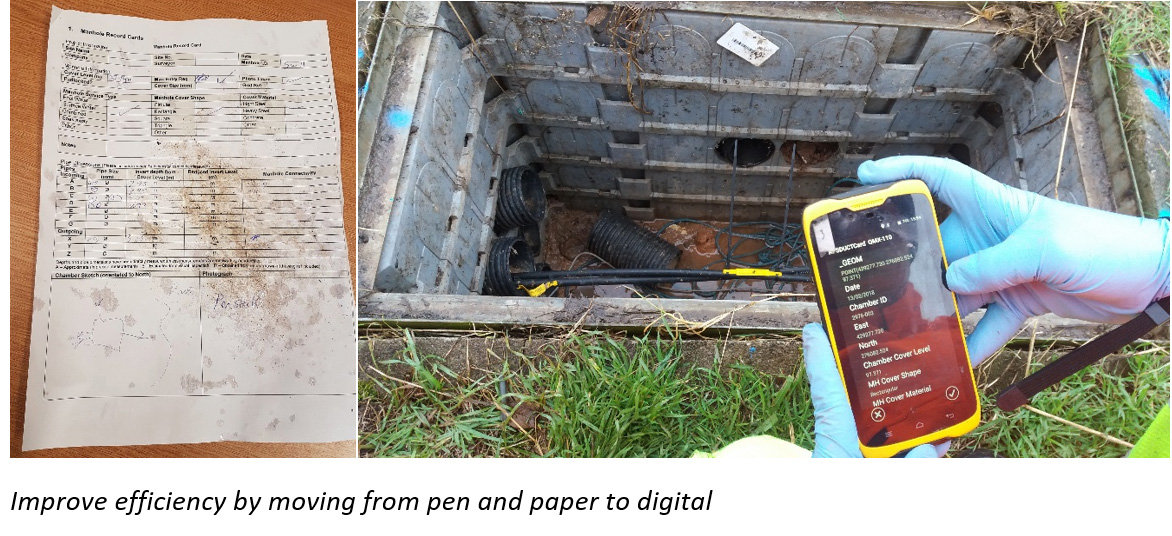
We’ve recently devoted a whole Let’s Be Specific article to this very subject and it’s just been published in Geomatics World. During the past twelve months, KOREC’s in-house software development team has been approached many times over by customers with very specific requests. For example, “We want to move from pen and paper to digital data collection and retain our existing workflow because it works well but off-the-peg data capture software won’t allow us to do this.” Or “We want software that automatically calculates a value we need out in the field for immediate decision making rather than our current system that requires us to process information back in the office.”
KOREC Opinion – Our in-house software development team has customised applications on behalf of many industries. But here’s another thought, if customisation is generally accepted as a crucial element in the successful take-up of a system, why not create data capture systems that are not just application/industry specific but customer specific?….and that’s exactly what we’re doing by handling requests from the smallest tweak to full systems. We expect widespread take-up of customer specific solutions.
Greater acceptance of cloud computing and its benefits
Not so long ago, ‘The Cloud’ was viewed as a slightly suspicious concept that may or may not be secure. Five years on and it’s been an industry game changer. Importantly, access to the cloud is through any web browser, minimising impact on IT infrastructure and resources. This easy access, combined with the increased bandwidth for storage, processing and sharing of data, has changed the way we present data, share it and act upon it.
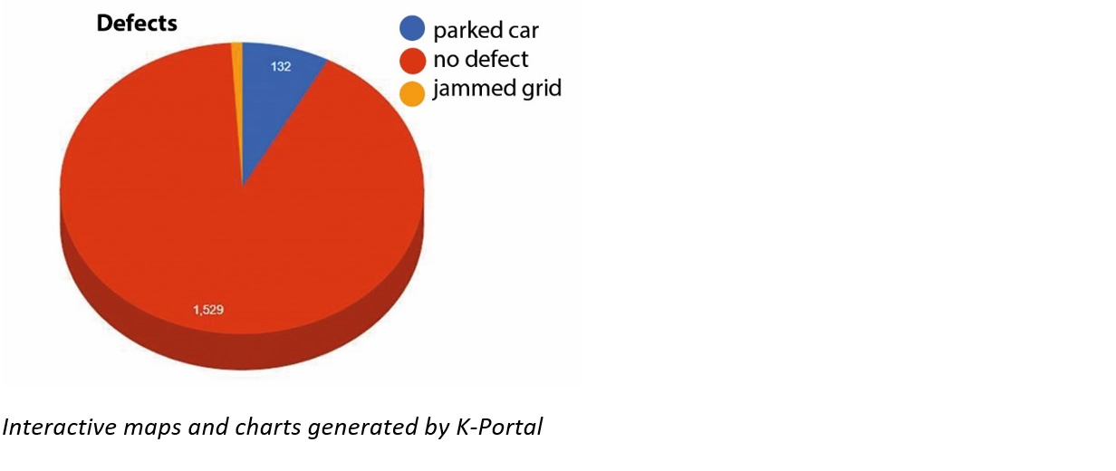
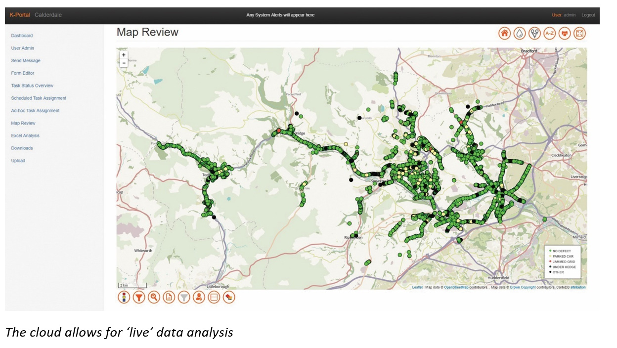
In particular, users of our Mobile Mapping service for large projects can use our K-Portal to monitor work on a minute by minute basis through a ‘breadcrumb’ trail and this useful information can be used in interactive charts, for example, just click on a segment to view the location of all recorded defects. This means information can be acted on immediately.
KOREC Opinion – More and more KOREC customers are asking for customised solutions that include our K-Portal hosted, cloud based solution for the live monitoring of projects, live analysis and the issuing of work orders. In fact, we have one customer that, via the cloud, remotely manages its operations on the other side of the world! And of course, as data becomes viewed by more shareholders, the quality of the end product or deliverable, whether it be a report or a plan, will become even more important.
‘Geospatial’ is everywhere
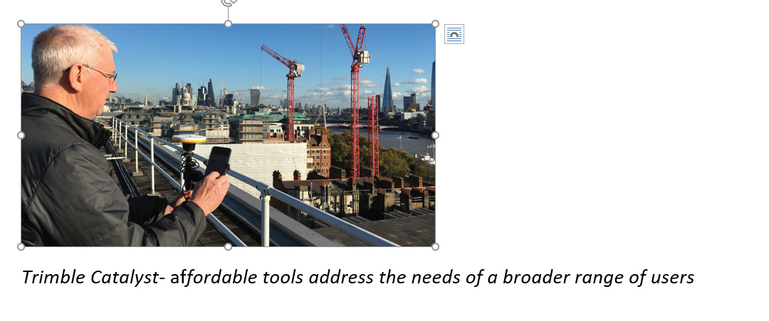
Thanks to the rise of the Smartphone, field software such as K-Mobile (running on both Windows and Android), and of course Trimble Catalyst, the industry’s first software, low cost, subscription based GPS, affordable cm positioning is now available to everyone. The arrival of Trimble Catalyst, a simple ‘plug and play’ system means that accurate data collection is no longer reliant on a full understanding of coordinate systems, geodetic datums and correction sources.
KOREC Opinion – Unlimited growth outside of our traditional customer base. The affordable tools are all in place to address the needs of a broader range of users, particularly those for whom accurate, positional data is important but still secondary to their line of work.
A new age of entrepreneurs
We are entering the Fourth Industrial Revolution, one that will be driven by A1, Big Data, IoT, Robotics and Cloud Computing. The rate of innovation is likely to be fast because our world has greater connectivity than ever before. Consequently, we will see a new generation of thinkers, those who have grown up with Smartphones and the cloud, who will be better equipped to push the boundaries of the geospatial industry from both inside and outside and use positional information in ways that, as yet, we can’t even imagine!
KOREC Opinion – We are already seeing signs of this through the Ordnance Survey’s Geovation initiative. Based in London ‘The Hub’ is a data lab for creative people who want to experiment with property and location information and technology. It is also the recipient of a number of free Trimble Catalyst Licenses to further assist innovative use of high accuracy positioning. Exciting project at the hub are combining Catalyst, robotics and AI. Watch this space!
Alex Wrottesley, Head of Geovation, commented: “Location is at the heart of all new technology propositions. In a world where smartphone use is ubiquitous every interaction can be connected to location-data and intent. At Geovation we work with hundreds of entrepreneurs and startups looking at opportunities in almost every sector – property, infrastructure, connectivity, transportation and wellness to name a few. We can’t wait to see that the next generation of businesses can do with the technologies that are now available to them”.

In conclusion, we can’t begin to imagine what our customer database will look like 10 years from now but we are preparing for a customer that is well versed in the benefits of Big Data, AI, Robotics, Cloud technology, Customised Workflows and subscription based services.
*We’re not the only ones to share our views on the market. Over 50 geospatial industry leaders have been sharing their thoughts and opinions in the Geospatial World Leaders’ Outlook report. It’s well worth a read.

Thanks to GeoConnexion UK for covering our story on how one enterprising individual got an aerial survey business off the ground and delivering high quality imagery in just eight weeks.
KOREC customer, Geraint Thomas, shares with us how he successfully immersed himself in the world of aerial surveys in order to help out a client of his photography business, Horizon Nuclear Power, that required fast delivery on high quality site imagery on Anglesey. Geraint’s UAV (a senseFly eBee Plus RTK), his pilot training through The Drone Pilot Academy and his product training were all arranged through KOREC as a package as was onsite support for his early flights.
Read the full story here.
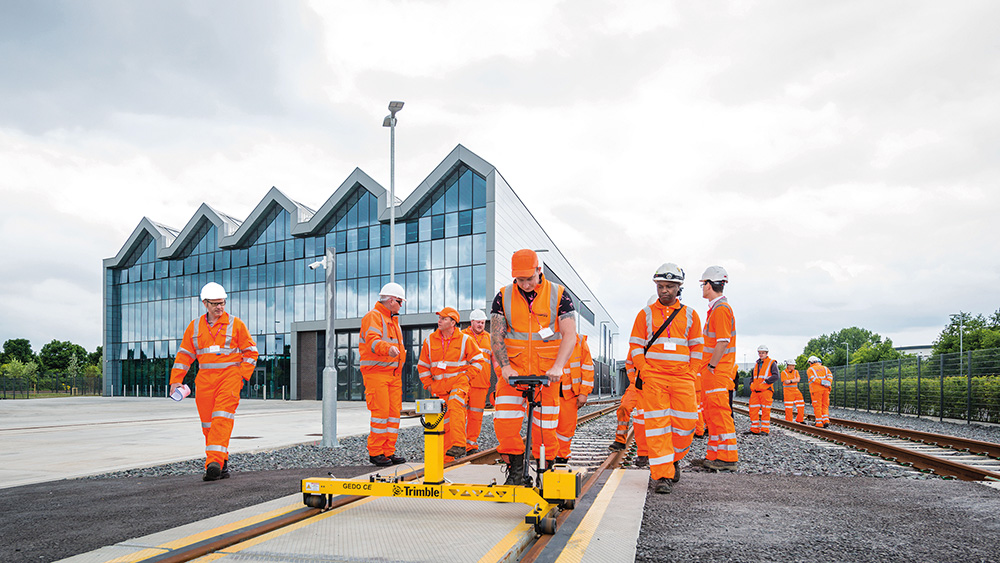
The Doncaster campus of The National College of High Speed Rail (NCHSR) was the location for KOREC’s UK launch of Trimble’s GEDO IMS, a lightweight, flexible and fast system that combines an Inertial Measurement Unit (IMU) with scanning and geodetic sensors for surveying railway lines and documenting assets along the track.
The day was attended by key players from the UK rail industry who all enjoyed presentations and live demonstrations from KOREC and Trimble rail specialists Matthew Lock and Tom Williamson (KOREC) and Matthew Moss (Trimble).
Many of the attendees remained for a tour of the College at the end of the day. NCHSR (Doncaster) was opened in October 2017 by education secretary Justine Greening and was the recipient of a significant gift from Trimble to expand its training and research in railway design, construction and maintenance.
Matthew Lock, KOREC Business Area Manager – Rail and Monitoring, said “The new Trimble GEDO IMU is a fantastic addition to the well-established GEDO family. It offers fast initialisation, high-speed precise measuring and robust construction in a lightweight package. The increased productivity and ease of use, coupled with the fact that it is a single-TMD solution, means our customers take less time on site and do so more safely. We have been really delighted with the response from our customers and look forward to continuing to promote Trimble’s highly productive rail portfolio.”
Clair Mowbray, NCHSR CEO, said, “We are delighted to have been the host venue for KOREC’s UK launch of Trimble’s GEDO IMS and to have welcomed key players from the UK rail industry. Our unique facilities set us apart and we are thrilled we were able to help KOREC demonstrate their new system on the track at the Doncaster campus.”
For further information on Trimble Rail Solutions supplies by KOREC, please contact matthew.lock@korecgroup.com
Can Trimble’s SX10 be a useful alternative to a UAV survey? In the CES June issue, Tri-Tech’s Ted Harland explains how his Trimble SX10 Scanning Total Station saved the day when the ‘Beast from the East’ grounded his UAV.
Read the full story here
Or download the KOREC case study here
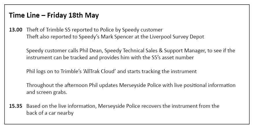
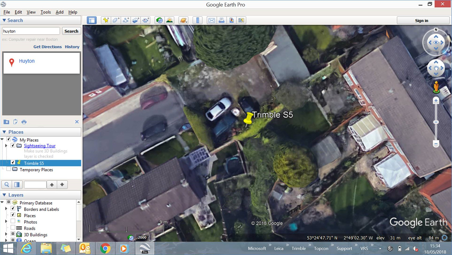
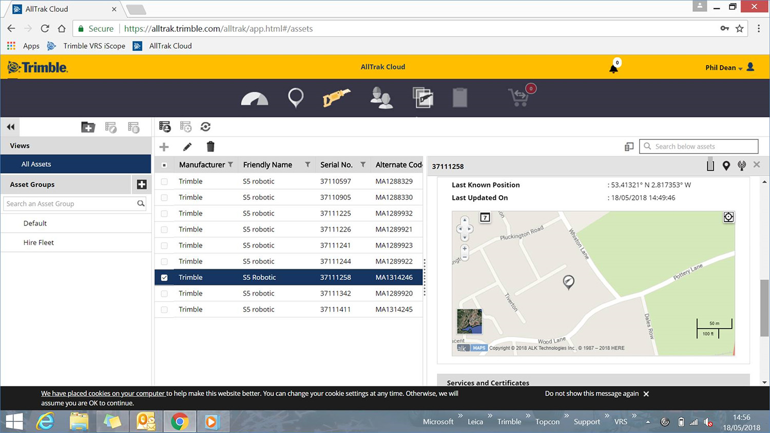
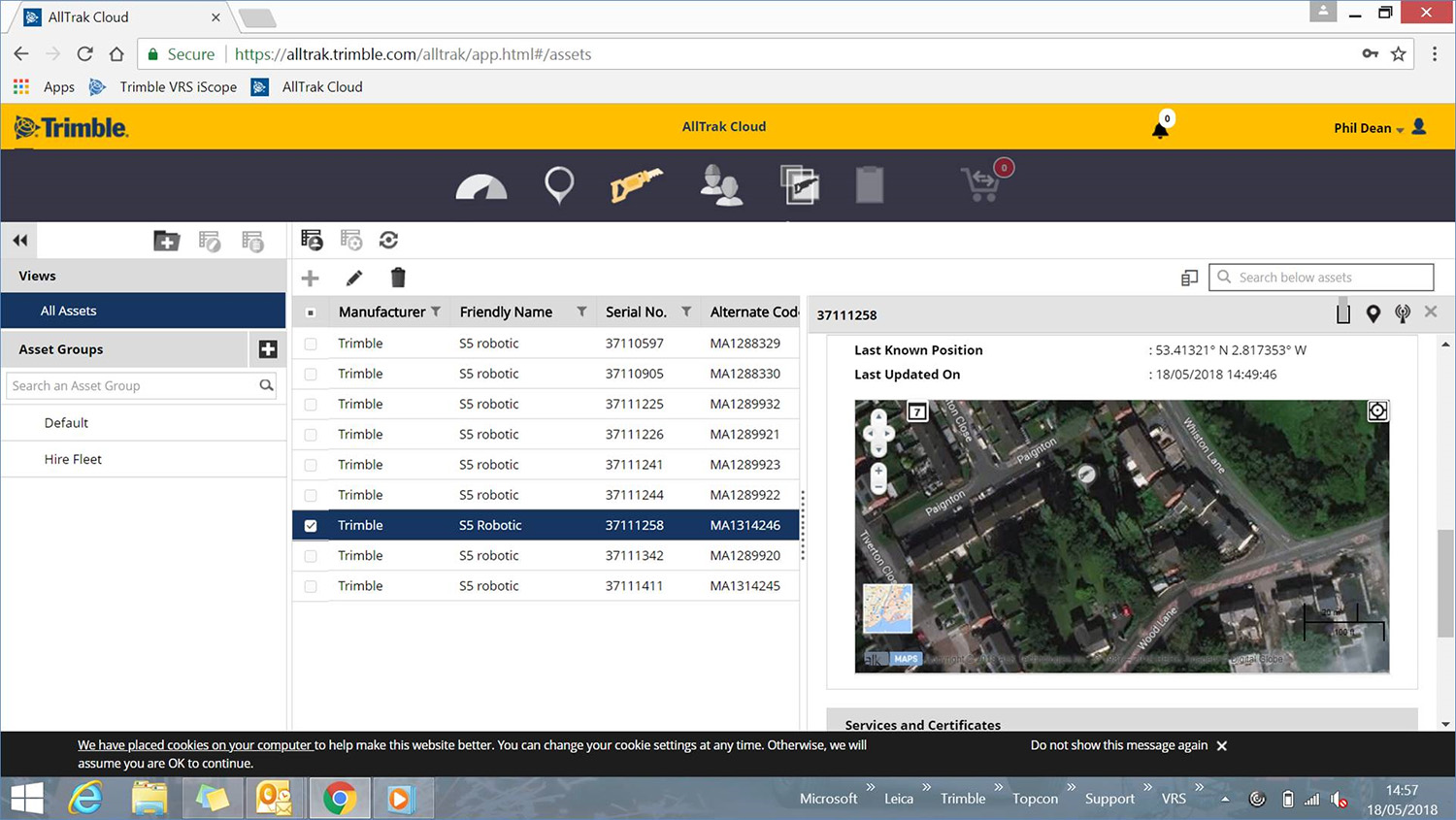
Many thanks to Speedy for informing us of the same day recovery of a Trimble S5 Total Station stolen from one of their clients in Merseyside.
Speedy reports that due to having live data to work from, thanks to Trimble’s built-in L2P technology, Merseyside Police were particularly helpful.
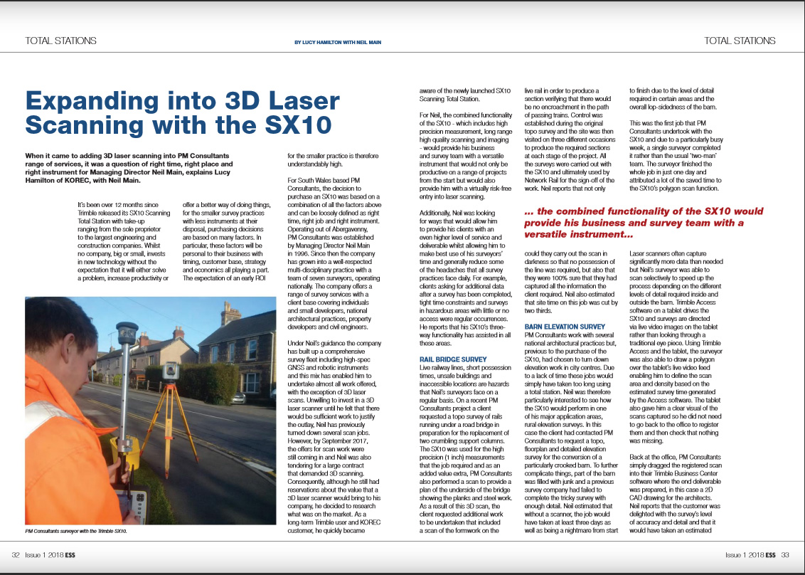
The latest issue of Geomares’ Engineering Showcase features KOREC customer, Neil Main, and his company PM Consultant. Like many smaller survey practices, Neil selects the technology he invests in very carefully. This story looks at why he felt the time was right to purchase a Trimble SX10 Scanning Total Station and make the move into 3D laser scanning.
You can read the full story in Engineering Showcase here or download the KOREC pdf here.