The reliability of the Trimble X9 Core for 3D laser scanning has made it a go-to tool for the Royal Agricultural University, both in preparing the next generation of land and property managers and in supporting important research projects that are reshaping how we understand and manage heritage sites.
View a formatted PDF of the story here
The Royal Agricultural University (RAU) has been at the forefront of agricultural education and a key contributor to the land-based sector for 180 years. Renowned for producing high-calibre graduates who go on to manage 70% of the surface area of the British Isles through cultural and heritage organisations or private ownership, the RAU has invested heavily in preparing its students for life beyond study. This includes the creation of a £6 million geomatics lab and ensuring that students gain a strong working knowledge of relevant technologies such as 3D laser scanning – something that a number of students have incorporated into their final dissertations.
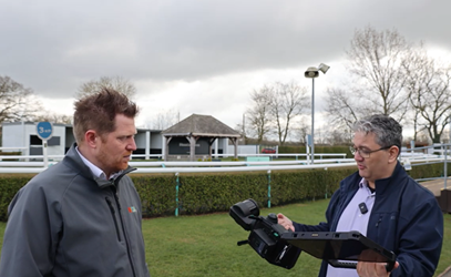
A number of these projects are led by Professor Mark Horton, Director of Research at the RAU. An archaeologist, tv presenter and writer with global interests, Mark’s aims lie in preserving the environment whilst uncovering new information through investigation. He is therefore an avid user of the KOREC supplied Trimble X9 Core 3D Laser Scanner* (part of RAU’s wider Trimble portfolio), finding its reliability and ease of use an ideal combination for both student training and the university’s research projects.
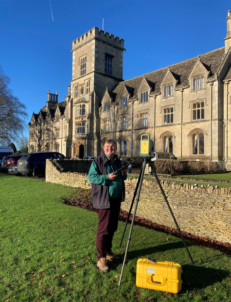
Professor Mark Horton
These research projects cover a range of areas from documenting the excavation of roman ruins to biomass measurement for carbon offsetting, and most recently, a nationwide investigation of cave dwellings that is changing the way we understand and manage these sites:
Documenting and dating a cave dwelling
Across England, more than 150 cave dwellings are cut into the soft sandstone that dominates certain regions, particularly the Midlands and Derbyshire. The aim of the RAU research project, led by Senior Research Fellow Edmund Simons, was to create a permanent record of these “monuments of the landscape” and to gain a clearer understanding of the alterations and expansions they have undergone over the centuries.
The nature of the work posed several survey challenges that ruled out traditional tape measurements (too time-consuming with the highly irregular shapes made drawings impractical) and also discounted SLAM technology (accuracy and reliability could not be guaranteed in such demanding environments).
With 3D laser scanning selected as the method of data capture, it was crucial that the Trimble X9 Core could perform in the difficult conditions encountered across the cave sites and deliver in key areas:
- Ability to capture a very accurate, high-density point cloud to help the team understand how the caves developed over time
- Reliable scanning of a wide range of cave surfaces and different construction materials to reveal the differences between them
- Ability to handle the complexity of cave design
- Robust build for use in extreme and difficult environments
- Self-levelling ensuring reliability even for non-technical staff
- Auto-calibration before each job, all backed up by a report for easy deployment around the world and avoiding the downtime that can occur with other scanners when you have to send them away for calibration, often abroad, for weeks if not months.
- Provision of on-site registration, essential for building up real-time information on the extensive network of passageways, some extending up to 100 metres
- Straightforward operation that could be relied upon in challenging field conditions
- Sufficiently lightweight and portable – sites are often remote and land access hard to obtain
Following extensive use of the Trimble X9 Core in these conditions, Mark reports that it handled the challenging cave sites without issue and has helped them to make some important discoveries.
Challenging assumptions in Derbyshire
In particular, the X9 Core for 3D Laser Scanning has captured vital information at the Anchor Church Caves in Derbyshire.
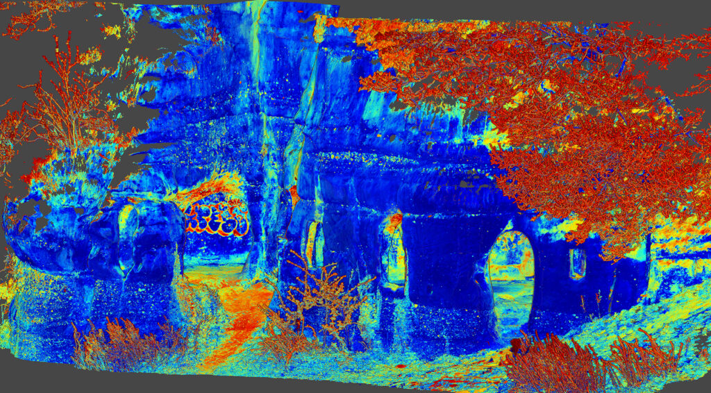
Colour intensity view showing hidden detail
Long regarded as an 18th century folly, a combined drone and laser scan survey that captured the surrounding area, external elevations and internal cave areas has revealed that this dating information maybe out by as much as 1000 years.
On the day of the survey work, the X9 Core was used over a period of hours with each scan taking 3-4 minutes to achieve the required density. Back at the office, Trimble RealWorks was used to combine the scan and drone data into a 3D model of the site which was then used for the creation of plans and cross sections.
By analysing the detailed point cloud data, particularly around the doorways and windows, the construction was found to closely resemble Saxon architecture whilst pillars were found to be similar to those in a Saxon crypt nearby.
The team was therefore able to deduce that the caves most likely dated back to the early medieval period, specifically the 9th century, rather than the 18th century, as previously believed.
The history of the surrounding area, including a nearby church and burial site, provided the RAU team with further evidence that the caves were very likely inhabited by King Eardwulf. He is believed to have lived there as a hermit after his exile from Northumbria in 806 and before he became known as Saint Hardulph.
For Mark, the information provided by the X9 Core scan has proved invaluable:
“It is extraordinary that domestic buildings over 1200 years old survive in plain sight unrecognised by historians, antiquarians and archaeologists. We were able to better understand how the structure builds up over time and hopefully one of the outcomes will be an increased level of protection. The reliability of the X9 Core and the speed with which it can deliver a 3D map on projects such as this is something we value highly.”
Multiple applications
Mark is quick to point out that the X9 Core is also earning its keep across a number of other RAU projects. These include finding a more accurate way to measure biomass, in particular for gauging carbon credits. Mark explains:
“In an industry worth billions of pounds, the traditional method of measuring a tree by holding up a stick and backing up 5 paces is simply not up to it. We’ve looked at drone surveys for this purpose and also used the X9 Core with interesting results confirming that the drone surveys are around 80% accurate compared to the scan data. We now have a useful choice between speed or high accuracy depending on the conditions. A lot of carbon offsetting is based on models with no precision behind them. We want to be more scientific about this and that’s exactly what the X9 Core will allow us to do.”
He concludes that “the X9 Core, widely regarded as an industry standard for 3D Laser Scanning, is the ideal tool for both teaching and research.” He hopes students will carry their knowledge of the system and its applications into the organisations they join, its ease of use making it well suited for bringing survey work in-house and therefore used more frequently.
*the X9 Core superseded the X7
For further information on Trimble Catalyst, please contact us here.
Using Trimble Catalyst to accurately map plots on their natural burial ground, Forget Me Not Fields has found a perfect balance between efficiency and tranquillity amongst the wildflower meadows.
Download a formatted PDF of the story here
In recent years, more people have been turning away from conventional burial practices and choosing alternatives that better align with their personal beliefs, attitudes toward death, and overall philosophy. This shift has driven a steady rise in demand for environmentally friendly options, particularly natural burial, as people seek to spend more time in nature when remembering loved ones.
Established in 2022, Forget Me Not Fields is one of these sites located on the Church Farm Estate in Wirral. A family run business for over thirty years, Church Farm is a perfect location for those seeking a natural burial based on its beautiful location overlooking the River Dee Estuary towards North Wales and has the benefit of already being well regarded by the local community through its award-winning family farm park attraction,
The idea of creating a burial ground emerged when the Ledsham family explored options following the loss of relatives. They realised that a natural burial ground could offer both environmental benefits and a more positive experience for those grieving.
Whilst a hands-on family concern, it is Director Matthew Ledsham who is responsible for the technical side of the business including the website, mapping, documentation and database. Whilst providing a warm and tranquil experience for those who visit is a priority, behind the scenes, it is the careful planning and use of centimetre mapping technology that keeps the site organised and running smoothly.
Choosing Catalyst – low-cost centimetre accuracy for non-surveyors
The 21-acre site consists of three former horse-grazing fields, beautiful open land, but with few distinguishing features beyond the boundary hedgerows making it difficult to get useful bearings. For Matthew, the challenge therefore lay in establishing a precise grid of 1.5 m × 1.5 m plots for ashes interments, and later larger burial sites, across this expanse. Whilst creating a map of the overall area proved relatively straightforward using Autodesk Civil 3D design software, locating an exact plot in the middle of such a large field remained problematic. He felt that the triangulation method commonly used at smaller sites would be impractical here and likely to require external expertise which he did not want to have to rely on.
Matthew then heard about Trimble Catalyst, a low-cost, high accuracy GNSS solution, through his AutoCAD contact. A visit to the KOREC Catalyst web shop supplied all the information he needed and he was able to easily select a suitable package comprising a low-cost DA2 GNSS receiver, a centimetre subscription based on hours of use and Soarvo Mobile software to run on his smartphone for collecting and viewing the map information.
Matthew selected the centimetre accuracy to ensure that he could maximise the number of plots by accurately being able to mark out burial sites with a sufficient buffer zone around them whilst keeping the site tranquil and organised.
“We knew Catalyst was the system we were looking for. This is a small family business where we wear many hats and therefore our days are carefully planned. I didn’t need centimetre-accurate positions all the time because I’d plan the mapping work in the fields every two weeks or so, over a couple of hours. The subscription package based on hourly usage was therefore great value.”
Stand out benefits of Catalyst for Forget Me Not Fields
Ease of use – Matthew has no previous survey and mapping experience
Accuracy – centimetre accuracy without having to pay for or set up a base station
Flexible subscription – extremely cost-effective for a system used for two hours every couple of weeks.
KOREC support – reliable with a high level of friendly assistance
Using the ‘Magic Stick’
Initially Matthew used the Catalyst system on a pole, known as the ‘magic stick’ for its problem solving functionality, but finding himself often kneeling on the ground to mark out plots, switched instead to using the system on a special short handle for ease of use and portability across the large site.
Adept at using technology, Matthew found the system easy to set up and use with a little assistance from KOREC’s technical support:
“There was definitely a learning curve because I’m not a surveyor and had no experience with this type of technology, but KOREC support talked me through any queries. Now we have a simple workflow in place for easily taking our maps out of Autodesk Civil 3D and prepared for use in the field on the Soarvo Mobile software with Catalyst. It’s second nature and couldn’t be easier!”
Future plans
Now an experienced user of the system, Matthew is finding new applications for it as they continue to work on the burial ground, mapping additional wildflower planting, new laybys etc.
He understands that for those considering Forget Me Not Fields, the experience is a very visual one with the views contributing to the tranquillity of the experience. He’s therefore looking at integrating his Trimble Catalyst solution with Trimble SiteVision, an advanced Augmented Reality (AR) system designed for visualising geospatial data in real-world environments. This would enable him to allow visitors to see the view from certain plot positions via information sent by email if they are unable to visit the site in person.
He concludes:
“If I had to highlight one standout benefit of the system, aside from the customer service from KOREC, it would be its ease of use. Once you’re up to speed, it takes me less than an hour to assign a task, navigate to the plot and begin work. This maximises my time in the field, which is crucial when we’re such a small but busy team.”
For further information on Trimble Catalyst, please contact us here.
Lloyds Datum Group (now part of SOCOTEC UK and Ireland) has pioneered a landmark project on an abandoned mine site in Northern Ireland.
It is the country’s first large-scale ground stabilisation monitoring initiative to use Worldsensing’s GNSS Meters, new wireless sensors that combine high-precision GNSS positioning with an integrated tiltmeter.
Download a formatted PDF of the story here
Established in 2004, Belfast based Lloyds Datum Group (LDG Datum) specialises in foundation testing, structural monitoring, geotechnical services and related civils work. Under Director Mark Hodgen, the company has built on its reputation for trusted advice and innovative technology with Mark working closely with both customers and suppliers across all areas of the business.
This practical mix of hands-on experience and focus on what clients actually need, along with an ethos of working with new technology, has led to them working closely with KOREC to become the first company in Ireland to use Worldsensing’s new GNSS Meters on a mass project.
Project background and site concerns
As the owner of Northern Ireland’s 2,400 abandoned mine workings, the Department for the Economy (DfE) carries out a comprehensive mine monitoring programme and implements mitigation measures where required. Over a number of decades, the DfE has faced ongoing challenges regarding ground stability at three abandoned mine sites in Carrickfergus: Maiden Mount Mine (closed in 1958), French Park Mine (closed in 1952), and Duncrue Mine (closed in 1938). These historically significant reminders of Northern Ireland’s strong salt mining heritage are affected by substantial underground voids created through decades of extraction. Consequently, there have been reports of ground displacement dating back as far as 1896 at the Duncrue mine.
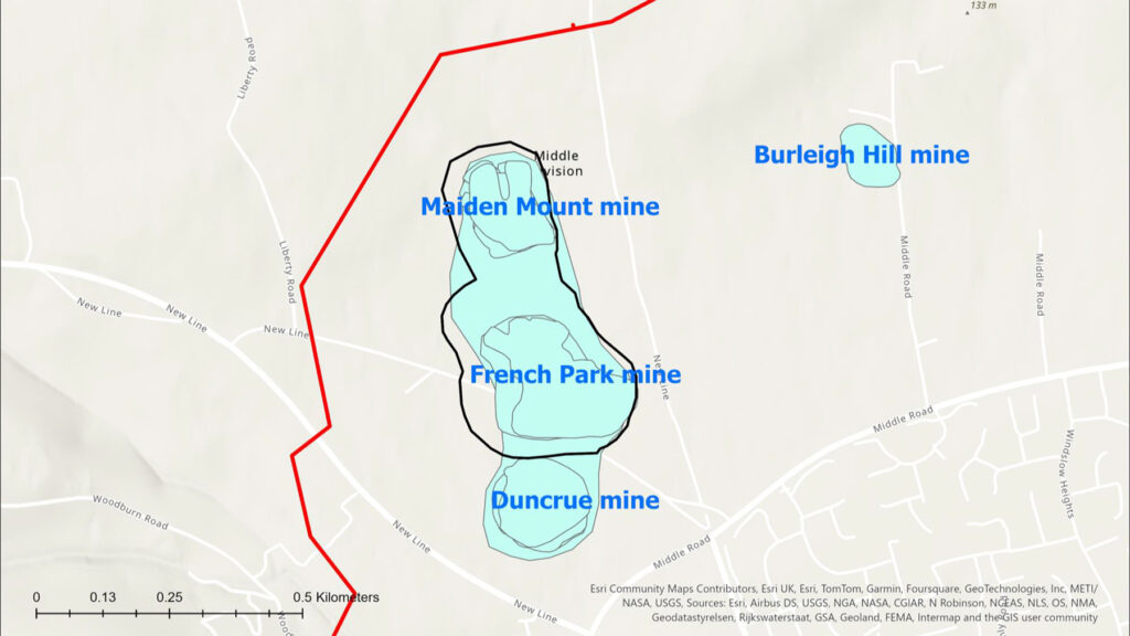
Area covered by the three mines
The site has therefore been monitored regularly since 1990 using manual topographical surveys and LiDAR aerial photography, methods that despite being time-consuming and costly (running into millions of pounds per year), have been relied upon for many years.
However, in its efforts to assess the stability of lands adjacent to the mine, the DfE wished to provide further assurance within a wider monitoring and assessment programme which would include the recording of long-term ground stabilisation patterns over the mine site and adjacent lands by significantly increasing the amount of high-quality data collected, all backed up by regular reports.
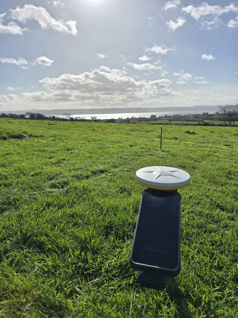
Already familiar with Worldsensing tilt-meters, LDG Datum were perfectly positioned to work with supplier KOREC and develop a proposal for a low-cost, highly accurate network of sensors to run as a comprehensive two-year monitoring programme, with potential flexibility for extension.
These sensors would be the newly released Worldsensing GNSS meters which feature advanced multi-band RTK technology and innovative edge processing for millimetric precision with great reliability.
Additional challenges
Whilst the site already presented complex geological challenges that would require real-time millimetre precision monitoring, Mark and the LDG Datum team also had to contend with a number of additional considerations:
Access restrictions – although the area over the mines is owned by the DfE, the wider area to be monitored has multiple owners with some of the land used for agricultural livestock.
Site size – covering such a large area, the solution would have to be cost-effective, provide high accuracy data, have minimal maintenance requirements and offer reliable, long-range wireless communication in a rural location.
Weather conditions – equipment would have to be suitable for an open site that can be subject to extreme wet and cold as well as storm events.
Cost-effective – any system would have to provide high-level monitoring information as specified by the DfE but also provide value for the taxpayer. Alternative survey methods would require two people visiting the site daily – an extremely heavy demand on resources and budgets.
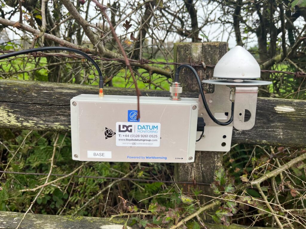
To meet these requirements, LDG Datum implemented an advanced GNSS-based monitoring solution featuring the deployment of twenty-two Worldsensing GNSS Meters strategically positioned across the three mine sites.
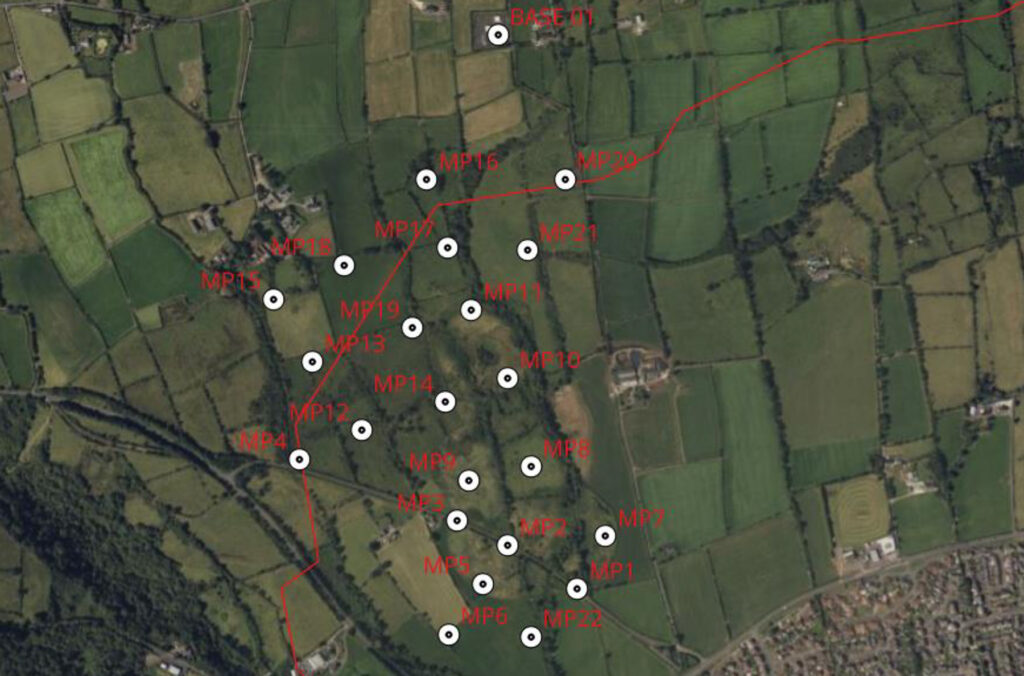
The flexible configuration of the meters allowed a twenty-third unit to serve as a base station, significantly reducing overall costs. All data is wirelessly transmitted to Trimble’s T4D monitoring software for visualisation, analysis, and reporting.
Using the GNSS meters
LDG Datum was provided with a map and GPS coordinates and Mark and his team positioned the twenty-two sensors at strategic locations across the sites using 550 mm screws. The base station sensor was mounted on four Kelly blocks on hard standing ground at the top of a hill.
A central gateway system was also installed to enable data collection and transmission, supported by a solar panel setup to ensure autonomous, continuous operation throughout the project’s lifecycle. Data is relayed once an hour, with reports generated in Trimble T4D and sent to the client daily.
Pioneering scheme
The scheme was established in October 2025 and with it now firmly established and running to plan, Mark reports that it has been extremely well received.
“Worldsensing’s GNSS Tilt Meters have enabled us to deliver essential ground stabilisation data, which we can use for evidence-based decision-making regarding land use planning, development restrictions and potential remediation strategies. The client is very satisfied with both the level of information provided and the value for money.
“The project’s potential for extension demonstrates its value in providing ongoing surveillance of these historically significant but potentially hazardous sites, contributing to enhanced public safety and informed infrastructure planning decisions.”For further information on any of these products, please contact us here.
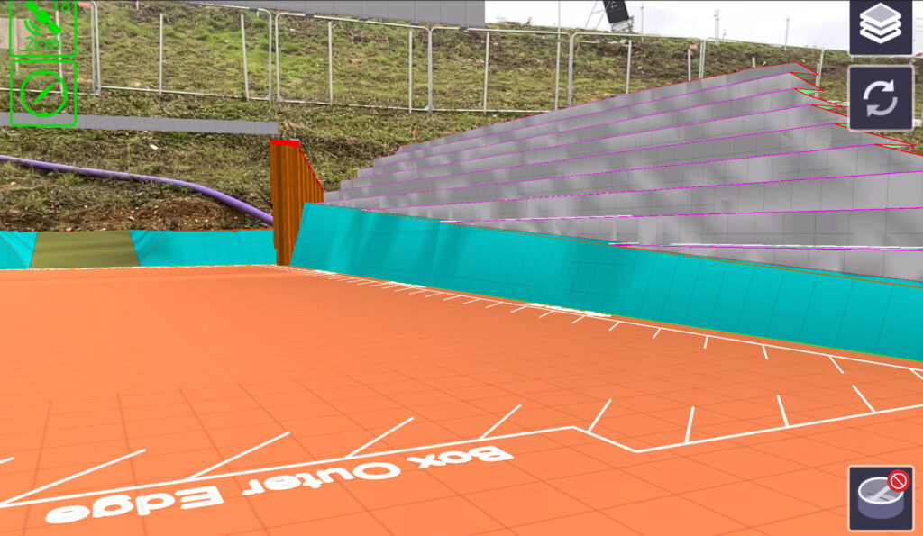
Leading earthworks and civil engineering contractor MJ Church, has combined its holistic, model-driven approach to complex infrastructure projects with a fully integrated Trimble ecosystem of hardware and software – all hosted within Trimble Connect’s Common Data Environment.
The outcome: An exceptional level of operational control that enabled the team to complete the excavation and backfill operations (required for an innovative ‘box slide’ installation) a full day ahead of the scheduled nine-day Christmas possession. This work was carried out on the complex M27 Junction 10 Improvement Scheme in Hampshire.
Download a formatted PDF of the story here
Digital-centric approach for a complex project
Scheduled to finish in 2026, this project is being delivered by Hampshire County Council, working closely with National Highways appointed main contractor VolkerFitzpatrick, and earthworks and civil engineering contractor, MJ Church.
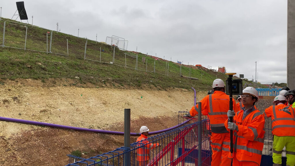
The design of the M27 Junction 10 improvement scheme, which includes a new motorway underpass and three new slip roads to support the new Welborne Garden Village, was determined by National Highways’ decision to adopt the innovative ‘box slide’ construction technique for the underpass. This approach required the excavation of approximately 22,000 m³ of clay and chalk to create a safe working void for the installation of the 8,500-tonne reinforced concrete underpass structure via hydraulic jacking.
The nine-day possession of this eight-lane section of the strategic road network meant that contractors had to meet strict-deadlines with no margin for error – a challenge that placed a strong emphasis on planning, collaboration and data accuracy.
Key to the precision and efficiency with which this section of the works was successfully executed was the MJ Church digital-centric approach led by Construction Technology Lead, Sam Lemon.
Responsible for all the model’s updates and the survey, volumes and drone data used to refine it, Sam saw that the constant flow of information between site and office as a vital aspect in establishing the model as ‘a single source of truth’. He delivered this by establishing Trimble Connect as the common data environment (CDE) for the project.
Meeting project challenges with the 3D Model
For Sam, the complexity of the project presented significant pre-construction challenges: How can we prove that the box slide will be successful? How can we demonstrate this approach to the client and stakeholders and win their confidence? Is this actually buildable? And more specifically during the works: How can we ensure that the skilled machine operators have a full understanding of the data they are working with? Is the survey correct? Are we confident in the expected volumes and therefore achievable outputs? Can we fit these machines into this space safely and what plant is suitable for that width?
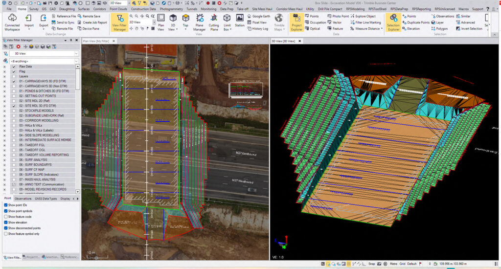
Trimble Business Center was used to create the 3D model
MJ Church’s solution to these questions, and many more, was to fully model the construction phases in Trimble Business Center (TBC) software. All survey data, including the original topo survey, along with inputs from other sources such as their DJI Mavic 3 Enterprise drone, was seamlessly imported into this platform.
Working collaboratively with VolkerFitzpatrick, Sam took the initial linework Civil 3D model and transformed it into something from which the machine operators could derive real utility, refining it over 6 iterative versions into a highly detailed, risk-mitigating end result. This model served every stakeholder and provided the essential foundation for the digital rehearsals conducted ahead of the 19-phase excavation.
Democratising the model with TBC
True to MJ Church’s ethos of geospatial data democratisation, the model was transformed in TBC from initial outline design, into a holistic tangible model that was accessible, communicable and usable by every stakeholder.
Sam drew on his extensive knowledge of Trimble Business Center software for processing and modelling geospatial data and used this to ensure that each of the models created for the works, including the advanced offline earthworks, controlled possession excavation, and multi-material backfill operations, were developed with the specific needs of the machine operators in mind.
He used extensive detail including colourisation, text, slope lines and easy hosting of the 3D IFC file for the box to interrogate the model relatively. He also spent some time on simple details such as making the bottom of the bench green and the slant of the bench grey for easy identification.
The high quality of the models generated in TBC resulted in excellent feedback from downstream users, with Sam explaining:
“TBC has one of the best and most robust 3D engines on the market, invaluable for interrogating and manipulating all types of geospatial data in full 3D alongside other assets. I cannot think of a better tool on the market for doing that work. It’s a drag and drop environment that can basically handle anything. When the client sends an IFC file of the structure, I can drop that in. If it’s a point cloud collected from the drone, that also goes in without any hassle. Trimble has really thought about TBC from a construction model point of view.”
Soarvo data sharing and handling cloud software added a highly visual aspect of the planning and checking process by bringing the scale to life and assisting with material planning movements.
The completeness of the 3D model enabled the team to pre-empt problems and optimise the design ahead of the works. In one example anticipating undesirable weather, alterations were made to the model to introduce a 1.5% longitudinal fall into the benching excavation, allowing the rainwater to be managed towards pumps if required.
In another example, Sam used TBC’s powerful corridor tools to create the H:1.50m x V:1.0m benching geometry. These tools allowed the work in progress model to remain dynamic and easily editable as the planned design was collaboratively optimised in consideration to other constraints. A separate corridor was created for the East and West benches, and it was quickly identified that the benches could not run parallel with the formation excavation due to the varying elevation on the expected clay and chalk strata and the interface with the 70° sidewall at the base of the excavation. Thus, the azimuth direction was skewed independently on each side to optimise the intersect line. This reduced the excavation volume required under possession as much as possible.
Streamlining project collaboration with Trimble Connect
Throughout the project, Sam has underlined the importance of having a single source of truth where everyone can view, share and access project information from anywhere, at any time. Central to this process has been Trimble Connect:
“By using Trimble Connect as the host for our model and all the geospatial data, we removed the irritating process of constantly asking ‘which model… is it this one?’ whilst looking at it through somebody else’s Teams or a native software that simply couldn’t bring the data to life. Our approach is to be as transparent as possible, all agreeing from the same source in the same environment. I like to think of our approach as practical BIM without the unnecessary bloat”
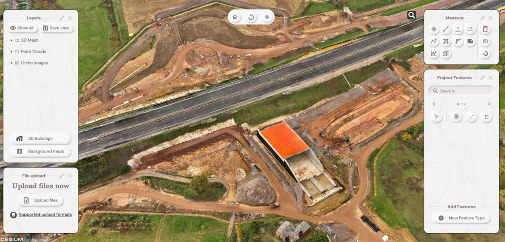
Above and below – Trimble SiteVision was used for for enhanced on-site visualisation, clash detection and decision support,
Handling over 45–60 file formats (including IFC, DWG, PDF, point clouds, geospatial data, and Trimble-specific formats), and with strong 3D viewing capabilities, Trimble Connect served two clear functions on this project: Firstly, as a folder structure for the Trimble Access field/survey software to dial into and pull data across and secondly, as a collaborative CDE for planning and hosting the digital rehearsal process which was a significant element in the project’s success.
Trimble Connect enabled a smooth flow of information across the Trimble eco system which included:
- Trimble R980 GNSS Rover used for checking the control network, setting out, grade checking and recording as-builts. These GNSS rovers and on-machine MS976 receivers were selected for dependability and in particular, the ProPoint technology. ProPoint brought robust performance on a site with many potential degradation issues such as moving machines and working in an excavation up to 10m in depth.
- Trimble R750 Base Station, which served RTK corrections to both the GNSS Rovers, UAV platforms and Machine Control systems via UHF radio and NTRIP in an RTCM formation to increase compatibility.
- Trimble Earthworks Machine Control and WorksManager software for centimetre-level accuracy in excavation, grading and material placement.
- Trimble SiteVision mixed reality technology for enhanced on-site visualisation, clash detection and decision support, turning a complex piece of work into something tangible and rapidly increasing understanding of the project for those not present full time.
- Trimble Business Center for processing field data, model refinement, surface generation, volumetric quantification and quality assurance.
- Trimble Access field survey software and TSC7 Logger for synching with the model via Connect. If a change is made in the office, it efficiently propagates down to the site team eliminating setting out errors emanating from potentially incorrect file revisions – no need for USB sticks.
- MJ Church also used a KOREC supplied DJI Mavic 3 Enterprise drone and Soarvo data sharing and handling cloud software. Together, they provided an additional highly visual aspect of the planning and checking process by bringing the scale to life and assisting with material planning movements. In Teams meetings, Sam could use Soarvo to spin the whole 3D model to explain plant access, stockpile locations etc.
De-risking with digital rehearsals
At MJ Church, the digital rehearsal begins before any ground is broken. Using the detailed 3D models developed in Trimble Business Center and shared via Trimble Connect, the company brought together operators, engineers, and supervisors for virtual walkthroughs ahead of the day’s planned activities. Each session was based on an extensive handbook that clearly defined the construction sequence, eliminating any ambiguity around the design and its implementation.
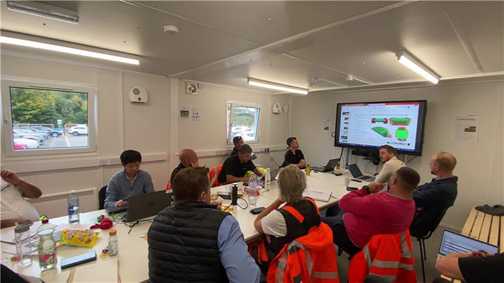
Start-of-shift-briefing
These start-of-shift briefings provide essential clarification of the planned work while reinforcing all health, safety and environmental considerations, ensuring no confusion arises during high-pressure operations. Above all, they served to de-risk the activity from three key perspectives: planning, personnel, and geometry.
Project success and future vision
Following the nine-day Christmas possession, the M27 Junction 10 project was completed successfully a day ahead of an extremely tight schedule. The high level of detail invested by MJ Church in its digital-centric approach was a strong factor in this achievement.
Following his experience on this project as well as earlier ones where the same approach was used, Sam feels that creating an environment where everyone is involved in the model through Trimble Connect really pays dividends. All stakeholders gained clarity and full understanding of these complex works which contributed greatly to the success of the operation. MJ Church is continuing this approach onto one of their next projects on the A47 Thickthorn Junction scheme in Norwich. He concludes:
“KOREC has been an exceptional partner with superb customer service, and knowing we can rely on them to supply the right kit, at the right price, with all the options we need; that it will work, and that it will be fully supported has been an important aspect of this project’s successful delivery.
Trimble’s technology has also had its part to play. Trimble has really thought about it as a platform with a holistic portfolio of products that integrate with each other. This means we’re not battling the platforms to get the output – I know that any work I do in TBC will seamlessly work with Trimble Earthworks, Trimble Connect, Access and SiteVision. We will continue to take this approach in future projects and hope that the results on this project will encourage others to develop a holistic model-driven approach.”
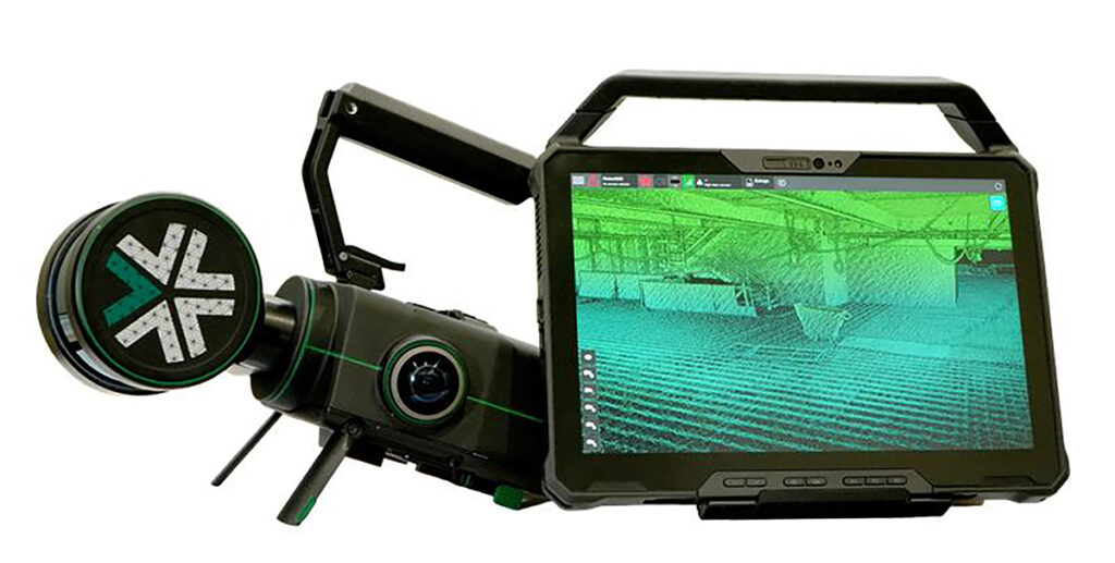
When Neon Surveys introduced the Exyn Nexys SLAM system into their floor-plan surveying workflow, the only difference their clients noticed was how much faster they received the finished deliverable.
Established in 2012 by Director Duncan Hallam, Neon Surveys specialises in measured building, topographical and referencing surveys. From the company’s outset, Duncan has invested heavily in innovative hardware and production software to maximise efficiency and find ways to eliminate the traditional obstacles that regularly impeded his team’s progress. In particular, during floor plan work, the same challenges would recur such as time pressures, tenants who couldn’t be disturbed and increasingly complex internal layouts.
Data captured at the industrial building project in Warwickshire
As a skilled user of 3D laser scanners, he therefore recognised that SLAM technology would be an ideal match for these precise floor-plan surveys that made up a large share of the company’s workload and successfully integrated two system into the Neon workflow five years ago.
In 2025, with the Neon Surveys team continuing to grow, Duncan felt it was the right time to supplement their two existing units with a new SLAM system, one capable of elevating data quality and offering a practical alternative to terrestrial laser scanning in certain scenarios.
Three-way synergy
After extensive research, Duncan and fellow Director, Will Jordan, felt that the combined support from Exyn and KOREC, along with Exyn’s openness to shaping future developments around user feedback, made the Nexys and its functionality an ideal fit.
Duncan trialling the Nexys with KOREC
By working closely with Exyn, he and Will have now fine-tuned the Neon workflow to the point where drift is minimal, even in the particularly challenging internal environments they work in. Both Duncan and Will have also benefited greatly from sharing their experiences with KOREC and drawing on the KOREC team’s support and industry knowledge.
Duncan and Will say that, thanks to the reliable support and their own growing expertise, the Exyn Nexys is now deployed several times a week with almost zero downtime and has become the go-to tool for their internal surveys in offices and retail spaces.
A recent project in Warwickshire perfectly demonstrated just how indispensable the Nexys has become.
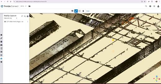
Twenty-seven acre industrial site in Rugby
A large, sprawling industrial site in Rugby, manufacturing parts for power stations and filled with machinery, presented the Neon team with a number of challenges when they were contracted to produce a floor plan/sqm for potential refurbishment.
Due to sensitivity around the industrial parts the site was producing, the client had imposed certain restrictions. Although they were comfortable with Duncan walking around the site, he had to stick to safe walkways and also be escorted at all times. Additionally, Duncan would be just one person in a four strong survey team carrying out supporting work such as environmental surveys. It was therefore imperative that, with just one escort for all of them, he was not holding anyone up despite the amount of data he needed to capture.
Finally, it was esential that the tenants were not disturbed. Typically, the tenants want the surveyor to be silent, not involved in lengthy instrument set ups and offsite as soon as possible. Both Duncan and Will have noted that using the Nexys on this type of job has enabled them to keep the process both fast and quiet, something appreciated by client and tenant alike.
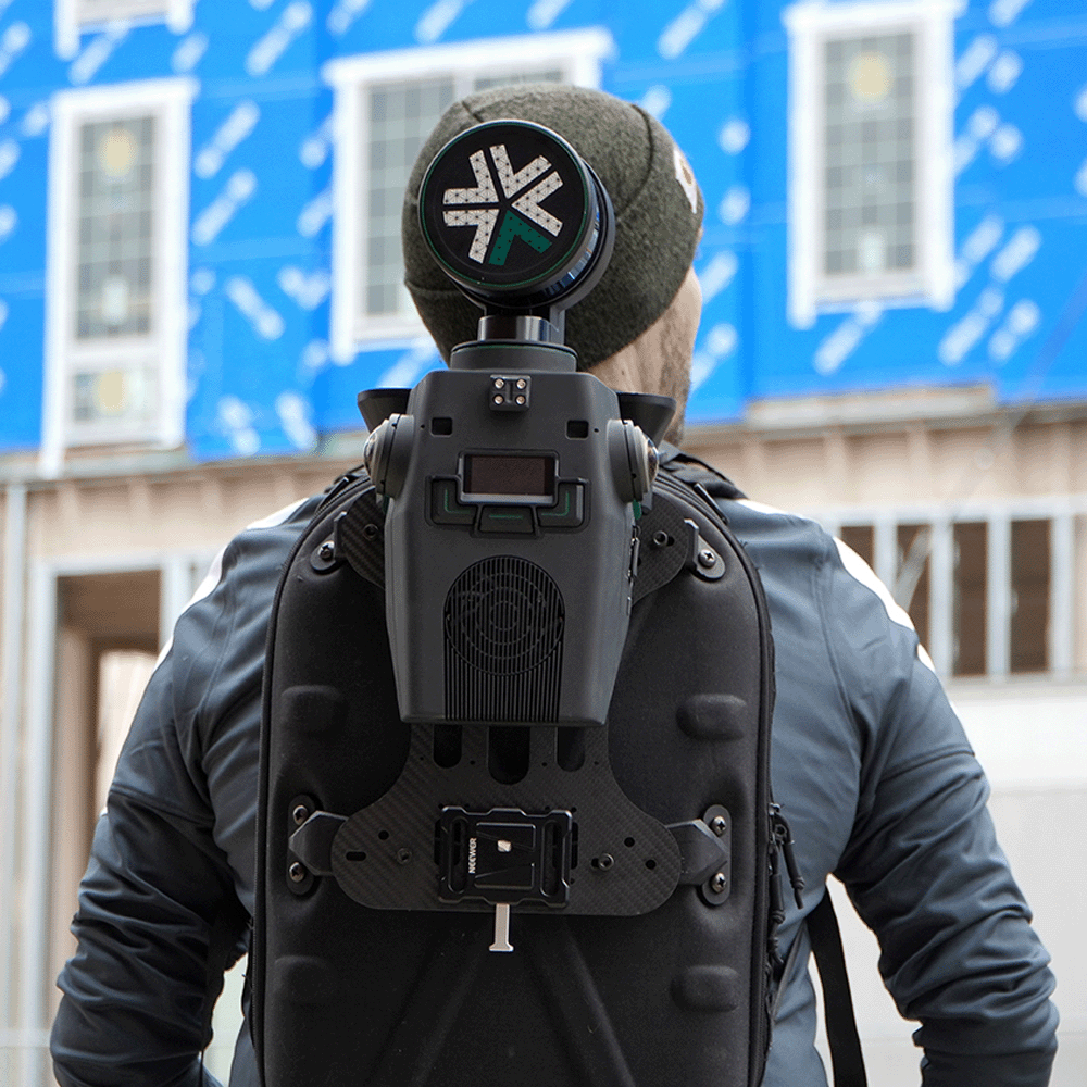
On the day of the survey, Duncan mounted the system in a backpack and walked over 10km around the 27 acre site capturing all the required data (well within 15-20mm accuracy specified for the job) in a single day:
“Our aim is always to get high-quality data into the hands of the client as quickly as possible. On this project, we spent one day scanning, the next day processing and the third day drawing up. If we’d used a 3D Laser Scanner we’d still be on site.”
Data captured at the industrial building project in Warwickshire
In-house data processing “a priority”
Unlike other SLAM systems, the Nexys generated data is owned by Neon and can be processed in-house – a priority for Neon. With full control over the data, they know exactly what the cost of processing will be and can factor in how long it will take. Whilst Duncan and Will acknowledge that other systems that process the data in the cloud can be a little quicker, they find the time difference negligible, enjoying that they can choose the level of refinement required depending on the nature of the project. Duncan notes:
“Cloud processing is done at certain settings. Having the choice to change these, depending on the job, ensures our clients get the perfect balance between speed and accuracy along with the added security that we can do this off-line.”
Why Neon rate the Nexys
- Reliability – before purchasing, Duncan completed a particularly challenging walk, looping through office and entering and exiting via different doors:
- “The SLAM held – I’ve never had a SLAM do that and have next to zero drift on the data.”
- Data quality – the rotating head provided great coverage and good looking scan data.
- Quiet operation – compared to other SLAM’s the quiet operation of the Nexys has ensured that work can be carried out without disruption to building occupants.
- Data ownership – perpetual license for security and choice over data refinement levels
- Flexibility – Duncan often undertakes longer walks with the Nexys in a backpack whilst others prefer to carry it in front of them as they walk. (The system can also be drone mounted.)
- Colourised data – Will finds the amount of data you can see from the pictures overlaid on the point cloud is ‘night and day’ compared to other SLAM systems.
- Generic batteries – caught out and you can buy them at a shop.
Duncan concludes:
“Compared to other SLAM systems and compact 3D Laser Scanners, the Nexys SLAM works noticeably better and jobs that would have taken hours are now completed in minutes. Importantly, our clients have made no comment on the data compared to data we have supplied by a laser scanner. What they have noticed is how much faster they receive the deliverable.
“What do I like about the Nexys in particular? Is there an option for everything!”
What Neon Surveys rates:
- Reliability – the SLAM held with virtually zero drift
- Data quality – rotating head provides great coverage
- Quiet operation – clients and tenants greatly value that Neon is not disrupting building occupants
- Data ownership -for security, cost control and choice other refinement settings
- Flexibility – can be backpack mounted or handheld
- Colourised data – superior to other systems
Discover SLAM
Talk to a scanning expert
Get in touch with one of KOREC’s friendly laser scanning specialists to see how SLAM scanning can improve your workflows


About the Exyn Nexys
SLAM (Simultaneous Localisation and Mapping) mobile mapping systems integrate LiDAR sensors with inertial measurement units (IMUs), cameras, and algorithms to build a 3D map in real-time while the device moves.
With Exyn Technologies’ Nexys expect survey-grade LiDAR + proprietary SLAM algorithms that deliver industry-leading data capture speeds, real-time colourisation, on premise post-processing, and instant onsite visualisation in a variety of physical configurations, levels of autonomy, and environmental conditions.
Whether mounted on a drone, vehicle, handheld device, or ground robot, it adapts to different industries, from mining to construction and geospatial surveying. Nexys provides accurate spatial data without relying on GPS, making it particularly effective in underground or obstructed areas where traditional mapping tools struggle.
Download a formatted PDF of the story here
How a strong understanding of the Exyn Nexys SLAM technology enabled SYSTRA UK to strike the perfect balance between speed and accuracy during a recent structural assessment survey of a large and complex building in Manchester.
Download a formatted PDF of the story here
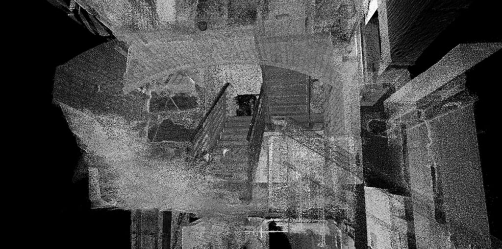
Data captured with the Nexys showing stairways
Site challenges and survey constraints
In the heart of Manchester’s busy city centre, a historic building on a well-used thoroughfare is set to undergo structural alterations. From a surveying perspective, the site presented numerous challenges for the appointed contractor, SYSTRA UK, a global design powerhouse and one of the world’s leading engineering and consulting groups specialising in public transport and mobility solutions.
Architecturally complex, the building comprises a mixture of small and large rooms, irregular geometries, long corridors, varying floor levels, and extensive internal clutter including scaffolding and temporary supports. Whilst parts of the building stand vacant, other areas remain fully operational, occupied by office staff. The client requested minimal disruption in these main areas throughout the survey, a requirement that risked limiting access times, particularly if multiple instrument setups and heavy tripods were needed.
For the SYSTRA UK team, led by Senior Survey Manager Tomek Koniuszy, a further challenge lay in meeting a tight deadline to produce a comprehensive point cloud. This dataset would underpin the creation of an accurate floor plan and a detailed structural assessment survey and serve as a baseline for future works.
SLAM technology or 3D laser scanning
Whilst assured that he could create a high-quality millimetre accurate point cloud with a laser scanner (which would over deliver on this project), Tomek was aware that this could take up to five days and disrupt the occupants with the placement of targets and multiple time-consuming set ups to accommodate the complexities of the building. With all the internal scaffolding, shadowing could also be an issue because it was imperative that the point cloud was clean.
Consequently, Tomek immediately considered employing a SLAM system. Despite being relatively new to the technology, he believed that the balance between its advantages – notably speed and flexibility – and the level of accuracy it could achieve strongly favoured its use for this project.
However, he did anticipate some initial challenges in convincing a client accustomed to working to millimetre tolerances for high-accuracy survey and rail applications to adopt a workflow designed to deliver less accurate data, although still within the project’s requirements.
Choosing the Exyn Nexys
Seeking more information about the technology, Tomek conducted online research into potential SLAM systems and soon came across KOREC’s newly announced partnership with Exyn Technologies and their Nexys modular 3D mapping solution. After a brief demonstration, and confident that KOREC would provide a high level of support throughout the project, Tomek felt fully assured in his decision to proceed with the system.
Also, key to Tomek’s decision to go with the Nexys rather than another system was data ownership:
“I want to own my own data. I don’t want a third party to have it. This was very important to us.”
Just half a day required
Before the building was surveyed, control was established outside, rather than inside, which the SYSTRA UK team felt was a notable gain. This was backed up by retro targets around the entry and exit points.
A SYSTRA UK surveyor, with a member of the KOREC team advising, then completed the survey using the Nexys system in just half a day rather than the five days estimated for the use of a laser scanner. This efficiency was further enhanced by the system’s ability to display scans in real time, allowing the team to verify completeness in the field and minimise the need for rework.
As Tomek explained:
“Once in the building we could go anywhere with minimal disruption to the occupants. Behind a wall, under a table, down dead ends, along corridors…anywhere. Capturing all the data we needed for a clean shadow free point cloud couldn’t have been easier.”
Accuracy verification and quality assurance
The captured data was then processed with the assistance of KOREC. Tomek provided accuracy assurance for the client by reporting on previously coordinated scanning targets positioned around the building. These control targets were registered by the Nexys within a range of 5 mm to 20 mm in 3D when compared with the terrestrial scans. This was deemed sufficiently accurate for the project’s requirements.
Further accuracy validation was achieved through common points identified between the terrestrial scans (based on survey control) and the Nexys point cloud. Tomek was aware that the Nexys technology would allow him to adjust to control, but did not consider this necessary having achieved “an excellent result considering the type of technology employed.”
Finally, the client carried out an in-depth review of the dataset, confirming the overall reliability and precision of the results.
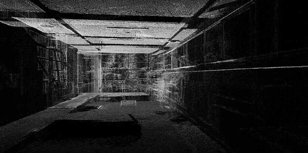
Data captured with the Nexys showing different floor levels
Balancing benefits and accuracy
For Tomek, the advantages delivered by the Nexys system on this project far outweighed the loss of using a static scanner and achieving a millimetre-accurate point cloud. Basically, he could scan 20x times faster than a terrestrial scanner at the expense of around 15mm of accuracy.The key benefits included:
- The entire building was surveyed in just half a day, compared with the five days estimated for a traditional laser scanning approach.
- Accuracies were within the required tolerance with minimal drift. (±1 cm accuracy, environment-dependent, and refers to spatial mapping precision for 3D point clouds, not raw sensor range).
- Minimal disruption to occupants, allowing the survey to be completed during normal working hours.
- Little to no shadowing, resulting in a clean, comprehensive point cloud.
- The technology proved extremely intuitive and easy to master.
- Exceptional versatility and speed, even within the building’s complex layout.
Tomek concludes:
“The client was impressed when we demonstrated how the point cloud data had been captured, and for us, working under tight time constraints, the Nexys was an excellent solution. Not every project requires millimetre-level accuracy, and in this case, there was a compelling reason to use a slightly less precise platform. In short, it was a godsend -it truly made the difference between make or break for us.”
About the Exyn Nexys
SLAM (Simultaneous Localisation and Mapping) mobile mapping systems integrate LiDAR sensors with inertial measurement units (IMUs), cameras, and algorithms to build a 3D map in real-time while the device moves.
With Exyn Technologies’ Nexys expect survey-grade LiDAR + proprietary SLAM algorithms that deliver industry-leading data capture speeds, real-time colourisation, on premise post-processing, and instant onsite visualisation in a variety of physical configurations, levels of autonomy, and environmental conditions.
Whether mounted on a drone, vehicle, handheld device, or ground robot, it adapts to different industries, from mining to construction and geospatial surveying. Nexys provides accurate spatial data without relying on GPS, making it particularly effective in underground or obstructed areas where traditional mapping tools struggle.
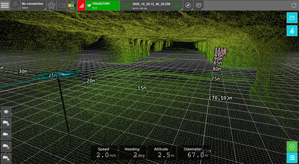
Example of live fast colourisation of the Exyn Nexys Pro point cloud data from another project
A family farm has diversified into providing an expert soil sampling and analysis business as an independent alternative to using services provided by large agricultural chemical companies. At the core of their testing process is a cost-effective Trimble GPS system delivering guaranteed accuracy.
Download a formatted version of the story here
Based in Northamptonshire, Agri Soil was established in 2023 to bring independence and expertise to agricultural soil sampling. The company emerged from its founders’ own need for reliable, unbiased soil analysis that was free from the commercial interests of the chemical suppliers who often undertook this work.
Recognising that many local farmers shared the same demand for impartial insight, Agri Soil’s initial offering included a range of soil sampling services from basic analysis looking at pH and levels of key nutrients in the soil through to more specific testing on organic matter and trace elements.
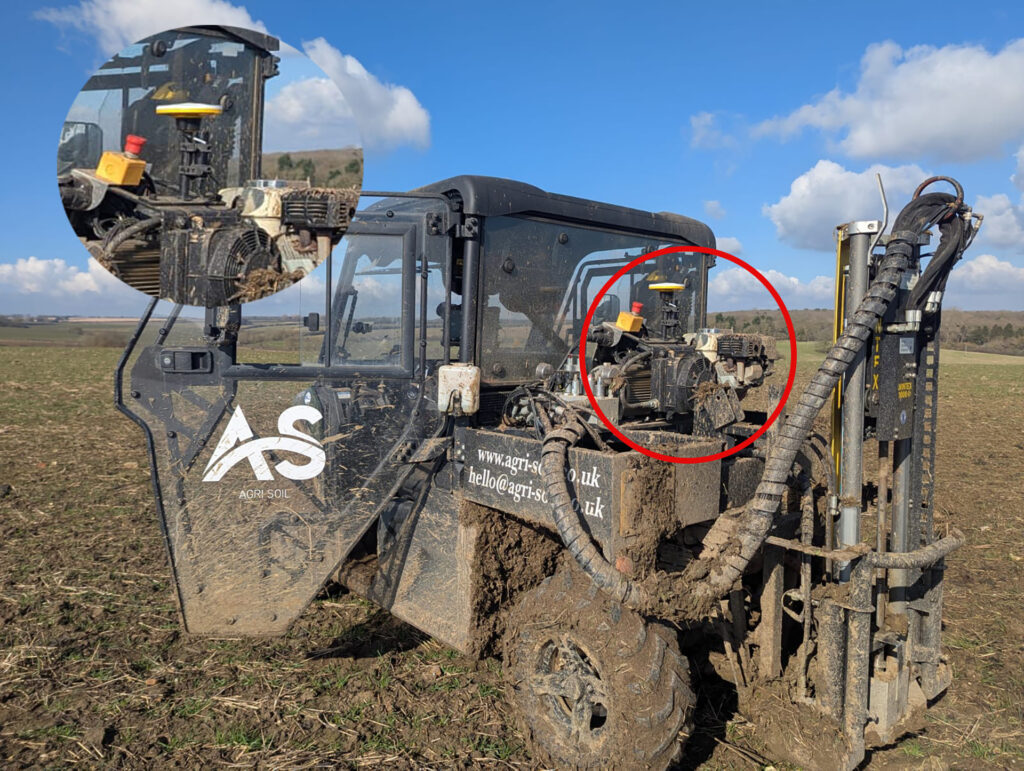
With its core services established, Agri Soil was able to secure government funding to invest in relevant equipment including a Utility Terrain Vehicle (UTV), enabling them to deliver professional, data-driven soil testing across the region.
Catalyst benefits for Agri Soil:
- Flexibility at a reasonable price – option to buy hours rather than a monthly subscription
- Guaranteed accuracy for peace of mind and client confidence
- Maintains positioning even in areas with weak or no signal,
- No heavy upfront costs (the Catalyst DA2 receiver costs less than £350)
- Portable for easy removal or swapping onto customised UTVs
- Ability to manage multiple licenses from a single account
- Easy set up and intuitive to use
- Responsive support from KOREC
Required accuracies and how to achieve them
Initially, the sampling site locations were recorded using a basic low-cost Garmin GPS linked to an iPad. However, Agri Soil co-founder, Francesca Ashby quickly recognised that as the business expanded, particularly into areas such as carbon testing, greater positional accuracy would be essential.
“Whilst the Garmin served us well for most tasks, offering an accuracy of around +/- 2 metres, this simply wasn’t sufficient for the more demanding carbon testing protocols which required verifiable, consistent, repeatable positioning.”
With a knowledge of precision farming, Francesca was well aware of what advanced GPS technology could offer. She began exploring alternatives that would provide reliable, sub 2-metre accuracy without the high upfront costs of the RTK-grade systems used on tractors. Following a recommendation, she approached KOREC to learn more about Trimble Catalyst, a flexible, subscription-based GNSS solution that offered the guaranteed precision Agri Soil needed at an affordable price.
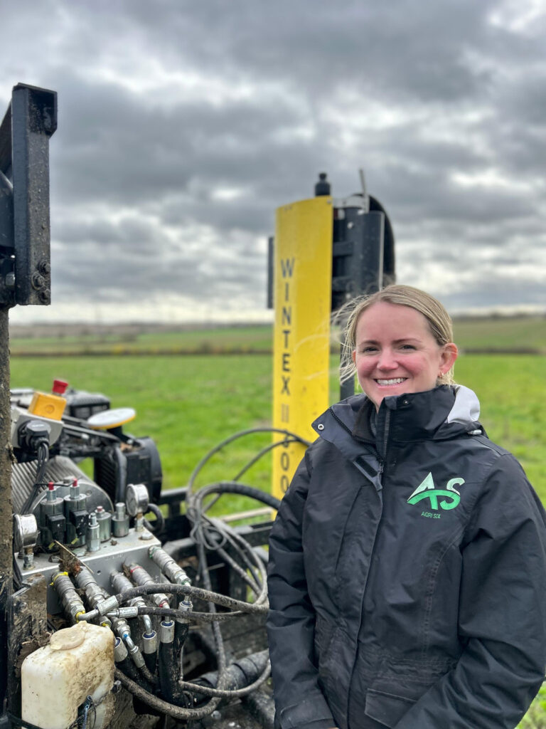
Agri-Soil Co-founder, Francesca Ashby
Guaranteed accuracy supports new applications
Francesca therefore invested in two cost-effective Trimble DA2 Catalyst receivers, each priced at under £350, and opted for the 60 cm accuracy subscription. By purchasing a usage-based package tailored to their projected daily workload, Agri Soils ensured they would only pay for the hours required for their soil sampling service whilst retaining the flexibility to accommodate additional needs. For example, recording temporary features such as a muck heap not visible on aerial imagery, which might prevent sampling at a particular location.
All collected data can then be seamlessly uploaded to Agri Soils’ GIS platform, clearly displaying which areas have been sampled and which remain outstanding.
Additionally, the subscription’s flexibility has enabled Agri Soils to explore new business opportunities without the need for a major upfront investment. By purchasing additional hours at higher accuracy levels, the company can now offer a precision boundary mapping service allowing farmers to update existing maps and gain a clearer understanding of their land boundaries to support more accurate yield assessments and farm planning. Francesca concludes:
“Our goal is to help farmers understand the health of their soil without selling them any products ensuring they can place complete trust in our independent findings. What we value most about Trimble Catalyst is its guaranteed accuracy and repeatability, which provides peace of mind both for us and for our customers. The flexibility of the subscription model also allows us to explore new applications and opportunities helping our business to continue growing.”
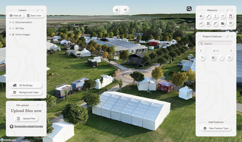
Contact us for further informationGrowing a business through clarity: How Image Surveys used Soarvo, a cloud-based 3D geospatial platform, to make 3D drone data interactive and easy to share for all of an events management team.
Download our formatted PDF of the story here
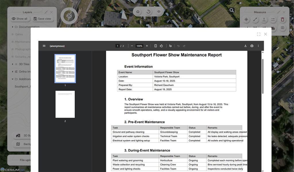
The popular seaside town of Southport is famous for many attractions including its stunning Victorian architecture and vast beaches as well as being home to the largest independent Flower Show in the UK hosted in the town’s Victoria Park. The park is privately managed, leased from the local authority and managed by Southport Flower Show who are a registered charity.
The park is self-financing based on revenue raised from a number of large events during the year run by 3rd parties hiring the venue assisted by the Southport Flower Show events team and include concerts, motor shows, caravan rallies and comedy festivals. However, the largest event and the one run by the venue team itself is Southport Flower Show, which has run since 1924 and attracts around 50,000 visitors each year. The show brings together many attractions and 300+ traders.
From 2D to 3D
With no other sources of income or grants, the charity relies entirely on delivering excellent planning and organisation for both exhibitors and visitors. Initially, they felt that updating their old 2D plans would provide all the information they needed to do this, albeit in a fairly standard, architect-style format.
They therefore approached local company Image Surveys, specialists in drone surveys, precise 2D & 3D mapping and aerial photography. The company is owned by Director Mark Carr, who launched it in 2023 following an accomplished career in photography.
Accustomed to working in a highly visual environment, Mark believed that a traditional 2D drawing would only tell part of the story – it could show where assets were located but not the form or scale of each feature. Using 3D data, the Southport Flower Show team would gain a far more realistic and measurable view of the site and be able to capture the height and shape of all assets, such as marquees, along with other vital planning information for third parties.
Aerial data for insight on the ground
Mark mapped the site using a DJI Matrice 4E, a professional drone optimised for geospatial and visual inspection tasks. However, from previous projects, he knew that the real value of the captured data lay in how clients could interact with it and securely share it with other chosen stakeholders.
He therefore carefully researched all the data-sharing software available in the UK, with several key aims in mind:
- Ease of use – the software had to be intuitive and accessible via a standard web browser, avoiding the need for additional hardware or complex setup.
- Interactive 3D visualisation – it needed to present data in a clear, georeferenced and interactive 3D environment that made complex information easy to understand.
- Simplified GIS functionality – the platform had to make tasks such as measurement and point annotation straightforward, even for non-technical users.
- Data integration – it had to support the aggregation of multiple geospatial datasets into one unified, easy-to-manage platform.
- Independent client access – clients needed to view and interact with the data themselves, rather than relying on screen sharing during online meetings.
- Fit for purpose – since Mark often worked with specialists in sectors such as events, forestry, and heritage, the solution had to be accessible to users with little or no experience in surveying or mapping.
- Commercial viability – the pricing and subscription model needed to enable Mark to add value to his service offering and differentiate himself from competitors whilst keeping costs low for his clients.
- Flexible and future proof – Mark works across multiple industries and is expanding into new sectors.
As part of his research, Mark contacted KOREC, the UK distributor for Soarvo, a cloud-based 3D geospatial data visualisation platform, and following a period of testing invested in the software.
“The KOREC team was extremely responsive from the off and clearly understood my requirements. I’m a relatively new business so my research was very extensive, looking at maybe 20-30 software options, but whether they cost £1,500 or £4,500, nothing quite fitted until now – Soarvo definitely hit the sweet spot.”
Transforming event planning with Soarvo
The Southport Flower Show was successfully staged in August, and Mark reports that the organisers were delighted with the additional benefits delivered by the 3D data.
Having originally expected a standard 2D map, the team found that the interactive 3D environment in Soarvo enabled them to plan more effectively for the ten-plus large marquees, assess access points, better understand site drainage and also create visually engaging marketing content to attract visitors.
The standout feature, both for this project and for future work with Image Surveys, has been the ability to upload additional information directly to specific points or features. This includes documents such as price lists, delineated zones, and relevant contact information for contractors.
Mark notes that other clients, such as a busy and entrepreneurial farmer, have also found this feature invaluable. It allows him to save significant time and provides quick, centralised access to everything he needs to manage his diverse business interests from sheep farming and renewable energy to holiday lets and fishing rights. He concludes:
“When I show a client the map data in Soarvo, especially its clarity and the way they can interact with it, their response is simply, ‘wow!’ They don’t need to subscribe or sign up to anything complicated, which can often be a red flag for clients. It means they can immediately see the added value I bring. Soarvo has been a game changer and it will be key to helping me win new business and retain existing clients.”
About Soarvo
Soarvo is a cloud-based 3D geospatial data visualisation platform that offers advanced solutions for surveyors, drone operators, and mapping specialists.
It simplifies the process of data gathering, visualisation, analysis, and sharing, helping professionals work more efficiently with real-time insights and improved accuracy.
Contact us for a demoHow Balfour Beatty smoothly implemented a high-performance, easy-to-use Trimble automated monitoring system – with minimal traffic disruption and limited reliance on prisms – during essential utility work at the UK’s busiest motorway junction.
The M25 Junction 10 / A3 Wisley interchange is the busiest section of the M25 with over 300,000 vehicles travelling through it every day. As part of a major National Highways upgrade scheme that began in November 2022, Balfour Beatty is delivering substantial improvements to ease congestion and enhance road user safety. These include the construction of four new slip roads, widening the A3 to four lanes in each direction around the junction, and increasing the overall capacity of the roundabout.
The project has also seen the Balfour Beatty team redirect and install a range of utilities requiring the firing of drill shots for the telecoms, water and electricity and the construction of two tunnels for the gas.
With each crossing demanding careful planning and execution to ensure safe operation, Balfour Beatty Engineering Surveyor, Jack Richardson, was responsible for the installation and smooth running of a precise and reliable monitoring system to detect any movement of the A3 carriageway during the utility work.
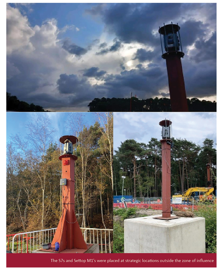
System selection
As a long term KOREC customer and Trimble user, Balfour Beatty engineers on this site are familiar with Trimble equipment and workflows. Consequently, four Trimble S7 Total Stations, renowned for both their high precision and reliability in all weather conditions were purchased, later supplemented with four additional S7s also hired from KOREC. When used in conjunction with Trimble 4D Control software (T4D) for automated movement detection and monitoring of infrastructure, these total stations became a straightforward to use and highly effective monitoring solution.
While the total stations were powered by an on-site generator, control was managed via the Settop M1 monitoring devices, enabling real-time remote monitoring and management. Acting as a field computer, remote switch, device server, router, Wi-Fi router, and 4G cellular modem all in one, the Settop M1s provided seamless remote access to the S7 total stations. This allowed Jack to check system status at any time, from anywhere, without the need for a complex IT setup, saving him a significant amount of time.
Set up
Under Jack’s guidance, the total stations and Settop M1s were positioned outside the zone of influence, away from the drill’s centre line. Mounted on pillars and protected by cages, the instruments were strategically located in accordance with the Geotechnical Design Report (GDR) provided by VEDA – specialists in trenchless installations working alongside Balfour Beatty on these crossings.
A four-week pre-monitoring phase was then conducted to gather sufficient baseline data, with the Trimble software configured to carry out automated monitoring rounds every hour, day and night.
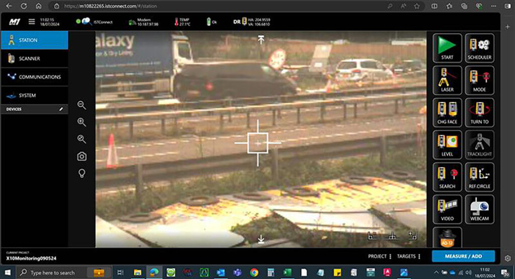
Live view of the carriageway from the Settop M1 WebUI
An alternative approach
While a few prisms were used for coordination before each round, the instruments mainly measured to the white centre line of the carriageway instead of fixed targets. This proved to be a highly effective use of DR measurement – especially on projects like this, where keeping traffic moving is key. By avoiding the need to constantly remove and reposition targets, disruption was kept to a minimum.
The Trimble S7s also come with VISION technology which provides live video streaming and high-resolution image capture, allowing Jack to see exactly what the instrument sees. This is essential for verifying measurements or checking for obstructions, movement, or tampering, without needing to physically access the site.
Using Trimble T4D software
Jack reports that even though he was relatively new to monitoring he found the Settop M1 WebUI and T4D software intuitive to use.
“If you want to check the level, just log on to the Settop box and hit the ‘check level’ button – it’s that simple and a real time saver – otherwise I’d have to go on site and physically stop and check each instrument. The same if you want to see where all the points are, just click the map, if you want graphs, click graphs. No need to dig around in settings and menus.”
Additionally, with a few helpful tips from the KOREC monitoring team, he was able to set up exactly the alert triggers he required using colour coded bands for the different tolerances with green indicating anything below the required 6mm of movement.
He was also able to program the system to ensure that no major triggers were alerted unless five points in the same area registered movement outside the specified tolerances. This was an important aspect of the set up because a misplaced traffic cone on the carriageway could cause multiple alarms.
Additionally, T4D would alert Jack if no data was collected over a period of hours, something that proved especially useful during a period of problems with the generator.
Stand out features of the system
For Jack, the priority on this project was clear: deliver accurate, reliable monitoring data without causing disruption to the utilities team. That meant the system had to provide clear, easy-to-understand reporting and Trimble’s T4D software delivered exactly that. Not only could it generate reports in the format required by National Highways, but it also made it easy to visualise key data, such as movement shown on a heat map.
One of the standout benefits for Jack was just how straightforward the system was to use and share with others. Training a colleague took no more than a single page of notes:
“The S7s, Settop M1’s and T4D were extremely easy to set up, especially because we are already used to Trimble equipment. I was easily able to summarise the operation into a single page document for another member of the team.”
Project completion
With the final crossing completed earlier this year, Jack reports that there were zero issues with the Trimble equipment, even when they had eight systems running simultaneously:
“The system has been so reliable and easy to use. If we did have any questions, then a quick call to KOREC has been answered immediately or returned within 10 minutes, KOREC has been brilliant!”
For further information on any of these products, please contact us here.
Download a formatted PDF of the case study here
How GeoDrone Survey helped a landowner pinpoint the exact proximity of an underground bunker to the Norfolk coastline thanks to Soarvo, a powerful cloud-based platform for managing and visualising geospatial data.
During the Second World War, many bunkers were built across England, often underground, to serve a range of purposes from coastal defence and civilian protection to housing early-warning radar systems. One such structure lies beneath a private garden on the Norfolk coast.
As a responsible landowner keen to look after his assets and align with local council planning updates, the property’s owner set out to answer a pressing question: “Where exactly does the bunker lie and how close is it to the eroding cliff edge?”
Fortunately, this wasn’t your average landowner. As the founder of Departure Lounge Media Group, a company specialising in videography, photography, 360° virtual tours, long-term timelapse solutions for construction and crucially, drone services, he was uniquely equipped to tackle the task.
Technologically savvy and well connected, he was able to draw on the expertise of two partners from previous projects:
FlyThru – specialists in manned and unmanned aerial data collection, FlyThru was responsible for all the survey work, above and below the ground. This included an underground survey of the bunker which had never been accurately mapped due to collapsed sections. To take on this demanding task, a confined-space drone, protected by a cage, was used to navigate the semi-blocked areas safely.
At ground level, a baseline survey was conducted to establish control points. 3D laser scans were also undertaken, with particular reference to the tunnel entrance, to help tie together the above and below ground data. Ground Control Points (GCPs) were also established for traditional photogrammetry and to ensure accuracy across the datasets.
GeoDrone – a company that offers a variety of solutions spanning the data acquisition, processing and analysis sectors backed up by expertise in processing data to extract information tailored to their clients’ requirements. On this project, GeoDrone would be responsible for combining the datasets in a way that would allow far more effective interpretation than the originally planned deliverable of a PDF.
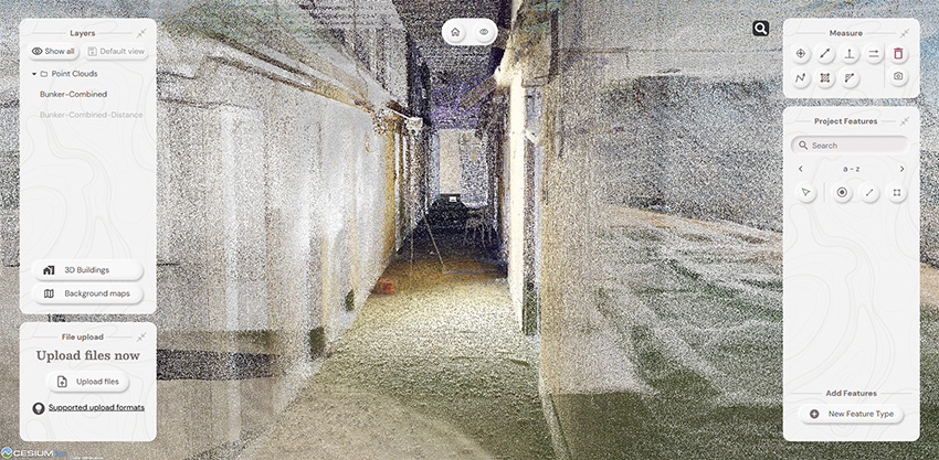
Point cloud data inside the bunker in Soarvo
Combining data sets and providing answers
For GeoDrone Director Jason Hagon, the challenge was to transform the various datasets into a clear, accessible deliverable – one that not only showcased the detailed survey work but also placed it in geographical context and addressed the landowner’s key concerns.
Importantly, Jason recognised that the value of the dense point cloud data lay not just in its quality, but in how easily it could be viewed and understood, particularly by third parties, without the need to invest in software licenses or costly hardware.
As a KOREC customer, Jason was already familiar with Soarvo, a platform developed by a KOREC sister company. Its tagline “Liberate your geospatial data” reflected exactly what he needed, a simple, cloud-based solution to visualise and share complex geospatial information without adding technical barriers.
Soarvo allows data from a range of sensors to be uploaded, processed, visualised, and shared in one platform and for this project, it was the clear choice. After receiving the processed data from FlyThru, Jason was able to upload it in minutes using a straightforward drag-and-drop procedure and begin work on it immediately thanks to the intuitive Soarvo interface.
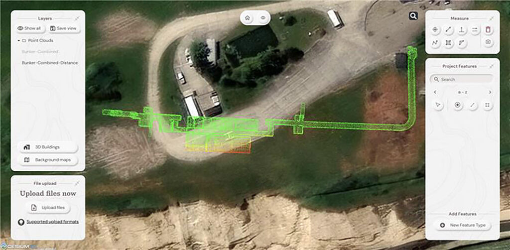
Bunker classified and colourised by distance to cliff in Soarvo
Soarvo benefits – what Jason rated on this project
Easy manipulation and sharing of high-density point cloud data – being able to load a very dense point cloud and have clients able to visualise it without any proprietary software or additional costly hardware, just a secure link via the cloud, is something that Jason feels is often overlooked but an ‘amazing’ benefit.
Integration of background maps for context – the ability to bring data into the real world and onto a background map of choice was key to this project with Jason selecting satellite imagery in this instance.
Fast loading, drawing and tiling – whether on a laptop, tablet or phone, Jason reports that the integration with the base map was extremely robust and fast with no stuttering or crashing, especially when zooming in and out.
Measurement tools – key to this project was the ability to show measurements including the bunker’s exact location in relation to the cliff along with the height of the cliff. Cross sections will also be used to add further detail and analysis.
Ease of use – Jason found the software very intuitive and required little additional support thanks to its simple layout.
Visualisation of the combined data sets – for the landowner, the ability to view the underground bunker in its entirety and in context, manipulate the dense point cloud data to take a closer look at the interior condition and above all take accurate measurements has been groundbreaking.
With the project now complete, Jason reports that the survey not only confirmed how close the bunker lies to the cliff edge, but also revealed inaccuracies in earlier surveys, which had misrepresented the bunker’s size and scale.
Reflecting on the process, Jason said: “It was a simple question to ask but potentially a complex one to answer. Soarvo made it easy to communicate detailed findings in a clear, accessible way – and it did the job extremely well.”
Further information:
Download a PDF of the case study here
Contact KOREC for a Soarvo demonstration now