

KOREC is delighted to announce that the Drone Pilot Academy, our training partners in the provision of flight training and Civil Aviation Authority (CAA) accredited pilot training courses, have successfully launched their Operational Safety Case consultancy service to assist KOREC senseFly eBee users attain EVLOS (Extended Visual Line of Sight) approval. A UK eBee user has already successfully attained this approval through the new Drone Pilot Academy service.
It will now be possible for the users of eBee X, eBee Plus and eBee Classic models in the UK and Northern Ireland to get approval to fly up to 1500m away from the remote pilot (compared to usual 500m) giving a potential operating range of 3km. This will bring a significant competitive advantage to KOREC customers, particularly those surveying quarries, coastal areas and large-scale projects by cutting extensively the need for multiple take-off and landing points.
eBee drone pilots applying for approval will need to submit an Operational Safety Case to the CAA and demonstrate a history of safe flying and an additional person to act as a spotter on site is required.
senseFly’s Christopher Thomson (Regional Manger EMEAI) said, “Seeing the eBee X being able to fulfil its true potential is hugely exciting. The UK is always on the forefront of pushing the advancements in UAV technology and the EVLOS permission across all of our platforms attests to this. This will now enable over 200 senseFly users to push the boundaries of their mapping capabilities”
Drone Pilot Academy’s Jim Ixer (Managing Director) said, “With the number of large scale mapping projects our clients are routinely involved with at the moment, and the number in the pipeline we wanted to offer a service that allows eBee operators to maximise the impressive flight endurance with the latest battery advancements. With a standard CAA permission, the limiting factor is the regulations, not the drone, so we sought to safely resolve that issue. Now we can offer a consultancy service that includes bespoke training to assist senseFly drone operators to attain the EVLOS accreditation from the CAA”
KOREC’s Richard Gauchwin (Business Area Manager – Mapping & GIS) said, “This really is a game changer for the UAV market in the UK. Being able to fly larger sites and now only requiring one take-off and landing point has huge benefits in terms of efficiencies the system can bring to businesses. The eBee X, with its flight time of up to 90 minutes, has always been capable of undertaking these larger surveys, but has been limited by the legislation governing maximum flight distance from the pilot; now it can realise its full potential.”
A PDF of the release can be downloaded here.

Jim Ixer, Managing Director of the Drone Pilot Academy with a senseFly eBee X
Combining high-quality performance, simple installation and easy operation.
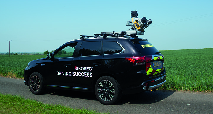
KOREC, Trimble’s leading distributor in the UK and Ireland, has taken delivery of Trimble’s ‘New Generation’ MX9 Mobile Mapping System.
The MX9 will be available to KOREC customers either through purchase or as KOREC’s preferred system for undertaking large-scale scanning and mapping surveys on behalf of its clients through its services company, Professional Services (KPS).
The Trimble MX9 is a complete field-to-finish mobile mapping solution and has been developed to deliver survey-grade data and detail in an easy to use and install design.
Performance
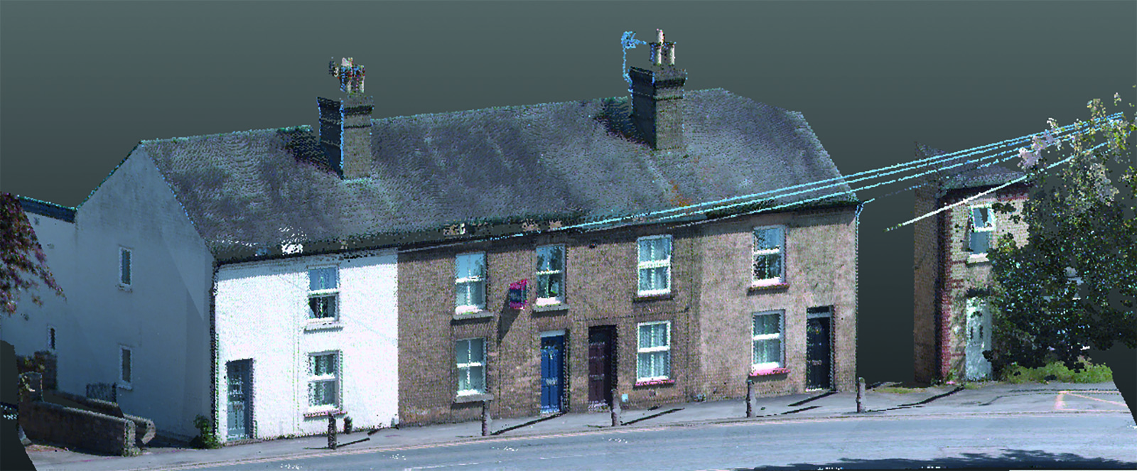
The MX9 combines a vehicle-mounted mobile lidar system, multi-camera imaging and field software for efficient, precise and high-volume data capture, delivering up to 500scans/second. The end result is data of unrivalled accuracy, density and repeatability.
Ease of Use
The system weighs just 37kg and can be easily mounted on a range of vehicles in less than 12 minutes. Operation is through intuitive browser-based field software, accessible via most tablets or any notebook.
As a Service
KOREC Professional Services means every company can offer their clients mobile mapping surveys without a large capital outlay and staff training. Specialising in tailor-made mapping surveys for a wide range of applications including topographic, engineering, and asset management surveys for whole city centres and boroughs or smaller projects, KPS combines expertise with the highest quality of mobile mapping data achievable.
Mark Reid, Professional Services Director said, “Our aim is to expand our customer’s business by offering clients mobile mapping surveys, and all their benefits, without the need for a hefty capital outlay or training costs. KOREC’s acquisition of the MX9 means that we are equipped to offer the very best in precise, high-volume data capture, faster than ever before.”
Alan Browne, KOREC CEO said, “As a company that has already invested heavily in mobile mapping systems, the purchase of a Trimble MX9 was an easy decision to make because simply it places KOREC and K-SERVICES customers, at the cutting edge of mobile mapping technology – the potential is tremendous.”
For a sample dataset or to discuss a Professional Services project, please contact Mark Reid, KOREC Professional Services Director on 07423628529 or by email at mark.reid@korecgroup.com
For sales enquiries, please contact your regional KOREC sales consultant.
ENDS
 KOREC is delighted to announce that it has signed an agreement with Swiss company, SenseFLY, to become the sole UK and Irish distributor of SenseFLY’s unmanned flying camera, the swinglet CAM.
The swinglet CAM is a lightweight, unmanned air vehicle (UAV) with a high resolution electronically integrated digital camera. Designed to undertake small scale aerial mapping projects it can be deployed in under one minute, is hand launched and has a take-off weight of just 500g. The camera records 10-40 cm/pixel images and can produce over 100 hectares of aerial photo coverage during its 30 minute flight.
An integrated GPS based miniature autopilot ensures that the swinglet CAM starts, flies and lands silently on its own. Its flight path is defined in easy to use PC based software and can be updated at any point during the flight by using the software’s simple drag and drop functions. When the swinglet CAM lands, images can be immediately downloaded and are ideal for use in a wide range of applications including wildlife monitoring, traffic monitoring, archaeology, crop monitoring, security, mapping or environmental projects.
KOREC’s Mapping Solutions Consultant Brock Ryder said, “The swinglet CAM has been developed to undertake a wide range of aerial mapping projects without the usual costs or set ups involved – it’s simply thrown in the air for take-off and returns to the same location for an automatic landing. Previous sales in Europe indicate that it will open up customised aerial photography to a whole new market in the UK and Ireland where previously costs were prohibitive – anyone from a small landowner to a large government body can expect a swift return on investment. End users can now be the pilot of their own aerial photography missions and have access to the data minutes after landing! Additionally, the swinglet CAM’s low weight and size mean that there are few flying restrictions*! It is the perfect addition to KOREC’s extensive portfolio of Trimble GPS and Mapping solutions.”
For further information please call KOREC on 0845 603 1214 (UK) or 01 456 4702 (Ireland) or view a video of the swinglet CAM in action on the KOREC website at http://bit.ly/korecswinglet
* Certain restrictions & permissions may be required for use of the UAV in Ireland & the UK. KOREC will provide guidance in the granting of permissions as required.
ENDS
About SenseFLY: Based in Switzerland, senseFly is an offshoot of the Laboratory of Intelligent Systems at EPFL – an organization at the cutting edge of research into collective aerial robotics, vision-based flight control for mini UAV and smart locomotion. www.sensefly.com