
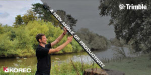
Trimble’s SiteVision is a geospatial tool created for today’s tech-savvy workforce.
Working in sync with your own mobile device, the unit utilises the very latest GNSS technology (including with the R12i – more on that to come) to pinpoint your design model down to cm accuracy.
This allows you to easily and accurately visualise your BIM design model in its true location, before a brick has been laid or concrete poured. What’s more, you can share that model, in real time, with your colleagues or with your client, wherever in the world they happen to be.
The solution is already in use across 1000’s of worksites globally, including here in both the UK & Ireland. Customers here include Gareth Price of O’Brien Contractors in the West Midlands, and the A14 Integrated Delivery Team (a JV of Costain, Skanska, Balfour Beatty & Atkins Jacobs) headed up by Mark Lawton – check out Mark’s thoughts on the device in the video below.
You can also read about the experience of O’Brien’s as they utilised the kit on a new stretch of light railway in our customer story.
The versatile and multi-featured tool lends itself to many industries including, to name a few; civil construction & inspection, building construction, utilities, urban transportation & planning, architecture & residential development, and more.
We’ve picked our Top 8 features of this extraordinary device, to show just how powerful and useful it is;
- Simple, intuitive operation with your smartphone
- Built-in data visualisation & modelling
- Clear & Simple Communication with Trimble Connect
- cm-accuracy thanks to GNSS integration – including the new R12i
- Safely measure distances in hazardous spots with EDM
- Easy & fast data reporting – notes, photos & assign tasks
- Always On – load your model even in internet blackspots
- Compatible with huge range of platforms & data formats
To see SiteVision for yourself, why not get in touch and arrange a demo with our friendly team? Contact Us
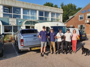
The Benchmark Surveys team; Josh Rogers, Sebastian Glover, James Richards, Sebastian Richards, Helen Richards & Dennis the dog
It’s been just 3 weeks since the R12i was launched to the world on 1st September.
But already Benchmark Surveys of Exeter have taken delivery of their new GNSS solution – the very first to be sold in the UK.
The team took part in trials with the new unit at the end of August, and it’s fair to say, they were blown away by the results they saw – watch the video below to see what we mean!
To see the R12i for yourself, take a look on the product page and sign yourself up for a demo;
Or find out more about Benchmark’s work;
https://www.benchmarksurveys.co.uk/
This week saw the launch of the next level GNSS solution from Trimble – the R12i.
Featuring robust IMU tilt-compensation via their patented TIP (Trimble Inertial Platform) technology, you can forget about levelling the pole and focus on collecting points, faster, safer and easier.
Utilising an angled pole allows you to obtain previously impossible or hazardous points – such as corners of buildings, tree bases and by rivers/watercourses.
With no time wasted calibrating or levelling, you can be much more rapid when collecting points – check out the video here to see how the R12i compares!
We are hosting a special R12i webinar on the 10th, to give you the complete lowdown on the new features, the benefits to your business, and multiple applications. Sign yourself up;
Join our launch webinar on the 10th

Great Scott!
KOREC Mapping Consultants Brock Ryder and Andrew Blogg have definitely launched something into the sky – but what is it?!
Keep watching our front page news section for an exciting announcement on the latest addition to the KOREC mapping portfolio.
![]() KOREC is delighted to announce that it has signed an agreement with Swiss company, SenseFLY, to become the sole UK and Irish distributor of SenseFLY’s unmanned flying camera, the swinglet CAM.
KOREC is delighted to announce that it has signed an agreement with Swiss company, SenseFLY, to become the sole UK and Irish distributor of SenseFLY’s unmanned flying camera, the swinglet CAM.
The swinglet CAM is a lightweight, unmanned air vehicle (UAV) with a high resolution electronically integrated digital camera. Designed to undertake small scale aerial mapping projects it can be deployed in under one minute, is hand launched and has a take-off weight of just 500g. The camera records 10-40 cm/pixel images and can produce over 100 hectares of aerial photo coverage during its 30 minute flight.
An integrated GPS based miniature autopilot ensures that the swinglet CAM starts, flies and lands silently on its own. Its flight path is defined in easy to use PC based software and can be updated at any point during the flight by using the software’s simple drag and drop functions. When the swinglet CAM lands, images can be immediately downloaded and are ideal for use in a wide range of applications including wildlife monitoring, traffic monitoring, archaeology, crop monitoring, security, mapping or environmental projects.
KOREC’s Mapping Solutions Consultant Brock Ryder said, “The swinglet CAM has been developed to undertake a wide range of aerial mapping projects without the usual costs or set ups involved – it’s simply thrown in the air for take-off and returns to the same location for an automatic landing. Previous sales in Europe indicate that it will open up customised aerial photography to a whole new market in the UK and Ireland where previously costs were prohibitive – anyone from a small landowner to a large government body can expect a swift return on investment. End users can now be the pilot of their own aerial photography missions and have access to the data minutes after landing! Additionally, the swinglet CAM’s low weight and size mean that there are few flying restrictions*! It is the perfect addition to KOREC’s extensive portfolio of Trimble GPS and Mapping solutions.”
For further information please call KOREC on 0845 603 1214 (UK) or 01 456 4702 (Ireland) or view a video of the swinglet CAM in action on the KOREC website at http://bit.ly/korecswinglet
* Certain restrictions & permissions may be required for use of the UAV in Ireland & the UK. KOREC will provide guidance in the granting of permissions as required.
ENDS
About SenseFLY: Based in Switzerland, senseFly is an offshoot of the Laboratory of Intelligent Systems at EPFL – an organization at the cutting edge of research into collective aerial robotics, vision-based flight control for mini UAV and smart locomotion. www.sensefly.com
 KOREC is delighted to announce that it has signed an agreement to become an Intelligent Trench* partner and a UK supplier of the Intelligent Trench underground mapping solution which will allow every road excavation in the UK to be recorded, photographed and mapped on a national database.
The solution has been developed specifically for use by Utilities, Contractors and Local Authorities. It comprises a Trimble Nomad GPS handheld with U-Track software, a 3MTM DynatelTM Locator, 3M RFID (Radio Frequency Identification) markers with passive RFID tag technology, and a national database with web based access.
The solution works two ways:
Contractors and Utilities can capture and record data on a new excavation for future reference by using the Trimble Nomad handheld to record the GPS coordinates of the marker positions and capture photographs and asset data in a format prescribed by the National Underground Asset Group (NUAG) including attributes such as the material and diameter of the pipe. Once collected, the U-Track software will automatically upload these records to the Exor managed Intelligent Trench database, either via GPRS or subsequent ActiveSync connection on an internet connected PC. Surveys can be similarly uploaded and shared for future reference.
Contractors and Utilities can view existing information remotely via the web portal to see what information already exists, or at the location itself in order to safely plan works, carry out carefully targeted digs and avoid 3rd party damage. The DynatelTM locator enables users to home in accurately on the actual location of an existing marker which enables the U-Track software running on the Trimble Nomad to access the records, in the field, from the Exor Intelligent Trench database, reproducing the same photographs that were taken before the excavation was reinstated.
KOREC’s Mapping Consultant Martyn Palmer said, “The Trimble Nomad is the perfect GPS handheld for this solution. Rugged, with 2 to 5 metre real-time accuracy, it also offers a 5 megapixel digital camera with integrated flash, wireless internet connectivity, a barcode scanner (so that each marker can be scanned and given a unique ID) and an RS-232 compatible port for connection to the Dynatel locator. The benefits that this Intelligent Trench solution can offer Utilites, Contractors and Local Authorities are numerous – fewer unnecessary exploratory or ‘dry’ excavations, traceability of all works undertaken, reduced damage to underground assets, a reduction in traffic congestion and of course improved safety for site workers. Collection of data is straightforward, requiring no specialist skills, and subsequent access to the Exor Intelligent Trench database is free for all registered users.”
The Intelligent Trench solution is available now from KOREC and was recently shortlisted in the UK for awards by the National Joint Utilities Group (NJUG) and the Water Industry Achievement Awards (WIAA).
For further information on the Intelligent Trench underground mapping solution, please call KOREC on 0845 603 1214
*3M, Exor, Infotec and Trac-ID have joined forces to offer a solution called Intelligent Trench

CAT D7E & Trimble on the KOREC stand
Hillhead 2010 has just finished and this years glorious weather was appreciated by visitors and exhibitors alike.
Aided by Trimble and Finning, the KOREC stand was busy for the duration with the full Trimble range of Machine Control and Site Positioning Systems on show, all backed up by KOREC’s expertise.
As predicted, the Finning supplied Caterpillar D7E with Trimble’s GCS900 system, attracted lots of attention. KOREC’s Peter Brooks explains, “We asked Finning if they could help us out at this years show by providing a Caterpillar D7E for our stand. This machine – the first-ever electric drive track-type tractor D7E consuming up to 20 percent less fuel while increasing the productivity by 10 percent – reflects just what the business is all about, innovation and technology and ultimately sustainability.”
There was also a huge amount of interest in the Trimble Site Positioning Systems demonstrated the stand. Contractors were keen to learn how the SPS products can utilise GPS or Robotic Total Stations to help them improve their efficiency on site with the use of the Trimble SCS900 Site Controller Software.
To find out more about the CAT D7E and ‘Lastability’ please visit the Finning site