Balancing peace and precision
Using Trimble Catalyst to accurately map plots on their natural burial ground, Forget Me Not Fields has found a perfect balance between efficiency and tranquillity amongst the wildflower meadows. Download […]


Using Trimble Catalyst to accurately map plots on their natural burial ground, Forget Me Not Fields has found a perfect balance between efficiency and tranquillity amongst the wildflower meadows. Download […]
Download a formatted PDF of the story here
In recent years, more people have been turning away from conventional burial practices and choosing alternatives that better align with their personal beliefs, attitudes toward death, and overall philosophy. This shift has driven a steady rise in demand for environmentally friendly options, particularly natural burial, as people seek to spend more time in nature when remembering loved ones.
Established in 2022, Forget Me Not Fields is one of these sites located on the Church Farm Estate in Wirral. A family run business for over thirty years, Church Farm is a perfect location for those seeking a natural burial based on its beautiful location overlooking the River Dee Estuary towards North Wales and has the benefit of already being well regarded by the local community through its award-winning family farm park attraction,
The idea of creating a burial ground emerged when the Ledsham family explored options following the loss of relatives. They realised that a natural burial ground could offer both environmental benefits and a more positive experience for those grieving.
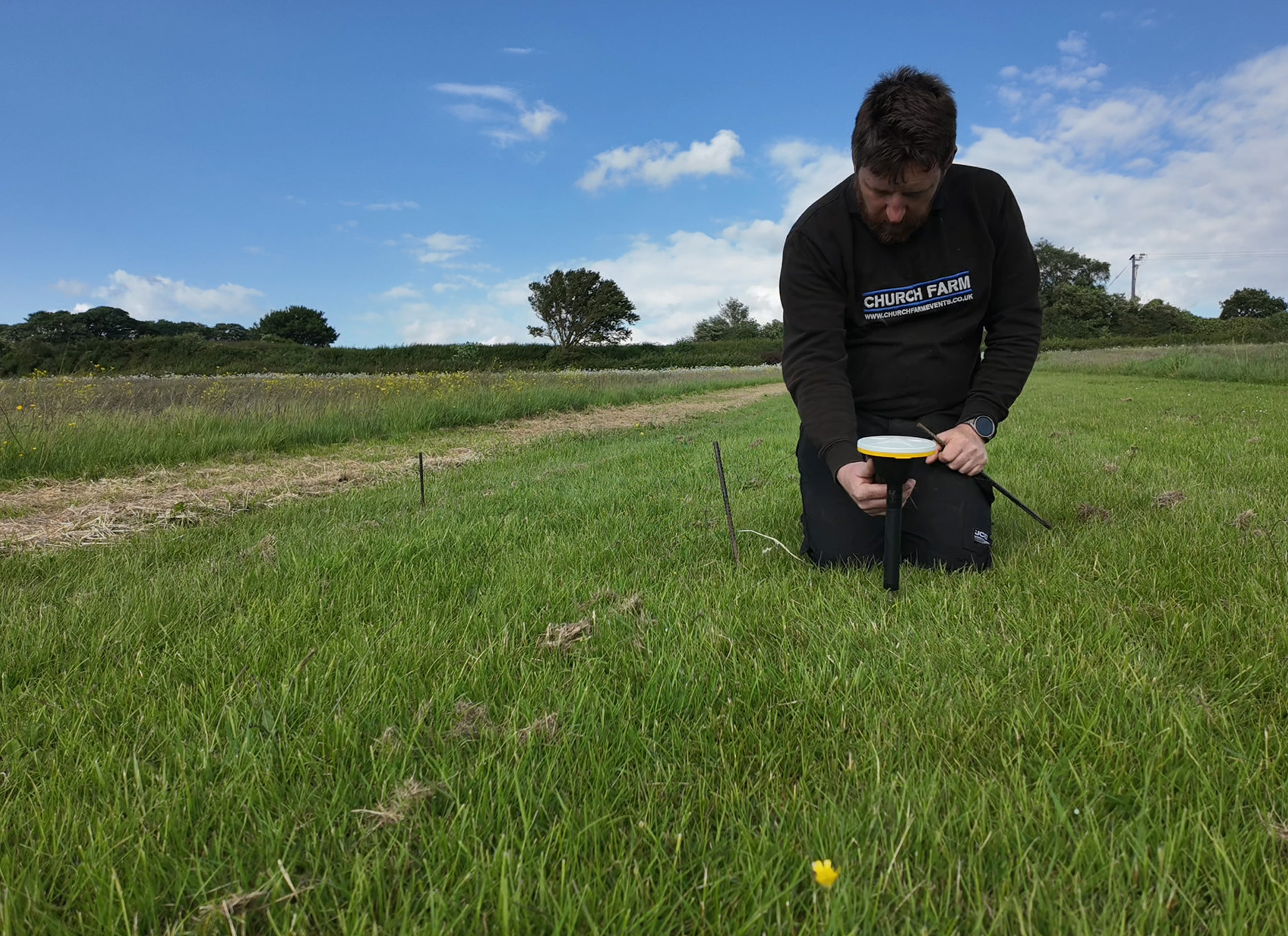
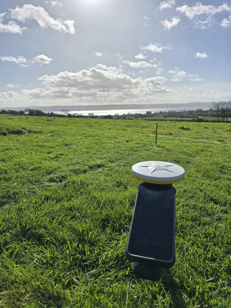
Whilst a hands-on family concern, it is Director Matthew Ledsham who is responsible for the technical side of the business including the website, mapping, documentation and database. Whilst providing a warm and tranquil experience for those who visit is a priority, behind the scenes, it is the careful planning and use of centimetre mapping technology that keeps the site organised and running smoothly.
The 21-acre site consists of three former horse-grazing fields, beautiful open land, but with few distinguishing features beyond the boundary hedgerows making it difficult to get useful bearings. For Matthew, the challenge therefore lay in establishing a precise grid of 1.5 m × 1.5 m plots for ashes interments, and later larger burial sites, across this expanse. Whilst creating a map of the overall area proved relatively straightforward using Autodesk Civil 3D design software, locating an exact plot in the middle of such a large field remained problematic. He felt that the triangulation method commonly used at smaller sites would be impractical here and likely to require external expertise which he did not want to have to rely on.
Matthew then heard about Trimble Catalyst, a low-cost, high accuracy GNSS solution, through his AutoCAD contact. A visit to the KOREC Catalyst web shop supplied all the information he needed and he was able to easily select a suitable package comprising a low-cost DA2 GNSS receiver, a centimetre subscription based on hours of use and Soarvo Mobile software to run on his smartphone for collecting and viewing the map information.
Matthew selected the centimetre accuracy to ensure that he could maximise the number of plots by accurately being able to mark out burial sites with a sufficient buffer zone around them whilst keeping the site tranquil and organised.
“We knew Catalyst was the system we were looking for. This is a small family business where we wear many hats and therefore our days are carefully planned. I didn’t need centimetre-accurate positions all the time because I’d plan the mapping work in the fields every two weeks or so, over a couple of hours. The subscription package based on hourly usage was therefore great value.”
Ease of use – Matthew has no previous survey and mapping experience
Accuracy – centimetre accuracy without having to pay for or set up a base station
Flexible subscription – extremely cost-effective for a system used for two hours every couple of weeks.
KOREC support – reliable with a high level of friendly assistance
Initially Matthew used the Catalyst system on a pole, known as the ‘magic stick’ for its problem solving functionality, but finding himself often kneeling on the ground to mark out plots, switched instead to using the system on a special short handle for ease of use and portability across the large site.
Adept at using technology, Matthew found the system easy to set up and use with a little assistance from KOREC’s technical support:
“There was definitely a learning curve because I’m not a surveyor and had no experience with this type of technology, but KOREC support talked me through any queries. Now we have a simple workflow in place for easily taking our maps out of Autodesk Civil 3D and prepared for use in the field on the Soarvo Mobile software with Catalyst. It’s second nature and couldn’t be easier!”
Now an experienced user of the system, Matthew is finding new applications for it as they continue to work on the burial ground, mapping additional wildflower planting, new laybys etc.
He understands that for those considering Forget Me Not Fields, the experience is a very visual one with the views contributing to the tranquillity of the experience. He’s therefore looking at integrating his Trimble Catalyst solution with Trimble SiteVision, an advanced Augmented Reality (AR) system designed for visualising geospatial data in real-world environments. This would enable him to allow visitors to see the view from certain plot positions via information sent by email if they are unable to visit the site in person.
He concludes:
“If I had to highlight one standout benefit of the system, aside from the customer service from KOREC, it would be its ease of use. Once you’re up to speed, it takes me less than an hour to assign a task, navigate to the plot and begin work. This maximises my time in the field, which is crucial when we’re such a small but busy team.”
For further information on Trimble Catalyst, please contact us here.