In his last column, KOREC’s Mark Poveda delved into the crucial questions to consider before buying a 3D Laser Scanner. In this column, he turns his focus to four important factors to weigh up before making an investment in a GNSS survey-grade receiver.
Benchmark Surveys and the Trimble R12i
Across the geospatial industry, we’re seeing a bigger shift towards people using GNSS for their survey grade data collection and setting out operations, thanks in part to developments that have increased their ability to work accurately in challenging GNSS conditions such as urban canyons or under tree canopy. However, it’s important to state that if it’s high-accuracy, mm positions you’re after, then a total station will always be your go to.
In this column, I’m going to take a look at four GNSS areas it’s worth considering, especially if you’re keen to avoid time consuming total station set ups in your day-to-day survey work.
1. It’s not about the number of channels, it’s about how your receiver handles and decodes them
When choosing the correct receiver for your purposes, it’s important to understand that most of them now support multi-constellations (GPS, GLONASS, Galileo, BeiDou), but it’s also important to check that they also support L1, L2 and L5 frequencies which mitigate signal interference in harsh GNSS environments. For example, Trimble’s ProPoint technology, found in several of their receivers, takes signals from all available constellations via three frequencies and uses dual core receivers for fast and accurate precision in challenging survey scenarios. My advice here would be to test repeatability of positions in these conditions during a field trial. We don’t want the spoofed accuracies that can occur with some receivers and this is the only way to ensure that doesn’t happen.
2. RTK and Correction Services for positioning security – choose wisely, they’re not all the same
Your RTK and Correction Services are key to continuous centimetre positions in the field and especially if you’re likely to be working where there’s patchy mobile coverage or your signal may drop in areas like quarries. If you want to avoid getting the total station out for those few points you need when there’s no signal, then it’s important to check that your receivers can also ‘bridge the gap’ using satellite corrections. KOREC customers report that the xFill function on their Trimble receivers, which does exactly this, saves them around 30 minutes of site time by avoiding a total station set up, it all adds up on downtime cost savings. Sometimes they’re not even aware the feature has kicked in because work is continuous and uninterrupted. Again, something to check on your field test.
3. Environmental durability and endurance – will your expensive investment survive the conditions you work in?
Construction sites are demanding places to work in and on top of that, did you know that last year rain fell on 171 days in the UK!
If your expensive investment is going to handle the British weather as well as tough site conditions, then you’ll need an IP65 rating for your receiver, or if you want it to withstand submersion, then IP68, plus you’ll need MIL-STD810G or H for ruggedness for both your receiver and controller. Especially, take a really good look at the build quality during your field test and check out whether it comes with local servicing and repairs from your GNSS supplier.
4. It’s all about the workflow – protecting your data and turning it into manageable information
Finally, a successful survey isn’t just about the receiver, it’s about collecting, processing and analysing that data and of course, protecting the information you’ve collected. Unfortunately instrument theft is a common occurrence so we definitely recommend that your receiver has the ability to sync with secure cloud storage and also that you can choose where it is hosted rather than it ending up in a random location anywhere in the world.
It’s also important to consider the end-to-end workflow and ensure that yours is futureproof. For example, is your collected information compatible with your back-end packages if you’re an n4ce or SCC user? Seamless integration is vital for saving office time on the processing and decoding of your collected data.
Whilst I hope this information is a good guide to what to look for in a GNSS Receiver, my best advice would be to rigorously check before you buy with an extensive field test and especially, check its accuracy and repeatability in different conditions.
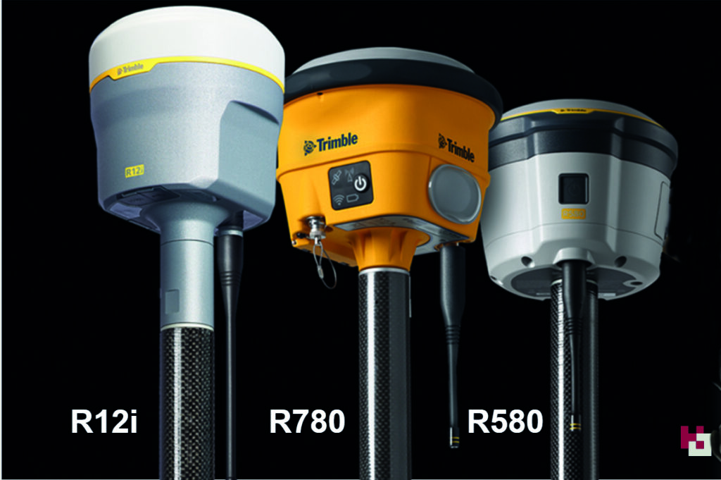
How to choose the right Trimble GNSS for your survey applications – a quick guide to our three best-selling receivers, the R12i, R780 and R580
Choosing the right Trimble GNSS receiver depends on several factors, including your specific application, accuracy requirements, environmental conditions, and budget. Here are some key considerations to help you make an informed decision:
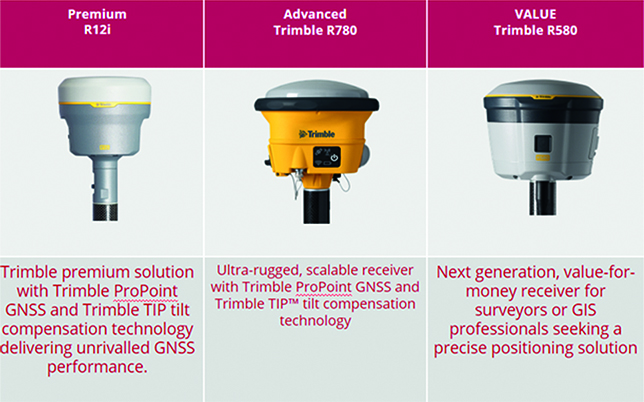
Common factors to the R12i (Premium), R780 (Rugged) and R580 (Value)
- When you buy into the Trimble brand and KOREC support, it’s immaterial which receiver you choose. All of them are based on Trimble’s 40-year heritage dedicated to reliability and innovation and they are all backed up by KOREC’s renowned technical support, training and T.R.U.S.T ethos. You’re buying into a premium brand and that brings a host of proven benefits including long term value, extensive R&D and high-level customer support .
- Trimble users have a single source of supply for the complete GNSS workflow – VRS Network, Mobile SIM cards, GNSS hardware, controllers, field software and augmentation services like xFill – just call KOREC.
- They all have Trimble ProPoint technology, Trimble’s trade-marked technology for increased performance in challenging GNSS environments, including close proximity to trees and in urban environments.
- The all have Trimble Access software compatibility and the same choice of field data loggers to run that software on.
- They all offer survey grade accuracy
- They are all compatible with Trimble Connect for easy transfer of field data back to the office and seamless integration with third party software packages such as n4CE and SCC and others.
- They are all compatible with Trimble Positioning Services like Trimble RTX, xFill, xFill unlimited and VRS Now. (See below for more details on each service)
- They all have Trimble made and supported rugged state-of-the-art field controllers in both current Windows OS and Android versions.
So what’s different?
In a nutshell:
The Trimble R12i is a premium survey GNSS offering dual Maxwell 7 Gen chip, fully loaded with all constellations, and can be used as a base and rover. Features include TiP technology (Trimble Inertial Positioning), ProPoint and xFill limited. It’s the best-in-class GNSS receiver with tilt technology and all of these features are offered as part of the standard package.
The Trimble R780 is a scalable survey GNSS offering ProPoint, a single Maxwell 7 Gen chip and is upgradeable to enable Tilt and full constellations. It can be used in base and rover modeAdditionally it has an ultra-strong housing and an increased IP spec. . This is the perfect receiver to grow with your business.
The Trimble R580 will provide the best return on investment and an affordable way to buy into the Trimble brand. It’s enabled with all constellations, ProPoint technology, and xFill Limited. However, it does not include TiP technology and is not upgradable.
FAQ’s
Which of these Trimble GNSS receiver models offer tilt compensation technology?
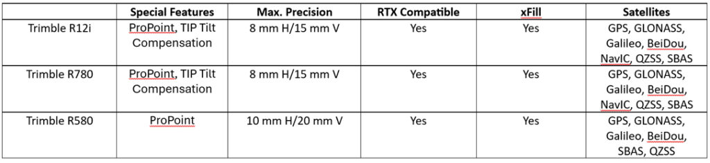
The Trimble R12i and Trimble R780 both offer Trimble Inertial Platform (TIP) IMU-based tilt compensation technology.
Which Trimble GNSS receiver models offer Trimble ProPoint GNSS technology?
The Trimble R12i, Trimble R780, and Trimble R580 GNSS receivers all come with Trimble ProPoint technology for increased performance in challenging GNSS environments, including close proximity to trees and in urban environments.
Which Trimble GNSS receiver models support Trimble RTX corrections?
All three models support Trimble RTX corrections, both via L-band (satellite) broadcast and over the internet.
RTX is a streaming service for corrections, managed by Trimble, which provides a correction service using a geostationary satellite – it does not require an internet connection.
On the RTX streaming service there are two products that our GNSS portfolio can use, xFill and xFill unlimited.
What is Trimble xFill limited
All three receivers offer Trimble xFill Limited as standard. This feature enables cm-levels corrections whenever the internet connection goes down for up to 5-10 minutes allowing surveyors to carry on working.
What is Trimble xFill unlimited
This feature enables the GNSS to carry on working with satellite corrections, without internet, for an unlimited amount of time. However, the user needs to be connected first to a VRS network for this to work. Ask us about our current special offer on xFill unlimited.
What is Trimble VRS Now Trimble VRS Now is a network of Continuously Operating Reference Stations (CORS), which provides users with cm-level corrections for their GNSS instruments, via the Internet. This enables users to work to cm-level anywhere there is a VRS network and a mobile internet signal. Trimble has additional permanent reference stations across the UK to strengthen the overall RTK solution, augmenting the network – increased accuracy and availability.
Q: What is the standout feature of the Trimble R12i for your company?
A: “It always works”
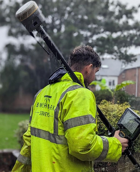
Benchmark Surveys was the first company in the UK to invest in a Trimble R12i GNSS and its continuing commitment to the technology is based on Trimble’s 40-year legacy of reliability and innovation
Download a PDF of the story here
It’s been 40 years since Trimble launched its first GPS onto the market and since then we’ve seen over 30 different iterations culminating in the arrival of the R12i in 2022.
The most advanced survey grade GNSS available, the Trimble R12i underlines Trimble’s commitment to development with its unique combination of technologies delivering a 30% productivity improvement on standard GNSS.
The adoption of this receiver by Exeter based Benchmark Surveys, the first company to purchase one in the UK, has not only transformed the way the company’s surveyors work but has also significantly enhanced the quality and quantity of data they provide to clients.
Transformative system “makes surveying pleasurable”
Benchmark Surveys’ Survey Manager, James Richards, one of xyHt’s esteemed 23 Young Geospatial Professionals to Watch in 2023, is appreciative of all the technologies offered by the Trimble R12i, but rightly points out that the single most important factor for productivity in the field is that that your GNSS always works!
He reports that everyone on the Benchmark team appreciates the R12i simply because it’s always reliable, always works and there’s never been a hardware issue – important benefits that work hand in hand with its performance:
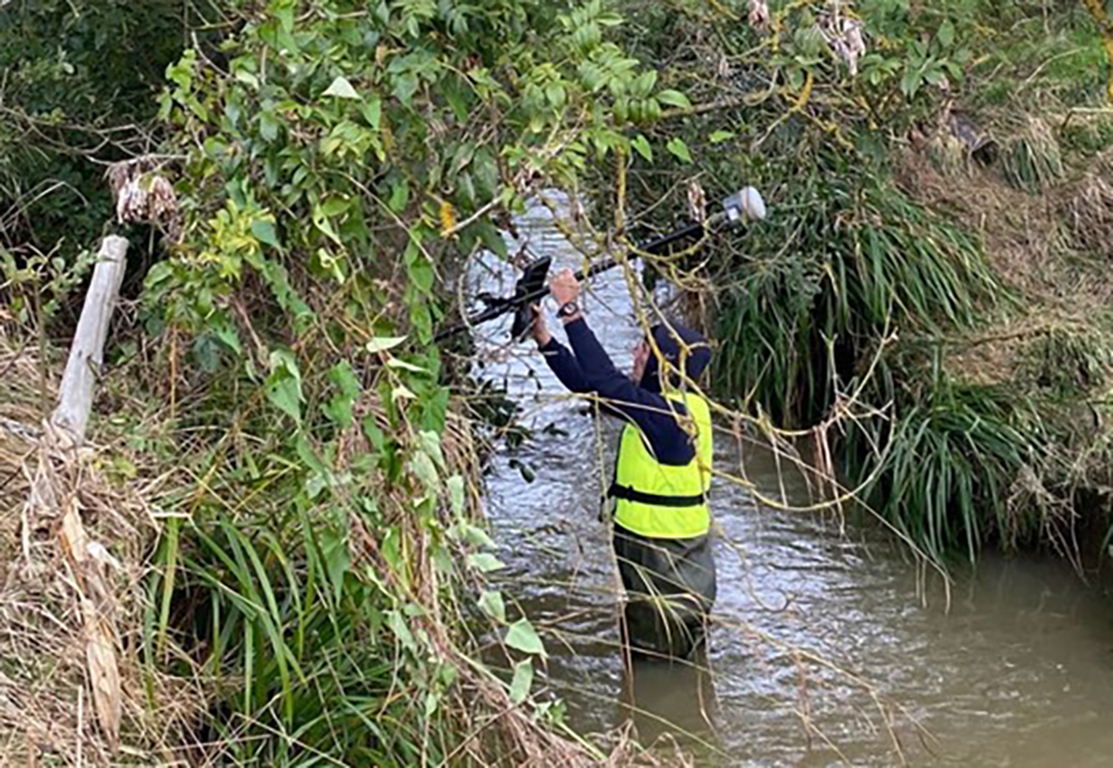
“The R12i’s capabilities shine, even in challenging surveying environments with difficult terrains such as banks, ditches, and areas with overhanging canopies – these are scenarios that surveyors come up against regularly and an area where the R12i decidedly ups productivity. Traditional equipment might falter in such conditions, but Trimble’s TIP (insert link to piece on the IMU) and ProPoint technologies ensure that Benchmark surveyors can effectively capture these challenging data points, leading to fewer client requests for additional information.”
What was once a time-consuming task has become fast and easy and even “pleasurable”, adding to the overall satisfaction of the Benchmark team who can effectively capture points in vegetation and under canopy where other GNSS would struggle.
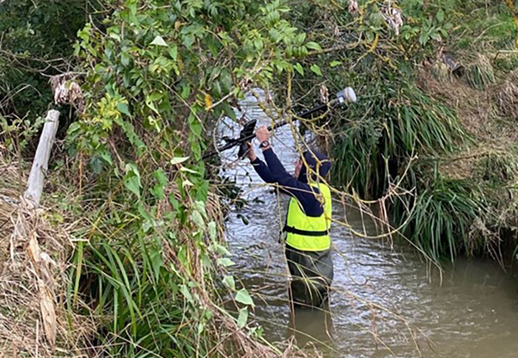
Instagram follower comment on post: Tilt works well under heavy canopy?
Benchmark Surveys: Yes it does 👍
In particular, James emphasises the strong business case for investing in the R12i GNSS over any other system. The decision to adopt Trimble’s technology is not merely based on brand loyalty but on the functionality and reliability that the team relies on to deliver the highest quality data to clients.
Trimble’s commitment to innovation, backed up by KOREC’s support, training and T.R.U.S.T ethos aligns seamlessly with Benchmark’s dedication to providing top-notch surveying services.