“Surveying isn’t just about surveyors, right?… it’s about the power of spatial understanding for everyone.”
That’s what Barry Bassnet published on LinkedIn recently – and let’s just say his post sparked more interest than a KOREC consultant arriving on site with a bag of warm doughnuts! And why did he make this comment? Because he’d just seen a demonstration of Soarvo, a new cloud-based platform that reimagines how 3D spatial data should look, feel and function for a much broader audience, one that’s well beyond the usual circle of geospatial professionals.
Barry suggested that we’ve become so laser-focused on CAD deliverables that we risk reducing rich, multi-dimensional data into flat lines on a page. Accurate lines, for sure -but certainly less accessible to the many people who could actually benefit from the data; a list that includes project managers, planners, environmental consultants, utility specialists and even the general public. These are the typical stakeholders who need to understand space and context so why not give them a format that makes sense, and why not ensure that the software that provides this information is truly visual with a user interface so intuitive that nobody needs expensive training on how to use it?
…and the solution is Soarvo
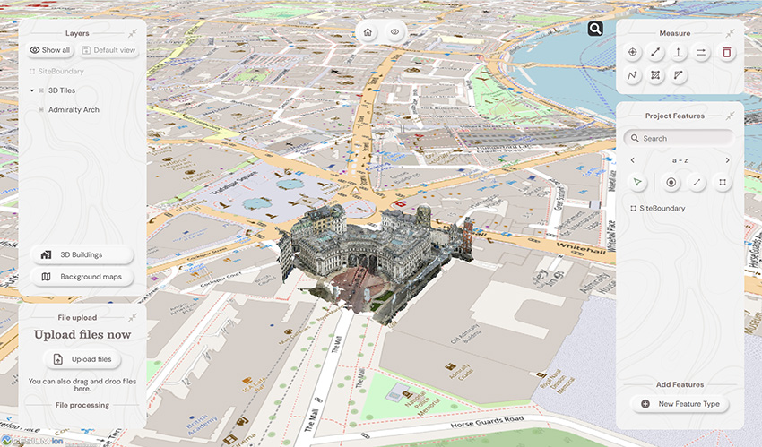
Here at KOREC we have the means for our customers to do exactly that thanks to Soarvo. Humans are visual creatures (we process visuals 60,000 times faster than text) and Soarvo taps into that by presenting survey data from any number of different sensors in an intuitive, interactive 3D environment that even the non-technical can navigate with ease. Remember how Google Earth revolutionised map navigation…that’s what Soarvo can do for survey data.
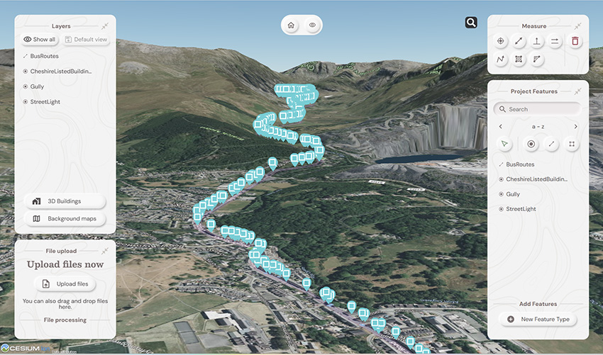
We’ve already talked about Soarvo functionality in an earlier blog ‘Born of Frustration’, and how it can unlock the full value of geospatial data but today we’re not here to talk about some hypothetical use case, it’s time to show the results from real world projects and where better to start than with a Soarvo highlight – the drone workflow.
We therefore despatched our KOREC drone specialist to undertake two drone focused projects that would not only showcase Soarvo’s data handling and processing but also the Wingtra Gen II drone with VTOL:
Drone project 1: Into the woods
Our first mission? A dense forest survey to assess tree density and map the terrain for flood risk analysis. For this, the Wingtra Gen II, fitted with a LiDAR sensor, was the obvious choice thanks to its ability to penetrate through thick canopy and deliver multiple returns.
Once complete, the LiDAR was swiftly swapped out for Wingtra’s premium RGB61 camera and the site was re-flown at 100 metres (up from 80m). Same flight plan, fresh perspective.
Processing the Data
Data was processed in the Wingtra LiDAR app, then seamlessly uploaded into Soarvo – a simple drag and drop – and instantly ready to be explored, analysed, and shared with a far wider audience, all with zero fuss.
Soarvo standouts on this project
- See the forest and the ground: The Wingtra Gen II with LiDAR cuts through the forest’s canopy to ground level. Once in Soarvo, the point cloud can be colourised by height and then a clipping plane used to show data just at ground level for better assessing flood risk.

Point cloud colourised by height
- Focus only on what you need: Soarvo has the ability to read point cloud classifications and remove the ones not relevant to your application from view. In this case we created a purely ground level view to analyse the natural drainage within the forest and to examine where the ditches converge and assess what is happening in these vulnerable areas.
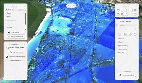
Showing the natural drainage within the forest
- RGB data rendered in seconds: With the RGB61 sensor data, we produced an ultra-accurate 3D model of the forest that loads and renders impressively fast. Bonus: Soarvo allows you to drape the orthomosaic over the terrain, offering a rich, contextualised visual that’s miles ahead of a flat 2D map.
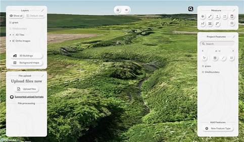
Orthomosaic draped over the terrain
- Snapshots with measurements: The ‘Snapshot’ tool came in handy for exporting JPEGs with embedded measurements. This function is ideal for briefing teams and stakeholders – no confusion, just clear visuals with context.
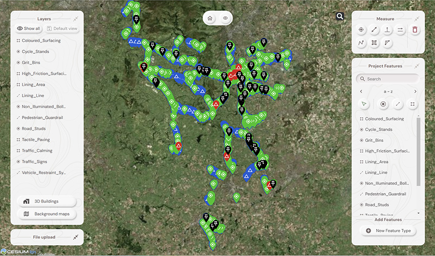
- Buit in GIS – done properly: Unlike most platforms, Soarvo includes full GIS functionality. Create features, draw polygons, and record detailed attribute data – not just vague notes. A great time saver, everything in one place, exactly where you need it.
Permission to fly the forest kindly granted by Phillip Wilcox-Moore, Managing Director, Axter Ltd. We’ll be covering this community story in an upcoming case study.
Drone Project 2: No stone unmeasured
Next up, a quarry stockpile survey. This time, it was all about volume calculations with a single flight using the RGB61 sensor. Just 7 minutes and 152 images later, the job was done.
Processing the drone data:
This data was processed in Soarvo by simply uploading the raw images in a zip file. Once loaded, Soarvo takes care of the rest generating an orthomosaic, 3D mesh and point cloud. No third-party software required, no CAD skills required and all processed and ready for sharing in typically, under an hour.
Soarvo standouts on this project
- Calculate volumes, fast! Let’s start with the main aim of this project, volume calculations – a regular need in quarry operations because that’s where the value lies. With Soarvo, it’s refreshingly easy, simply draw a polygon around the stockpile base, hit ‘calculate volume’, and you’re done. As accurate as traditional GPS-based surveys only faster, easier, safer and with the option for putting down more points for even higher accuracy, all completed from the desk.
- Context matters: Unlike many platforms, Soarvo shows your drone generated point cloud in full context – no black voids, just clean, continuous terrain on a choice of background mapping that adds the sort of extra context you need for a true real-world view, ideal for planning access, security etc.
- More ways for easy visualisation: Simply use the ‘snapshot’ function with added notes or measurements for easy insights without any technical expertise required.

Quarry point cloud shown in context to surroundings – no black void!
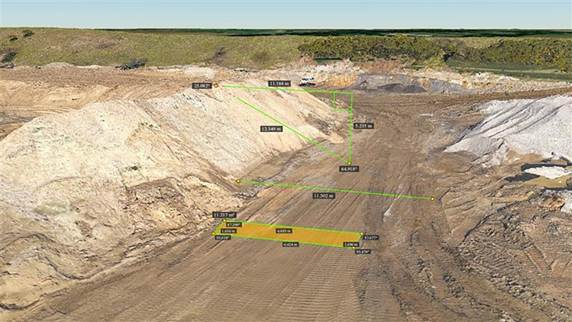
‘Snapshot’ with measurements
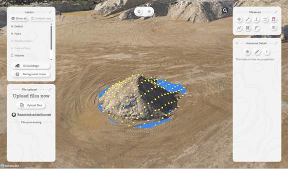
Calculating stockpile volumes – add as many points as you wish

Volume calculation report
And general to both projects – four more Soarvo benefits
No limits on the number of people who have access to the data
It’s all about making spatial data more accessible to more stakeholders – securely and without limits. Anyone you grant access can view the data straight from a web browser, no installs, no restrictions.
Security is vital, so it’s named user access only
Importantly, by avoiding use of a hyperlink, security is increased and Soarvo users can share this data only through named user access. Data security has been a key building block in the development of Soarvo since its conception.
Unique to Soarvo – merge and view ALL your data in one place
With Soarvo, you can bring together all your datasets – regardless of sensor type – into a single, cohesive view. But it doesn’t stop there. You can create layers of other key information too, like CAD-based topo surveys, GIS data with feature and attribute details (eg, boreholes), or even supporting documents like drainage reports. Just click to open with no digging around. It’s a genuinely useful feature, and a unique one that sets Soarvo apart.
Add context to your data – no black voids here
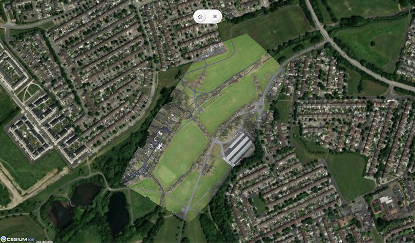
Soarvo provides context around your dataset and positions it in the real world rather than a giant black void. For example, your laser scan point cloud doesn’t sit in a black space, it’s positioned on to the background map of your choice from OS to Google to Bing. This opens up new doors with your clients who may need great data to check access to site etc.
And to sum up….
Undoubtedly CAD remains vital to our industry and is understandably widely popular, but as technology evolves, it becomes only part of a far richer story. The real value lies in how we make our geospatial data accessible, visual, and useful to everyone, not just specialists. And simply, that’s what makes Soarvo so exciting and relevant to an industry that needs its data to work harder and smarter – for us all.
Find out more about Soarvo by contacting KOREC for a chat or demonstration and visit Soarvo Stand G361 at GeoBusiness 2025.
KOREC Group announces new distributor agreement with Soarvo
KOREC Group is delighted to announce that it has been named as the official distribution partner in the UK and Ireland for Soarvo.
Soarvo is a new cloud-based geospatial data platform for surveyors, drone operators, and mapping specialists. It is designed for seamless data visualisation and sharing, supporting a wide variety of sources and file formats, all hosted in one place.
This strategic move enables KOREC to bring Soarvo to the geospatial professionals who need it most—those seeking a platform capable of handling and sharing the high-quality, dense datasets captured by industry-leading sensors such as drones, mobile mapping systems and 3D laser scanners.
Eliminating the need for expensive, complex hardware and software, Soarvo presents this data in a rich, multilayered 3D geographic environment.
Mark Poveda, Managing Director – UK & Ireland, KOREC Group said:
“Partnering with Soarvo is a strategic move that complements our mission to provide top-tier geospatial solutions. We are confident that this partnership will drive mutual growth and deliver exceptional results for our customers.”
Alan Browne, CEO and Co Founder – Soarvo said:
“This collaboration with KOREC will help Soarvo maximise its impact within the geospatial community. KOREC’s expertise and support will enhance the overall customer experience, ensuring that users receive the full benefits of Soarvo’s innovative 3D geospatial platform.”
About Soarvo
Founded by Alan Browne and Paul Brodin—an engineer and a software developer with decades of geospatial experience—Soarvo is all about making geospatial data management simple and accessible for professionals and their customers across various industries.
The Soarvo team has been built to deliver innovative geospatial data solutions that help users unlock the potential of their geospatial data and enhance collaboration for a more connected world. Soarvo is on a journey to turn geospatial data into actionable insights, optimising real-world outcomes for businesses and communities alike.
Request a demo at www.soarvo.com
Soarvo provides context around your dataset and positions it in the real world on a choice of background map data
Download a PDF of the release here
The driving force behind Soarvo’s launch? Pure genius and a bit of fire and frustration too. Soarvo have come up with something designed to rescue a geospatial community drowning in much needed, excellent, high-quality data, but restricted in what they can do with it. Think of it as throwing a life belt… but make it a carefully developed revolutionary 3D geospatial platform instead!
Here at KOREC we have a long history in the development of geospatial data platforms. Go right back to the earliest days of GIS in the 90’s and we were there, developing, supporting and working with the very best. So trust us when we say we know a good thing when we see it – and that good thing is Soarvo.
Why’s it different?
The obvious question is what is Soarvo, and the easy answer is of course found in its official description as a “…..revolutionary 3D geospatial data platform, which enables users to Aggregate, Illustrate and Collaborate all in one place.”
That’s exactly what it ‘does’ but what makes it really different is why and how. Let’s go back a couple of years or so when the geospatial industry was spoilt for choice when it came to sensors for generating extremely large, accurate data sets whether that be from mobile mapping, drones or 3D Laser Scanners. The hardware was doing a great job! But what wasn’t so great was what was happening in many offices. Without the mother of all PC’s and a significant investment in multiple software packages, skills and office time, our fantastic, captured data was becoming either a bottle neck holding up projects or simply siloed.
Great data sets aren’t meant to be hidden away, they need to be shared, seen, and collaborated on, not just admired by a select few. That’s why geospatial professionals across all industries – from surveying to rail to mapping – were on the hunt for something that could handle it all and turn those data sets into useful info, fast. But could they find anything? Nope, there wasn’t a single package that could do the job… until now.
Soarvo is born!
The Soarvo aim was to create something with exceptional functionality and security but with a user-friendly interface as inviting as the hugely popular design software, Canva. So, we created Soarvo from the ground up, taking end-user feedback on board at every step of the development process.
And now it’s ready.
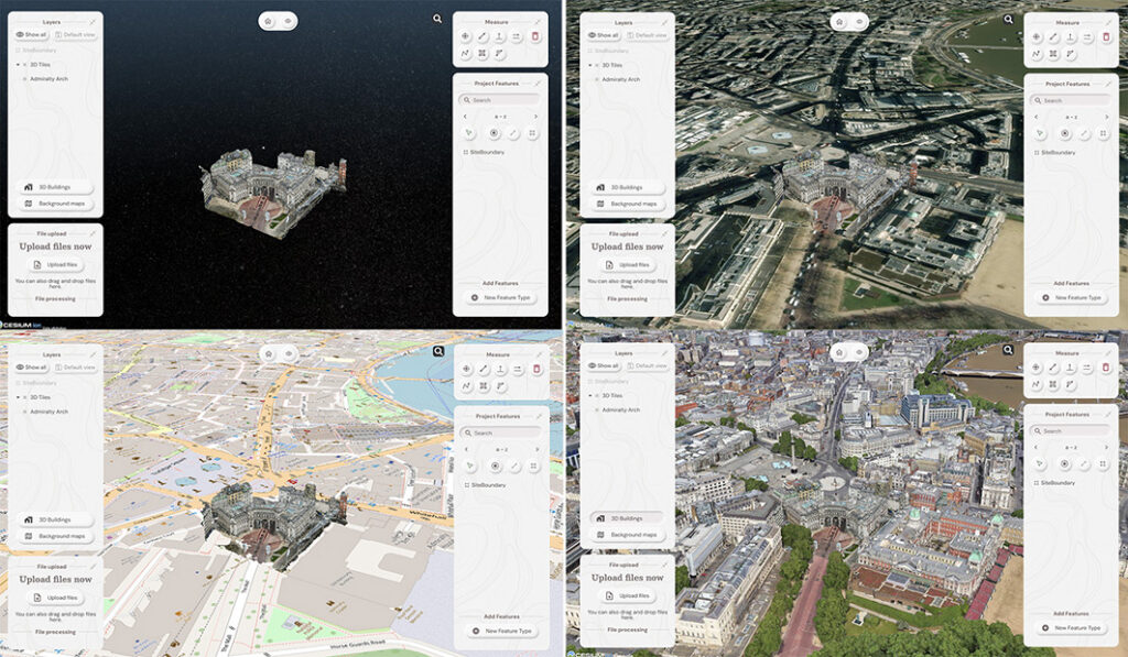
Top left: What you had. Remaining three pictures, adding context with SOARVO
Why it’s exciting? Our top five reasons
It’s extremely easy to use: The development’s been all about the user experience, with an interface built for ease of use. That’s why it looks and feels so different (in the best possible way) compared to other data sharing software out there.
Favourite feature of Paul Brodin, Technical Lead: “The visualisation functionality and the speed with which it loads. I know because I timed it – 15 seconds for a mobile mapping data set that previously took hours!”
It provides a unique view of your data compared to other platforms: Well, how does it do that? The answer is it provides context around your dataset and positions it in the real world. For example, your laser scan point cloud doesn’t sit in a black space, it’s positioned on to the background map of your choice from OS to Google to Bing. This opens up new doors with your clients. It’s all about making your data set relevant for its end users by providing visualisation in a rich 3D environment with analysis and measurement tools thrown in.
Favourite feature of Alan Browne, CEO and Co-Founder of SOARVO: “It’s all about the effortless processing of drone data – everything included and definitely no fuss required.”
It truly delivers on collaboration: Once your datasets are uploaded, you simply share a secure link to your chosen users and they can log in securely, via the cloud, for viewing or editing depending on their pre-determined rights. We don’t mess about with login limits – invite the whole team if you fancy because the whole point is sharing this information whether it be for visualisation, site planning, measurement, whatever.
Everyone’s invited: As well as unlimited log ins, the software handles data from just about every sensor under the sun, seamlessly combining output from drones, laser scans, GNSS, total stations, mobile mapping, mixed reality, 3D models, CAD and GIS.
It’s a standalone tool for drone data: Capture your aerial data and drop it straight into SOARVO to create your deliverables whether that’s an ortho-mosaic, point cloud, or 3D model. No extra software, no faff—just process, share, and crack on!
Favourite feature of Richard Gauchwin, Senior Product Manager: “For me, it’s all about how it looks and also hearing the amazing reactions from our early access users. As someone who used to be in sales, being able to say ‘yes’ to so many questions just proves we’ve built something genuinely unique here.”
But don’t just take our word for it…
We love feedback and our early access users have provided exactly that:
Soarvo provides us with a platform to automatically process drone orthomosaics and view them within a web-based geospatial data solution. This capability is greatly beneficial to us—having a one-stop shop for all our drone and GIS needs in a single platform is both unique and highly valuable.
The ability to easily share project updates with clients, alongside geospatial and media data, has resolved a long-standing need for us. We now have greater flexibility to share data with contractors and provide updates online, without the need to email GIS files or rely on others to know how to use complex GIS software.
Having a central online location where our team can share data and collaborate easily on projects with online easy to use GIS tools makes workflows and data sharing much more efficient and accessible. Soarvo has provided us with an opportunity to streamline data management within the team.
Ease of navigation in 3D
Speed of rendering large point clouds and ability to move them
Simple clean interface and comprehensive basemap data
Favourite feature of Gabriel Hradilek, Chief Operating Officer: “A simple one from me, but absolutely massive for our customers: how easy and secure it is to share data. It’s a big deal, trust me!”
Need to know more, contact KOREC
Here at KOREC we’re delighted to be the UK & Irish distribution partner for SOARVO. That means when you get your hands on the new software, you’re also getting over 30 years of our know-how, support, and training – all backed up in our T.R.U.S.T. brand promise. Join the waitlist at https://soarvo.com/