The driving force behind Soarvo’s launch? Pure genius and a bit of fire and frustration too. Soarvo have come up with something designed to rescue a geospatial community drowning in much needed, excellent, high-quality data, but restricted in what they can do with it. Think of it as throwing a life belt… but make it a carefully developed revolutionary 3D geospatial platform instead!
Here at KOREC we have a long history in the development of geospatial data platforms. Go right back to the earliest days of GIS in the 90’s and we were there, developing, supporting and working with the very best. So trust us when we say we know a good thing when we see it – and that good thing is Soarvo.
Why’s it different?
The obvious question is what is Soarvo, and the easy answer is of course found in its official description as a “…..revolutionary 3D geospatial data platform, which enables users to Aggregate, Illustrate and Collaborate all in one place.”
That’s exactly what it ‘does’ but what makes it really different is why and how. Let’s go back a couple of years or so when the geospatial industry was spoilt for choice when it came to sensors for generating extremely large, accurate data sets whether that be from mobile mapping, drones or 3D Laser Scanners. The hardware was doing a great job! But what wasn’t so great was what was happening in many offices. Without the mother of all PC’s and a significant investment in multiple software packages, skills and office time, our fantastic, captured data was becoming either a bottle neck holding up projects or simply siloed.
Great data sets aren’t meant to be hidden away, they need to be shared, seen, and collaborated on, not just admired by a select few. That’s why geospatial professionals across all industries – from surveying to rail to mapping – were on the hunt for something that could handle it all and turn those data sets into useful info, fast. But could they find anything? Nope, there wasn’t a single package that could do the job… until now.
Soarvo is born!
The Soarvo aim was to create something with exceptional functionality and security but with a user-friendly interface as inviting as the hugely popular design software, Canva. So, we created Soarvo from the ground up, taking end-user feedback on board at every step of the development process.
And now it’s ready.
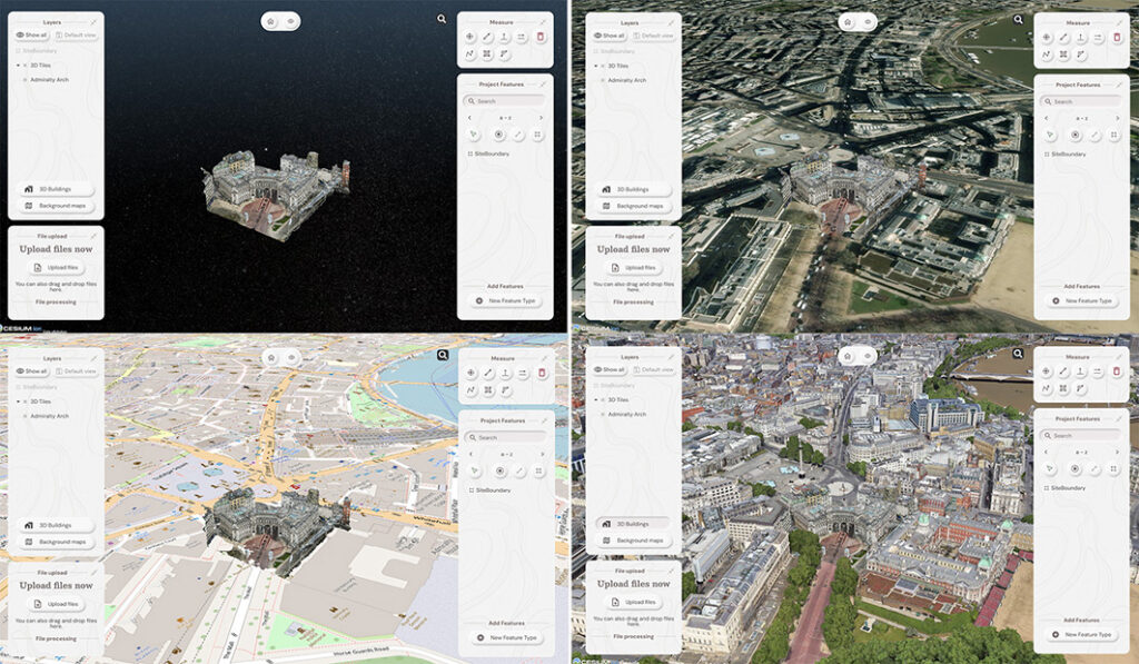
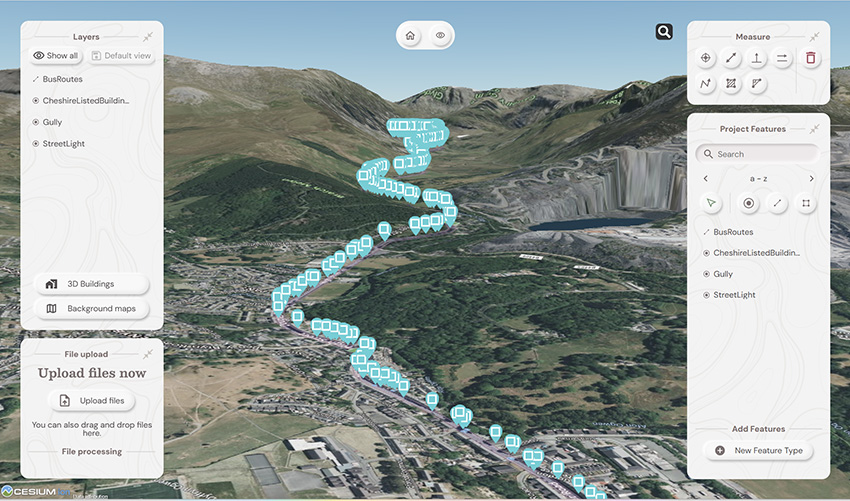
Top left: What you had. Remaining three pictures, adding context with SOARVO
Why it’s exciting? Our top five reasons
It’s extremely easy to use: The development’s been all about the user experience, with an interface built for ease of use. That’s why it looks and feels so different (in the best possible way) compared to other data sharing software out there.
Favourite feature of Paul Brodin, Technical Lead: “The visualisation functionality and the speed with which it loads. I know because I timed it – 15 seconds for a mobile mapping data set that previously took hours!”
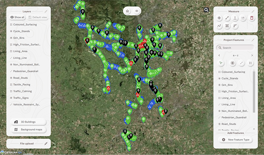
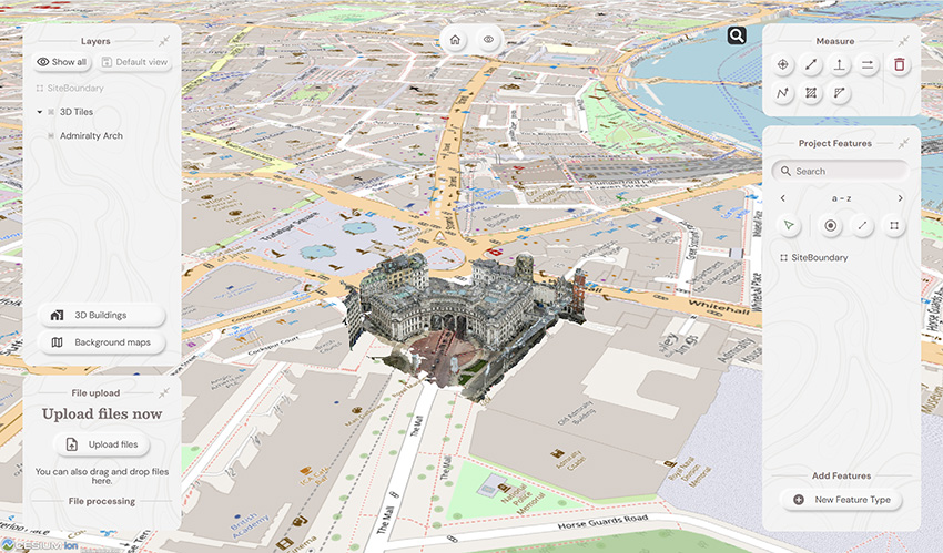
It provides a unique view of your data compared to other platforms: Well, how does it do that? The answer is it provides context around your dataset and positions it in the real world. For example, your laser scan point cloud doesn’t sit in a black space, it’s positioned on to the background map of your choice from OS to Google to Bing. This opens up new doors with your clients. It’s all about making your data set relevant for its end users by providing visualisation in a rich 3D environment with analysis and measurement tools thrown in.
Favourite feature of Alan Browne, CEO and Co-Founder of SOARVO: “It’s all about the effortless processing of drone data – everything included and definitely no fuss required.”
It truly delivers on collaboration: Once your datasets are uploaded, you simply share a secure link to your chosen users and they can log in securely, via the cloud, for viewing or editing depending on their pre-determined rights. We don’t mess about with login limits – invite the whole team if you fancy because the whole point is sharing this information whether it be for visualisation, site planning, measurement, whatever.
Everyone’s invited: As well as unlimited log ins, the software handles data from just about every sensor under the sun, seamlessly combining output from drones, laser scans, GNSS, total stations, mobile mapping, mixed reality, 3D models, CAD and GIS.
It’s a standalone tool for drone data: Capture your aerial data and drop it straight into SOARVO to create your deliverables whether that’s an ortho-mosaic, point cloud, or 3D model. No extra software, no faff—just process, share, and crack on!
Favourite feature of Richard Gauchwin, Senior Product Manager: “For me, it’s all about how it looks and also hearing the amazing reactions from our early access users. As someone who used to be in sales, being able to say ‘yes’ to so many questions just proves we’ve built something genuinely unique here.”
But don’t just take our word for it…
We love feedback and our early access users have provided exactly that:
Soarvo provides us with a platform to automatically process drone orthomosaics and view them within a web-based geospatial data solution. This capability is greatly beneficial to us—having a one-stop shop for all our drone and GIS needs in a single platform is both unique and highly valuable.
The ability to easily share project updates with clients, alongside geospatial and media data, has resolved a long-standing need for us. We now have greater flexibility to share data with contractors and provide updates online, without the need to email GIS files or rely on others to know how to use complex GIS software.
Having a central online location where our team can share data and collaborate easily on projects with online easy to use GIS tools makes workflows and data sharing much more efficient and accessible. Soarvo has provided us with an opportunity to streamline data management within the team.
Ease of navigation in 3D
Speed of rendering large point clouds and ability to move them
Simple clean interface and comprehensive basemap data
Favourite feature of Gabriel Hradilek, Chief Operating Officer: “A simple one from me, but absolutely massive for our customers: how easy and secure it is to share data. It’s a big deal, trust me!”
Need to know more, contact KOREC
Here at KOREC we’re delighted to be the UK & Irish distribution partner for SOARVO. That means when you get your hands on the new software, you’re also getting over 30 years of our know-how, support, and training – all backed up in our T.R.U.S.T. brand promise. Join the waitlist at https://soarvo.com/
We are delighted and proud to announce that our KOREC Group CEO, Alan Browne, has been named on the EY Entrepreneur of the Year shortlist for 2022. Alan’s nomination is for ‘Established Entrepreneur’, one of three categories that also include ‘Emerging Entrepreneur’ and ‘International Entrepreneur’. Following judging of the shortlist the overall winner for Ireland, who will also be a global finalist, will be announced in November.
EY Entrepreneur Of The Year is a unique global programme running in more than 60 countries that recognises entrepreneurial achievement among individuals and companies that demonstrate vision, leadership and success. All finalists will be invited to join the EY networking event in Austin, Texas.
In Alan’s case, the nomination is a fitting recognition of his 27 years as CEO of KOREC that has culminated in a recent period of massive growth for the company resulting in a recruitment drive to fill 30 new positions, in a range of departments, across the UK and Ireland.
Alan Browne said: “I’m delighted to receive this nomination because it’s a truly exciting recognition of what we have achieved at KOREC over the years in a demanding, technology led environment. Our experience has allowed us to build and define our company culture and that means we’ve also created a great workplace, a great team and a world-class ethos.”
Additional information about why Alan was shortlisted
Alan has been entrepreneurial from an early age. At just 27 years old he started a company in Ireland called PCI with a single employee. He felt that large machines on construction sites could be used far more effectively and accurately if they were equipped with a technology called Machine Control (based on laser measurement) that was still very much in its infancy.
In the first year of working, the company had a turnover of £110k. Today KOREC Group will turnover £35m across the Group. From the initial days of just two employees, KOREC now employs over one hundred people and is growing all the time. Currently, KOREC is seeking to recruit for 30 new posts in 2022.
Alan’s strength, and that of the KOREC Group, lies in his ability to spot key business areas whilst they are still in their infancy and in some cases, whilst there is still opposition to the technology. A great example of this is his move into the commercial drone market in 2011 becoming the first in the UK to do this. He worked closely with drone manufacturer senseFly to become one of their most influential partners. This relationship is still strong today and despite initial opposition, many survey companies are now reliant on drone technology and see drones as a vital addition to the surveyor’s toolbox.
Most recently Alan has moved KOREC towards robotics, again a technology that is still in its earliest phases within the construction and survey industries. This move has seen KOREC working with major engineering contractors in the UK and Ireland as they adopt Spot the Dog, an agile robot developed by Boston Dynamics. Teamed with Trimble laser scan technology, Spot is equipped to carry out 3D laser scans, autonomously, in conditions inhospitable to a surveyor or to just carry out mundane and repetitive tasks to free up skilled engineers or surveyors to focus on other aspects of a project.
Alan has a proven ability to spot key business areas early, including niche markets that require time and investment, along with the ability to understand a customers’ specific and unique project requirements. He has placed KOREC in an advantageous position by connecting customers to the global leading software, hardware, and services technology company that is Trimble, whilst retaining local knowledge and a sense of community. This is what has enabled him to bring cutting edge technology to projects, whilst also developing bespoke software solutions that fit the bill precisely.
The KOREC mission is a simple and one that Alan adheres closely to in every decision he makes whilst also ensuring that the company reflects this overall vision.
The KOREC Mission:
When operating in the natural and built environment, consistent success demands accuracy, safety and speed, whilst reducing costs and environmental impact.
At KOREC, we believe embracing geospatial solutions will transform your outcomes and deliver that success.
KOREC’s mission is to empower you to measure, map and manage the natural and built environment.
Combining industry knowledge, with intuitive software, and world-leading positioning technology, KOREC transforms your operations bringing certainty to your decision making.
Finally, Alan has also invested a lot of time and effort in creating a KOREC culture that is both fun and rewarding to work in.


Call us today on 0345 603 1214 or email at info@korecgroup.com
Combining a high level of technical nous with a user-friendly delivery (Eugen is a part time lecturer at the acclaimed Dublin Institute of Technology) our new KOREC Geospatial Sales Consultant also brings extensive practical experience to the team, having worked on site in a range of survey disciplines as well as at the sharp end of Murphy Surveys as a former Quality and Technical Manager specialising in site and office workflows.
A renowned Chartered Geomatics Surveyor, Eugen is a professional member of the Society of Chartered Surveyors Ireland (SCSI) and the Royal Institution of Chartered Surveyors (RICS). Elected member of the Geomatics Professional Group in SCSI from 2011 to 2013 and from 2015 to present, where he adapted the RICS’s “Scale” and “Map Projections and Scale Factors” client guides for SCSI and wrote “OSGM15 – Geoid Changes for Ireland” SCSI client guide.
Amongst all of this Eugen also volunteers his time with Coder Dojo, a global network of free computer programming clubs for young people. When he does get any spare time, he enjoys a spot of swimming.
We are excited and proud to have Eugen on board with us at KOREC as a Geospatial Solutions Consultant in Dublin, Ireland. We are sure that with all his knowledge and experience, he will be a great asset to KOREC and our customers.
Welcome to KOREC Group team, Eugen!
X Marks the Spot
As with all good adventure trails X usually marks the spot of hidden treasure. Well, we’re pleased to tell you that we’ve got a real spot of treasure in store.
KOREC are giving 7 lucky followers the chance to win an all expense paid trip to Stockholm for a Trimble SX10 Factory Tour in Danderyd, Sweden on the 12th and 13th June 2018.
How can you get your hand on a ticket we hear you ask? Well it’s very simple really. Send us a picture or short video of your Trimble equipment being used in a tough or unusual environment. The best image / video wins.
You have until April 26th to send us your entries. Just email us at marketing@korecgroup.com
We’ve also got lots of other ways you can win a ticket. Keep an eye on our socials for further details.