As a result of their recent successful integration into Cansel Group, KOREC Group and Survey Solutions Group (SSG) are pleased to announce that both companies are now authorised Propeller distributors covering the UK, Scotland and Ireland.
The two companies will sell and support Propeller’s leading cloud-based platform for drone mapping, 3D site analytics and earthworks management.
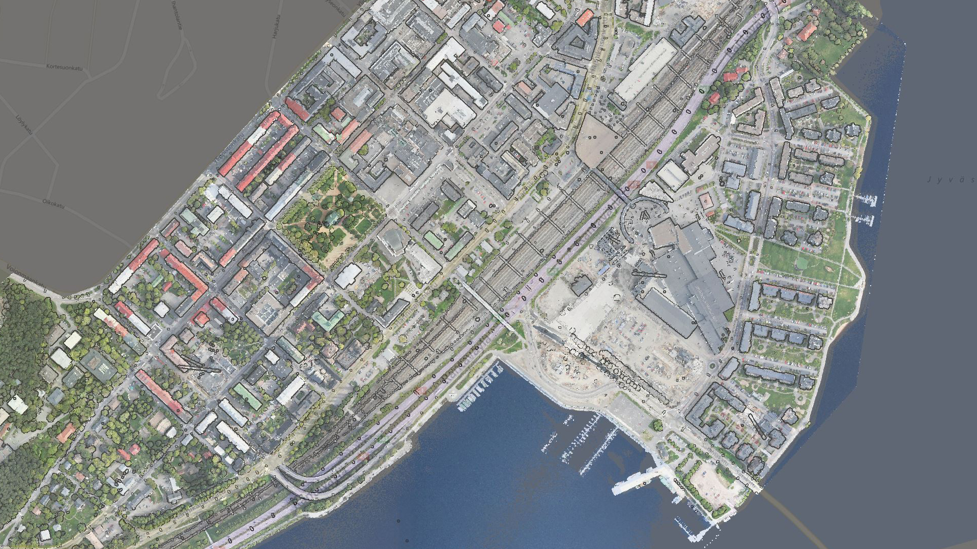
KOREC and SSG customers will have a proven solution for processing and analysing drone data across a range of applications including surveying, mapping, construction, housebuilding, aggregates, mining and waste management. The Propeller distributorship will also enable KOREC and SSG to expand into the BYOD (bring your own data) market.
Compatible with all the major UAVs sold by both KOREC and SSG, Propeller can also be fully integrated into the Trimble eco-system via the Trimble Connect common data environment.
Benoit Mallen, President UK and Ireland, Cansel Group said:
“At Cansel, with KOREC Group and Survey Solutions Group now fully integrated, we’re committed to delivering user-friendly field-to-finish workflows. The Propeller agreement brings their leading cloud-based drone mapping, 3D analytics, and earthworks platform to customers across the UK, Scotland, and Ireland enabling faster, more actionable insights from drone data in surveying, construction, aggregates, mining, waste management, and more.”
Sam Long, Account Executive, Propeller Aero said:
“We’re excited to welcome KOREC and SSG as new distributions for Propeller Aero. KOREC and SSG have built an outstanding reputation within the geospatial industry, and their expertise and strong relationships across the sector make them a natural fit for Propeller. Since they already provide many of the survey-grade drones our customers rely on, this partnership makes it easier for surveyors to process drone data, reduce photogrammetry workloads and share accurate site insights with teams across the business. We’re really looking forward to bringing the Propeller platform to KOREC and SSG’s customers and helping them unlock the value of accurate aerial data and streamlined site workflows.”
For more information or to arrange a demonstration, please contact www.korecgroup.com/contact or www.surveysolutionsgroup.co.uk
Propeller will be attending KOREC’s upcoming UAV days in March and April with further dates in Scotland to be announced by SSG.
Download a PDF of the release here
About KOREC Group
KOREC Group specialises in the provision of intuitive software and world lead positioning technology for the measurement, mapping and management of the natural and built environment.
KOREC is the UK and Irish distributor for Trimble and operates nationwide out of offices in Huntingdon, Liverpool, Dublin and Craigavon (NI). .In December 2025, KOREC joined the Cansel Group, a respected leader in geospatial technology with established operations across Canada and North America. www.canselgroup.com www.korecgroup.com
About Survey Solutions Group
Established in 1993, Survey Solutions Group provides high quality survey systems, for sale or hire, backed up by its service and repair centre, technical support and training service.
In 2001 it became the only authorised Trimble distributor in Scotland for all Geospatial solutions and in 2025 joined the Cansel Group, a respected leader in geospatial technology with established operations across Canada and North America. www.canselgroup.com http://www.surveysolutionsgroup.co.uk/
About Propeller
Propeller Aero is a leading global provider of cloud-based drone mapping, 3D site analytics and earthworks management solutions. Founded in 2014 in Sydney, the company has grown from a startup into a trusted industry player with offices in Denver, Manila, and Amsterdam. www.propelleraero.com
KOREC is delighted to announce that it has signed a reseller agreement with Terrasolid to sell the company’s software which is widely recognised as the industry standard for LiDAR and image data processing.
The agreement is for the UK and Ireland and covers the main Terrasolid product suite including TerraScan, TerraModeler, TerraPhoto, TerraMatch, TerraStereo and TerraBatch as well as UAV and Lite versions.
Developed specifically to meet the demanding requirements of geospatial, engineering, and environmental professionals, Terrasolid’s software provides the versatile tools needed to create everything from 3D vector models and feature extractions to orthophotos and advanced point cloud visualisations, regardless of data source or sensor.
This agreement reinforces KOREC’s position as a one-stop solution provider – hardware, software, and support & training – and enhances the company’s ability to deliver complete end-to-end workflows for 3D data capture, processing, and analysis.
“For 25 years Terrasolid has been the industry standard for processing LIDAR data from dynamic laser scanning solutions including Mobile Mapping, UAV, fixed wing, and handheld SLAM,” said Mark Reid, UK Sales Director at KOREC. “The software is agnostic and complements our existing portfolio to help customers efficiently process and extract value from their captured datasets with even greater accuracy and efficiency.”
“For Terrasolid, the partnership with KOREC represents strengthened access to a key geospatial market,” said Xabier Eraña, VP Sales at Terrasolid. “With KOREC’s deep reach into surveying, mapping and infrastructure sectors in the UK & Ireland, Terrasolid is better positioned to deliver its 3D reality-capture software to critical industry workflows.”
For more information or to arrange a demonstration, please visit www.korecgroup.com/contact
ENDS

About KOREC Group
KOREC Group specialises in the provision of intuitive software and world lead positioning technology for the measurement, mapping and management of the natural and built environment.
KOREC is the UK and Irish distributor for Trimble (www.trimble.com) and operates nationwide out of offices in Huntingdon, Liverpool, Dublin and Craigavon (NI). www.korecgroup.com
About Terrasolid
Terrasolid develops world-leading software solutions for processing 3D point clouds and imagery collected from airborne, mobile, and terrestrial sensors. Based in Finland, Terrasolid’s applications are trusted by mapping professionals and engineers in over 100 countries. www.terrasolid.com
PRODUCT SPOTLIGHT
Discover TerraScan
TerraScan from Terrasolid is the industry standard for managing and processing point clouds – a reputation its held for over 25 years. TerraScan is the main app in the Terrasolid software suite, designed to make it easy for you to manage, process and visualise point cloud data. Deliverables include high quality classified point cloud data or vector data to be used in various engineering and maintenance applications.


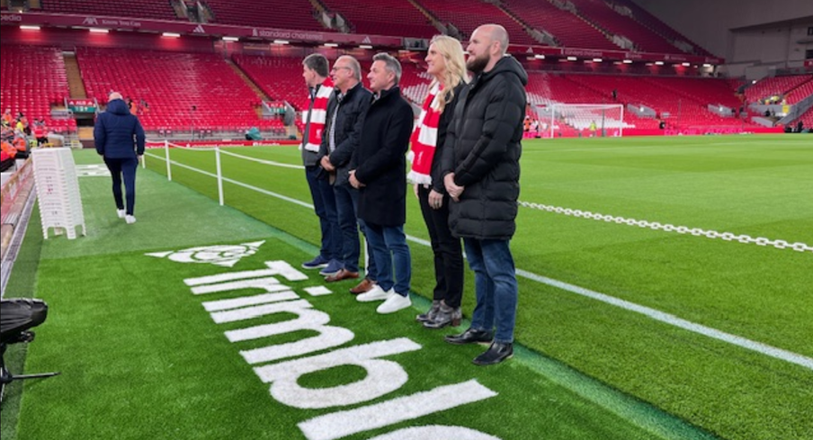
David Hodkinson and Mark Poveda (centre)
Liverpool Football Club (LFC) is widely recognised as one of the most popular clubs in the world’s most popular sport and at a recent home game this month we’re delighted to announce that its name became publicly linked with another high achiever and one especially close to our own hearts – Trimble!
On October 31st, Trimble announced a new multi-year global sponsorship with Liverpool Football Club (LFC) and became a recognised partner. In addition to the sponsorship, LFC will employ Trimble technology in the design and development of the club’s infrastructure including on the recently announced refresh of the LFC Academy, which aims to develop the future stars of football. This will include a starring moment for Trimble SketchUp which will be used to reimagine the high-performance centre into a truly industry-leading space for young footballers to learn.
Expect lots of visibility of the Trimble logo around the LFC stadium and its digital channels and of course plenty of photos from the KOREC team and any lucky customers who get to be a Trimble guest!
Six top moments through the ages – have we got the list right?
- The Miracle of Istanbul (2005): Down 3-0 at halftime in the Champions League final against AC Milan, Liverpool staged the greatest comeback in final history.
- Bill Shankly’s best football quote of all time: “Some people think football is a matter of life and death. I assure you, it’s much more serious than that.”
- The Kop’s roar measured at 130.9 decibels In a 2019 match vs. Barcelona, Anfield’s decibel level hit 130.9—louder than a jet taking off at 100 meters.
- The “This Is Anfield” plaque: Shankly installed the famous plaque in the tunnel to intimidate opponents and remind his players: “This is Anfield—play like gods.” Opposing managers still touch it for luck… or fear.
- 2024 Premier League Champions: Liverpool clinched the title on April 27, 2025, with a thrilling 5-1 home win over Tottenham Hotspur.
- Best ever rendition of ‘You’ll never walk alone’: It’s back to the Miracle of Istanbul in 2005 for this one!
A front row seat!
What better way to celebrate the shared values of this Trimble / LFC collaboration – precision, innovation and commitment – than by witnessing it ourselves. With our north west office just 5 miles from Anfield, two of KOREC’s finest, Mark Poveda (Managing Director) and David Hodkinson (Group Finance Director) were lucky enough to be Trimble’s guests for the game on 1st November v. Aston Villa (spoiler: LFC won 2-0), and as a lifelong fan, David was more than happy to share his experiences:
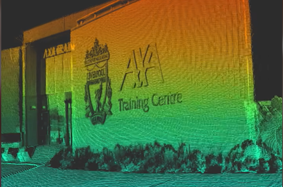
“The day started with lunch in Liverpool before being bussed over to the AXA Training Centre for a tour of the 1st team and Academy teams training facility over in Kirkby.
This is a state-of-the-art facility with pitches that wouldn’t look out of place as golf greens!
We saw Arne Slot’s office and all the indoor and outdoor training facilities and the press conference room. They also have all the myriads of Trophies on display that Liverpool have won – It was a very impressive facility.
We were then bussed back to Anfield for a tour of the stadium – including getting to stand on the world famous Kop and then pitch side for the photos with the new Trimble logo. It was great to be down on the pitch in the full glare of all the lights giving us a taste of what it must be like as a player.
Then it was up to the “Legends Lounge” for our top-notch food (and drink) – including a talk from Emile Heskey (Liverpool & England star).
Kick off was 20.00 in our halfway line seats – and I am pleased to report that Trimble brought us a change of fortune and we won (following 4 league defeats in a row!) – So Trimble are now 100% with LFC!
It was a brilliant day and great to see the behind the scenes operations that underpin what you see on the pitch!
Many thanks to our hosts Trimble and LFC for a superb day!”

Trimble Becomes Official Global Partner with Liverpool Football Club
New Wingtra-Trimble partnership brings seamless data integration for KOREC drone customers
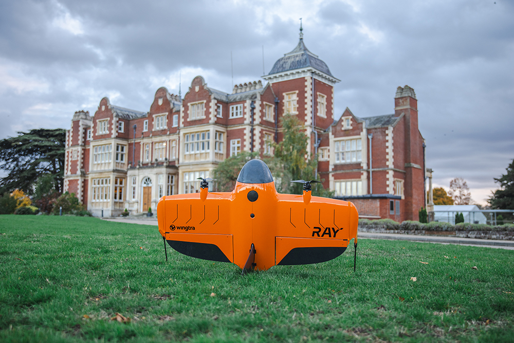
The WingtaRAY at the KOREC Trimble User Conference held in Cambridge in October (KTUC 2025)
KOREC is delighted to announce that a new partnership between Wingtra and Trimble will deliver tighter integration between Wingtra’s industry-leading drone solutions and Trimble’s world-class survey and mapping workflows.
Delivering a smarter way to get high-quality data, the joining of these powerful Trimble and Wingta survey tools will cut field time, minimise manual work and ensure users achieve accurate, actionable results far faster.
Available now is Trimble-native file support in WingtraCLOUD enabling quick drag-and-drop compatibility. This will enable KOREC customers to create survey sites instantly by uploading Trimble Business Center export files in .JXL (no manual setup), Skip RINEX conversions (just drag and drop your TO2/TO4 files) and work faster in local coordinate systems with fewer errors
Coming in 2026 is Wingtra’s cm-level positioning powered by Trimble correction services with no need for a base station. Users will be able to automatically apply cm-accurate corrections in WingtraCLOUD and establish known points globally with PPP support. Plus users will also have the ability to sync and export maps directly from WingtraCLOUD to Trimble Connect and TBC.
Future data connectivity will be ongoing throughout 2026 with tighter Trimble + Wingtra hardware/software integrations ensuring data flows from flight to final deliverable, without interruptions.
John Cartlege, Mapping & GIS Business Area Manager, KOREC said:
“Trimble leads in precision positioning, data integration and advanced GNSS solutions, Wingtra drives innovation in aerial mapping with its WingtraRAY VTOL drone technology and KOREC champions emerging technologies, bringing these innovations to our UK and Irish customers through our local expertise, support, and consultancy.
“We look forward to doing what we do best – helping KOREC customers seamlessly integrate these solutions into their workflows for greater efficiency accuracy and value.”
For more information or to arrange a demonstration, contact the KOREC Mapping Team at on0345 603 1214or visit www.korecgroup.com/contact
ENDS