“A viable solution that doesn’t break the bank”
Lloyds Datum Group (now part of SOCOTEC UK and Ireland) has pioneered a landmark project on an abandoned mine site in Northern Ireland. It is the country’s first large-scale ground […]


Lloyds Datum Group (now part of SOCOTEC UK and Ireland) has pioneered a landmark project on an abandoned mine site in Northern Ireland. It is the country’s first large-scale ground […]
Download a formatted PDF of the story here
Established in 2004, Belfast based Lloyds Datum Group (LDG Datum) specialises in foundation testing, structural monitoring, geotechnical services and related civils work. Under Director Mark Hodgen, the company has built on its reputation for trusted advice and innovative technology with Mark working closely with both customers and suppliers across all areas of the business.
This practical mix of hands-on experience and focus on what clients actually need, along with an ethos of working with new technology, has led to them working closely with KOREC to become the first company in Ireland to use Worldsensing’s new GNSS Meters on a mass project.
As the owner of Northern Ireland’s 2,400 abandoned mine workings, the Department for the Economy (DfE) carries out a comprehensive mine monitoring programme and implements mitigation measures where required. Over a number of decades, the DfE has faced ongoing challenges regarding ground stability at three abandoned mine sites in Carrickfergus: Maiden Mount Mine (closed in 1958), French Park Mine (closed in 1952), and Duncrue Mine (closed in 1938). These historically significant reminders of Northern Ireland’s strong salt mining heritage are affected by substantial underground voids created through decades of extraction. Consequently, there have been reports of ground displacement dating back as far as 1896 at the Duncrue mine.
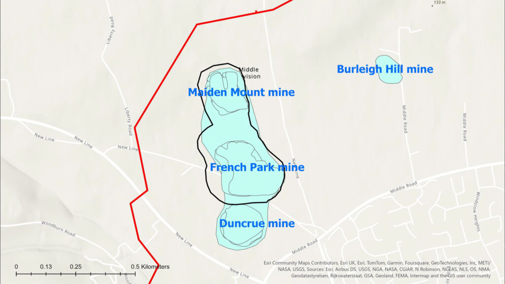
Area covered by the three mines
The site has therefore been monitored regularly since 1990 using manual topographical surveys and LiDAR aerial photography, methods that despite being time-consuming and costly (running into millions of pounds per year), have been relied upon for many years.
However, in its efforts to assess the stability of lands adjacent to the mine, the DfE wished to provide further assurance within a wider monitoring and assessment programme which would include the recording of long-term ground stabilisation patterns over the mine site and adjacent lands by significantly increasing the amount of high-quality data collected, all backed up by regular reports.
Already familiar with Worldsensing tilt-meters, LDG Datum were perfectly positioned to work with supplier KOREC and develop a proposal for a low-cost, highly accurate network of sensors to run as a comprehensive two-year monitoring programme, with potential flexibility for extension.
These sensors would be the newly released Worldsensing GNSS meters which feature advanced multi-band RTK technology and innovative edge processing for millimetric precision with great reliability.
Whilst the site already presented complex geological challenges that would require real-time millimetre precision monitoring, Mark and the LDG Datum team also had to contend with a number of additional considerations:
Access restrictions – although the area over the mines is owned by the DfE, the wider area to be monitored has multiple owners with some of the land used for agricultural livestock.
Site size – covering such a large area, the solution would have to be cost-effective, provide high accuracy data, have minimal maintenance requirements and offer reliable, long-range wireless communication in a rural location.
Weather conditions – equipment would have to be suitable for an open site that can be subject to extreme wet and cold as well as storm events.
Cost-effective – any system would have to provide high-level monitoring information as specified by the DfE but also provide value for the taxpayer. Alternative survey methods would require two people visiting the site daily – an extremely heavy demand on resources and budgets.
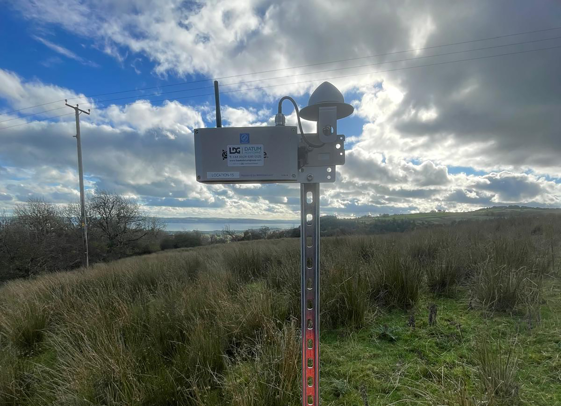
To meet these requirements, LDG Datum implemented an advanced GNSS-based monitoring solution featuring the deployment of twenty-two Worldsensing GNSS Meters strategically positioned across the three mine sites.
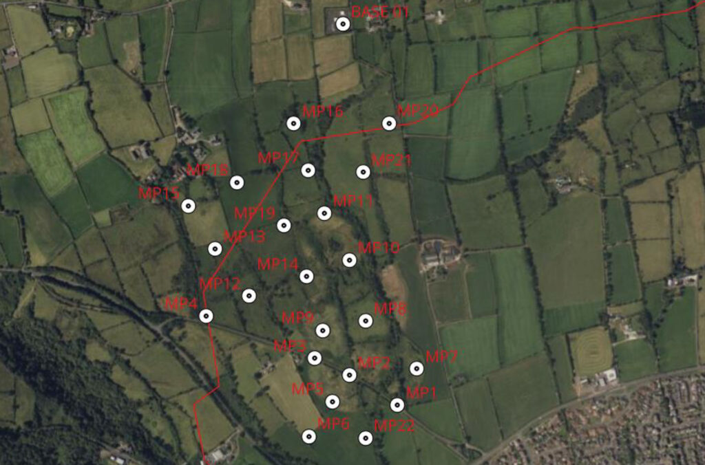
The flexible configuration of the meters allowed a twenty-third unit to serve as a base station, significantly reducing overall costs. All data is wirelessly transmitted to Trimble’s T4D monitoring software for visualisation, analysis, and reporting.
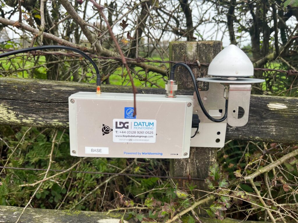
LDG Datum was provided with a map and GPS coordinates and Mark and his team positioned the twenty-two sensors at strategic locations across the sites using 550 mm screws. The base station sensor was mounted on four Kelly blocks on hard standing ground at the top of a hill.
A central gateway system was also installed to enable data collection and transmission, supported by a solar panel setup to ensure autonomous, continuous operation throughout the project’s lifecycle. Data is relayed once an hour, with reports generated in Trimble T4D and sent to the client daily.
The scheme was established in October 2025 and with it now firmly established and running to plan, Mark reports that it has been extremely well received.
“Worldsensing’s GNSS Tilt Meters have enabled us to deliver essential ground stabilisation data, which we can use for evidence-based decision-making regarding land use planning, development restrictions and potential remediation strategies. The client is very satisfied with both the level of information provided and the value for money.
“The project’s potential for extension demonstrates its value in providing ongoing surveillance of these historically significant but potentially hazardous sites, contributing to enhanced public safety and informed infrastructure planning decisions.”For further information on any of these products, please contact us here.