Reliable field data capture is vital for foresters to manage anything from infrastructure, to harvesting, disease monitoring and overall maintenance to name just a few.
It’s an industry in which KOREC is regarded as a market leader thanks to a combined offering of drone technology, image analysis software and advanced GNSS handhelds and laser range finders.
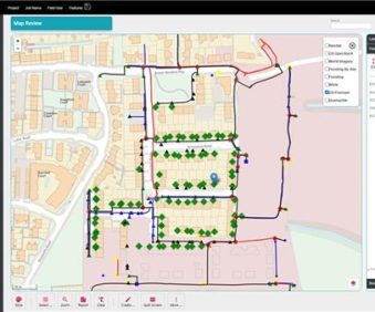
The latest edition to our forestry portfolio is the specialised Canopy module of our K-MATIC field data capture software which combines all the usual features with extra built-in tree functionality and visualisation tools. Perfect for undertaking British Standard tree surveys, key benefits include live graphic representation of tree canopy measured in four directions (N,S,E,W) and calculations and graphic representation of root radius.